How Do We Deal with Our Aging Structures? - Water Resources ...
How Do We Deal with Our Aging Structures? - Water Resources ...
How Do We Deal with Our Aging Structures? - Water Resources ...
- No tags were found...

Create successful ePaper yourself
Turn your PDF publications into a flip-book with our unique Google optimized e-Paper software.
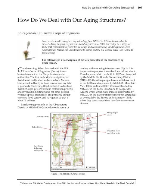
<strong>How</strong> <strong>Do</strong> <strong>We</strong> <strong>Deal</strong> <strong>with</strong> <strong>Our</strong> <strong>Aging</strong> <strong>Structures</strong>?107<strong>How</strong> <strong>Do</strong> <strong>We</strong> <strong>Deal</strong> <strong>with</strong> <strong>Our</strong> <strong>Aging</strong> <strong>Structures</strong>?Bruce Jordan, U.S. Army Corps of EngineersBruce received a BS in engineering technology from NMSU in 1994 and has worked forthe U.S. Army Corps of Engineers as a civil engineer since 2003. Currently, he is assignedas the lead geotechnical engineer for the design and construction of the Albuquerque LeveeRehabilitation, Middle Rio Grande (Isleta to Belen), and the Rio Grande Levee (San Acacia toSan Marcial).The following is a transcription of the talk presented at the conference byBruce Jordan.Good morning. When I started <strong>with</strong> the U.S.Army Corps of Engineers (Corps), it wasbeaten into me that the Corps has two mainauthorities. The first authority is navigation, butthat doesn’t really affect us here in New Mexico.<strong>Our</strong> second authority is flood control and my talkis primarily concerning flood control. I understandthat the Corps gets involved in restoration projectsand involved in holding water for other people;we have special authorities, but primarily our jobconcerns flood control and navigation so that iswhat I'll address.I am looking primarily in the AlbuquerqueDistrict at Middle Rio Grande levees in terms ofdealing <strong>with</strong> our aging infrastructure (Fig 1). It isimportant to pinpoint those that I am talking about:Corrales levee, which we built in 1997 and is ownedby the Middle Rio Grande Conservancy District(MRGCD); the Albuquerque levees, which we builtin the 1950s are also owned by MRGCD; MountainView Isleta units and Belen Units constructed byMRGCD in the 1930s; San Acacia to Bosque delApache Units, which were initially constructed byMRGCD in the 1930s but have since been upgradedor overbuilt by the Bureau of Reclamation (BOR)when they constructed their low-flow conveyancechannel.Corrales LeveeAlbuquerqueLeveesBelen UnitsMountain Viewand Isleta UnitsSan Acaciato Bosquedel ApacheFigure 1. Middle Rio Grande levees55th Annual NM <strong>Water</strong> Conference, <strong>How</strong> Will Institutions Evolve to Meet <strong>Our</strong> <strong>Water</strong> Needs in the Next Decade?
108Bruce JordanLet me mention a bit of history of floodsin the Middle Rio Grande: the Corrales 1874estimated a flood-flow of 100,000 cfs; in 1904, theAlbuquerque Journal reported a four mile-wideriver at Albuquerque; in 1929, in the San AcaciaUnit, we lost the town of San Marcial in heavyAugust rains; in 1941, we had the Belen Bridgewashout. In 1925, the MRGCD was formed. It wasinitiated in 1923 but had to wait for a court decisionto determine that it was constitutional. From 1930to 1935, MRGCD constructed approximately 190miles of levee, spoil embankment, primarily aspart of the drainage. The MRGCD calls this theRiverside Drain that helps drain some of the watertable for irrigable lands in order to put them backinto development. So projects were mostly spoillevee construction, which was common for thattime. From 1953 to 1957, the Corps constructedPhases I, II, and III of the Albuquerque Levees as aflood control project, which is an engineered levee.From 1951 to 1959, the Bureau of Reclamationconstructed the Low Flow channel to ElephantButte, upgrading those levees in the Socorro area.In 1997, the Corps came back and constructed theCorrales levee.Figure 2 is a construction drawing for theAlbuquerque levees depicting the differencebetween a spoil levee and an engineered levee.You can see the spoil pile is non-engineered; ithas thickness but does not have any definite slopecontrol. The figure shows the spoil levee beingmoved and actually being used as the borrowmaterials for the engineered levee. The installationof the toe-drain system helped relieve pressure so itdidn't escape.In 2005, the Corps provided a report to Congresson the condition of the Albuquerque levees. Aspart of that report, I, along <strong>with</strong> the other engineersin the district, surveyed those levees to ascertaintheir true condition. As you can see in Figure 3, wehave animal burrows in the Albuquerque levees.The photos in the figure are all engineered levees.<strong>We</strong> have sloughing of the Riverside drain; thesubsurface discharge pipe in the top right photo hasbeen exposed by about 20 feet, so we’ve lost that.The actual drainage system has been compromisedby sedimentation. And then we have our famousand lovely trees, which have been an issue for theCorps for the last five years.(No scale:)Figure 2. Typical levee section from the Albuquerque levees construction drawingsDecember 1-3, 2010
<strong>How</strong> <strong>Do</strong> <strong>We</strong> <strong>Deal</strong> <strong>with</strong> <strong>Our</strong> <strong>Aging</strong> <strong>Structures</strong>?109seems pretty stable, but they have experiencedcatastrophic failure of the levee further south ofSocorro from seepage coming through the levee.Figure 3. Current Albuquerque levee conditionsFigure 4 shows the un-engineered levee atBosque Farms, and in 2005 we topped out on adischarge from Cochiti of about 6,500-7,000 cfsin this area. <strong>We</strong> tried to stay at 7,000 cfs for abouta week, but the conditions made us back off thedischarges. There was subsequent sloughing of theRiverside Drain. It was a fast occurring event so weweren’t necessarily worried about losing the leveefrom a breech in the levee, but losing the leveefrom the water seepage coming under the levee (afoundation issue) and breaching the levee from itwashing away from underneath was a concern.Spoil Bank LeveeNewDrain BankOriginallyHereMRGCD River side DrainFigure 4. MRG Levee (Bosque Farms) conditionsFigure 5 shows 2005 runoff in the Socorro area.The BOR had extensive problems <strong>with</strong> the way thatthe levee was constructed. The low-flow channelborrow material was dumped on top of the originalspoil levee and they found voids <strong>with</strong>in thatlower section and have had to fight the resultingseepage. The actual bank of the low-flow channelFigure 5. Socorro Levee conditionsChanges in criteria for levees for the Corpshave been made to help combat some of thecondition problems that we have seen over thelast 50 years from studying at Albuquerquelevees. <strong>We</strong> have adopted a change in our filterdesign criteria, which was first presented by theNatural <strong>Resources</strong> Conservation Service (NRCS).It is contained in chapter 26 of their NationalEngineering Handbook (Part 633), and we at theCorps have adopted that as part of our levee anddam construction manual. Another criteria changedeals <strong>with</strong> vegetation on the levees. The Corpshas, since at least the 1980s, had guidance forkeeping trees out of levees, although guidelineswere not always widely executed (ETL 1110-2-571"Guidelines for Landscape Planting and VegetationManagement at Levees, Floodwalls, Embankment,Dams, and Appurtenant <strong>Structures</strong>"). <strong>We</strong> havesince clarified that and shown that we now needa 15-foot minimum root-free zone. <strong>We</strong> would likefor the levee to be vegetated but only <strong>with</strong> grasses.<strong>We</strong> also do not want tall grasses because we needto be able to inspect for the presence of animalburrows. During times of flood, we need to be ableto evaluate where the seepage is coming from, ifseepage is present. The ETL has been finalizedafter a thorough three-year process of white-papercomments.Current Albuquerque construction studiesinclude the Albuquerque Levees Condition Report2005, which recommends rehabilitation of thecurrent levees. In my eyes, this means completely55th Annual NM <strong>Water</strong> Conference, <strong>How</strong> Will Institutions Evolve to Meet <strong>Our</strong> <strong>Water</strong> Needs in the Next Decade?
110Bruce Jordanremoving the existing levee, putting in a newdrainage system, and then putting the levee backdown. It will include hydrology upgrades so itmight not be the same size as the current levee.The current levee is built for a 42,000 cfs event, butthat is pre-Cochiti. Cochiti takes the peak off ofthat number quite a bit. Another study producedthe Middle Rio Grande Flood Protection, GeneralReevalution Report for Mountain View, Isleta, andthe Belen Units, and a third report is for the RioGrande Floodway, Limited Reevaluation Reportfor San Acacia to Bosque del Apache. Preliminaryestimates for construction are: a $120 million forAlbuquerque, $100+ million for the Middle RioGrande Flood Protection, and $115 million for theRio Grande Floodway (San Acacia to Bosque delApache).What does this mean for our water? Figure 6 isfrom Mussetter Engineering Inc.’s hydraulic reportfor the Middle Rio Grande and Albuquerque levees.It shows the 500-year snowmelt event being routedthrough Albuquerque. You can see the CorralesLevee, the Albuquerque levees, Paso del Norte andMontano bridge, and that floodwaters stay <strong>with</strong>inthe two levee systems. It is hard to see at this scalebut the red boxes are for 100-day durations. <strong>We</strong>are describing floodwater up against the levee for100 days, which is quite a long time to depend onthat levee. Figure 7 shows what happens whenwe take the Albuquerque levee section out of themodel and we have flooding that travels past Edith,which is quite a distance from the Rio Grande. <strong>We</strong>would also have extensive flooding in the greatermetropolitan area.CorralesLeveePaseo del NorteBridgeMontanoBridgeFigure 7. Maximum inundation depth from500-year snowmelt hydrograph <strong>with</strong>outAlbuquerque Phase II or Phase III leveesFigure 8 is the hydrograph for Cochiti for that500-year flood. You will notice the duration isapproximately 110 days long, fairly stable at 7,500cfs, and peaks at about 14,500 cfs. That peak wouldactivate the Cochiti spillway. No one thinks thatthere will be a 500-year event. Look at Figure 9,on the top is the normal pool for Cochiti <strong>with</strong> arecreation pool elevation of 5340.3 ft. On the bottomis a photo of the 1987 record pool. This was a highwater year but it wasn’t a terrific flood, it wasn’ta 100-year event and you can see that record poolis <strong>with</strong>in 60.5 feet from the notch and activatingthe spillway. <strong>We</strong> created the pool; the reservoirsdownstream of Cochiti were full, and we didn’twant to flood the communities of Isleta, MountainView, Bosque Farms, or Belen. <strong>We</strong> held the waterand didn’t release it out of Cochiti. If we had threeyears of that, I could see how it could activate thespillway at Cochiti <strong>with</strong>out another large event.If we had to release the floodwater, we wouldbe pushing 7,000 cfs down the river. The Corpscouldn’t do much about it because it needs torelease the floodwater to get the capacity back inanticipation of the next spring runoff.Thank you.Figure 6. Mussetter Engineering Inc.’shydraulic report for the Middle RioGrande and Albuquerque leveesDecember 1-3, 2010
<strong>How</strong> <strong>Do</strong> <strong>We</strong> <strong>Deal</strong> <strong>with</strong> <strong>Our</strong> <strong>Aging</strong> <strong>Structures</strong>?111Cochiti EmergencySpillway activatedFigure 8. Hydrograph for Cochiti and the 500-year flood.Recreation Pool Elev. = 5340.3 ftRecord Pool Elev. = 5434.5 ftSpillway Crest Elev. = 5460.5 ftSpillway Notch Elevation = 5450 ftElevations in NGVD 27Figure 9. Normal pool and 1987 record poolfor Cochiti Dam55th Annual NM <strong>Water</strong> Conference, <strong>How</strong> Will Institutions Evolve to Meet <strong>Our</strong> <strong>Water</strong> Needs in the Next Decade?