Bering Strait 2000 - RV Alpha Helix - HX235 - University of ...
Bering Strait 2000 - RV Alpha Helix - HX235 - University of ...
Bering Strait 2000 - RV Alpha Helix - HX235 - University of ...

Create successful ePaper yourself
Turn your PDF publications into a flip-book with our unique Google optimized e-Paper software.
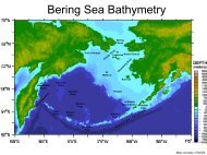
ALPHA HELIX CRUISE <strong>HX235</strong>Friday 25th August <strong>2000</strong> - Thursday 7th September <strong>2000</strong>BERING STRAIT CRUISE REPORTFUNDING SOURCE:CHIEF SCIENTIST:NSF-OPP-9815707 (Kelly Falkner, OSU)Rebecca Woodgate<strong>University</strong> <strong>of</strong> Washington, Applied Physics Laboratory1013 NE 40th StreetSeattle, WA 98105-6698.Phone: 206-221-3268Fax: 206-616-3142Email: woodgate@apl.washington.eduSCIENTIFIC PERSONNEL:Rebecca WoodgateTerry WhitledgeDale HubbardAPL, MooringsUAF, Nutrients & SamplerOSU, Water SamplerSCIENTIFIC PURPOSE:This cruise has two scientific goals.The first (and foremost) is the recovery and redeployment <strong>of</strong> two moorings (A2 and A3) inthe <strong>Bering</strong> <strong>Strait</strong>. These moorings are part <strong>of</strong> a multi-year time-series (currently over 10years long) <strong>of</strong> measurements <strong>of</strong> the flow through the <strong>Bering</strong> <strong>Strait</strong>. The properties <strong>of</strong> thisflow not only influence the Chukchi and Beaufort Seas, but can also be traced across theArctic to the Fram <strong>Strait</strong> and beyond. The long-term monitoring <strong>of</strong> the inflow into the ArcticOcean via the <strong>Bering</strong> <strong>Strait</strong> is important for understanding climatic change both locallyand in the Arctic.The moorings carry conventional instrumentation - current meters (RCM), temperatureand salinity sensors (SBE16) and Upward-Looking-Sonars (ULS) - and new prototypeinstruments - either a water sampler (MITESS) or a nutrient sampler. The current metersand ULSs allow the quantification <strong>of</strong> the movement <strong>of</strong> ice and water through the strait.The prototype water sampler (OSU), designed to take in situ water samples throughoutthe year-long deployment, is to be recovered. The prototype nutrient sampler (UAF),designed to take in situ nutrients measurements, is to be deployed on the new northernmooring. These prototype instruments are valuable new technology which should greatlyenhance our ability to make year-long in situ measurements and significantly advance ourunderstanding <strong>of</strong> the system in the strait.The second aim <strong>of</strong> the cruise is to conduct a CTD, chemistry and ADCP survey <strong>of</strong> the<strong>Bering</strong> <strong>Strait</strong> and the southern part <strong>of</strong> the Chukchi Sea, concentrating on sections in thevicinity <strong>of</strong> the moorings and the region north <strong>of</strong> the mooring sites. The hydrographic casts(CTD and chemistry) will be used to calibrate the moored instruments and to give aframework for the analysis <strong>of</strong> the data. Where possible, the hydrographic lines will berepeats <strong>of</strong> sections from previous years, thus allowing an interannual comparison.1September <strong>2000</strong>
CRUISE SUMMARY:Despite high winds and rough conditions for most <strong>of</strong> the 13-day cruise, a mild weatherwindow in the <strong>Bering</strong> <strong>Strait</strong> and Chukchi region allowed us to complete the main cruiseobjectives (the mooring recoveries and deployments) and to sample and extend almostall <strong>of</strong> the proposed CTD lines. Since forecast bad weather made it imprudent to up to themost northerly CTD line, we instead extended the CTD line in the northern <strong>Bering</strong> <strong>Strait</strong>and ran additional stations in the <strong>Bering</strong> <strong>Strait</strong> section and both on route to and on returnfrom the working area. In addition, we took CTD casts for primary productivity at bothmooring sites and were able to sample in a coccolithophorid bloom, which we encounteredon the transits to and from the work area.CRUISE SCHEDULE:25 th August Sail from Seward 9.20amCTD casts at Res2.5 and Gak126 th August Transit to <strong>Bering</strong> <strong>Strait</strong>27 th August Transit to <strong>Bering</strong> <strong>Strait</strong>28 th August Transit to <strong>Bering</strong> <strong>Strait</strong>29 th August Transit to <strong>Bering</strong> <strong>Strait</strong>30 th August Transit to <strong>Bering</strong> <strong>Strait</strong>31 st August Starting at first light, recover A2-99, CTD, deploy A2-00Steam to A3, recover A3-99, CTD, deploy A3-99Run first 7 stations <strong>of</strong> A3L CTD lineRun ADCP line back down to A3 & to the start <strong>of</strong> the CHUK line1 st September Run CHUK line (10 CTD stations) & EEXT (3 CTD casts)ADCP back to the east end <strong>of</strong> the A3L lineComplete the A3L line, with a repeat <strong>of</strong> station 72 nd September Complete ADCP <strong>of</strong> A3L line, and half <strong>of</strong> CHUK lineTurn S before end <strong>of</strong> CHUK line to be at A3 for c.9am ship timePrimary Productivity station (A3L-A) at A3Run NBS line (14 CTD casts, extended to east)ADCP back along NBS line3 rd September ADCP along BSL line west to eastRun BSL line (6 CTD casts, plus 3 extra stations) back to westPrimary Productivity station (A2P) at A2 at c.9am ship timeADCP back to east end <strong>of</strong> BSL lineSteam for Dutch Harbor4 th September Transit to Dutch Harbor5 th September Transit to Dutch HarborCTD cast in coccolithophorid bloom at mooring site M46 th September Transit to Dutch Harbor (due to arrive 6 th /7 th September)MOORING WORK:Given the fair weather window in <strong>Bering</strong> <strong>Strait</strong>, the mooring operations were performedwithout a hitch on 31 st August. Both recoveries were on the stated positions. A2appeared on the single-beam echo sounder. A3 did not. We did not however search for itafter the initial pass. The omnidirectional echosounder failed to find A2. In this shallowwater (55m), the bottom echos drown out any signal. Releases functioned well. Bothmoorings were in good condition with moderate fouling, acorn barnacles and hydriods.Current meters and Seacats functioned well. Of the ULSs, only one would communicate2September <strong>2000</strong>
on the ship and neither would download. Of the twelve separate units in the water sampler,only five <strong>of</strong> the units would communicate. Of these, three samples had tight lids,although two <strong>of</strong> these samples contained bubbles. Both the ULSs and the water samplerwill be further investigated after the cruise.The deployments went smoothly. For future deployments, note that the nutrient analyzerhas extra chemical bags taped to the outside <strong>of</strong> the instrument and would be betterdeployed without the mooring being towed to the mooring site. For the second deployment,the automatic release hook on the deep trawl wire only released on the secondattempt.Table 1 gives details <strong>of</strong> the moorings. Preliminary time series are included in an appendix.HYDROGRAPHIC WORK:In total, 53 hydrographic casts were taken (Table 2, Figure 1). The first 2 stations (Res2.5and Gak1) are part <strong>of</strong> a multiyear time series which is always sampled on leavingSeward. Calibration CTD casts (A2-99 and A3-99) were run at both mooring sitesbetween recovery and deployment. The A3L line was run immediately subsequent to thedeployment at A3. Bad weather prevented the completion <strong>of</strong> the line in one run. The secondsection sampled was the CHUK line, followed by the EEXT line, and the remainder <strong>of</strong>the A3L line (with a 1 station overlap for comparison). ADCP lines were run either directlybefore or directly after the CTD sections, generally at 7 knots. A primary production cast(A3L-A) was performed at A3 at c.9 am ship time, just before local noon. The NBS linewas run that afternoon, and was extended further towards the coast. The BSL was runthe next morning, with a higher station spacing at the western end <strong>of</strong> the line than theoriginal plan. A final primary productivity cast (A2P) was taken at A2, again at c.9amship time. (Note lines have been renamed from the original cruise plan, to avoid confusionwith pre-existing sections.). On route to Dutch Harbor, a final opportunistic cast wasmade at the site <strong>of</strong> a mooring M4 near the Pribil<strong>of</strong> Islands, within a coccolithophoridbloom which was also observed on transit north to the <strong>Bering</strong> <strong>Strait</strong>.At each cast (except the primary productivity stations), up to 9 bottles were fired atapproximate depths <strong>of</strong> surface, 5m, 10m, and then at 10m intervals, bottom –2m and bottom.On only one occasion did a bottle fail to close. Duplicate salinity samples weretaken in an homogeneous layer at c. every other cast for later CTD calibration. After theA3L line, new caps were used on each salinity sample and upcasts were routinely stored,although the CTD was heaved at 60m/min, so the resolution may be poor. O18 samplesand Barium samples (including some doubles) were taken at all hydrocasts, except forRes2.5, Gak1, A2-99, station 8 on A3L, the NBS section, the extra stations added to theBSL, the primary productivity stations and the coccolithophorid station. A salinity samplewas taken from all bottles sampled for O18 and Barium to ensure the bottle closed correctlyand did not leak. In total, 200 O18 and 200 Barium samples were taken. Nutrientsamples were taken from all bottles except the NBS line, and on the BSL line where only3 depths were sampled. Chlorophyll samples were taken at the surface on the A3L andCHUK lines and at all depths at the two primary productivity stations. Nutrients were runon board. O18 and Barium samples will be shipped back to OSU for analysis.Preliminary CTD sections are included in an appendix.3September <strong>2000</strong>
TABLE 1: MOORING POSITIONS AND INSTRUMENTATIONIDLATITUDE(N)LONGITUDE(W)WATERDEPTH /mMETER orSAMPLERINST.DEPTH/mSAMPLEINTE<strong>RV</strong>ALRecoveredA2-99 65˚ 46.713' 168˚ 34.751' 55 (corr.) ULS 42 5minRCM7 46 1 hourSBE16 47 1hourA3-99 66˚ 19.71' 168˚ 58.10' 58 (corr.) ULS 46 5minRCM7 49 1hourSBE16 50 1hourWatersampler52 1 monthDeployedA2-00 65˚ 46.729' 168˚ 34.766' 55 (corr.) ULS 42 5minRCM7 46 1hourSBE16 47 30minA3-00 66˚ 19.66' 168˚ 58.00' 58 (corr.) ULS 48 5minRCM7 51 1hourSBE16 52 30minNutrientsampler54 6hoursTABLE 2: CTD casts:4September <strong>2000</strong>
StationNumberStationnameDateTime(GMT)Latitude(N)Longitude(-ve = W)Bottomdepth /mMaxpressure/dbar1 RES2.5 <strong>2000</strong>-08-25 18:03 60.0245 -149.359 295 2952 GAK1 <strong>2000</strong>-08-25 19:22 59.8440 -149.467 270 2663 A2-99 <strong>2000</strong>-08-31 16:13 65.7805 -168.576 52 534 A3-99 <strong>2000</strong>-08-31 20:48 66.3306 -168.970 54 545 A3L-2 <strong>2000</strong>-09-01 01:12 66.3583 -168.814 53 536 A3L-3 <strong>2000</strong>-09-01 02:21 66.3832 -168.669 55 567 A3L-4 <strong>2000</strong>-09-01 03:17 66.4079 -168.505 51 548 A3L-5 <strong>2000</strong>-09-01 04:18 66.4357 -168.313 45 489 A3L-6 <strong>2000</strong>-09-01 05:18 66.4711 -168.107 25 2810 A3L-7 <strong>2000</strong>-09-01 06:02 66.4968 -167.948 21 2611 CHUK1 <strong>2000</strong>-09-01 14:53 66.8162 -168.967 44 4312 CHUK2 <strong>2000</strong>-09-01 15:40 66.8000 -168.764 39 4213 CHUK3 <strong>2000</strong>-09-01 16:27 66.7831 -168.564 30 3114 CHUK4 <strong>2000</strong>-09-01 17:11 66.7664 -168.364 30 3215 CHUK5 <strong>2000</strong>-09-01 17:59 66.7493 -168.130 29 3016 CHUK6 <strong>2000</strong>-09-01 18:40 66.7329 -167.946 27 2817 CHUK7 <strong>2000</strong>-09-01 19:21 66.7173 -167.762 27 2918 CHUK8 <strong>2000</strong>-09-01 20:20 66.6927 -167.463 29 3119 CHUK9 <strong>2000</strong>-09-01 21:17 66.6676 -167.173 33 3420 CHUK10 <strong>2000</strong>-09-01 21:59 66.6510 -166.996 31 3121 EEXT-1 <strong>2000</strong>-09-01 22:53 66.6261 -166.730 29 3022 EEXT-2 <strong>2000</strong>-09-01 23:33 66.6111 -166.563 23 2423 EEXT-3 <strong>2000</strong>-09-02 00:39 66.5840 -166.198 15 1724 A3L-10 <strong>2000</strong>-09-02 04:06 66.6226 -167.155 31 3125 A3L-9 <strong>2000</strong>-09-02 05:04 66.5777 -167.422 27 3026 A3L-8 <strong>2000</strong>-09-02 06:09 66.5292 -167.713 23 2527 A3L-7 <strong>2000</strong>-09-02 07:01 66.4947 -167.948 22 2328 A3L-A <strong>2000</strong>-09-02 17:38 66.3352 -168.964 54 545September <strong>2000</strong>
29 NBS-1 <strong>2000</strong>-09-02 20:23 66.0011 -168.964 51 5130 NBS-2 <strong>2000</strong>-09-02 20:51 66.0015 -168.828 51 5231 NBS-3 <strong>2000</strong>-09-02 21:17 66.0010 -168.689 52 5232 NBS-4 <strong>2000</strong>-09-02 21:43 66.0013 -168.552 53 5333 NBS-5 <strong>2000</strong>-09-02 22:11 66.0016 -168.414 55 5534 NBS-6 <strong>2000</strong>-09-02 22:39 66.0021 -168.275 51 5235 NBS-7 <strong>2000</strong>-09-02 23:07 66.0019 -168.138 45 4636 NBS-8 <strong>2000</strong>-09-02 23:35 66.0021 -167.998 32 3237 NBS-9 <strong>2000</strong>-09-02 23:53 66.0007 -167.917 20 2038 NBS-10 <strong>2000</strong>-09-03 00:11 66.0009 -167.852 9 1039 NBS-11 <strong>2000</strong>-09-03 01:00 65.9998 -167.666 15 1640 NBS-12 <strong>2000</strong>-09-03 01:32 65.9999 -167.483 17 1841 NBS-13 <strong>2000</strong>-09-03 02:06 66.0008 -167.299 14 1542 NBS-14 <strong>2000</strong>-09-03 02:32 66.0004 -167.164 10 1343 BSL-6 <strong>2000</strong>-09-03 12:24 65.6849 -168.180 26 2744 BSL-5 <strong>2000</strong>-09-03 12:56 65.6979 -168.323 51 5145 BSL-4 <strong>2000</strong>-09-03 13:34 65.7139 -168.466 51 5246 BSL3B <strong>2000</strong>-09-03 14:00 65.7190 -168.539 54 5647 BSL3 <strong>2000</strong>-09-03 14:21 65.7264 -168.614 49 5048 BSL2.5 <strong>2000</strong>-09-03 14:44 65.7315 -168.681 49 5049 BSL2 <strong>2000</strong>-09-03 15:05 65.7366 -168.748 50 5150 BSL1.5 <strong>2000</strong>-09-03 15:27 65.7480 -168.810 49 5151 BSL1 <strong>2000</strong>-09-03 15:45 65.7571 -168.868 41 4252 A2P <strong>2000</strong>-09-03 17:16 65.7831 -168.580 52 5253 M4 <strong>2000</strong>-09-05 21:32 57.8548 -168.865 70 706September <strong>2000</strong>