(Final) Sept 2012 in PDF format - Carlisle City Council
(Final) Sept 2012 in PDF format - Carlisle City Council
(Final) Sept 2012 in PDF format - Carlisle City Council

You also want an ePaper? Increase the reach of your titles
YUMPU automatically turns print PDFs into web optimized ePapers that Google loves.
This document is was produced by EconomicDevelopment at <strong>Carlisle</strong> <strong>City</strong> <strong>Council</strong>. If you would likethis document <strong>in</strong> another <strong>format</strong>, for example largepr<strong>in</strong>t, braille, audio tape or another language, pleasecontact:Plann<strong>in</strong>g PolicyEconomic Development<strong>Carlisle</strong> <strong>City</strong> <strong>Council</strong>Civic Centre<strong>Carlisle</strong>CumbriaCA3 8QGemail: edadm<strong>in</strong>@carlisle.gov.ukTel: 01228 817000
What is a SHLAA?A Strategic Hous<strong>in</strong>g Land Availability Assessment (SHLAA) is a key piece of evidence that willsupport and <strong>in</strong>form the production of the <strong>Carlisle</strong> Local Plan, as required by the National Plann<strong>in</strong>gPolicy Framework (NPPF). The SHLAA provides a catalogue of land that is considered to the havethe potential for hous<strong>in</strong>g development. It aims to identify suffi cient specifi c sites with the potentialto meet hous<strong>in</strong>g requirements up to and beyond the whole 15 year plan period.It is important to be clear that the SHLAA will not <strong>in</strong> itself allocate landfor hous<strong>in</strong>g development, and that sites identified <strong>in</strong> the SHLAA will notautomatically come forward for development, or be guaranteed plann<strong>in</strong>gpermission. Likewise, sites that have been ruled out of the SHLAA could still begranted permission should the Local Plann<strong>in</strong>g Authority consider it appropriateafter a more detailed assessment of a plann<strong>in</strong>g application.Many sites with<strong>in</strong> this document have been assessed before the NationalPlann<strong>in</strong>g Policy Framework, which has made it easier to ga<strong>in</strong> plann<strong>in</strong>gpermission for residential dwell<strong>in</strong>gs, was <strong>in</strong>troduced. In some cases, sites thathad previously been discounted could now be considered suitable for hous<strong>in</strong>g,particularly those with<strong>in</strong> rural areas or closely located to villages. The <strong>Council</strong>has attempted to make sure that assessments now mirror what would besupported <strong>in</strong> the NPPF; however the next review of the SHLAA shall aim to pickup any sites that may have been missed.The primary role of the SHLAA is as follows:• to identify sites with potential for hous<strong>in</strong>g;• to assess their hous<strong>in</strong>g potential;• to assess when they are likely to be developed.This version of the SHLAA is an update to the Roger Tym consultants report, which was publicallyconsulted on <strong>in</strong> June <strong>2012</strong>. In<strong>format</strong>ion with<strong>in</strong> the SHLAA has been updated <strong>in</strong> response tocomments received, however this document should still be read <strong>in</strong> conjunction with the consultantsreport.
Summary of f<strong>in</strong>d<strong>in</strong>gsThis version of the <strong>Carlisle</strong> SHLAA currently demonstrates enough deliverable and developableland to support 9,460 new houses over the 15 year plan period of the forthcom<strong>in</strong>g new Local Plan.A break down of this fi gure has been provided below.Urban Rural TotalTotal: 6,997 2,463 9,460Deliverable: 4,441 2,010 6,441Developable: 2,556 453 3,009Brownfi eld: 1,241 181 1,422Greenfi eld: 5,756 2,282 8,038In October 2011 <strong>Carlisle</strong> <strong>City</strong> <strong>Council</strong> consulted the public on the Issues and Options for the CoreStrategy. In this document a number of possible hous<strong>in</strong>g targets were presented for consideration.These targets ranged between 400 and 650 new dwell<strong>in</strong>gs to be built each year with<strong>in</strong> the district,a total of 6,000 to 9,750 new dwell<strong>in</strong>gs over the 15 year span of the new Local Plan.As the table above shows, the lower target of 400 new homes per annum can easily beaccommodated on the land identifi ed <strong>in</strong> the SHLAA. However, the table also shows that availableland falls just short of meet<strong>in</strong>g the larger 650 new homes per annum target. If the <strong>Council</strong> elects topursue the larger target, more land will have to be identifi ed to accommodate it.Land identifi ed <strong>in</strong> the SHLAA currently shows a split of 74% of capacity be<strong>in</strong>g located with<strong>in</strong>the <strong>Carlisle</strong> urban area and 26% available <strong>in</strong> the rest of the district. It also highlights the limitedavailability of previously developed land suitable for hous<strong>in</strong>g, with only 15% of sites be<strong>in</strong>gconsidered ‘brownfi eld’ compared to 85% considered ‘greenfi eld’.
The local contextThe impend<strong>in</strong>g revocation of Regional Spatial Strategies and the associated hous<strong>in</strong>g targets,and <strong>in</strong> advance of a locally determ<strong>in</strong>ed hous<strong>in</strong>g target, raises the emphasis of the importance ofassess<strong>in</strong>g hous<strong>in</strong>g issues at the local level. The wider economic climate has also changed. In thelight of these changes the <strong>Council</strong> will work towards deliver<strong>in</strong>g a level of hous<strong>in</strong>g to meet needsand aspirations locally. The SHLAA shall be used to assess whether there is the physical capacitywith<strong>in</strong> the district to accommodate and locally derived hous<strong>in</strong>g targetsThe recent pattern of hous<strong>in</strong>g developmentThe chart above shows the number of completions for <strong>Carlisle</strong> District over 12 years. There was asudden decl<strong>in</strong>e <strong>in</strong> the number of new dwell<strong>in</strong>gs <strong>in</strong> 2006/07. It was envisaged that a slower rate ofdevelopment would be undertaken <strong>in</strong> 2008/09 and this is refl ected by the lower completion rates.S<strong>in</strong>ce the 08-09 report<strong>in</strong>g year the economy has cont<strong>in</strong>ued <strong>in</strong> recession with the po<strong>in</strong>t of leasthouse build<strong>in</strong>g so far reported <strong>in</strong> 09-10. The number of new dwell<strong>in</strong>gs does now seem to be on theupturn with latest fi gures suggest<strong>in</strong>g a return to pre 06-07 completion rates; however it may be tooearly to say whether this will be susta<strong>in</strong>ed <strong>in</strong> com<strong>in</strong>g years.The average for the district 5-year trend for completions is:urban area average – 239 per annumrural area average – 93 per annumdistrict average – 332 per annum
STAGE 2: Determ<strong>in</strong><strong>in</strong>g which sources of sites will be <strong>in</strong>cluded <strong>in</strong> theassessmentThe follow<strong>in</strong>g sources of sites with potential have been <strong>in</strong>cluded <strong>in</strong> the search for sites.Sites <strong>in</strong> the plann<strong>in</strong>g process• land allocated (or with permission) for employment or other land uses which is no longerrequired for those uses• exist<strong>in</strong>g hous<strong>in</strong>g allocations and site development briefs• unimplemented/outstand<strong>in</strong>g plann<strong>in</strong>g permissions for hous<strong>in</strong>g• plann<strong>in</strong>g permissions for hous<strong>in</strong>g that are under construction – that are unlikely to becompleted by the time the Local Plan is adoptedSites not currently <strong>in</strong> the plann<strong>in</strong>g process• vacant and derelict land and build<strong>in</strong>gs• surplus public sector land• land <strong>in</strong> non-residential use which may be suitable for re-development for hous<strong>in</strong>g, such ascommercial build<strong>in</strong>gs or car parks, <strong>in</strong>clud<strong>in</strong>g as part of mixed-use development• additional hous<strong>in</strong>g opportunities <strong>in</strong> established residential areas, such as under-used garageblocks• large scale redevelopment and re-design of exist<strong>in</strong>g residential areas• sites <strong>in</strong> rural settlements and rural exception sites• urban extensionsCerta<strong>in</strong> areas were excluded and therefore have a nil hous<strong>in</strong>g potential. The excluded areas<strong>in</strong>clude Hadrian’s Wall Military Zone World Heritage Site, all designated SSSIs, and all greenfi eldsites <strong>in</strong> the undeveloped open countryside, where not immediately adjacent to a settlement. Theundeveloped open countryside for the purposes of the SHLAA <strong>in</strong>cludes all land separated fromthe settlement boundaries of key and local service centres. It does not exclude developed land <strong>in</strong>smaller villages listed <strong>in</strong> Policy H1 of the adopted Local Plan, or sites immediately adjacent to thesettlement boundaries of local service centres. In addition, land with<strong>in</strong> the functional fl oodpla<strong>in</strong>,(Zone 3b) as identifi ed <strong>in</strong> <strong>Carlisle</strong>’s Strategic Flood Risk Assessment November 2011 has alsobeen excluded.The site threshold has been set at 0.4 hectares <strong>in</strong> order that the potential of small sites is notoverlooked, as they are a valuable source of cumulative potential. It is recognised that a range ofsmaller sites expands choice for both developers and landowners.
STAGE 3: Desktop review of exist<strong>in</strong>g <strong>in</strong><strong>format</strong>ionThe follow<strong>in</strong>g fi gure sets out the data sources that have been used to identify sites that may havepotential for hous<strong>in</strong>g, and any other relevant <strong>in</strong><strong>format</strong>ion such as constra<strong>in</strong>ts.Sites that have been identifi ed <strong>in</strong> stage 2 and 3 have been entered onto a database and mapped.The database records standard <strong>in</strong><strong>format</strong>ion for each site to assist <strong>in</strong> site assessment. The<strong>in</strong><strong>format</strong>ion <strong>in</strong>cludes the follow<strong>in</strong>g:• general description of the site, its surround<strong>in</strong>gs and its boundaries;• topography of the site;• access to services;• current use;• Constra<strong>in</strong>ts such as watercourse, electricity pylons etc;• assessment of its suitability and potential for hous<strong>in</strong>g, <strong>in</strong>clud<strong>in</strong>g a timescale.Sources of <strong>in</strong><strong>format</strong>ionSites <strong>in</strong> the plann<strong>in</strong>g processPurposeSite allocations not yet the subject of plann<strong>in</strong>g To identify sitespermissionPlann<strong>in</strong>g permissions/sites under construction To identify sites(particularly those be<strong>in</strong>g developed <strong>in</strong> phases)Site specifi c development briefsTo identify sites and any constra<strong>in</strong>ts to deliveryPlann<strong>in</strong>g application refusals, and expired To identify sites – site threshold of 0.4 hectaresplann<strong>in</strong>g permissions.applies. Records for last three years searched.Dwell<strong>in</strong>g starts and completion records To identify the current development progresson sites with plann<strong>in</strong>g permissionOther sources of <strong>in</strong><strong>format</strong>ion that may help to identify sitesCall for sitesTo identify sites held by landowners/developers<strong>in</strong> the whole of the District.Local plann<strong>in</strong>g authority Urban Capacity Study To identify build<strong>in</strong>gs and land, and anyconstra<strong>in</strong>ts to deliveryNational Land Use DatabaseTo identify build<strong>in</strong>gs and land, and anyconstra<strong>in</strong>ts to deliveryRegister of Surplus Public Sector Land To identify build<strong>in</strong>gs and landLocal plann<strong>in</strong>g authority Employment Land To identify surplus employment build<strong>in</strong>gs andReviewlandCommercial property databases eg estate To identify vacant build<strong>in</strong>gs and landagents and property agentsOrdnance Survey mapsTo identify landAerial photographyTo identify land
STAGE 4: Determ<strong>in</strong><strong>in</strong>g which sites and areas will be surveyedIn addition, a comprehensive assessment of the Local and Key Service Centres <strong>in</strong> the ruralarea, (which are listed <strong>in</strong> Policy DP1 of the adopted Local Plan) was undertaken. This surveyassessed the capacity <strong>in</strong> both landscape and local service provision terms to accommodate furtherdevelopment, and identifi ed broad areas capable of absorb<strong>in</strong>g such development. In additionto this, particular areas of search <strong>in</strong>cluded those villages with<strong>in</strong> a two mile radius of <strong>Carlisle</strong>,regardless of the level of services they provide. These villages often provide a susta<strong>in</strong>ablelocation with good public transport connections, and are more likely to give rise to walk<strong>in</strong>g orcycl<strong>in</strong>g trips to the city.A m<strong>in</strong>imum site size of 0.4 hectares has been set, and most sites under this threshold wereexcluded from the survey. All the sites that were submitted under the Call for Sites processwere visited, whilst sites identifi ed from other sources were only visited if suffi cient up-to-date<strong>in</strong><strong>format</strong>ion was lack<strong>in</strong>g.STAGE 5: Carry<strong>in</strong>g out the surveyThe aim of the survey is to look at the sites identifi ed as part of the SHLAA to see if they aresuitable to accommodate the level of new homes needed <strong>in</strong> the district over the next 15 years.This level will be set with<strong>in</strong> the forthcom<strong>in</strong>g new Local Plan.Whilst some of the sites were <strong>in</strong> suitable locations, many confl icted with susta<strong>in</strong>ability objectivesand with national and local plann<strong>in</strong>g policies. An <strong>in</strong>itial assessment of suitability was made at thisstage, and the stakeholder panel consulted with the specifi c <strong>in</strong>tention of identify<strong>in</strong>g site constra<strong>in</strong>tsand how they could be overcome. In<strong>format</strong>ion used by the <strong>Council</strong> at this stage also <strong>in</strong>cludedthe Local Plan proposals map, Cumbria Biodiversity Evidence Base and the Strategic Flood RiskAssessment 2011. Cumbria County <strong>Council</strong> also provided <strong>in</strong>put with data on landscape character,biodiversity, education, social care, transport and the historic environment.STAGE 6: Assessment of hous<strong>in</strong>g potentialThe National Plann<strong>in</strong>g Policy Framework (NPPF) states that density standards on hous<strong>in</strong>gdevelopments should be set locally, ensur<strong>in</strong>g land is used effi ciently and susta<strong>in</strong>ably. With<strong>in</strong>urban areas there will be opportunities to achieve higher densities than <strong>in</strong> the rural areas, and,where appropriate, higher densities close to the city centre.Density is a measure of the number of dwell<strong>in</strong>gs that can be built on a site. In undertak<strong>in</strong>g theassessment of hous<strong>in</strong>g potential, the density of exist<strong>in</strong>g development around sites did not directly<strong>in</strong>fl uence the assessment.Certa<strong>in</strong> sites have development constra<strong>in</strong>ts on them which limit density, for example mature trees,topography or watercourses.Lower density suburban type family hous<strong>in</strong>g rema<strong>in</strong>s popular. However, with<strong>in</strong> <strong>Carlisle</strong> overthe last fi ve years, a signifi cant proportion of new development has been high density one ortwo bedroom fl ats. These do not meet family needs, and do not always contribute to the needto provide mixed and balanced communities. A balance therefore needs to be struck. Thequalities of good suburban hous<strong>in</strong>g can be designed <strong>in</strong> to higher density schemes, provided thatthe development is <strong>in</strong>tegrated <strong>in</strong>to the exist<strong>in</strong>g surround<strong>in</strong>g hous<strong>in</strong>g area. At present with<strong>in</strong> theDistrict, evidence suggests that there is a shortage of larger family homes. The hous<strong>in</strong>g type andmix on a site will be guided by emerg<strong>in</strong>g plann<strong>in</strong>g policy and agreed at plann<strong>in</strong>g application stage.
Site achievability has been used as a key factor to decide whether a site is deliverable with<strong>in</strong> 5years of Local Plan adoption or developable and more likely to come forward with<strong>in</strong> the later 6-15years of the plan period. Sites have not been discounted on viability assessments alone as, giventhe current diffi cult economic climate, it was not considered justifi ed to rule out possible upturns <strong>in</strong>the market over the next 15 years. Unviable, but otherwise suitable, sites were therefore classedas developable and pushed towards the later end of the plan period.Overcom<strong>in</strong>g constra<strong>in</strong>tsWhere constra<strong>in</strong>ts have been identifi ed, an assessment has been made of what actions would beneeded to remove them, and whether such actions are feasible. Where constra<strong>in</strong>ts have beenidentifi ed as be<strong>in</strong>g a barrier to development, the site has been rejected.Monitor<strong>in</strong>g and ReviewThe SHLAA is not a one-off study, and updat<strong>in</strong>g it through the addition of new sites will be part ofa roll<strong>in</strong>g programme and an <strong>in</strong>tegral part of the Annual Monitor<strong>in</strong>g Report process.
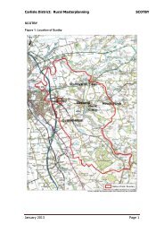
Settlement MapsThe follow<strong>in</strong>g pages provide a series of maps show<strong>in</strong>g SHLAA sites as they are located with<strong>in</strong> thevarious settlements of the district. Only those settlements conta<strong>in</strong><strong>in</strong>g deliverable or developableSHLAA sites have been <strong>in</strong>cluded. Maps show<strong>in</strong>g discarded sites are available on the <strong>Council</strong>’swebsite (www.carlisle.gov.uk) or on request by call<strong>in</strong>g 01228 817192.Sites have been colour coded to <strong>in</strong>dicate whether or not they are considered to be deliverable, andtherefore likely to come forward with<strong>in</strong> the fi rst 5 years of the plan period, or developable and morelikely to come forward with<strong>in</strong> the fi nal 6 – 15 years of the plan period. Sites are coloured as follows:: Deliverable (0-5 Years after Local Plan adoption): Developable (6-15 Years after Local Plan adoption)The follow<strong>in</strong>g license applies to each image:©Crown copyright and database rights <strong>2012</strong> Ordnance Survey LA100024459
Appendix A: Deliverable SitesRef Site Street Settlement Area(Ha)DeliverableCapacityDevelopableCapacityType CommentBR01 Land North ofOld Church LaneBR03 Land Adj GarthHouseOld ChurchLaneBR06 Garth House Greenfi eldLaneBR07 Land Adj GeltRiseBR08 Land West ofK<strong>in</strong>gswaterCloseBrampton 6.21 168 GreenDacre Road Brampton 5.66 153 Green Right of way must be reta<strong>in</strong>ed with<strong>in</strong> developmentBrampton 1.24 6 Green high value gardens now open to public, would needto be reta<strong>in</strong>ed to protect character of listed build<strong>in</strong>gGelt Road Brampton 0.76 25 GreenGreenhill Brampton 2.13 62 Green Right of way across site would need to be reta<strong>in</strong>edBR11 Land at Elmfi eld Brampton 13.63 300 100 GreenOC33 Adjacent to CroftHouseCA03 New HouseFarmCA07 Land at GardenVillageCA08 Land/Property atBurgh RoadCA14 Former BelahSchoolCA24 land at W<strong>in</strong>dsorWayCA23 Land to the rearof Farbrow RoadCA34 Land adjHammonds PondCA35 Land at GardenVillageCA37 Land adj HebdenAveCA39 Land atGreymoorhillNewbyWestWigtonRoadBurnstock 0.75 4 Green Likely acceptable under NPPF<strong>Carlisle</strong> 24.6 358 Green<strong>Carlisle</strong> 3.15 77 GreenBurgh Road <strong>Carlisle</strong> 4.05 66 GreenEden Street <strong>Carlisle</strong> 2.72 59 Green Part of site has permission for GP surgery, rest isstill suitableW<strong>in</strong>dsorWayCumwh<strong>in</strong>tonRoadDurdarRoadWigtonRoad<strong>Carlisle</strong> 10.58 266 Green<strong>Carlisle</strong> 5.77 156 Green<strong>Carlisle</strong> 11.09 240 Green<strong>Carlisle</strong> 1.9 62 GreenHebden Ave <strong>Carlisle</strong> 5.59 151 GreenA7 <strong>Carlisle</strong> 8.03 217 Green Park and Ride Schemes have not been well used,the loss of this allocation is not considered to be acritical constra<strong>in</strong>t
CA40 Land at HighCr<strong>in</strong>dledykeFarmCA41 Land at Carleton CarletonRoadCA47 Land at Sta<strong>in</strong>tonRoadCr<strong>in</strong>dledyke <strong>Carlisle</strong> 29.23 300 650 GreenSta<strong>in</strong>tonRoad<strong>Carlisle</strong> 1.47 48 Green<strong>Carlisle</strong> 4.6 124 Green Unlikely that whole of site would be developedCA50 Middle Farm Cr<strong>in</strong>dledyke <strong>Carlisle</strong> 27.84 300 GreenCA60 Land at BeverleyRiseCA68 Land at Sta<strong>in</strong>tonRoadHarraby <strong>Carlisle</strong> 17.33 299 Green Proximty of motorway may cause noise issues -screen<strong>in</strong>g requiredK<strong>in</strong>gmoorRoadCA70 Carleton Cl<strong>in</strong>ic (FormerGarlandsSite)CA27E Land at Garlands Cumwh<strong>in</strong>tonRoadCA72 Durranhill DurranhillRoadCA09A Property atPortland SquareCA09B Property atPortland SquareCA09C Property atPortland SquareCA09D Property atPortland SquareCA09E Property atPortland SquareCA10 Land at YorkGardensCA11 Former NorthCumbriaTechnologyCollegeCA12 Former MortonPark PrimarySchoolPortlandSquarePortlandSquarePortlandSquarePortlandSquarePortlandSquare<strong>Carlisle</strong> 3.9 63 Green<strong>Carlisle</strong> 4.24 114 Brown<strong>Carlisle</strong> 10.85 267 Green<strong>Carlisle</strong> 4.75 49 Green Once legal agreement has been signed, site will nolonger be appropriate for the SHLAA<strong>Carlisle</strong> 0.14 7 Brown Very small site not of strategic value, Site has been<strong>in</strong> residential use <strong>in</strong> the past<strong>Carlisle</strong> 0.05 3 Brown Very small site not of strategic value, Site has been<strong>in</strong> residential use <strong>in</strong> the past<strong>Carlisle</strong> 0.08 4 Brown Very small site not of strategic value, Site has been<strong>in</strong> residential use <strong>in</strong> the past<strong>Carlisle</strong> 0.1 6 Brown Very small site not of strategic value, Site has been<strong>in</strong> residential use <strong>in</strong> the past<strong>Carlisle</strong> 0.04 2 Brown Very small site not of strategic value, Site has been<strong>in</strong> residential use <strong>in</strong> the pastUpperby <strong>Carlisle</strong> 11.55 49 Green Some limited development of site my securefund<strong>in</strong>g for upgrad<strong>in</strong>g recreational amenityEdgehillRoad<strong>Carlisle</strong> 9.22 174 BrownBurnrigg <strong>Carlisle</strong> 1.67 54 Brown
CA20 Land at VictoriaPlaceCA22 Land Adj toCr<strong>in</strong>dledykeEstateCA25 South WesternTerraceVictoriaPlaceCA64 Hilltop Heights LondonRoadCA71 Land off WigtonRoadCA49 Land at NelsonStreetCA63 Former Pengu<strong>in</strong>FactoryCA69 <strong>Carlisle</strong>RacecourseCA71a Allocation atMorton<strong>Carlisle</strong> 0.48 17 BrownCr<strong>in</strong>dledyke <strong>Carlisle</strong> 4.86 131 GreenCurrock <strong>Carlisle</strong> 3.11 82 BrownWigtonRoadNelsonStreetDurdarRoad<strong>Carlisle</strong> 1.17 31 Green Deisgn will be of key importance for anydevelopment on this site as it will be highly visible<strong>Carlisle</strong> 8.78 200 Green<strong>Carlisle</strong> 2.84 85 Brown Offi ce build<strong>in</strong>g on part of site to be reta<strong>in</strong>ed forcont<strong>in</strong>ued use by owner<strong>Carlisle</strong> 0.7 38 Brown<strong>Carlisle</strong> 1.24 42 Brown Full permission and likely grant fund<strong>in</strong>g suggest siteis deliverablePeter Lane <strong>Carlisle</strong> 29.4 300 525 GreenOC07 Land atBuckabankCUD01 Land AdjGarthsideCUD03 Land off CaldewRoadDalston <strong>Carlisle</strong> 2.86 15 Green Likely to be acceptable under NPPF - support<strong>in</strong>gDalston servicesCaldewRoadCummersdale 0.38 14 Green Similar sized sites <strong>in</strong> villages close to <strong>Carlisle</strong> havebeen classed as achievable. No major constra<strong>in</strong>tson this site to make it unviable.Cummersdale 0.58 19 Green Similar sized sites <strong>in</strong> villages close to <strong>Carlisle</strong> havebeen classed as achievable. No major consCUW01 Newlands Farm Cumwh<strong>in</strong>ton 0.24 9 Green Once approval is signed off this site will no longerbe appropriate for the SHLAACUW02 Land to the rearof The ChapelDA01 Land atTownhead RoadDA03 Land betweenTownhead Roadand Station RoadGI01 Land/Property atThe Bridge InnCrakegarthCloseTownheadRoadCumwh<strong>in</strong>ton 0.76 25 GreenDalston 5.23 85 GreenDalston 5.57 150 GreenGilsland 0.28 6 Brown Flood risk will be a constra<strong>in</strong>t
HO01 Land north ofHoughtonHO03 Hadrians Camp HoughtonRoadHO02 Land atHoughton RoadHoughtonRoadHoughton 7.66 62 GreenHoughton 28.6 124 Brown not all of site will be developable due to scale andwildlife concernsHoughton 4.16 22 GreenOC31 South Ellengrove L<strong>in</strong>stock 3.24 10 Green Not yet estblished whether L<strong>in</strong>stock will be allowedgrowth <strong>in</strong> the Local Plan. Future policy may rule thissite out. Scale of acceptable development <strong>in</strong> villagewill be limited.OC32 North Rose Dene L<strong>in</strong>stock 1.43 10 Green Not yet estblished whether L<strong>in</strong>stock will be allowedgrowth <strong>in</strong> the Local Plan. Future policy may rule thissite out. Scale of acceptable development <strong>in</strong> villagewill be limited.OC30 North Stile Farm L<strong>in</strong>stock 1.25 10 Green Not yet estblished whether L<strong>in</strong>stock will be allowedgrowth <strong>in</strong> the Local Plan. Future policy may rule thissite out. Scale of acceptable development <strong>in</strong> villagewill be limited.LO02 Land Adjo<strong>in</strong><strong>in</strong>gBriar BankLO03 Land BetweenMoor Rd & OldRdLO07 Land to theSouth ofScaurbankLO01 FormerLoch<strong>in</strong>var SchoolRO01 Land AdjRockcliffeMemorial HallRO02 Land at Lonn<strong>in</strong>gFootRO04 Land north ofRockcliffe SchoolOld Road Longtown 2.95 80 GreenMoor Road Longtown 7.08 153 GreenNetherbyRoadLongtown 1.76 46 GreenMary Street Longtown 5.04 136 Green New development should look to reta<strong>in</strong> sports fi eldand facilities if possibleRockcliffe 0.54 18 GreenRockcliffe 0.28 10 GreenRockcliffe 1.15 7 GreenSC02 Field at Hillhead Scotby 8.72 42 Green Oil Pipe runs through site - could be a signifi cantconstra<strong>in</strong>tSC04 Site OffBroomfallenRoadBroomfallenRoadScotby 1.5 49 Green
SC05 Land beh<strong>in</strong>dScotby VillageHallWB02 Corby Hill Road Corby Hill WarwickBridgeWE01 Land AdjWheatsheafGardensWE02 Land Adj Play<strong>in</strong>gFieldsWheatsheafGardensWheatsheafGardensScotby 1.71 56 Green2.19 36 Green Numbers limited due to landscape impact347881Wetheral 0.61 20 GreenWetheral 2.96 78 Green
Appendix B: Developable SitesRef Site Street Settlement Area (Ha) Capacity Type CommentOC49 Land adjacent toStone BankAglionby 0.59 13 Green Treatment works would need upgraded before thisbecomes deliverableOC48 Aglionby Grange Holme Lane Aglionby 0.42 3 Green Likely acceptable under NPPFBL01 Land to the East ofDurdar RoadBR04 Brampton InfantSchoolCA30 Land Adj to WestHouseCA31 Site at Dalston Road/Stanhope RoadDudar Road Blackwell 4.09 120 Green Data required from Highways and UU for full viabilityassessment. Site is occasionally used as overfl owcar park<strong>in</strong>g for racecourse.Moat Street Brampton 0.25 9 BrownWigton Road <strong>Carlisle</strong> 1.38 45 Green Only developable with CA7 and CA35Dalston Road <strong>Carlisle</strong> 2.43 38 BrownCA33C Land at Botchergate Botchergate <strong>Carlisle</strong> 0.23 7 Brown Some noise issues with surround<strong>in</strong>gsCA42 Former Dairy Hollywell Crescent <strong>Carlisle</strong> 1.51 49 Brown Loss of employment land needs to be taken <strong>in</strong>toaccountCA51 Depot at LondonRoadCA52 Former Head PostOffi ce (HPO)London Road <strong>Carlisle</strong> 1.99 64 Brown Signifi cant clearance costs likely on siteWarwick Road <strong>Carlisle</strong> 0.21 15 BrownCA54 Land at Greymoorhill K<strong>in</strong>gstown <strong>Carlisle</strong> 3.96 107 Green Only developable <strong>in</strong> conjuction with CA39CA56 Bousteads Grass<strong>in</strong>gDepotCA65 Land at HarrabyGreen RoadRome Street <strong>Carlisle</strong> 1.06 35 BrownHarraby GreenRoad<strong>Carlisle</strong> 1.61 16 Green Flood risk a major constra<strong>in</strong>t on siteCA67 St Nicholas K<strong>in</strong>g St <strong>Carlisle</strong> 0.2 7 Brown Site currently has permission for a hotel - this maymean it has to come out of the SHLAAOC17 South Western Edgeof <strong>Carlisle</strong>CA59 Amenity Land offWigton RoadCA61 Land Opp RosehillIndustrial Estate<strong>Carlisle</strong> 245 Green Broad area for development. Very long term.Westwood <strong>Carlisle</strong> 0.79 26 Green Only developable once new open space on adjacentdevelopment has been completed to off set loss ofcurrent amenity provisionDurranhill Road <strong>Carlisle</strong> 10.5 159 Green While this site is achievable, it is prudent to waitand review likelihood of employment developmentcom<strong>in</strong>g forward fi rstCA73 Land off Brisco Road Brisco Road <strong>Carlisle</strong> 10.85 391 Green This site has been extended from submission to<strong>in</strong>clude land to the north east
CA53 Land at Rome Street Rome Street <strong>Carlisle</strong> 3.42 98 Brown This site may have long term potentialOC18 Land at HarkerRoads EndHarker <strong>Carlisle</strong> 0.8 24 Green Site may have potential <strong>in</strong> the long term, particularlygiven it's proximity to <strong>Carlisle</strong> and site CA50, shouldCA50 be developedOC23 K<strong>in</strong>gmoor Park Harker <strong>Carlisle</strong> 10.59 300 Brown Employment use prov<strong>in</strong>g to be no longer viable.Hous<strong>in</strong>g development could be <strong>in</strong>vestment requiredto tidy the site upDU03 Land at Durdar Farm Durdar Road Durdar 3.9 30 Green Development would need to be limited to ensure siteis of appropriate scale for the villageOC35 Former Harker GardenCentreSC01 Land beh<strong>in</strong>d ScotbyRoadSC09 Land beh<strong>in</strong>d ScotbyRoadSM01 Land Adj Fir EndsSchoolWE03 Land Adj HallmoorCourtOC50 Land adjacent toWreay SchoolA7 Harker 1.29 42 Brown Part of site currently has permission for modularhome display centre but this has yet to beimplemented. Site may have potential for hous<strong>in</strong>g <strong>in</strong>the long termScotby Road Scotby 1.25 44 Green Currently no access, this would need to beovercomeScotby Road Scotby 1.35 40 Green Currently no access, this would need to beovercomeSmithfi eld 2.58 7 GreenWetheral 1.16 38 GreenWreay 1.16 7 Green Can only be considered deliverable if treatmentworks are expanded
Appendix C: Discarded SitesRef Site Street Settlement Area (Ha) CommentOC03 South View Farm Beaumont 1.09 Unsusta<strong>in</strong>able LocationBL02 Scuggar House Farm Blackwell 2.65 Poorly related to SettlementBR02 Land at The Grange Craw Hall Brampton 0.79 Physical and environmental constra<strong>in</strong>ts on siteBR05 The Irth<strong>in</strong>g Centre Union Lane Brampton 1.21 Important employment land that should be reta<strong>in</strong>edBR09 Land at the Grange Craw Hall Brampton 1.52 Physical and Envrionmental constra<strong>in</strong>ts on site - unacceptableharmful impact on the conservation areaOC11 Land at Quarry Bank Lane Capon Tree Hill Brampton 0.16 Unsusta<strong>in</strong>able Location, Site too small to be considered <strong>in</strong>SHLAAOC41 Field 2974 Station Road Brampton 0.66 Poorly related to settlement, access constra<strong>in</strong>tsBR12 Land at Ridge Vale Brampton 0.69 No visible means of access, poorly related to settlementOC37 Broad Area off A69 Brampton 33.43 Isolated. Unsusta<strong>in</strong>able locationBR10 Land off Edmondson Close Edmonson Close Brampton 9.61 Landscape impact, unsuitable topography, environmentalimpact, accessOC12 Land at Hawksdale Bridge Buckbank 3.1 Access constra<strong>in</strong>ts - Highways consider site unfeasibleCARG01 Adjacent to West End Farm Cargo 0.45 Poorly related to settlementOC44 Fairhaven Carleton 0.45 Poorly related to settlementOC46 Poplar House Carleton 6.48 Poorly related to settlement, Landscape impactCA45 Land adjacent to Carleton Farm Carleton Road Carleton 1.59 Waste water works and access phsyically constra<strong>in</strong> site mak<strong>in</strong>git unviableCA01 Mitchell Dryers Denton Holme <strong>Carlisle</strong> 1.03 Employment area not suitable for residential, with<strong>in</strong> Floodzone3aCA02 Riverside Way Greystone Road <strong>Carlisle</strong> 0.45 Floodrisk - despite fl ood defenses <strong>in</strong> the area past Inspector'sreport supported the deletion of this site from the Local PlanHous<strong>in</strong>g AllocationsCA04 Land at Denton Street Denton Street <strong>Carlisle</strong> 0.67 Employment Area not suitable for residential, with<strong>in</strong> Floodzone3aCA05 Land at Durranhill Durranhill <strong>Carlisle</strong> 11.67 Unlikely to ever be developableCA06 Land off California Road California Road <strong>Carlisle</strong> 2.34 Unsusta<strong>in</strong>able location, poor accessCA16 Land at Warwick Road Warwick Road <strong>Carlisle</strong> 3.2 With<strong>in</strong> river fl oodpla<strong>in</strong>CA19 Newfi eld Head Farm <strong>Carlisle</strong> 18.24 Would close important gap between Houghton and <strong>Carlisle</strong>CA26 Land at London Road London Road <strong>Carlisle</strong> 14.8 Constra<strong>in</strong>ts associated with the site mean that it is unlikely toever be developableCA27W Land at Garlands <strong>Carlisle</strong> 7.55 Landscape impactCA28 Land off Lorne Crescent Denton Holme <strong>Carlisle</strong> 0.45 Employment Area not suitable for residential, Floodzone 3a
CA29 Land at Moorhouse Road Moorhouse Road <strong>Carlisle</strong> 6.51 Overhead cables physically constra<strong>in</strong> site mak<strong>in</strong>g it unsuitablefor residential developmentCA33A Land at Botchergate Botchergate <strong>Carlisle</strong> 0.37 Employment Area not suitable for residentialCA33B Land at Botchergate Botchergate <strong>Carlisle</strong> 0.43 Employment Area not suitable for residentialCA33D Land at Botchergate Botchergate <strong>Carlisle</strong> 0.16 Employment Area not suitable for residentialCA43 Land at Knockupworth Farm Burgh Road <strong>Carlisle</strong> 20.3 Overhead cables physically constra<strong>in</strong> site mak<strong>in</strong>g it unsuitablefor residential developmentCA44 Land at Knockupworth Farm Burgh Road <strong>Carlisle</strong> 9.31 Overhead cables physically disconnect site from the built uparea of the city, site is therefore not suitable for developmentCA46 Crown Speciality Packag<strong>in</strong>g UKLtdJames Street <strong>Carlisle</strong> 0.96 Employment area not suitable for residential development, fl oodrisk, close proximity of SSSICA48 Land at Tarraby <strong>Carlisle</strong> 26.06 Landscape impact, would have unacceptable impact uponTarrabyCA55 Land at Dene Crescent Dene Crescent <strong>Carlisle</strong> 0.55 Unacceptable loss of important open spaceCA57 Cecil Street Car Park Botchergate <strong>Carlisle</strong> 0.53 Unacceptable loss of car parkCA66 4B Brunel Way Durranhill <strong>Carlisle</strong> 0.68 Located with<strong>in</strong> <strong>in</strong>dustrial estate - unlikely to ever be developableas hous<strong>in</strong>gOC05 Land off Peter Lane Peter Lane <strong>Carlisle</strong> 2.87 Unsusta<strong>in</strong>able LocationOC06 Land at Harker Harker <strong>Carlisle</strong> 11.36 Landscape ImpactOC07 Land at Buckabank Dalston <strong>Carlisle</strong> 2.86 Unsusta<strong>in</strong>able LocationOC14 Griershill Farm Harker <strong>Carlisle</strong> 26.21 Unsuitable location for residential development - <strong>in</strong> an area ofemployment use and adjacent to busy/noisy motorwayOC15 Toddhills <strong>Carlisle</strong> 15.82 Unsusta<strong>in</strong>able Location, not related to any establishedsettlementOC43 Land at Harker Harker <strong>Carlisle</strong> 1.01 Unsusta<strong>in</strong>able location, access constra<strong>in</strong>tsCA27C Land at Garlands Cumwh<strong>in</strong>ton Road <strong>Carlisle</strong> 4.5 Poorly related to settlement, landscape impactCA62 Key Safety Systems <strong>Carlisle</strong> 1.47 Site has permission for Student accomodation, construction wellunderwayCA36S Land south of Etterby Road Etterby Road <strong>Carlisle</strong> 0.95 Unsuitable topography, impact on SSSI/SAC, HighwayConstra<strong>in</strong>tsCA36N Land adj Etterby Road Etterby Road <strong>Carlisle</strong> 1.02 Site has permission - no longer suitable for SHLAACA13 Former HK Campbell School Raffl es Avenue <strong>Carlisle</strong> 0.89 Site has permission for 39 houses no longer suitable for SHLAAconstruction well underwayCA38 Land at Beaumont Road Beaumont Road <strong>Carlisle</strong> 2.28 Flood Zone 3BOC34 West of K<strong>in</strong>g Acre Corby Hill 1.85 Poorly related to settlement
OC36 K<strong>in</strong>gswood Educational StudyCentreGreensyke Cumdivock 2.47 Unsusta<strong>in</strong>able locationCUD02 Site at High Cummersdale Cummersdale 3.82 Poorly related to settlment, major access constra<strong>in</strong>tsCUW03 Land at Lyndhurst Cumwh<strong>in</strong>ton 0.52 Poorly related to settlement, access issuesCUW04 Land at Peter Gate Cumwh<strong>in</strong>ton 1.37 Poorly related to settlement, open space use should be reta<strong>in</strong>edOC01 Land near Graylands Aldby Cumwh<strong>in</strong>ton 0.51 Unsusta<strong>in</strong>able LocationDA02 Town Head Road Town Head Road Dalston 0.54 Poorly related to settlementDA04 Land at Dalston Dalston 1.73 Poorly related to settlementDU01 467 Durdar Road Durdar Road Dalston 5.8 Access issues, development of site would be detrimental to thecharacter of the villageDU02 445 Durdar Road Durdar Road Dalston 0.55 Poorly related to the settlement, developable part of the site toosmall to be considered strategicOC42 Ellers Mill Dalston 1.07 Currently <strong>in</strong> employment use with no <strong>in</strong>dication of change of usebe<strong>in</strong>g soughtOC04 Scuggar House Durdar 62.73 Poorly related to settlementOC28 Field No 4104 Fenton 3.73 Unsusta<strong>in</strong>able locationHA01 Bothy Cottage Hayton 0.37 Unsusta<strong>in</strong>able location, site too small to be considered strategicOC29 Low Allenwood Farm Broadwath Heads Nook 0.4 Unsusta<strong>in</strong>able locationHN01 Land adjacent to The Wh<strong>in</strong>s Heads Nook 2.62 Major highway constra<strong>in</strong>ts and utility constra<strong>in</strong>ts - access ontoma<strong>in</strong> road is not achievable without compromis<strong>in</strong>g highwaysafetyHN02 Land at Croftlands Cottages Heads Nook 0.42 Major utilities constra<strong>in</strong>ts - unlikely to see improved capacityOC10 Land at The Knells Houghton 1.82 Unsusta<strong>in</strong>able LocationOC38 Land at Townhead Houghton 0.31 Poorly related to settlementOC25 Adjacent to Yew Tree Farm Fenton How Mill 1.7 Unsusta<strong>in</strong>able locationOC27 Yew Tree Farm How Mill 2.38 Unsusta<strong>in</strong>able LocationOC24 The Old Station Warehouse Kirkandrewson Eden0.41 Unsusta<strong>in</strong>able locationLO04 Borders Bus<strong>in</strong>ess Park Longtown 7.78 Detached and poorly related to settlementLO05 Land at Netherby Road Netherby Road Longtown 6.88 Poorly related to settlementLO06 Land at Mill Street Mill Street Longtown 0.16 Too small to be considered stratgicOC16 Adjacent to Arthuret House Arthuret Road Longtown 4.38 Poorly related to settlementLR01 Carricks Yard Carricks Court Low Row 0.44 Unsusta<strong>in</strong>able LocationMO01 Monkhill Farm Monkhill 0.44 Unsusta<strong>in</strong>able location, on the course of Hadrian's WallOC47 Land at Orton Grange Orton Grange 1.03 Unsusta<strong>in</strong>able locationOC19 Factory Premises Haithwaite Penton 0.67 Unsusta<strong>in</strong>able location
OC22 Land adjacent to The Beeches Penton 0.64 Unsusta<strong>in</strong>able locationRO03 Lonn<strong>in</strong>g Foot Rockcliffe 0.06 Site too small to be considered <strong>in</strong> SHLAAOC08 Field 2979 Scotby 0.43 Not strategic - likely only 1 house would be suitableOC13 Lonn<strong>in</strong>g Garth Lamley Bank Scotby 0.41 too small to be considered <strong>in</strong> SHLAAOC40 Land at Lambley Bank Scotby 1.18 Number of houses permissable on site would not be strategicSC03 Land off Ladysteps Scotby 0.93 Physically constra<strong>in</strong>ed - poor access, fl ood<strong>in</strong>g issues, pipel<strong>in</strong>esSC06 Land at Park Road Scotby 0.64 Poorly related to settlementSC07 Land adjacent to 8 Ghyll Road Scotby 1.36 Poorly related to settlementSC08 Gladsmuir Scotby 0.88 Not strategic, likely only one hosue would be suitableOC21 Land belong<strong>in</strong>g to Stonelea Smithfi eld 0.84 Unsusta<strong>in</strong>able locationOC20 Park Rigg Farm Soleport 0.48 Unsusta<strong>in</strong>able locationOC45 Land at Talk<strong>in</strong> Talk<strong>in</strong> 2.66 Unsusta<strong>in</strong>able locationTH03 Land adjacent to Field House Thurstonfi eld 0.44 Poorly related to settlement, issues with junction capacity <strong>in</strong> thevillageTH01 Land at Garth Cottage Thurstonfi eld 0.21 Too small to be strategicTH02 Land at Chapel Lane Chapel Lane Thurstonfi eld 1.67 Impact on residential amenity, impact on settlement,unsusta<strong>in</strong>able locationOC09 Sand Pit Townhead 0.12 Unsusta<strong>in</strong>able Location, site too small to be considered <strong>in</strong>SHLAAOC26A Land at Burnrigg WarwickBridgeOC26B Land at Burnrigg WarwickBridgeWB01 Opposite Downgate Centre WarwickBridgeWB04 Longthwaite Farm Court WarwickBridge0.39 Unsusta<strong>in</strong>able location0.28 Unsusta<strong>in</strong>able location3.25 Confl ict<strong>in</strong>g land usesWE04A Land at Pla<strong>in</strong>s Road Pla<strong>in</strong>s Road Wetheral 1.84 Landscape impact0.29 Site would only be accessible for 1 dwell<strong>in</strong>g - not strategicWE04B Land at Pla<strong>in</strong>s Road Pla<strong>in</strong>s Road Wetheral 0.16 Site is <strong>in</strong>cidental green space and wholly unstuiable forresidential developmentWE06 Fallowfi eld Wetheral 0.94 Poorly related to settlement, no visbile accessWE05 Castle Grounds Wetheral 0.85 Poorly related to settlementWE04B Land at Pla<strong>in</strong>s Road Pla<strong>in</strong>s Road Wetheral 0.16 Site is <strong>in</strong>cidental green space and wholly unstuiable forresidential developmentWE06 Fallowfi eld Wetheral 0.94 Poorly related to settlement, no visbile accessWE05 Castle Grounds Wetheral 0.85 Poorly related to settlement