

2005044 hills forest magpaper - Department of Environment and ...
2005044 hills forest magpaper - Department of Environment and ...
2005044 hills forest magpaper - Department of Environment and ...

Create successful ePaper yourself
Turn your PDF publications into a flip-book with our unique Google optimized e-Paper software.
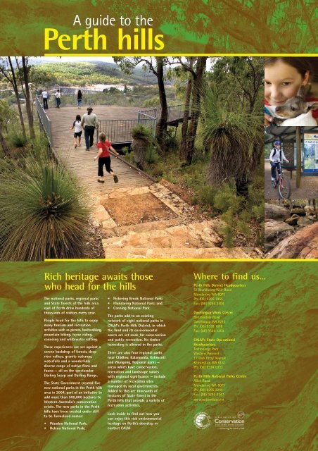
A guide to thePerth <strong>hills</strong>Rich heritage awaits thosewho head for the <strong>hills</strong>The national parks, regional parks<strong>and</strong> State <strong>forest</strong>s <strong>of</strong> the <strong>hills</strong> areaeast <strong>of</strong> Perth draw hundreds <strong>of</strong>thous<strong>and</strong>s <strong>of</strong> visitors every year.People head for the <strong>hills</strong> to enjoymany tourism <strong>and</strong> recreationactivities such as picnics, bushwalking,mountain biking, horse riding,canoeing <strong>and</strong> whitewater rafting.These experiences are set against aserene backdrop <strong>of</strong> <strong>forest</strong>s, deepriver valleys, granite outcrops,waterfalls <strong>and</strong> a wonderfullydiverse range <strong>of</strong> native flora <strong>and</strong>fauna — all on the spectacularDarling Scarp <strong>and</strong> Darling Range.The State Government created fivenew national parks in the Perth <strong>hills</strong>area in 2004, part <strong>of</strong> an initiative toadd more than 500,000 hectares toWestern Australia's conservationestate. The new parks in the Perth<strong>hills</strong> have been created under stillto be formalised names:• W<strong>and</strong>oo National Park;• Helena National Park;• Pickering Brook National Park;• Mundaring National Park; <strong>and</strong>• Canning National Park.The parks add to an existingnetwork <strong>of</strong> eight national parks inCALM’s Perth Hills District, in whichthe l<strong>and</strong> <strong>and</strong> its environmentalassets are set aside for conservation<strong>and</strong> public recreation. No timberharvesting is allowed in the parks.There are also four regional parksnear Chidlow, Kalamunda, Kelmscott<strong>and</strong> Wungong. Regional parks —areas which have conservation,recreation <strong>and</strong> l<strong>and</strong>scape valueswith regional significance — includea number <strong>of</strong> recreation sitesmanaged by local governments.Added to this are thous<strong>and</strong>s <strong>of</strong>hectares <strong>of</strong> State <strong>forest</strong> in thePerth <strong>hills</strong> that provide a variety <strong>of</strong>recreation activities.Look inside to find out how youcan enjoy this rich environmentalheritage on Perth’s doorstep orcontact CALM.Where to find us…Perth Hills District Headquarters51 Mundaring Weir RoadMundaring WA 6073Ph: (08) 9295 1955Fax: (08) 9295 2404Dwellingup Work CentreBanksiadale RoadDwellingup WA 6213Ph: (08) 9538 1078Fax: (08) 9538 1203CALM’s State OperationalHeadquartersTechnology ParkWestern Precinct17 Dick Perry AvenueKensington WA 6151Ph: (08) 9334 0333Perth Hills National Parks CentreAllen RoadMundaring WA 6073Ph: (08) 9295 2244Fax: (08) 9295 3247www.naturebase.net
Healthy parks, healthy peopleGoing bush for good healthWhen was the last time you escapedthe hustle <strong>and</strong> bustle <strong>of</strong> modern citylife for a relaxing visit to one <strong>of</strong> themagnificent national parks on Perth'sdoorstep?If you do it <strong>of</strong>ten, the chances are yourhealth will benefit. There's a growingbody <strong>of</strong> evidence worldwide thatestablishes a strong positive linkbetween people visiting parks <strong>and</strong> theirphysical <strong>and</strong> mental health. In turn,healthy individuals contribute to ahealthy community.There's something for everyone in thePerth <strong>hills</strong>. Relax under a shady tree inone <strong>of</strong> the many well-equippedrecreation sites, tackle the network <strong>of</strong>tracks <strong>and</strong> trails spanning the nationalparks <strong>and</strong> <strong>forest</strong>s, or take a closer lookat nature through a broad range <strong>of</strong>educational activities <strong>of</strong>fered by CALM.Those with a special interest can evenvolunteer to help look after our naturalbush <strong>and</strong> all that lives there. Howhealthy is that?Of course, national parks also have apositive impact on all <strong>of</strong> us byimproving air quality, reducing erosion,delivering clean drinking water <strong>and</strong>contributing to clean waterways.So, wherever you look, national parksare about good health. Make your nextbreak a healthy one <strong>and</strong> head for thebush!Perth Hills National Parks CentrePerth’s <strong>hills</strong> area has 10 national parks that are anatural playground <strong>of</strong> waterfalls, shady picnic areas,panoramic lookouts, campgrounds, cycle trails <strong>and</strong>scenic walks <strong>of</strong> every length <strong>and</strong> difficulty.With so many locations <strong>and</strong> things to do, how can youget information on the best places to visit with yourfamily <strong>and</strong> friends?The new Perth Hills National Parks Centre is the answer.Open seven days a week from May 2006, the centre isonly 40 minutes from Perth <strong>and</strong> has information onall <strong>of</strong> the national parks in the Perth Hills area.Located at the ‘hub’ <strong>of</strong> the Perth Hills near MundaringWeir, there are plenty <strong>of</strong> other things to do at theNational Parks Centre. Terrific interpretive displaysinside the visitors’ building will give you an insightinto the beauty <strong>and</strong> biodiversity <strong>of</strong> a jarrah <strong>forest</strong>.You can experience the <strong>forest</strong> by walking one <strong>of</strong> theseveral walk trails available. The world famousBibbulmun Track passes right through the middle <strong>of</strong>the Perth Hills National Parks Centre <strong>and</strong> cyclists canalso get easy access to the Munda Biddi Trail.If you need a map, forgot your hat or water bottle orneed to buy someone a unique present, the shop has avariety <strong>of</strong> products. You can buy a c<strong>of</strong>fee or cold drinkto enjoy while you peruse the displays or relax in thenatural surrounds.Don’t rush <strong>of</strong>f after having a quick look around, asthere are other interesting attractions. Experiencebeautiful evenings in the <strong>forest</strong> by staying at one <strong>of</strong>the centre’s two campgrounds or the Djaril-Mari YHA,catch a movie at the Kookaburra Outdoor Cinemafrom November to April or have something to eat <strong>and</strong>drink at the historic Mundaring Weir Hotel orLavender Path tearooms.The Perth Hills National Parks Centre is located onAllen Rd (<strong>of</strong>f Mundaring Weir Rd), 7 km south <strong>of</strong>Mundaring. Follow the signs from Mundaring orKalamunda.Further information is available fromwww.naturebase.net, or call CALM’s helpful staff on9295 2244.Above <strong>and</strong> right The new Perth HillsNational Parks Centre makes itstransition from being a staff home toa refurbished facility at Mundaring.Writer: Don ScottManaging Editors: Caris Bailey, Sue McKenna <strong>and</strong>Rhianna KingDesign <strong>and</strong> production: Gooitzen van der MeerPublished by the <strong>Department</strong> <strong>of</strong> Conservation<strong>and</strong> L<strong>and</strong> Management February 2006www.naturebase.net2
Rich flora display makes <strong>hills</strong> a biodiversity hotspotThe bush <strong>of</strong> the Darling Range comes alive in asea <strong>of</strong> colour as a multitude <strong>of</strong> native shrubs<strong>and</strong> trees burst into flower from late winter toearly spring.This is a great time to use the network <strong>of</strong> bushtracks <strong>and</strong> trails to get up close to the floweringplants.In all, there are believed to be between 1700<strong>and</strong> 2000 native species growing in the <strong>hills</strong>.Between 40 <strong>and</strong> 50 <strong>of</strong> these are endemic to thearea (they don’t grow anywhere else).You might see Darling Range ghost gumsgrowing five to 10 m tall from the cracks <strong>of</strong> thegranite outcrops, the beautiful granite pixie mopshrub (Petrophile biloba) with heads <strong>of</strong> pinkflowers in late spring or the c<strong>and</strong>le cranberryshrub (Astroloma foliosum) with bursts <strong>of</strong> red,black <strong>and</strong> green flowers in late winter.Those wanting tall timber can head to LanePoole Reserve where the wetter climate seestaller jarrah <strong>and</strong> blackbutt trees proliferate. Thenthere are the gnarled w<strong>and</strong>oo trees that providea haven for birds in W<strong>and</strong>oo National Park <strong>and</strong>in other areas east <strong>of</strong> the Darling Scarp.The people <strong>of</strong> Perth are fortunate to have suchrich biodiversity on their doorstep.The entire area west <strong>of</strong> an imaginary linebetween Geraldton <strong>and</strong> Esperance has beenrecognised internationally as one <strong>of</strong> 34biodiversity hotspots in the world.More recently, the Perth <strong>hills</strong> area, encompassingthe Darling Scarp <strong>and</strong> adjoining Darling Rangesurrounding jarrah <strong>forest</strong>s, has been recognisednationally as a hotspot within a hotspot. Thisreflects the enormous plant diversity found here,arising from a unique combination <strong>of</strong> soils <strong>and</strong>climates.The escarpment is an overlap area betweenthe s<strong>and</strong>y coastal plain <strong>and</strong> thelaterites that support the jarrah<strong>forest</strong>s. It is common to find 50 or60 plant species in a 100 squaremetre area, then many differentplants in a block nearby.Rainfall is higher near the scarp,increasing as you go south in thePerth <strong>hills</strong>, but drops awayrapidly as you head north<strong>and</strong> east. So, the <strong>hills</strong>represent the southern,northern or eastern reaches<strong>of</strong> many species.Surprisingly, many Wheatbelt speciessuch as ferns encroach onto the scarp, beingable to endure arid summers on the numerousgranite outcrops.Tuning in to the <strong>forest</strong>‘Listening’ to the l<strong>and</strong> as you movethrough the <strong>hills</strong> area can help you gainappreciation for Aboriginal culture.Aboriginal people believe the l<strong>and</strong> canguide those who ‘listen’ to the l<strong>and</strong> <strong>and</strong>connect with it by taking the time tostop, relax <strong>and</strong> soak in the environment.To the Nyoongar people, the Perth <strong>hills</strong>area is <strong>of</strong> deep cultural significance <strong>and</strong>contains many sites that must not bedisturbed.The granite outcrops you will see dottedthroughout the <strong>hills</strong> <strong>and</strong> valleys are <strong>of</strong>particular significance, with some listedas Aboriginal Heritage Sites. Many <strong>of</strong>these have deep spiritual significance tothe Nyoongar people. Not all <strong>of</strong> themare heritage sites, but they are allconnected in Aboriginal culture.There are also many places in thenational parks where Nyoongar peopletraditionally made tools. The removal <strong>of</strong>artifacts such as spearheads <strong>and</strong>grinding stones from such places, or anyother form <strong>of</strong> damage to designatedAboriginal Heritage Sites, can exposeyou to heavy penalties.There are many opportunities for you tolearn more about Aboriginal culture.The Hills Forest Discovery Centre inMundaring houses CALM’s Nearer toNature <strong>and</strong> EcoEducation programs.Phone 9295 2244 or emailn2n@calm.wa.gov.au for details.CALM's Indigenous Heritage Unit alsoruns Sharing the Dreaming indoor <strong>and</strong>outdoor courses for groups. Bookingscan be made on 9334 0564 or by email(deniseg@calm.wa.gov.au).Indigenous cultural programs fortourists <strong>and</strong> students are also run inother parts <strong>of</strong> the State, including atYanchep National Park.Western Shieldoutfoxes predatorsWoylies, quendas, chuditch, quokkas, western brushwallabies <strong>and</strong> brush-tailed phascogales…these are all unique WA marsupialsthat are being given a better thanfighting chance in the Perth <strong>hills</strong>area through CALM's world-classWestern Shield program.Pioneered in 1994, Western Shieldis an aggressive native faunarecovery strategy involving aerial <strong>and</strong>ground baiting to control introducedpredators such as European red foxes <strong>and</strong> feral cats.It also involves breeding endangered species in captivity<strong>and</strong> translocating animals to areas where their numbershave dwindled.The baits are laced with 1080 poison, a substance that occursnaturally in the native poison pea plant <strong>and</strong> to which ournative animals are highly tolerant, unlike the predators.Western Shield is a direct response to the enormous decline innative mammals across Australia since European arrival.Foxes <strong>and</strong> cats have already contributed to the extinction <strong>of</strong>10 native mammal species <strong>and</strong> many others are threatened.Brush tailed phascogaleThe program extends across 3.7 million ha<strong>of</strong> conservation l<strong>and</strong> from WA'sSouth Coast to the BurrupPeninsula in the north, <strong>and</strong> hasdelivered significant successwith the woylie, quenda <strong>and</strong>the tammar wallaby, which havebeen removed from the endangeredspecies list in recent years.Tammar wallabyWestern Shield is most effectivein protecting animals in the 35gm to 8 kg weight range — thosehunted by foxes. However, the battle isongoing <strong>and</strong> always difficult.3
Avon Valley areaAvon Valley National ParkAvon Valley National Park is a 4500-ha reserve<strong>and</strong> features <strong>forest</strong>s <strong>and</strong> granite outcrops,panoramic views over the Avon Valley, <strong>and</strong> thechance to see a wide variety <strong>of</strong> wildflowers,birds <strong>and</strong> wildlife. The Avon River flows inwinter <strong>and</strong> spring over spectacular rapids.Where is it? 80 km north-east <strong>of</strong> Perth viaToodyay Road. Turn left onto Morangup Road<strong>and</strong> left onto Quarry Road. A self-registrationentry station is located near this point.Travelling time: 1 hr from Perth.Fees: Entry <strong>and</strong> camping fees apply.What to do: Bushwalking, picnicking,canoeing, wildlife observation, <strong>and</strong> bushcamping (by arrangement with the parkranger).Facilities: Wood barbecues (bring your ownwood), shaded picnic areas, toilets.Best seasons: Autumn, winter, spring.Major sites within the park: Bald Hill, ValleyCampsite, Homestead Campsite, Cec BarrowsCampsite (group camping only).Walyunga National ParkWalyunga National Park is almost 1800 ha insize <strong>and</strong> it is here that the Avon River becomesthe Swan River, running through the centre <strong>of</strong>the park. The valley sides show outcrops <strong>of</strong>granite with the occasional darker doleriteshowing. The vegetation within the park variesfrom flooded gums on the valley floor to areas<strong>of</strong> w<strong>and</strong>oo, marri, powderbark <strong>and</strong> jarrah. Thepark was once the location <strong>of</strong> one <strong>of</strong> the largestAboriginal camps near Perth <strong>and</strong> was still usedby the Nyoongar people in the late 1800s.Where is it? 40 km north-east <strong>of</strong> Perth alongthe Great Northern Highway.Travelling time: 1 hr from Perth.Fees: Entry <strong>and</strong> camping fees apply.What to do: Bushwalking, picnicking, canoeing,wildlife observation <strong>and</strong> bush camping (byarrangement with the park ranger).Facilities: Gas barbecues, shaded picnic areas,toilets, walktrails.Best seasons: Autumn, winter <strong>and</strong> spring.Major sites within the park: Boongarrup Pool,Walyunga Pool.Walktrails within the park: Echidna Trail –10.6 km, Kangaroo Trail – 4 km,Kingfisher Trail – 8.5 km, Syd’s Rapids – 5.2 km.Mundaring/Kalamunda areaCanning National ParkLocated between Brookton Highway <strong>and</strong> theCanning Reservoir this 2500-ha park is mainlyjarrah <strong>forest</strong> <strong>and</strong> forms an important watercatchment area for the reservoir. CanningNational Park has high conservation values asmany flora <strong>and</strong> fauna species are located withinits boundaries <strong>and</strong> adjacent areas. Included inthe park is the Boulder Rock picnic area.LesleyWhere is it? 47 km from Perth along BrooktonHighway.Travelling time: 1 hr.Fees: Not applicable.What to do: Picnicking, bushwalking, wildlifeobservation.Facilities: Wood barbecues (bring your ownwood), toilet, picnic area.Best season: Late autumn, winter <strong>and</strong> spring.Gooseberry Hill National ParkThis hilly, 33-ha reserve has magnificent views<strong>of</strong> the Swan Coastal Plain. A one-way scenicdrive, known as the Zig-Zag, leads downhillthrough the park <strong>and</strong> provides amazingphotography <strong>and</strong> birdwatching opportunities.Zig-ZagWhere is it? 16 km from Perth. Take GooseberryHill Road, turn left into Williams Street/LascellesParade.Travelling time: 30 min from Perth.Fees: Not applicable.What to do: Photography, birdwatching, scenicdrive or walk down the Zig-Zag.Facilities: None.Best seasons: Autumn, winter <strong>and</strong> spring.Statham’s QuarryWhere is it? 18 km from Perth. Turn onto ScottStreet (<strong>of</strong>f Great Eastern Highway) <strong>and</strong> then leftinto Helena Valley Road <strong>and</strong> right into RidgehillRoad.Travelling time: 30 min from Perth.Fees: Not applicable.What to do: Photography, birdwatching,abseiling/rock climbing (authorised groups only).Facilities: Toilets.Best seasons: Autumn, winter <strong>and</strong> spring.Greenmount National ParkA 56-ha park <strong>of</strong> marri, jarrah <strong>and</strong> w<strong>and</strong>oo <strong>forest</strong>on the slope <strong>of</strong> Greenmount Hill, overlookingPerth <strong>and</strong> the Swan Coastal Plain.Mountain QuarryWhere is it? 16 km from Perth. Turn onto ScottStreet (<strong>of</strong>f Great Eastern Highway) <strong>and</strong> then leftonto Coulston Road.Travelling time: 30 min from Perth.Fees: Not applicable.What to do: Photography, birdwatching,abseiling/rock climbing (authorised groups only).Facilities: Toilets.Best seasons: Autumn, winter <strong>and</strong> spring.Greenmount LookoutWhere is it? Padbury Road. Turn ontoDarlington Road (<strong>of</strong>f Great Eastern Highway)<strong>and</strong> then onto Oxley Road <strong>and</strong> Padbury Road.Travelling time: 30 min from Perth.Fees: Not applicable.What to do: Photography, birdwatching.Facilities: None.Best seasons: Autumn, winter <strong>and</strong> spring.Helena National ParkLocated to the east <strong>of</strong> Lake C Y O’Connor, this8000-ha park includes the popular recreationsite <strong>of</strong> Mount Dale, which provides 360-degreeviews over State <strong>forest</strong> <strong>and</strong> national park areas.The Bibbulmun Track travels through the park asit heads south towards Albany.Mount DaleWhere is it? Follow Brookton Highway fromKelmscott for 47 km. Turn left into AshendonRoad <strong>and</strong> then turn right into Dale Road (6 km).Follow Dale Road to Mount Dale.Travelling time: 1 hr 20 min.Fees: Not applicable.What to do: Picnicking, bushwalking, wildlifeobservation.Facilities: Wood barbecues (bring your ownwood), toilet, picnic area, wildlife viewing hide.Best season: Late autumn, winter <strong>and</strong> spring.John Forrest National ParkOriginally declared as a conservation reserve in1898, John Forrest is WA’s oldest national park.The visitor area contains a tavern <strong>and</strong> tearooms,cultivated gardens <strong>of</strong> native plants <strong>and</strong> a barbecuearea. The rest <strong>of</strong> the park is largely undeveloped<strong>and</strong> is home to a variety <strong>of</strong> plant communities<strong>and</strong> wildlife. Several walktrails run throughvarious parts <strong>of</strong> the park including the RailwayReserve Heritage Trail, which follows thealignment <strong>of</strong> the old railway line to York. Visitorscan walk through the only railway tunnel in WA— the Swan View Tunnel. The Eagle View WalkTrail is a 15-km bushwalking circuit that leads tosome <strong>of</strong> the park’s less explored areas.Mahogany Creek <strong>and</strong> Jane Brook run throughthe valley in John Forrest, providing spectacularwaterfalls during winter <strong>and</strong> early spring. Thetwo main waterfalls are Hovea Falls <strong>and</strong>National Park Falls.Where is it? 26 km east <strong>of</strong> Perth via the GreatEastern Highway through Midl<strong>and</strong>.Travelling time: 30 min from Perth.Fees: Entry fees apply.What to do: Bushwalking, picnicking, wildlifeobservation, photography, mountain bike riding(Railway Reserve Heritage Trail).Facilities: Electric barbecues, toilets, water, kiosk.Best seasons: Autumn, winter <strong>and</strong> spring.4
Kalamunda National ParkKalamunda National Park is 375-ha <strong>and</strong> isnotable for its diversity <strong>of</strong> plants <strong>and</strong> animals.Piesse Brook runs through the park <strong>and</strong> the slopes<strong>of</strong> the valley are covered with open woodl<strong>and</strong> <strong>of</strong>jarrah, marri, w<strong>and</strong>oo <strong>and</strong> buttergum.Where is it? 25 km east <strong>of</strong> Perth. FromKalamunda take Mundaring Weir Road, then turnonto Hummerston Road <strong>and</strong> Schipp Road.Travelling time: 40 min from Perth.Fees: Not applicable.What to do: Bushwalking, wildlife observation,photography.Facilities: None.Best seasons: Autumn, winter <strong>and</strong> spring.Lesmurdie Falls National ParkThe Lesmurdie Brook flows through the centre <strong>of</strong>the park <strong>and</strong> tumbles over the sheer face <strong>of</strong> theDarling Scarp to fall 50 m to the coastal plain. Inwinter the waterfalls pour over the stream’sgranite bedrock.Where is it? 22 km east <strong>of</strong> Perth via WelshpoolRoad. Turn left into Falls Road from LesmurdieRoad.Travelling time: 30 min from Perth.Fees: Not applicable.What to do: Bushwalking, wildlife observation,photography, picnicking.Facilities: Barbecues, toilets, water.Best seasons: All year.Pickering Brook National ParkLocated around the townsites <strong>of</strong> Karragullen <strong>and</strong>Pickering Brook, this 6000-ha park is popular forbushwalking. The Munda Biddi Trail <strong>and</strong> theKattamorda Heritage Trail travel through parts<strong>of</strong> this park.Where is it? Canning Road <strong>and</strong> Pickering BrookRoad, Pickering Brook.Travelling time: 45 min from Perth.Fees: Not applicable.What to do: Bushwalking, mountain bikeriding.Facilities: None.Best seasons: Autumn, winter <strong>and</strong> spring.Mundaring National ParkSituated to the west <strong>of</strong> Mundaring Weir Road inthe Shires <strong>of</strong> Kalamunda <strong>and</strong> Mundaring, this3000-ha park includes the popular recreationsites <strong>of</strong> Fred Jacoby Park, North Ledge, FarrellGrove <strong>and</strong> South Ledge. Golden View lookout,located at South Ledge, provides panoramicviews over Lake C Y O’Connor, the Helena RiverValley <strong>and</strong> the Mundaring Weir.Fred Jacoby ParkThis l<strong>and</strong>scaped park is planted with trees frommany parts <strong>of</strong> the world, including one <strong>of</strong> thelargest English oak trees in WA. The park ispopular for family gatherings <strong>and</strong> weddings.Where is it? 37 km from Perth on MundaringWeir Road.Travelling time: 45 min from Perth.Fees: Not applicable.What to do: Bushwalking, picnicking, wildlifeobservation, photography.Facilities: Wood barbecues (bring your ownwood), shaded picnic areas, toilets.Best seasons: All year.South LedgeThe South Ledge picnic area is surrounded byjarrah <strong>forest</strong> <strong>and</strong> a short walktrail leads to theGolden View lookout which provides spectacularviews over the Helena Valley, Lake C Y O’Connor<strong>and</strong> Mundaring Weir.Where is it? 40 km from Perth on MundaringWeir Road.Travelling time: 1 hr from Perth.Fees: Not applicable.What to do: Bushwalking, picnicking, wildlifeobservation, photography.Facilities: Wood barbecues (bring your ownwood), shaded picnic areas, toilets, on-siteinterpretation.Best seasons: All year.Mundaring Weir Road picnic sitesAlong Mundaring Weir Road between Mundaring<strong>and</strong> Kalamunda are several small picnic sites setamong the jarrah <strong>forest</strong>. These sites includePimelia Mycumbene, Grevillea Mycumbene, NorthLedge, Farrell Grove, Gungin Gully <strong>and</strong> The Dell.Travelling time: 1 hr from Perth.Fees: Not applicable.What to do: Bushwalking, picnicking, wildlifeobservation, photography.Facilities: Wood barbecues (bring your ownwood), shaded picnic areas, toilets.Best seasons: Autumn, winter <strong>and</strong> spring.The Hills Forest Discovery CentreLocated in Mundaring National Park is The HillsForest Discovery Centre — home to CALM’spopular Nearer to Nature <strong>and</strong> EcoEducationprograms. Nearer to Nature providesopportunities for locals <strong>and</strong> visitors to take partin unique, engaging guided activities at a range<strong>of</strong> natural environments in <strong>and</strong> around Perth,including The Hills Forest Discovery Centre.Where is it? Allen Road, Mundaring. TakeMundaring Weir Road from Mundaring <strong>and</strong>Allen Road is on the left at the roundaboutabout 6 km from Mundaring.Travelling time: 45 min from Perth.Fees: Apply to guided activities <strong>and</strong> camping.What to do: Guided activities, camping,bushwalking, picnicking, wildlife observation,photography.Facilities: Toilets.Best seasons: All year.Weir View WalkThis 2 km walktrail starts at The Hills ForestDiscovery Centre <strong>and</strong> takes you through amixture <strong>of</strong> jarrah <strong>and</strong> marri <strong>forest</strong>s, with someareas <strong>of</strong> w<strong>and</strong>oo woodl<strong>and</strong>. The trail leads to asmall viewing platform overlooking Lake C YO’Connor <strong>and</strong> the Mundaring Weir. The walktakes around one hour to complete.The Hills Forest Discovery Centre CampgroundLocated adjacent to the discovery centre, thiscampground has been designed to cater for allgroups <strong>of</strong> people. The sites are set among jarrah<strong>and</strong> marri trees <strong>and</strong> provide a sense <strong>of</strong> being inthe <strong>forest</strong>. The campground kitchen has electricbarbecues, power, water <strong>and</strong> fridge. Bookingsare required for the campground <strong>and</strong> can bemade through the <strong>of</strong>fice at The Hills ForestDiscovery Centre.Patens Brook CampsitePatens Brook Campsite is a walk-in onlycampsite because it is located within a DiseaseRisk Area. A 5 km walk through jarrah <strong>and</strong> marri<strong>forest</strong> leads you to the campsite, which is setalongside a small winter flowing creek. Thiscampsite is for use by groups only <strong>and</strong> bookingsare required. Bookings can be made through the<strong>of</strong>fice at The Hills Forest Discovery Centre.W<strong>and</strong>oo National ParkSituated between Great Southern Highway <strong>and</strong>Brookton Highway this 44,000-ha national parkfeatures areas <strong>of</strong> w<strong>and</strong>oo <strong>forest</strong> <strong>and</strong> graniteoutcrops. The Mount Observation RecreationSite is situated <strong>of</strong>f Great Southern Highwayabout 80 km from Perth via The Lakes.Mount ObservationWhere is it? 80 km from Perth along the GreatEastern Highway to The Lakes, then along GreatSouthern Highway. Turn right at the signs onCatchment Road <strong>and</strong> follow the gravel road forabout 1.5 km.Traveling time: 90 min from Perth.Fees: Not applicable.What to do: Bushwalking, picnicking, wildlifeobservation, photography.Facilities: Wood barbecues (bring your ownwood), shaded picnic areas, wildlife viewinghide, toilets.Best seasons: Late autumn, winter <strong>and</strong> spring.Serpentine/Jarrahdale areaSerpentine National ParkSerpentine National Park is on the DarlingScarp, the western edge <strong>of</strong> a huge, titledancient plateau. Past weathering has resulted indistinct l<strong>and</strong>scapes <strong>of</strong> lateritic upl<strong>and</strong>s, minor<strong>and</strong> major valleys, <strong>and</strong> abrupt scarps. TheSerpentine River contributes to the l<strong>and</strong>scapewith the steep slopes <strong>of</strong> the river valley <strong>and</strong>granite outcrops giving rise to the uniquefeature <strong>of</strong> the park, the Serpentine Falls. Inwinter, the river rushes down a sheer graniteface, polished by past rushing water, cascading15 m into the rock pool below.Where is it? 26 km south <strong>of</strong> Armadale. TakeSouth West Highway from Armadale <strong>and</strong> turnleft onto Falls Road.Travelling time: 1 hr <strong>and</strong> 15 min from Perth.Fees: Entry fees apply.What to do: Picnicking, bushwalking, wildlifeobservation.Facilities: Gas barbecues, toilets.Best seasons: Spring for wildflowers, winterfor the waterfall.Walktrails in the park: Kitty’s Gorge Walktrail– 11 km return, takes 5 hr.Kitty’s Gorge WalktrailNamed after a cow called Kitty, which w<strong>and</strong>eredaway from home <strong>and</strong> was found months laterbeside the gorge, the trail begins at the falls’ carpark. A short, steep climb leads to an easy walkalong the Serpentine River <strong>and</strong> Gooralong Brookinto Kitty’s Gorge. A series <strong>of</strong> markers (pineposts with orange triangles) should be followed.Early into the walk, Spencer’s Mud Cottage, aheritage building, originally built by thepioneering Spencer family, can be seen. Once inKitty’s Gorge, there is a series <strong>of</strong> waterfallsleading to the gauging station <strong>and</strong> weir.Highlights <strong>of</strong> the walk are the granite outcropplant communities in the gorge, <strong>and</strong> the jarrah<strong>forest</strong>.5
Baldwins Bluff Nature Trail — 6 km return,takes 2 hr.The walk begins behind the toilet block in thefalls picnic area. A medium level <strong>of</strong> fitness isrequired, as a steep gravel track has to beovercome to reach the top <strong>of</strong> the bluff. Theascent <strong>of</strong> the hill sees the vegetation changefrom redgum <strong>forest</strong> to w<strong>and</strong>oo with a variety <strong>of</strong>bird life including twenty-eights, western king(red-capped) parrots <strong>and</strong> splendid fairy wrens.At the top <strong>of</strong> the hill, the path turns right pastgranite outcrops. At the summit, spectacularviews <strong>of</strong> the Serpentine Falls <strong>and</strong> a vast area <strong>of</strong>the park can be enjoyed.Christmas Tree WellThis is a shady picnic area, with large paperbarktrees <strong>and</strong> clumps <strong>of</strong> the Christmas tree (Nuytsiafloribunda), on the edge <strong>of</strong> w<strong>and</strong>oo country. TheChristmas tree is the largest member <strong>of</strong> theparasitic mistletoe family <strong>and</strong> obtains part <strong>of</strong> itsnourishment by latching onto the roots <strong>of</strong> otherplants. In December, the Christmas trees burstinto brilliant orange flowers.Where is it? 72 km from Perth. Take BrooktonHighway out <strong>of</strong> Kelmscott.Travelling time: 1 hr 15 min from Perth.Fees: Not applicable.What to do: Picnicking, bushwalking.Facilities: Wood barbecues (bring your own wood).Best seasons: Spring <strong>and</strong> early summer.GleneagleOriginally the Gleneagle settlement, this picnicarea has secluded <strong>and</strong> shaded spots <strong>of</strong>f thebitumen perimeter road. It is set in a woodedarea <strong>of</strong> pines, marri <strong>and</strong> jarrah. There is also asmall arboretum <strong>of</strong> non-local trees <strong>and</strong> shrubssuch as bluegums, sugar gums, rodanthus,acacias, tea-trees, figs <strong>and</strong> jacar<strong>and</strong>as. Many <strong>of</strong>these trees are from the gardens <strong>of</strong> the originalsettlement. The area is well populated by birds,including western king parrots.Where is it? 55 km south-east <strong>of</strong> Perth. TakeAlbany Highway out <strong>of</strong> Armadale.Travelling time: 1 hr 20 min from Perth.Fees: Not applicable.What to do: Picnicking, bushwalking.Facilities: Wood barbecues (bring your ownwood).Best seasons: All year.Langford ParkOnce the site <strong>of</strong> a bauxite-mining operation inthe early 1970s, Langford Park has beenextensively replanted <strong>and</strong> l<strong>and</strong>scaped for publicrecreation. An open grassed foreshore surroundsan artificial lake, <strong>and</strong> trees shade the picnic area.There are several trails in <strong>and</strong> around LangfordPark including bushwalking, mountain bikeriding<strong>and</strong> bridle trails.Where is it? 54 km from Perth. Travel 8.5 kmfrom Armadale on the South West Highway,turn left at Byford onto Nettleton Road, thenturn right at signs to Langford Park.Travelling time: 1 hr from Perth.Fees: Not applicable.What to do: Picnicking, bushwalking, horseriding, mountain bikeriding.Facilities: Wood barbecues (bring your ownwood), toilets.Best seasons: All year.Sullivan RockSullivan Rock, a granite outcrop withsurrounding laterite, was a regular stoppingplace for travellers by horse <strong>and</strong> cart. A well,originally established by convicts, can still beseen there. The numerous little rock pools foundon the rock itself contain many unusual waterplants, including extraordinary tiny ferns calledquillworts. The Bibbulmun Track passes throughthis area <strong>and</strong> Sullivan Rock is a popular drop<strong>of</strong>f/pick-upfor walkers on the track.Where is it? 65 km from Perth. Take AlbanyHighway out <strong>of</strong> Armadale.Travelling time: 90 min from Perth.Fees: Not applicable.What to do: Picnicking, bushwalking, wildlifeobservation.Facilities: Wood barbecues (bring your ownwood).Best seasons: Spring <strong>and</strong> early summer.Walktrails in the Jarrahdale areaThere are many walktrails in the Jarrahdale area,including the Blue Rock Walk Trail, the Wetl<strong>and</strong>Experience, the Mundlimup Timber Trail, <strong>and</strong> theBalmoral POW camp ruins <strong>and</strong> walk trail.For more information on these walks pick up abrochure at the Jarrahdale General Store.Dwellingup areaLane Poole ReserveSituated just 100 km from Perth nearDwellingup, the Lane Poole Reserve covers some55,000 ha <strong>of</strong> jarrah <strong>forest</strong>. The Murray Riverflows through the reserve, <strong>and</strong> <strong>of</strong>fers numerousrecreational activities from swimming <strong>and</strong>canoeing to white water rafting.The recreation sites <strong>of</strong> Baden Powell, Charlie’sFlat, Tony’s Bend, Yarragil, Chuditch, Nanga Mill,Stringers <strong>and</strong> Nanga Townsite are popular forcamping.Baden Powell (day-use <strong>and</strong> campground)Baden Powell <strong>of</strong>fers visitors the first view <strong>of</strong> theMurray River <strong>and</strong> consists <strong>of</strong> a day-use areawith an adjoining campground. It is very popularfor swimming <strong>and</strong> for picnics, as well as forcamping.Where is it? 9.5 km from Dwellingup alongNanga Road <strong>and</strong> 2 km from entry station onPark Road.Travelling time: 90 min from Perth.Fees: Camping fees apply. No fees for dayvisitors.What to do: Picnicking, swimming, canoeing,wildlife observation <strong>and</strong> camping in thecampground only (no camping in day-use area).Facilities: Wood barbecues (bring your ownfirewood), tables, toilets, bins, parking.Best seasons: All year.Chuditch campgroundChuditch campground was opened in September2004 <strong>and</strong> features numbered bays for individualgroup camping. It is named after WA’s largestmarsupial predator, the chuditch, which may beseen throughout the reserve (keep an eye out atnight as they are nocturnal). Otherwise referredto as the quoll, chuditch is the local Aboriginalname, which mimics the guttural call the animalmakes when disturbed.Where is it? 16 km from Dwellingup <strong>and</strong>8.5 km from entry on Park Road <strong>and</strong> over Bob’sCrossing. (During winter drive in via Nanga Millfrom Nanga Road).Travelling time: 2 hr from Perth.Fees: Camping fees apply.What to do: Camping, bushwalking, short walkor drive to river.Facilities: Individual camping bays, tables,toilets, enclosed camp kitchen with gasbarbecues (for campers <strong>and</strong> day visitors). Nowood fires are permitted at Chuditch. Pleasebring gas stove/cooker to use in camping bays.Best seasons: All year.Icy CreekSituated alongside the Lane Poole Reserve, IcyCreek <strong>Environment</strong>al Education Camp is a venuerequiring pre-booking for public access. It is verypopular with school groups <strong>and</strong> with peoplewho want to enjoy the peace <strong>and</strong> tranquility <strong>of</strong>a <strong>forest</strong> setting.Where is it? 14 km from Dwellingup alongNanga Road.Travelling time: 2 hr from Perth.Fees: Fees are applicableWhat to do: Camping, bushwalking, wildlifeobservation, photography.Facilities: Six cottages with eight beds eachwith mattress supplied. Hot showers, toilets,campground covered camp kitchen with fridge,gas burners <strong>and</strong> gas barbecue, tables, coveredrotunda with central fire place <strong>and</strong> grassed oval.Best seasons: All year.To book contact CALM’s Dwellingup <strong>of</strong>fice on9538 1078. A minimum <strong>of</strong> 20 people is requiredto book the venue exclusively.Nanga Mill <strong>and</strong> Nanga TownsiteThe popular recreation sites <strong>of</strong> Nanga Mill <strong>and</strong>Nanga Townsite have a strong link with thetimber milling days, when jarrah was harvestedin the area from as early as 1898. NangaTownsite came into existence in 1909, butduring the Dwellingup fire <strong>of</strong> 1961 thecountryside was devastated <strong>and</strong> the townsitewas incinerated <strong>and</strong> never rebuilt.6
Today at each site you can see the remains <strong>of</strong>this heritage from old railway formations toremnant garden plants such as poplars <strong>and</strong>blackberry.Where is it? Nanga Mill is 18.5 km fromDwellingup <strong>and</strong> 11 km from entry station onPark Road via Bob’s Crossing (accessed in wintervia Nanga Road, 5.5 km from entry station).Nanga Townsite is 13.5 km from Dwellingup <strong>and</strong>6 km from entry station via Nanga Road.Travelling time: 2 hr from Perth.Fees: Camping fees apply.What to do: Camping, bushwalking close toNanga Brook <strong>and</strong> Murray River.Facilities: Wood barbecues (bring your own firewood), tables, toilets, bins, walktrails.Best seasons: All year.Charlie’s FlatWhere is it? 14.5 km from Dwellingup <strong>and</strong>7 km from entry station, on River Road.Travelling time: 2 hr from Perth.Fees: Camping fees apply.What to do: Camping, swimming, canoeing.Facilities: Individual campsites, wood barbecues(bring your own firewood), tables, toilets, bins.Not suitable for large groups or caravans.Best seasons: All year.Bob’s CrossingWhere is it? 12.5 km from Dwellingup <strong>and</strong>5 km from entry station on River Road.Travelling time: 2 hr from Perth.Fees: Not applicable.What to do: Swimming, canoe pick-up/drop<strong>of</strong>f,10 min parking on crossing, no camping.Facilities: Concrete river crossing providingaccess to Chuditch, Nanga Mill <strong>and</strong> Stringers,except in winter when river floods (access viaNanga Road <strong>and</strong> Nanga Mill during flooding).Best seasons: All year.StringersWhere is it? 19 km from Dwellingup <strong>and</strong>11.5 km from entry on Park Road via Bob’sCrossing (via Nanga Road during winter intoNanga Mill).Travelling time: 2 hr from Perth.Fees: Camping fees apply.What to do: Camping, swimming, canoeing.Facilities: Campground, wood barbecues (bringown firewood), tables, toilets, rubbish bin, canoelaunch.Best seasons: All year.YarragilWhere is it? 20 km from Dwellingup <strong>and</strong> 12.5km from entry station on River Road.Travelling time: 2 hr from Perth.Fees: Camping fees apply.What to do: Camping, swimming, canoeing.Facilities: Small campsite, wood barbecues(bring own firewood), tables, toilet, rubbish bin.Not suitable for large groups or caravans.Best seasons: All year.Tony’s BendWhere is it? 17 km from Dwellingup <strong>and</strong>9.5 km from entry station on River Road.Travelling time: 2 hr from Perth.Fees: Camping fees apply.What to do: Camping, swimming, canoeing.Facilities: Individual campsites, wood barbecues(bring own firewood), tables, toilets, bin. Notsuitable for large groups or caravans.Best seasons: All year.Marrinup CampsiteThe Marrinup Campsite is situated where the oldMarrinup Townsite was established for timberharvesting (jarrah), in the 1880s. The Dwellingupfire <strong>of</strong> 1961 burnt what remained <strong>of</strong> thetownsite. It was closed due to resource decline<strong>and</strong> moved to Dwellingup.Where is it? 100 km from Perth <strong>of</strong>f Del ParkRoad near Dwellingup, or access via Grey Road,2 km from Dwellingup along the Pinjarra-Williams Road.Travelling time: 90 min from Perth.Fees: Not applicable.What to do: Camping, bushwalking, cycling(access to Marrinup Cycle Trail <strong>and</strong> Munda BiddiTrail).Facilities: Wood barbecues (bring ownfirewood), tables, toilet, camping area suitablefor caravans <strong>and</strong> group camping.Best seasons: All year.Marrinup POW CampIn the 1940s a Prisoner <strong>of</strong> War (POW) camp wasestablished at Marrinup to house some 200German <strong>and</strong> 1300 Italian POWs. The camp wasprimarily a staging post for Italian prisonersenroute to work on Wheatbelt properties. Thoseprisoners who lived permanently at the campwere employed as firewood cutters.Where is it? 100 km from Perth <strong>of</strong>f Del ParkRoad near Dwellingup, or access via Grey Road,2 km from Dwellingup along thePinjarra–Williams Road (follow the signs to POWcamp from Marrinup).Travelling time: 90 min from Perth.Fees: Not applicableWhat to do: Historical site. No campingpermitted at POW camp.Facilities: Toilet, some interpretive material,parking.Best seasons: All year.Marrinup FallsWhere is it? 100 km from Perth, access <strong>of</strong>f DelPark Road near Dwellingup or access via GreyRoad, 2 km from Dwellingup along thePinjarra–Williams Road (follow the signs toMarrinup Falls from Marrinup).Travelling time: 90 min from Perth.Fees: Not applicable.What to do: Bushwalking (Marrinup Fallswalktrail), wildlife observation, photography.No camping permitted at this site.Facilities: 1.5 km loop walktrail.Best seasons: Winter <strong>and</strong> spring for waterfalls<strong>and</strong> wildflowers.Other sitesThere are several State <strong>forest</strong> recreation siteswithin easy reach <strong>of</strong> Perth <strong>and</strong> close toDwellingup, including Oakley Falls, GoldmineHill, Scarp Pool <strong>and</strong> Scarp Lookout.Where are they? See back page map for details.Travelling time: 90 min to 2 hr from Perth.Fees: Not applicable.What to do: Picnicking, bushwalking, wildlifeobservation. Camping is not permitted at thesesites.Facilities: Toilets, tables, parking <strong>and</strong> shortwalks, <strong>and</strong> river access at Scarp Pool.Best seasons: Spring for wildflowers <strong>and</strong> winterfor waterfalls.Mountain biking in thePerth <strong>hills</strong>There are many mountain bike trails in the Perth<strong>hills</strong> area that provide a wide range <strong>of</strong>recreational opportunities for bike riders, rangingfrom leisurely rides to more challenging circuits<strong>and</strong> loops. Some <strong>of</strong> these trails are dual-use, soriders need to be aware <strong>of</strong> other trail riders atall times. Brochures <strong>and</strong> further information areavailable from CALM’s Mundaring <strong>of</strong>fice.Railway Reserve Trail — from Midl<strong>and</strong> to MtHelena <strong>and</strong> returnThe Railway Reserve Trail retraces 40 km <strong>of</strong> theold Eastern Railway constructed from Fremantleto York in the 1880s. It starts at the corner <strong>of</strong>Pechey <strong>and</strong> Morrison Roads in Swan View <strong>and</strong>goes through John Forrest National Park.Mundaring Loop Trail — from The Hills ForestDiscovery Centre to Mundaring <strong>and</strong> returnThe Mundaring Loop Trail is 15.5 km long <strong>and</strong>riders travel along old rail formations <strong>and</strong><strong>forest</strong>ry tracks as well as purpose built bike trailsthrough Mundaring National Park.Carinyah Trail — from Brookton Highway toCarinyah <strong>and</strong> returnThe Carinyah Trail is 15.7 km <strong>and</strong> takes ridersthrough the jarrah <strong>forest</strong> to old Carinyah<strong>forest</strong>ry settlement <strong>and</strong> part <strong>of</strong> the PickeringBrook National Park.7
Great places to climb <strong>and</strong> abseilIf you fancy rock climbing orabseiling, then the historicStatham's <strong>and</strong> Boya Mountaingranite quarries are the idealvenues.Statham's Quarry in GooseberryHill National Park in HelenaValley has two 25 km highrock faces open for suchactivities, while Boya Quarry(or Mountain Quary) inGreenmount National Park hasfaces <strong>of</strong> 15 m, 25 m <strong>and</strong> 50 m.To ensure maximum safety, allabseil leaders must haveNOLRS registration. It is alsoessential to book with CALM.Both quarries have climbinganchor points installed <strong>and</strong>there are toilets, a shelter <strong>and</strong>picnic tables nearby.Statham's Quarry is on thehistoric Zig-Zag railway thatran from Midl<strong>and</strong> toKalamunda. Both quarries havesignificant heritage value,having been among the firstcommercial quarries operatingin the Perth area.It is estimated that up to10,000 people climb or abseilat the two venues each year<strong>and</strong> the number is risingsteadily.For more information or tomake a booking, contactThe Hills Forest DiscoveryCentre on 9295 2244 or emailn2n@calm.wa.gov.au.Pets in parksDogs are welcome at mostregional parks around Perth, aswell as in State <strong>forest</strong>, timberreserves <strong>and</strong> some othercategories <strong>of</strong> reserve such asregional parks or at Lane PooleReserve near Dwellingup.Dogs are, however, not permittedin nature reserves, marine naturereserves or most national parks.NumbatIf you decide to take your doginto State <strong>forest</strong> or a CALMmanagedreserve where dogs arepermitted, make sure it is on alead <strong>and</strong> under effective control.1080 poison baits are laid insouth-west <strong>forest</strong> areas toeradicate foxes <strong>and</strong> cats as part <strong>of</strong>CALM’s wildlife recovery program,Western Shield (for more detailsabout this program see page 3).Native animals are tolerant tothe 1080 baits, which contain anatural poison, but they will killcats <strong>and</strong> dogs. There is noantidote.Check with the nearest CALMdistrict <strong>of</strong>fice to find out whichareas are currently baited. Youmay want to muzzle your dog toprevent it picking up a bait.Visually impaired people withguide dogs can take their dogsinto any CALM-managed area.National park passesWestern Australia boasts some five million ha <strong>of</strong>national parks featuring some <strong>of</strong> the mostspectacular l<strong>and</strong>scapes in the world.To access parks with entry fees, CALM <strong>of</strong>fersnational park passes.CALM spends the fees it collects at the parks onmaintaining <strong>and</strong> improving visitor facilities or onconservation projects.The national park passes are available from all CALM<strong>of</strong>fices (except Crawley), more than 40 WA touristcentres, park entry points or from rangers withinthose parks.At parks where entry points are not staffed, pleasetake one <strong>of</strong> the supplied envelopes, complete yourdetails, enclose the prescribed fee, tear-<strong>of</strong>f <strong>and</strong> retainthe receipt <strong>and</strong> deposit the envelope in the feecontainerprovided.Park passes do not cover camping. Other fees may apply.EchidnaCats should not be taken intoany area managed by CALM.Feral cats are a major threat towildlife, <strong>and</strong> have been linked tothe extinction <strong>of</strong> several smallnative mammal species.Day PassOnly four national parks in the Perth <strong>hills</strong> area —John Forrest, Avon Valley, Serpentine <strong>and</strong> Walyunga —are currently subject to day pass charges. A fee <strong>of</strong> $9per car (up to eight legally seated people), $3 permotorcycle <strong>and</strong> $3.40 per tour vehicle passengerprovides entry to one or more parks on the day.Annual Local Park PassThis pass, at $17 per vehicle (up to eight people),allows you to visit a park or group <strong>of</strong> parks in thesame area as many times as you wish for one year.Walyunga <strong>and</strong> Avon Valley National Parks are coveredon the one Annual Local Park Pass.Holiday PassThis pass entitles you to visit as many parks as youwish anywhere in WA during a four-week period. Thefee is $22.50 per vehicle (up to eight people).Annual All Parks PassIf you want to visit any park in WA for 12 months,this is the pass to have. The fee is $51 per vehicle (upto eight people).Gold Star PassThis is an annual all parks pass that includes a12-month subscription to LANDSCOPE. It’s availablethrough CALM <strong>of</strong>fices or when you subscribe to themagazine. The fee is $73 per vehicle (up to eightpeople) <strong>and</strong> includes four issues <strong>of</strong> CALM’s awardwinningmagazine.ConcessionsDrivers with a Seniors' Card, aged pension card or<strong>Department</strong> <strong>of</strong> Veterans' Affairs card pay a concessionprice <strong>of</strong> $3 per car for day passes or$1 per person when on private outings on buses(not including commercial tours).Groups <strong>of</strong> people with disabilities, or aged <strong>and</strong> infirmpeople entering parks on buses, as well as studentsundertaking educational activities in a park areentitled to free entry. Please apply in advance, inwriting, to CALM.CALM’s fees <strong>and</strong> charges are reviewed from time totime.8
Water activities rare, but dams <strong>of</strong>fer plenty for touristsThe network <strong>of</strong> rivers flowing through theDarling Range largely sustains Perth <strong>and</strong> itssurrounding areas.Dams in the valley gorges <strong>of</strong> the Helena, Canning<strong>and</strong> Serpentine rivers create reservoirs fromwhich the bulk <strong>of</strong> the region's drinking <strong>and</strong>irrigation water is taken.To prevent contamination <strong>of</strong> this resource,water-based activities such as swimming,boating, canoeing <strong>and</strong> fishing are not permittedin most areas surrounding the reservoirs.One <strong>of</strong> the few places where swimming ispermitted is near the picturesque SerpentineFalls in Serpentine National Park, downstreamfrom the drinking water supply reservoir.At this popular recreation spot, water cascades15 m down a sheer rock face <strong>and</strong> feeds two rockpools, one <strong>of</strong> which is open to swimmers. Pleaseobserve the warning signs. A nearby picnic areais also equipped with barbecues <strong>and</strong> picnicfacilities.The Mundaring Weir (now called Lake C YO’Connor) on the Helena River in MundaringNational Park has a special place in WA's history.In the late nineteenth century, WA's ChiefEngineer, C Y O'Connor, after whom the lake isnamed, built a 560-km pipeline, largely uphill, tosustain the Goldfields east <strong>of</strong> Perth during thegreat gold rush.The pipeline st<strong>and</strong>s as one <strong>of</strong> the greatengineering achievements <strong>of</strong> the era <strong>and</strong>continues to sustain the Goldfields today.Those interested in history can visit South Ledgelookout overlooking the weir <strong>and</strong> Helena Valley.There are also several tracks adjacent to thepipeline. The National Trust's Golden Pipelinetour (walk/drive) starts at the old No. 1 PumpStation Interpretive Centre below the dam wall<strong>and</strong> follows the pipeline, providing interpretiveinformation along the way.Dams at North D<strong>and</strong>alup <strong>and</strong> South D<strong>and</strong>aluphave picnic areas with gas barbecues <strong>and</strong> toilets,as well as walking trails. South D<strong>and</strong>alup is thelargest <strong>of</strong> the dams that supply drinking water toPerth, with a storage capacity <strong>of</strong> more than 200million cubic metres.So, while water-based activities are rare in thereservoir areas, there is plenty for visitors to see<strong>and</strong> do.For more details about tracks <strong>and</strong> trails aroundthe Serpentine, Mundaring <strong>and</strong> Canning dams,contact CALM's Tracks <strong>and</strong> Trails Unit on 9334 0265.For information about what activities allowed inthe area, visit the ‘Waterways’ section <strong>of</strong> the<strong>Department</strong> <strong>of</strong> <strong>Environment</strong>’s website(www.environment.wa.gov.au).Leave the car <strong>and</strong> hit the tracks for a closer viewIf you like to walk or ride a mountain bike youwill be spoilt for opportunities in the Perth<strong>hills</strong>.Apart from the popular Bibbulmun Track <strong>and</strong>the Munda Biddi Trail, there is a vast network<strong>of</strong> more than 50 tracks <strong>and</strong> trails spanning the<strong>hills</strong>, many <strong>of</strong> them <strong>of</strong>fering interpretivesignage providing information about theenvironment.The tracks allow you to leave your car behind<strong>and</strong> enjoy the best natural sites up close. Insome cases they will take you from the top <strong>of</strong>the scarp, to the very bottom <strong>and</strong> along thebanks <strong>of</strong> rivers.A favourite among walkers in the Jarrahdalearea is a track that runs from Gooralongthrough the Serpentine National Parkfollowing the river <strong>and</strong> finishing at SerpentineFalls.Another favourite is the Eagle View Walk Trailthat takes in part <strong>of</strong> John Forrest National Park<strong>and</strong> allows visitors to experience a variety <strong>of</strong>flora, fauna <strong>and</strong> l<strong>and</strong>scapes from high ground.Many mountain bikers favour the RailwayReserve Bike Trail that follows the route <strong>of</strong> adisused railway up the scarp <strong>and</strong> features a340 m tunnel built by WA's famous ChiefEngineer <strong>of</strong> the early twentieth century, C YO'Connor.Horse riders can enjoy the particularly scenicLower Helena Bridle Trail from Kalamunda toMundaring.For more details about walking <strong>and</strong> ridingopportunities in the <strong>hills</strong>, contact CALM’sPerth Hills District Headquarters atMundaring on 9295 1955 or CALM’sDwellingup <strong>of</strong>fice on 9538 1078. Detailedbrochures <strong>and</strong> maps are available for many <strong>of</strong>the trails.CALM has also produced two publications,Family Walks in Perth Outdoors <strong>and</strong> MoreFamily Walks in Perth Outdoors, which bothcontain maps <strong>and</strong> descriptions <strong>of</strong> around 50walks in <strong>and</strong> around the Perth area. Thesebooks retail for $16.95 <strong>and</strong> are availablefrom newsagents <strong>and</strong> bookstores as well asfrom CALM <strong>of</strong>fices <strong>and</strong> online at CALM'sNatureBase website at www.naturebase.net9
Fire is both friend <strong>and</strong> foeCALM, in cooperation with the Fire <strong>and</strong>Emergency Services Authority <strong>and</strong> localgovernment bushfire brigades, has acomprehensive fire risk management strategythat applies to the Perth <strong>hills</strong> area.This strategy involves prescribed burning toreduce bush fuel levels, an early spottingnetwork <strong>of</strong> towers <strong>and</strong> aircraft, grading <strong>of</strong> firebreaks <strong>and</strong> fire-fighting efforts from the air <strong>and</strong>on the ground.CALM's fire management strategy is not onlyabout preventing danger to people. Prescribedburning is an essential part <strong>of</strong> helping the bushregenerate.However, all visitors to the <strong>hills</strong> need to beaware they are entering a fire risk area,particularly in the warmer months, <strong>and</strong> need tobehave accordingly.• Please light campfires only where you areauthorised to do so. Such areas are clearlysign-posted <strong>and</strong> well cleared. In some cases,gas facilities are provided rather than openfires.• Always let a responsible person know you areheading into the bush. In the event <strong>of</strong> abushfire, it helps CALM to know who is in thearea.• Always stay on the tracks or trails provided.The frequency <strong>of</strong> burning is carefully managedaccording to the specific area to maximisebenefit to the types <strong>of</strong> plants <strong>and</strong> animals livingthere.Each year CALM plans to undertake prescribedburning on CALM-managed l<strong>and</strong>s in the southwestto:• protect <strong>and</strong> conserve biodiversity values <strong>and</strong>community assests;• reduce the occurrence <strong>and</strong> impacts <strong>of</strong> large,intense wildfires; <strong>and</strong>• regenerate <strong>and</strong> protect <strong>forest</strong> ecosystems.• If you spot smoke <strong>and</strong> feel a fire may beheading your way, get out as quickly aspossible. Again, stick to the tracks or trails.You will move much quicker on the tracksthan through the bush.• Please report any suspicious activity. CALM isalways on the lookout for arsonists.In January 2005 a bushfire burnt through28,000 ha <strong>of</strong> bush in the Perth <strong>hills</strong> area <strong>and</strong>required a massive inter-agency <strong>and</strong> communityresponse. This potentially devastating event wasa reminder <strong>of</strong> the importance <strong>of</strong> communityvigilance in preparing for fires <strong>and</strong> ensuring parkvisitor safety.A silent killer lurks in our bushAs you relax in the bush it's easy to overlook thelikelihood you are in the presence <strong>of</strong> a ruthlesskiller — jarrah dieback!This disease, otherwise known as Phytophthoracinnamomi, is a soil-based pathogen. It attacksthe roots <strong>of</strong> more than 3000 native species inthe south-west <strong>of</strong> WA, from tall trees to tinyshrubs <strong>and</strong> ground covers, destroying theirability to absorb water <strong>and</strong> transport nutrients.In smaller plants, death can be almost instantaneouson contact <strong>of</strong> the pathogen with the roots, butmost people recognise the disease in the ailingfoliage <strong>of</strong> jarrah trees, which take longer to die.WA's bush, including the Perth <strong>hills</strong>, is a hugemosaic <strong>of</strong> infected <strong>and</strong> uninfected areas. CALMscientists estimate the disease has seriouslydamaged up to 20 per cent <strong>of</strong> the naturalenvironment, greatly thinning the bush acrossthe State.Affected areas cannot be re-populated with thesusceptible native species without the ongoingapplication <strong>of</strong> protective treatments.The disease spreads naturally from one plant toanother through soil <strong>and</strong> water <strong>and</strong> little can bedone to halt its progress given the vastness <strong>of</strong>the areas affected. Humans can greatlyaccelerate its movement by spreading infectedsoil <strong>and</strong> plant tissue.Please obey signs advising you to wash or brushdown your feet, bike, car or four-wheel drive(mainly the tyres <strong>and</strong> undercarriage). The signsare usually positioned in Disease Risk Areas whereyou pass from an infected to an uninfected area<strong>and</strong> the risk <strong>of</strong> the disease spreading throughsoil that you may be carrying is very high. It isalso important that you obey any road closuresigns or gates as these are in place to help stopthe spread <strong>of</strong> the disease into uninfested areas.The disease has even spread into many bushreserves <strong>and</strong> back gardens <strong>of</strong> Perth throughinappropriate nursery practices (failure tosterilise soil used for seedlings), large-scalemovement <strong>of</strong> soil for housing subdivisions orroad construction, <strong>and</strong> by individuals.Whenever you go bush, stick to the firm pathsprovided, clean your feet <strong>and</strong>/or vehicle whererequested <strong>and</strong> conduct another clean-up beforereturning home. By no means remove any plantsor plant materials from their natural settings.More information about dieback is availablefrom CALM's NatureBase website(www.naturbase.net). Information can also beobtained by typing jarrah dieback into a websearch engine.You can also visit CALM's Perth Hills DistrictHeadquarters in Mundaring or phone9295 1955.10
A <strong>forest</strong> adventure on two wheelsA suitable bike, a trail map, some basicsupplies <strong>and</strong> a taste for <strong>forest</strong> adventure areall you need to tackle the extremely popularMunda Biddi Trail, starting at Mundaring inthe <strong>hills</strong> east <strong>of</strong> Perth.Munda Biddi, meaning ‘path through the<strong>forest</strong>’ in Nyoongar Aboriginal language, is thelatest addition to WA's growing network <strong>of</strong>world-class recreational trails. It provides agreat opportunity to combine a love <strong>of</strong> naturewith a desire for healthy activity.The car-free, <strong>of</strong>f-road trail, constructed <strong>and</strong>maintained by CALM with the assistance <strong>of</strong>the Munda Biddi Trail Foundation, windsthrough the eucalypt <strong>forest</strong>s, picturesque rivervalleys <strong>and</strong> rolling <strong>hills</strong> <strong>of</strong> the south-west onits way to Collie in the Darling Range, about300 km south. It will eventually extend about900 km to Albany on the South Coast.Along the northern section <strong>of</strong> the trail,observant cyclists might catch sight <strong>of</strong> anative western brush wallaby, brushtailpossum or western grey kangaroo which makethe jarrah <strong>forest</strong> their home. There is also awide variety <strong>of</strong> unique flora on display.A major access point to the Munda Biddi Trailis at its terminus in Sculpture Park,Mundaring. Other access points include TheDell recreation area on Mundaring Weir Road<strong>and</strong> where the track crosses Brookton Highway<strong>and</strong> Albany Highway <strong>and</strong> passes throughJarrahdale or Dwellingup. With these easyentry <strong>and</strong> exit points, you can cover as muchor as little <strong>of</strong> the trail as you choose.The trail is largely on gentle grades <strong>and</strong>designed for use by people <strong>of</strong> all ages <strong>and</strong>cycling experience levels. However, there aresome steep sections, particularly in the HelenaValley area <strong>and</strong> north <strong>of</strong> Jarrahdale <strong>and</strong> also nearDwellingup.Campsites are located at 35 to 50 km intervals<strong>and</strong> the trail passes through a town at leastevery second day. Some campsites are speciallydesigned for cyclists <strong>and</strong> feature a roomysleeping shelter, cycle storage, rainwater tanks<strong>and</strong> a toilet. You will need to take a fuel stove ifyou intend to cook.For more details about the Munda Biddi Trail,contact CALM's Tracks <strong>and</strong> Trails Unit on 93340265, email mundabiddi@calm.wa.gov.au, orvisit the Munda Biddi Trail Foundation’s websiteat (www.mundabiddi.org.au).Cycling <strong>and</strong> nature enthusiasts are encouragedto support the trail by joining the Munda BiddiTrail Foundation. Members receive regularnewsletters <strong>and</strong> discounts on merch<strong>and</strong>ise. Thefoundation also arranges special group events.Keep your four-wheel drive on track!Four-wheel driving through the wilds <strong>of</strong> the<strong>hills</strong> can be great fun, but it can also bedamaging to the environment.Stay on the tracksExcept in areas specially designated for <strong>of</strong>f-roaddriving (for vehicles such as trail bikes <strong>and</strong> dunebuggies), all vehicles must stay on establishedroads or tracks. The destructive practice <strong>of</strong>cross-country ‘bush bashing’ is not allowed.Why have controls?Destruction <strong>of</strong> flora <strong>and</strong> fauna, soil compaction<strong>and</strong> erosion, v<strong>and</strong>alism, littering <strong>and</strong> excessivenoise can all potentially occur as a result <strong>of</strong>four-wheel driving. Perhaps the greatestproblem <strong>of</strong> all, however, is the spread <strong>of</strong> thefungal disease dieback. This can be spread bysoil carried on the tyres <strong>and</strong> undercarriages <strong>of</strong>four-wheel drive vehicles. CALM hasdesignated <strong>and</strong> sign-posted various DiseaseRisk Areas, where vehicle traffic is strictlycontrolled through a permit system.Tread lightlyAll drivers have a duty <strong>of</strong> care to theenvironment when using public l<strong>and</strong>s. A 12-point Code <strong>of</strong> Ethics has been drawn up by theAustralian National Four Wheel Drive Councilin consultation with CALM. Behaviourst<strong>and</strong>ards are also prescribed by the TreadLightly program. Copies <strong>of</strong> the Code <strong>and</strong> theTread Lightly guidelines are available to thepublic.Other useful tips• Unlicensed vehicles are not allowed onCALM-managed l<strong>and</strong>s.• Build up your skills by doing a four-wheeldriving course through a four-wheel driveclub.• Buy a detailed map <strong>of</strong> the area you plan todrive through.• Allow extra time for unforeseencircumstances.• Plan alternative routes in case your originalroute is inaccessible.• Maintain appropriate tyre pressure toprotect the environment.• Thoroughly check your vehicle beforesetting <strong>of</strong>f.• Stay out <strong>of</strong> boggy areas.There are various planned four-wheel driveroutes through the <strong>hills</strong> <strong>and</strong> a number <strong>of</strong>publications containing useful informationabout them. For details, contact CALM's PerthHills District Headquarters in Mundaring on9295 1955 or visit CALM’s NatureBase website(www.naturebase.net).11
How to contact our parksPerth Hills National Parks CentrePh: (08) 9295 2244Fax: (08) 9295 3247Mundaring, Helena, W<strong>and</strong>oo,Pickering Brook <strong>and</strong> Canning national parksPh: (08) 9295 1955Fax: (08) 9295 2404Tracks, trails or organised activity enquiriesshould be directed to CALM’s Dwellingup WorkCentre on (08) 9538 1078.Other enquiries can be directed to CALM’sPerth Hills District Headquarters in Mundaringon (08) 9295 1955.www.naturebase.netWalyunga National ParkPh/Fax: (08) 9571 1371Serpentine National ParkPh/Fax: (08) 9525 2128Avon Valley National ParkPh/Fax: (08) 9571 3066John Forrest National ParkPh: (08) 9298 8344Fax: (08) 9298 9426Lane Poole ReservePh: (08) 9538 1078Fax: (08) 9538 1203


