Murchison 1 (MUR1 – East Murchison subregion) - Department of ...
Murchison 1 (MUR1 – East Murchison subregion) - Department of ...
Murchison 1 (MUR1 – East Murchison subregion) - Department of ...
You also want an ePaper? Increase the reach of your titles
YUMPU automatically turns print PDFs into web optimized ePapers that Google loves.
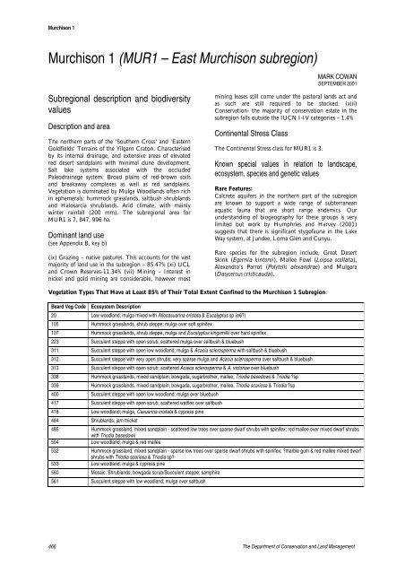
<strong>Murchison</strong> 1<strong>Murchison</strong> 1 (<strong>MUR1</strong> <strong>–</strong> <strong>East</strong> <strong>Murchison</strong> <strong>subregion</strong>)MARK COWANSEPTEMBER 2001Subregional description and biodiversityvaluesDescription and areaThe northern parts <strong>of</strong> the 'Southern Cross' and '<strong>East</strong>ernGoldfields' Terrains <strong>of</strong> the Yilgarn Craton. Characterisedby its internal drainage, and extensive areas <strong>of</strong> elevatedred desert sandplains with minimal dune development.Salt lake systems associated with the occludedPaleodrainage system. Broad plains <strong>of</strong> red-brown soilsand breakaway complexes as well as red sandplains.Vegetation is dominated by Mulga Woodlands <strong>of</strong>ten richin ephemerals; hummock grasslands, saltbush shrublandsand Halosarcia shrublands. Arid climate, with mainlywinter rainfall (200 mm). The <strong>subregion</strong>al area for<strong>MUR1</strong> is 7, 847, 996 ha.Dominant land use(see Appendix B, key b)(ix) Grazing <strong>–</strong> native pastures. This accounts for the vastmajority <strong>of</strong> land use in the <strong>subregion</strong> <strong>–</strong> 85.47% (xi) UCLand Crown Reserves-11.34% (vii) Mining <strong>–</strong> Interest innickel and gold mining are considerable, however mostmining leases still come under the pastoral lands act andas such are still required to be stocked. (xiii)Conservation- the majority <strong>of</strong> conservation estate in the<strong>subregion</strong> falls outside the IUCN I-IV categories <strong>–</strong> 1.4%Continental Stress ClassThe Continental Stress class for <strong>MUR1</strong> is 3.Known special values in relation to landscape,ecosystem, species and genetic valuesRare Features:Calcrete aquifers in the northern part <strong>of</strong> the <strong>subregion</strong>are known to support a wide range <strong>of</strong> subterraneanaquatic fauna that are short range endemics. Ourunderstanding <strong>of</strong> biogeography for these groups is verylimited but work by Humphries and Harvey (2001)suggests that there is significant styg<strong>of</strong>auna in the LakeWay system, at Jundee, Lorna Glen and Cunyu.Rare species for the <strong>subregion</strong> include, Great DesertSkink (Egernia kintorei), Mallee Fowl (Leipoa ocellata),Alexandra’s Parrot (Polytelis alexandrae) and Mulgara(Dasycercus cristicauda).Vegetation Types That Have at Least 85% <strong>of</strong> Their Total Extent Confined to the <strong>Murchison</strong> 1 Subregion:Beard Veg Code Ecosystem Description20 Low woodland; mulga mixed with Allocasuarina cristata & Eucalyptus sp (e6?)105 Hummock grasslands, shrub steppe; mulga over s<strong>of</strong>t spinifex107 Hummock grasslands, shrub steppe; mulga and Eucalyptus kingsmillii over hard spinifex223 Succulent steppe with open scrub; scattered mulga over saltbush & bluebush311 Succulent steppe with open low woodland; mulga & Acacia sclerosperma with saltbush & bluebush312 Succulent steppe with very open shrubs; very sparse mulga and Acacia sclerosperma over saltbush & bluebush313 Succulent steppe with open scrub; scattered Acaica sclerosperma & A. victoriae over bluebush338 Hummock grasslands, mixed sandplain; bowgada, sugarbrother, mallee, Triodia basedowii & Triodia ?sp339 Hummock grasslands, mixed sandplain; bowgada, sugarbrother, mallee, Triodia scariosa & Triodia ?sp400 Succulent steppe with open low woodland; mulga over bluebush417 Succulent steppe with open scrub; scattered wattles over saltbush418 Low woodland; mulga, Casuarina cristata & cypress pine484 Shrublands; jam thicket485 Hummock grassland, mixed sandplain - scattered low trees over sparse dwarf shrubs with spinifex; red mallee over mixed dwarf shrubswith Triodia basedowii504 Low woodland; mulga & red mallee532 Hummock grassland, mixed sandplain - sparse low trees over sparse dwarf shrubs with spinifex; ?marble gum & red mallee mixed dwarfshrubs with Triodia scariosa & Triodia sp?533 Low woodland; mulga & cypress pine560 Mosaic: Shrublands; bowgada scrub/Succulent steppe; samphire561 Succulent steppe with low woodland; mulga over saltbush466 The <strong>Department</strong> <strong>of</strong> Conservation and Land Management
<strong>Murchison</strong> 1Beard Veg Code Ecosystem Description862 Hummock grasslands, open low tree & mallee steppe; marble gum & mallee (E. kingsmillii) over hard spinifex Triodia basedowii863 Hummock grassland, mixed sandplain - sparse low trees over sparse dwarf shrubs with spinifex; red mallee over mixed dwarf shrubs withTriodia scariosa & Triodia sp?865 Hummock grassland, mixed sandplain - scattered low trees over sparse dwarf shrubs with spinifex; red mallee over mixed dwarf shrubswith Triodia scariosa & Triodia sp?1127 Mosaic: Saltbush & bluebush/samphire2121 Mosaic: Open low woodland; mulga/Succulent steppe; saltbush & bluebush on greenstone2902 Medium woodland; Allocasuarina cristata & goldfields blackbutt2903 Medium woodland; Salmon gum, goldfield blackbutt, gimlet & Allocasuarina cristataCentres <strong>of</strong> Endemism:The <strong>subregion</strong> is rich and diverse in both its flora andfauna however most species are wide ranging and usuallyoccur in at least one, and <strong>of</strong>ten several, adjoining<strong>subregion</strong>s.The only <strong>subregion</strong>al endemic species <strong>of</strong> vertebrateappears to be the Yellow-bellied Black Snake (Pseudechisbutleri). It is likely that a number <strong>of</strong> subterranean aquaticfauna are endemics but currently only the following areidentified:• Family Diosaccidae (marine family):Schizopera sp. nov.4 - known only from Lake Way and Lorna Glen;Schizopera sp. nov. 5 known only from Jundee andLorna Glen• Family Ameiridae (mostly a marine family): Nitocrellan. sp. 4 Lorna GlenRefugia:Lake Barlee - An intermittent salt lake that fillsapproximately every 10 years and persists for about 1year. Banded stilts (Cladorhynchus leucocephalus) breedthere and estimates <strong>of</strong> around 200,000 nests have beenreported. Burbidge and Fuller (1982) suggest that it maybe the most important breeding site for this species.Other water birds are also known to breed there.Existing <strong>subregion</strong>al or bioregional plans and/orsystematic reviews <strong>of</strong> biodiversity and threatsIn 1974 the Conservation Through Reserves Committee(CTRC) made recommendations for reserves within the<strong>East</strong>ern Goldfields (System 11), which includes a largecomponent <strong>of</strong> <strong>Murchison</strong> 1, in the CTRC Green Book.Some recommendations, particularly those to do withacquisition <strong>of</strong> pastoral properties for conservation reservehave been implemented, however otherrecommendations were not addressed. A review <strong>of</strong>outstanding recommendations was initiated in 1988 andculminated in the production <strong>of</strong> a report <strong>–</strong> NatureConservation Reserves in the <strong>East</strong>ern Goldfields, WesternAustralia, Report Submitted To EPA Red Book TaskForce, 1990 (Henry-Hall et al 1990). This report maderecommendations on a nature conservation reservesystem for the southern and central Goldfields thatincorporate <strong>MUR1</strong>. Most <strong>of</strong> the <strong>subregion</strong> is covered bya CALM Regional Management Plan (<strong>Department</strong> <strong>of</strong>Conservation and Land Management 1994b), thatprovides an overview <strong>of</strong> the region’s biota, addresses landand wildlife conservation issues, but was written to covera third <strong>of</strong> WA and therefore was generalised in itsattention to detail. The reviews and strategies therein (forreserve system development or management <strong>of</strong> weeds,fire, feral animals, mining, ecosystem rehabilitation &disease quarantine) do not address the specific needs <strong>of</strong><strong>subregion</strong>s, or even bioregions, individually (<strong>Department</strong><strong>of</strong> Conservation and Land Management 1994b).During the last 10 years significant areas <strong>of</strong> the regionhave been added to the Conservation estate. The StateGovernment's policy statement, Managing theRangelands, broadly outlines the need to implement aCAR reserve system although no specific areas aretargeted for reservation. An unpublished report by<strong>Department</strong> <strong>of</strong> Conservation and Land Management -"Gascoyne - <strong>Murchison</strong> Strategy, Establishment andManagement <strong>of</strong> a Conservation Reserve System" outlinesthe broad techniques to implement a CAR reserve systembut also does not target any specific areas. An outline <strong>of</strong>this report is given in the article Filling the Gaps(McNamara et al. 2000).WetlandsWetlands <strong>of</strong> National significance (DIWA listings)Name & Code Description 1 Condition 2 Trend 3 Reliability 4 Threatening Processes 5Lake Ballard WA058 B8 ii iv ii iv, v (fox & cat predation)Lake Barlee WA059 B8 ii iv ii iv, v (fox & cat predation)Lake Marmion WA060 B8 ii iv ii iv1Appendix B, key d; 2 Appendix C, rank 2; 3 Appendix C, rank 3; 4 Appendix C, rank 1; 5 Appendix B, key eWetlands <strong>of</strong> <strong>subregion</strong>al significance (in addition to the DIWA listed wetlands)There are no wetlands <strong>of</strong> <strong>subregion</strong>al significance in <strong>MUR1</strong>.A Biodiversity Audit <strong>of</strong> Western Australia’s 53 Biogeographical Subregions in 2002 467
<strong>Murchison</strong> 1Riparian zone vegetationName Condition 1 Trend 2 Reliability 3 Threatening Processes 4All fringing vegetation <strong>of</strong> riparian zones ii iii-iv ii iv (particularly sheep), v (goats, rabbits),vi, x, vii1Appendix C, rank 2; 2 Appendix C, rank 3; 3 Appendix C, rank 1; 4 Appendix B, key eEcosystems at riskThreatened ecological communities (TECs)There are no Threatened Ecological Communities (TECs) in <strong>MUR1</strong>.Other ecosystems at riskCommunity Status NVIS 1 Condition 2 Trend 3 Reliability 4 ThreateningProcesses 5Subterranean fauna <strong>of</strong> the Paroo Sub-Basin <strong>of</strong> the V N/A iii-iv iv iii xi, ixLake Way Basin. Calcrete formations near Wiluna(B. Humphreys pers. comm.).Mount Jumbo Range vegetation complex, Laverton V 21 iii iv ii iv, v (goats, rabbits), viiarea, northeast goldfields (G. Keighery and N.Gibson pers comm.; Hall, et al. 1994-not definitive;Beard 1974b-not definitive)Mount Linden Range banded ironstone ridgeV 21 ii iv ii iv, v (goats, rabbits), viivegetation complex (G. Keighery and N. Gibsonpers comm.)Microbialite community <strong>of</strong> Harpers Lagoon. NNE <strong>of</strong> V 41 ii-iii iii-iv i ivKalgoorlie (R. Sarti pers. comm.)Melaleuca sp. nov. Low Closed to Open Forest V 15 ii vi iii viiStrand Community Near Wiluna (Blackwell andTrudgen 1980)Calcyphytic casuarina acacia woodlands/shrublands V 26 ii-ii vi iii vii<strong>of</strong> the north-east Goldfields (Pringle et al. 1994 - sitetype 7)Calcrete platform woodlands/shrublands <strong>of</strong> theV 21 ii-iii vi iii iv, v (goats)north-east Goldfields (Pringle et al. 1994 - site type8)Plain mixed halophyte low shrublands <strong>of</strong> the northeastV 32 ii-iii vi iii iv, v (goats)Goldfields (Pringle et al. 1994 - site type 9)Silver saltbush (Atriplex bunburyana) lowV 31 ii-iii vi iii ivshrublands <strong>of</strong> the north-east Goldfields (Pringle etal. 1994 - site type 16)Mixed chenopod shrublands with mulga (Acacia V 22 ii-iii vi iii ivaneura) overstorey <strong>of</strong> the north-east Goldfields(Pringle et al. 1994 - site type 18)Mulga (Acacia aneura) shrublands with scattered V 22 i-iii vi iii ivchenopod low shrubs <strong>of</strong> the north-east Goldfields(Pringle et al. 1994 - site type 19)Mulga (Acacia aneura) drainage lineshrublands/woodlands with chenopod understoreys<strong>of</strong> the north-east Goldfields (Pringle et al. 1994 - sitetype 20)V 22 ii-iii vi iii iv468 The <strong>Department</strong> <strong>of</strong> Conservation and Land Management
<strong>Murchison</strong> 1Community Status NVIS 1 Condition 2 Trend 3 Reliability 4 ThreateningProcesses 5Calcyphytic pearl bluebush (Maireana sedifolia)shrublands <strong>of</strong> the north-east Goldfields (Pringle etV 31 ii-iii vi iii iv, ii, xii (impacts frommining)al. 1994 - site type 21)Stony bluebush (Maireana spp.) mixed shrublands V 31 ii-iii vi iii iv, ii, xii (impacts by mining)<strong>of</strong> the north-east Goldfields (Pringle et al. 1994 - sitetype 22)Upland small bluebush (Maireana spp.) species V 31 ii-iii vi iii ivshrublands <strong>of</strong> the north-east Goldfields (Pringle etal. 1994 - site type 23)Granite hill mixed shrublands <strong>of</strong> the north-eastV 32 ii-iii vi iii v (goats)Goldfields Survey by Pringle et al. 1994 - site type25 .Stony ironstone mulga (Acacia aneura) shrublands V 20 ii-iii vi iii iv<strong>of</strong> the north-east Goldfields Survey by Pringle et al.1994 - site type 28)Depot Springs styg<strong>of</strong>auna community N/A Unknown vi ii x (water drawdown), potentialfor mining in the area1Appendix B, key f; 2 Appendix C, rank 2; 3 Appendix C, rank 3; 4 Appendix C, rank 1; 5 Appendix B, key e;Species at riskFaunaSpecies Status Condition 1 Trend 2 Reliability 3 Threatening Processes 4SCHEDULE 1; RARE/LIKELY TO BECOME EXTINCT, DIV 1 (MAMMALS)Macrotis lagotis V i i iii v (foxes), vii; likely to be extinct in<strong>subregion</strong>Notoryctes typhlops V i ii-iii ii v (foxes & cats), viiDasycercus cristicauda V ii iii iii v (foxes & cats), viiSchedule 1; Rare/likely to become extinct, Div 2 (Birds)Leipoa ocellata V unknown iii iii v (foxes, cats), iii, ivPolytelis alexandrae V ii iii iii vii, ivAcanthiza iredalei iredalei V unknown vi ii viiSCHEDULE 1; RARE/LIKELY TO BECOME EXTINCT, DIV 3 (REPTILES)Egernia kintorei V i ii iii v (foxes & cats), vii, ivSCHEDULE 4; OTHER SPECIALLY PROTECTED FAUNA. DIVISION 2 (BIRDS)Falco peregrinus SP unknown vi ii ii1Appendix C, rank 2; 2 Appendix C, rank 3; 3 Appendix C, rank 1; 4 Appendix B, key e;Declared rare and priority floraSpecies Name Status Condition 1 Trend 2 Reliability 3 ThreateningProcesses 4DECLARED RARE FLORAMinuria tridens Commonwealth unknown vi unknown Unknown threateningprocessesConospermum toddii V iii iii-iv iii vii, small popEucalyptus articulata V iii iii-iv iii viiPRIORITY 1Acacia ependunculata 1 unknown vi ii vii, iv, v, viApatophyllum macgillivrayi 1 unknown vi ii vii, iv, v, viBaekea sp Melita Station 1 unknown vi ii vii, iv, v, viBaekea sp Sandstone 1 unknown vi ii vii, iv, v, viCalothamnus superbus 1 unknown vi ii vii, iv, v, viCalytrix cresswellii 1 unknown vi ii vii, iv, v, viCalytrix uncinata 1 unknown vi ii vii, iv, v, viCalytrix verruculosa 1 unknown vi ii vii, iv, v, viDampiera plumosa 1 unknown vi ii vii, iv, v, viSpecies Name Status Condition 1 Trend 2 Reliability 3 ThreateningProcesses 4Eremophila annosocaule ms 1 unknown vi ii vii, iv, v, vEremophila congesta ms 1 unknown vi ii vii, iv, v, viEremophila eversa ms 1 unknown vi ii vii, iv, v, viGnephosis intonsa 1 unknown vi ii vii, iv, v, viA Biodiversity Audit <strong>of</strong> Western Australia’s 53 Biogeographical Subregions in 2002 469
<strong>Murchison</strong> 1Goodenia lyrata 1 unknown vi ii vii, iv, v, viHomalocalyx grandiflorus 1 unknown vi ii vii, iv, v, viHyalosperma stoveae 1 unknown vi ii vii, iv, v, viJacksonia sp Cundeelee 1 unknown vi ii vii, iv, v, viMillotia falcata 1 unknown vi ii vii, iv, v, viNeurachne lanigera 1 unknown vi ii vii, iv, v, viPhilotheca deserti 1 unknown vi ii vii, iv, v, viPhilotheca tubiflora 1 unknown vi ii vii, iv, v, viPtilotus chortophytum 1 unknown vi ii vii, iv, v, viStenanthemum mediale 1 unknown vi ii vii, iv, v, viStenanthemum sp Mt Clifford. 1 unknown vi ii vii, iv, v, viPRIORITY 2Acacia subrigida 2 unknown vi ii vii, iv, v, viDampiera ramosa 2 unknown vi ii vii, iv, v, viEremophila mirabilis ms 2 unknown vi ii vii, iv, v, viEucalyptus jutsonii 2 unknown vi ii vii, iv, v, viGonocarpus ephemerus 2 unknown vi ii vii, iv, v, viGrevillea secunda 2 unknown vi ii vii, iv, v, viLeucopogon breviflorus 2 unknown vi ii vii, iv, v, viMalleostemon sp Adelong 2 unknown vi ii vii, iv, v, viMicromyrtus serrulata 2 unknown vi ii vii, iv, v, viMicromyrtus stenocalyx 2 unknown vi ii vii, iv, v, viNewcastelia insignis 2 unknown vi ii vii, iv, v, viOlearia mucronata 2 unknown vi ii vii, iv, v, viPtilotus tetrandrus 2 unknown vi ii vii, iv, v, viThryptomene sp Queen Victoria Springs 2 unknown vi ii vii, iv, v, vi1Appendix C, rank 2; 2 Appendix C, rank 3; 3 Appendix C, rank 1; 4 Appendix B, key e;Analysis <strong>of</strong> appropriate management scenariosReservation priorities <strong>of</strong> ecosystemsBeard Veg Ecosystem Description IUCN I-IV Non-IUCN CALM Purchased PriorityAssocReserve Lease8 Medium woodland; salmon gum & gimlet X L10 Medium woodland; red mallee group X L11 Medium woodland; coolibah (E. microtheca) H18 Low woodland; mulga (Acacia aneura) X X M19 Low woodland; mulga between sandridges X X L20 Low woodland; mulga mixed with Allocasuarina cristata & Eucalyptus sp X X L(e6?)24 Low woodland; Allocasuarina cristata X L28 Open low woodland; mulga H29 Sparse low woodland; mulga, discontinuous in scattered groups M39 Shrublands; mulga scrub X L40 Shrublands; acacia scrub, various species M470 The <strong>Department</strong> <strong>of</strong> Conservation and Land Management
<strong>Murchison</strong> 1Beard Veg Ecosystem Description IUCN I-IV Non-IUCN CALM Purchased PriorityAssocReserve Lease84 Hummock grasslands, open low tree & mallee steppe; marble gum &Lmallee (Eucalyptus youngiana) over hard spinifex Triodia basedowiibetween sandhills105 Hummock grasslands, shrub steppe; mulga over s<strong>of</strong>t spinifex H107 Hummock grasslands, shrub steppe; mulga and Eucalyptus kingsmillii over XMhard spinifex109 Hummock grasslands, shrub steppe; Eucalyptus youngiana over hard XLspinifex110 Hummock grasslands, shrub steppe; red mallee over spinifex TriodiaMscariosa120 Succulent steppe with open low woodland; mulga & sheoak L125 Bare areas; salt lakes X X L128 Bare areas; rock outcrops X X L141 Medium woodland; York gum, salmon gum & gimlet X M143 Medium woodland; York gum, salmon gum & Allocasuarina cristata M166 Low woodland; mulga & Acacia victoriae L169 Shrublands; mulga & minnieritchie scrub L182 Low woodland; mulga & bowgada (A. ramulosa) H188 Shrublands; mulga & Acacia sclerosperma scrub H202 Shrublands; mulga & Acacia quadrimarginea scrub X M204 Succulent steppe with open scrub; scattered mulga & Acacia sclerospermaHover saltbush & bluebush207 Hummock grasslands, shrub steppe; red mallee over hard spinifex L221 Succulent steppe; saltbush M223 Succulent steppe with open scrub; scattered mulga over saltbush &Hbluebush240 Succulent steppe with open scrub; scattered Acaica sclerosperma &Hbowgada over saltbush & bluebush251 Low woodland; mulga & Allocasuarina cristata X X L267 Succulent steppe with open scrub; scattered Acaica sclerosperma & A.Mvictoriae over saltbush & bluebush268 Succulent steppe with open scrub; scattered Acacia sclerosperma overHsaltbush & bluebush311 Succulent steppe with open low woodland; mulga & Acacia sclerospermaHwith saltbush & bluebush312 Succulent steppe with very open shrubs; very sparse mulga and AcaciaHsclerosperma over saltbush & bluebush313 Succulent steppe with open scrub; scattered Acaica sclerosperma & A.Hvictoriae over bluebush338 Hummock grasslands, mixed sandplain; bowgada, sugarbrother, mallee,HTriodia basedowii & Triodia ?sp339 Hummock grasslands, mixed sandplain; bowgada, sugarbrother, mallee,HTriodia scariosa & Triodia ?sp385 Shrublands; bowgada & jam scrub with scattered York gum X M389 Succulent steppe with open low woodland; mulga over saltbush X X M395 Hummock grasslands, mixed sandplain; bowgada, mallee, heath andMspinifex400 Succulent steppe with open low woodland; mulga over bluebush H404 Shrublands; bowgada & Acacia murrayana scrub L411 Succulent steppe with open scrub; scattered bowgada & jam over saltbush H415 Succulent steppe with open scrub; scattered mulga & other wattle(s) overXHsaltbush & bluebush416 Low woodland; mulga mixed with cypress pine & york gum X L417 Succulent steppe with open scrub; scattered wattles over saltbush X X L418 Low woodland; mulga, Casuarina cristata & cypress pine X M420 Shrublands; bowgada & jam scrub MBeard Veg Ecosystem Description IUCN I-IV Non-IUCN CALM Purchased PriorityAssocReserve Lease437 Shrublands; Mixed acacia thicket on sandplain X X L441 Succulent steppe with open low woodland; mulga & sheoak over bluebush X M460 Succulent steppe; bluebush with saltbush in depressions X LA Biodiversity Audit <strong>of</strong> Western Australia’s 53 Biogeographical Subregions in 2002 471
<strong>Murchison</strong> 1468 Medium woodland; salmon gum & goldfields blackbutt L480 Succulent steppe with open low woodland; mulga & sheoak over salt bush X X L481 Mosaic: Medium woodland; salmon gum & red mallee/HummockLgrasslands, mallee steppe; red mallee over spinifex Triodia scariosa483 Hummock grasslands, mixed sandplain - open mallee over sparse dwarf X X Mshrubs with spinifex; red mallee & mixed sparse dwarf shrubs over Triodiabasedowii484 Shrublands; jam thicket X X M485 Hummock grassland, mixed sandplain - scattered low trees over sparseXMdwarf shrubs with spinifex; red mallee over mixed dwarf shrubs with Triodiabasedowii501 Medium woodland; goldfields blackbutt L502 Medium woodland; goldfields blackbutt & red mallee M504 Low woodland; mulga & red mallee X L508 Succulent steppe with open scrub; scattered mulga over saltbush X L520 Shrublands; Acacia quadrimarginea thicket L521 Medium woodland; salmon gum & red mallee X X L529 Succulent steppe with open low woodland; mulga & sheoak over bluebush X H532 Hummock grassland, mixed sandplain - sparse low trees over sparse dwarfHshrubs with spinifex; ?marble gum & red mallee mixed dwarf shrubs withTriodia scariosa & Triodia sp?533 Low woodland; mulga & cypress pine X H538 Shrublands; Acacia brachystachya scrub X L540 Succulent steppe with open low woodland; sheoak over saltbush X L547 Mosaic: Low woodland; mulga & bowgada/Succulent steppe; samphire H555 Hummock grasslands, mallee steppe; red mallee over spinifex TriodiaXMscariosa560 Mosaic: Shrublands; bowgada scrub/Succulent steppe; samphire H561 Succulent steppe with low woodland; mulga over saltbush H676 Succulent steppe; samphire M862 Hummock grasslands, open low tree & mallee steppe; marble gum &Hmallee (E. kingsmillii) over hard spinifex Triodia basedowii863 Hummock grassland, mixed sandplain - sparse low trees over sparse dwarfMshrubs with spinifex; red mallee over mixed dwarf shrubs with Triodiascariosa & T. sp?865 Hummock grassland, mixed sandplain - scattered low trees over sparseHdwarf shrubs with spinifex; red mallee over mixed dwarf shrubs with Triodiascariosa & T. sp?936 Medium woodland; salmon gum X L1127 Mosaic: Saltbush & bluebush/samphire H1239 Hummock grasslands, open medium tree & mallee steppe; marble gum &Lmallee (E. youngiana) over hard spinifex Triodia basedowii on sandplain1271 Bare areas; claypans L1413 Shrublands; acacia, casuarina & melaleuca thicket X L1446 Succulent steppe with scrub; mulga over bluebush H2081 Shrublands; bowgada and associated spp. scrub L2121 Mosaic: Open low woodland; mulga/Succulent steppe; saltbush & bluebushHon greenstone2902 Medium woodland; Allocasuarina cristata & goldfields blackbutt HBeard VegAssocEcosystem Description IUCN I-IV Non-IUCNReserve2903 Medium woodland; Salmon gum, goldfield blackbutt, gimlet & Allocasuarinacristata2904 Medium woodland; York gum, goldfield blackbutt, gimlet & AllocasuarinacristataSubterranean fauna <strong>of</strong> the Paroo Sub-Basin <strong>of</strong> the Lake Way Basin.Calcrete formations near Wiluna (B. Humphreys pers. comm.).Banded Ironstone Hills with Dryandra arborea. (A. Brown pers. comm.).Mount Jumbo Range vegetation complex, Laverton area, northeastgoldfields (G. Keighery and N. Gibson pers comm.; Hall et al. 1994-notdefinitive; Beard 1974-not definitive)Mount Linden Range banded ironstone ridge vegetation complex (G.Keighery and N. Gibson pers comm.)Mt Gibson vegetation complex (G. Keighery and N. Gibson pers. comm.;Beard map).CALM PurchasedLeaseXPriorityHMMHHHH472 The <strong>Department</strong> <strong>of</strong> Conservation and Land Management
<strong>Murchison</strong> 1Microbialite community <strong>of</strong> Harpers Lagoon. NNE <strong>of</strong> Kalgoorlie (R. Sartipers. comm.)Melaleuca sp. nov. Low Closed to Open Forest Strand Community NearWiluna (Blackwell and Trudgen 1980)Calcyphytic casuarina acacia woodlands/shrublands <strong>of</strong> the north-eastGoldfields (Pringle et al. 1994 - site type 7)Calcrete platform woodlands/shrublands <strong>of</strong> the north-east Goldfields(Pringle et al. 1994 - site type 8)Plain mixed halophyte low shrublands <strong>of</strong> the north-east Goldfields (Pringleet al. 1994 - site type 9)Silver saltbush (Atriplex bunburyana) low shrublands <strong>of</strong> the north-eastGoldfields (Pringle et al. 1994 - site type 16)Mixed chenopod shrublands with mulga (Acacia aneura) overstorey <strong>of</strong> thenorth-east Goldfields (Pringle et al. 1994 - site type 18)Mulga (Acacia aneura) shrublands with scattered chenopod low shrubs <strong>of</strong>the north-east Goldfields (Pringle et al. 1994 - site type 19)Mulga (Acacia aneura) drainage line shrublands/woodlands with chenopodunderstoreys <strong>of</strong> the north-east Goldfields (Pringle et al. 1994 - site type 20)Calcyphytic pearl bluebush (Maireana sedifolia) shrublands <strong>of</strong> the northeastGoldfields (Pringle et al. 1994 - site type 21)Stony bluebush (Maireana spp.) mixed shrublands <strong>of</strong> the north-eastGoldfields (Pringle et al. 1994 - site type 22)Upland small bluebush (Maireana spp.) species shrublands <strong>of</strong> the northeastGoldfields (Pringle et al. 1994 - site type 23)Granite hill mixed shrublands <strong>of</strong> the north-east Goldfields Survey by Pringleet al. 1994 - site type 25Stony ironstone mulga (Acacia aneura) shrublands <strong>of</strong> the north-eastGoldfields Survey by Pringle et al. 1994 - site type 28)L?? ?MXMMMLMMXMXLMXMSubregional constraints in order <strong>of</strong> priority(see Appendix B, key g)Competing Land Use: The primary issue is thatpastoralism occupies more than 85% <strong>of</strong> the region andmining also has considerable interests.Economic Constraints: In terms <strong>of</strong> the cost <strong>of</strong> land andthe cost <strong>of</strong> subsequent management.Other: Difficulties in identifying biodiversity values insome areas due to lack <strong>of</strong> resolution <strong>of</strong> data; level <strong>of</strong>degradation <strong>of</strong> much <strong>of</strong> the <strong>subregion</strong> is significant dueto pastoral practices and the impacts <strong>of</strong> feral herbivoresBioregional and <strong>subregion</strong>al priority for reserveconsolidationMUR is reservation class 2 (see Appendix D, andAppendix C, rank 4) with only 1.39% <strong>of</strong> the area in aconservation reserve (IUCN I-IV) At the <strong>subregion</strong>allevel <strong>MUR1</strong> has 1.82% in reserve (IUCN I-IV) whileMUR2 has only 0.053% in conservation reserve. Thecurrent reserve system is highly biased in terms <strong>of</strong> CARcriteria and is not comprehensive or representative interms <strong>of</strong> ecosystem representation so Class 2 withpossibility <strong>of</strong> changing to a higher primary classification isappropriate.Reserve management standardIn MUR, no feral predator programs are in place yet.Wildfire management facilities are limited by resources,except for fire breaks and fire-access tracks which areinstalled and maintained. Mining activities (exploration)are supervised (except for old exploration drill holeswhich <strong>of</strong>ten remain open). Feral herbivore grazingactivities still pose a conservation risk in some areas.Therefore, the overall reserve management rank is (ii)(see Appendix C, rank 5).Class Purpose Name Category Reserve Management 1Black Range Unallocated Crown Land ii-iiiLake Mason Unallocated Crown Land ii-iiiBurnerbinmah Unallocated Crown Land ii-iiiMt.Elvire Unallocated Crown Land ii-iiiGoongarrie Unallocated Crown Land iiiCConservation Of Flora And Fauna Niagara Dam Nature Reserve Nature Reserve ii-iiiAnd WaterC Timber-Sandalwood Bullock Holes Timber Reserve Section 5(g) reserve ii-iiiA Conservation Of Flora And Fauna Queen Victoria Spring Nature Reserve Nature Reserve ii-iiiA Conservation Of Flora And Fauna Wanjarri Nature Reserve Nature Reserve iiiA National Park Goongarrie National Park National Park iiiC Conservation Of Flora And Fauna Mount Manning Nature Reserve Nature Reserve ii-iiiC Conservation Of Flora And Fauna Malcolm Dam Nature Reserve ii-iiiA Biodiversity Audit <strong>of</strong> Western Australia’s 53 Biogeographical Subregions in 2002 473
<strong>Murchison</strong> 1C Conservation Of Flora And Fauna De La Poer Range Nature Reserve Nature Reserve ii-iii1Appendix C, rank 5Off reserve conservationPriority species or groupsSpecies Beard Vegetation Association or Ecosystem SpecificGeneral Recovery PlanRecovery PlanStyg<strong>of</strong>auna Calcrete aquifers No Goldfields Regional Management PlanFalco peregrinus Open woodlands, inland cliff and gorges No Goldfields Regional Management PlanMacrotis lagotis 18 <strong>–</strong> Low woodland: mulga (Acacia aneura); 28 <strong>–</strong>Open low woodland: mulga; 29 <strong>–</strong> Sparse lowwoodland: mulga, discontinuous scattered groupsRecovery Plan forthe Greater Bilby1996 Action Plan for Australian Marsupialsand Monotremes; Goldfields RegionalManagement PlanLeipoa ocellata20 <strong>–</strong> Low woodland: mulga mixed withAllocasuarina cristata & Eucalyptus sp (e6?)Recovery Plan forMallee FowlThe Action plan for Australian Birds 2000;Goldfields Regional Management PlanPolytelis alexandrae Mulga over spinifex, casuarina, E. camaldulensis No Goldfields Regional Management PlanAcanthiza iredalei iredalei Chenopod shrublands No The Action plan for Australian Birds 2000;Goldfields Regional Management Plan474 The <strong>Department</strong> <strong>of</strong> Conservation and Land Management
<strong>Murchison</strong> 1Species Beard Vegetation Association or Ecosystem SpecificGeneral Recovery PlanRecovery PlanNotoryctes typhlops 18 - Low woodland: mulga (Acacia aneura); 84 <strong>–</strong>Hummock grasslands, open low tree & malleesteppe: marble gum & mallee (E. youngiana) overNo1996 Action Plan for Australian Marsupialsand Monotremes; Goldfields RegionalManagement Planhard spinifex Triodia basedowii between sandhills;96 <strong>–</strong> Hummock grasslands, shrub steppe: acaciaspecies (+grevillea) over Triodia basedowii <strong>of</strong>tenbetween sandridges; 134 <strong>–</strong> Mosaic: Hummockgrasslands, open tree steppe-desert bloodwoodand feathertop spinifex on sandhills/Hummockgrasslands, shrub steppe-mixed shrubs overspinifex between sandhills.Dasycercus cristicauda 18 - Low woodland: mulga (Acacia aneura); 39 <strong>–</strong>Shrublands: mulga scrub; 107 <strong>–</strong> Hummockgrasslands, shrub steppe: mulga and EucalyptusNo1996 Action Plan for Australian Marsupialsand Monotremes; Goldfields RegionalManagement Plankingsmillii over hard spinifexEgernia kintorei 39 - Shrublands: mulga scrub A recovery Planfor the GreatThe Action Plan for Australian reptiles;Goldfields Regional Management PlanDesert Skink2001-2011Minuria tridens Nothing known about this plant No Goldfields Regional Management PlanConospermum toddii 39 - Shrublands: mulga scrub; 84 - Hummock NoGoldfields Regional Management Plangrasslands, open low tree & mallee steppe: marblegum & mallee (E. youngiana) over hard spinifexTriodia basedowii between sandhillsEucalyptus articulata 20 <strong>–</strong> Low woodland: mulga mixed withAllocasuarina cristata & Eucalyptus sp (e6); 84 <strong>–</strong>Hummock grasslands, open low tree & malleesteppe: marble gum & mallee (E. youngiana) overhard spinifex Triodia basedowii between sandhillsNoGoldfields Regional Management PlanThere are no specific regional recovery plans for any <strong>of</strong>the above biota/systems however, in broad terms, theyare covered under the Goldfields Regional ManagementPlan. Other Recovery Plans include National RecoveryPlan for Malleefowl; The Action Plan for AustralianBirds, 2000; Action Plan for Australian Marsupials andMonotremes; and The Action Plan for AustralianReptiles.Appropriate species recovery actionsSpeciesRecovery Recovery DescriptionsActions 1Falco peregrinus i, ii, iii Habitat retention through reserves or on other State lands or on private lands.Macrotis lagotis i, ii, iii, vii, ix, xii Habitat retention through reserves or on other State lands or on private lands. CWRspecies that is no longer extant in the <strong>subregion</strong>. Control <strong>of</strong> feral animals, notably foxes,as well as fire management are essential.Leipoa ocellata i, ii, iii, vii Habitat retention through reserves or on other State lands or on private lands. Control<strong>of</strong> foxes and cats. Reduction in habitat degradation through grazing pressure.Polytelis alexandrae i, ii, iii, vii Habitat retention through reserves or on other State lands or on private lands. Possiblycontrol <strong>of</strong> feral predators as well as habitat degradation through grazing pressure andby feral herbivores.Acanthiza iredalei iredalei i, ii, iii, vii Cessation <strong>of</strong> the loss <strong>of</strong> habitat through grazing <strong>of</strong> chenopod shrubland by sheep andrabbits.Notoryctes typhlops i, ii, iii, xii Little is known <strong>of</strong> habitat requirements or general natural history for this species s<strong>of</strong>urther research is important to determine its true status.Dasycercus cristicauda i, ii, iii, vii, ix, xii CWR species that requires specific fire age spinifex habitat. Predated upon by foxesand cats. Ecological research currently being conducted by D. J. Pearson (pers.comm.).Egernia kintorei i, ii, iii, vii, ix, xii It is likely that reduction has occurred through direct predation (cats, foxes) as well ashabitat alteration through changed fire regimes as well as grazing impacts.SpeciesRecovery Recovery DescriptionsActions 1Minuria tridens xii Research <strong>–</strong> nothing is known about this plant.Conospermum toddii i, ii, iii, vii, xii, xiii habitat retention through reserves or on other State lands or on private lands. Invasiveweeds may pose a threat. Control <strong>of</strong> herbivores such as rabbits and goats may berequired. Understanding <strong>of</strong> life history requirements for all rare flora very limited andneeds additional research.Eucalyptus articulata i, iii, ix, xii habitat retention through reserves or on other State lands or on private lands. Researchinto the effects <strong>of</strong> fire as well as the species general biology.1Appendix B, key hEcosystems and appropriate recovery actionsA Biodiversity Audit <strong>of</strong> Western Australia’s 53 Biogeographical Subregions in 2002 475
<strong>Murchison</strong> 1CommunitySubterranean fauna <strong>of</strong> the Paroo Sub-Basin <strong>of</strong> theLake Way Basin. Calcrete formations near Wiluna(B. Humphreys pers. comm.).Mount Jumbo Range vegetation complex, Lavertonarea, northeast goldfields (G. Keighery and N.Gibson pers comm.; Hall, et al. 1994-not definitive;Beard 1974b-not definitive)Mount Linden Range banded ironstone ridgevegetation complex (G. Keighery and N. Gibsonpers comm.)Mt Gibson vegetation complex (G. Keighery and N.Gibson pers. comm.; Beard map).Microbialite community <strong>of</strong> Harpers Lagoon. NNE <strong>of</strong>Kalgoorlie (R. Sarti pers. comm.)Melaleuca sp. nov. Low Closed to Open ForestStrand Community Near Wiluna (Blackwell andTrudgen 1980)Calcyphytic casuarina acacia woodlands/shrublands<strong>of</strong> the north-east Goldfields (Pringle et al. 1994 - sitetype 7)Calcrete platform woodlands/shrublands <strong>of</strong> thenorth-east Goldfields (Pringle et al. 1994 - site type8)Plain mixed halophyte low shrublands <strong>of</strong> the northeastGoldfields (Pringle et al. 1994 - site type 9)Silver saltbush (Atriplex bunburyana) lowshrublands <strong>of</strong> the north-east Goldfields (Pringle etal. 1994 - site type 16)Mixed chenopod shrublands with mulga (Acaciaaneura) overstorey <strong>of</strong> the north-east Goldfields(Pringle et al. 1994 - site type 18)Mulga (Acacia aneura) shrublands with scatteredchenopod low shrubs <strong>of</strong> the north-east Goldfields(Pringle et al. 1994 - site type 19)Mulga (Acacia aneura) drainage lineshrublands/woodlands with chenopod understoreys<strong>of</strong> the north-east Goldfields (Pringle et al. 1994 - sitetype 20)Calcyphytic pearl bluebush (Maireana sedifolia)shrublands <strong>of</strong> the north-east Goldfields (Pringle etal. 1994 - site type 21)Stony bluebush (Maireana spp.) mixed shrublands<strong>of</strong> the north-east Goldfields (Pringle et al. 1994 - sitetype 22)Recovery Recovery DescriptionsActions 1i, ii, iii, xi, xiii Habitat retention and protection through reserves, on private land or on otherstate lands. Reinstatement <strong>of</strong> hydrology. Capacity building with industry andlandholders.i, ii, iii, v, vi, vii, Habitat retention and protection through reserves, on private land or on otherix, xiiistate lands. Fencing. Weed control. Feral animal control. Fire management.Capacity building with industry and landholders.i, ii, iii, v, vi, vii,ix, xiiii, ii, iii, v, vi, vii,ix, xiiiHabitat retention and protection through reserves, on private land or on otherstate lands. Fencing. Weed control. Feral animal control. Fire management.Capacity building with industry and landholders.Habitat retention and protection through reserves, on private land or on otherstate lands. Fencing. Weed control. Feral animal control. Fire management.Capacity building with industry and landholders.v, xiii Fencing. Capacity building with industry and landholders.i, ii, iii, ix Habitat retention and protection through reserves, on private land or on otherstate lands. Fire management.i, ii, iii, ix Habitat retention and protection through reserves, on private land or on otherstate lands. Fire management.i, ii, iii, vii, v Habitat retention and protection through reserves, on private land or on otherstate lands. Feral animal control. Fencing.i, ii, iii, vii, v Habitat retention and protection through reserves, on private land or on otherstate lands. Feral animal control. Fencing.i, ii, iii, vii, v Habitat retention and protection through reserves, on private land or on otherstate lands. Feral animal control. Fencing.i, ii, iii, vii, v Habitat retention and protection through reserves, on private land or on otherstate lands. Feral animal control. Fencing.vii, vFeral animal control. Fencing.i, ii, iii, vii, v Habitat retention and protection through reserves, on private land or on otherstate lands. Feral animal control. Fencing.i, ii, iii, xiii, xii Habitat retention and protection through reserves, on private land or on otherstate lands. Capacity building with industry and landholders. Research.i, ii, iii, xiii, xii Habitat retention and protection through reserves, on private land or on otherstate lands. Capacity building with industry and landholders. Research.476 The <strong>Department</strong> <strong>of</strong> Conservation and Land Management
<strong>Murchison</strong> 1CommunityUpland small bluebush (Maireana spp.) speciesshrublands <strong>of</strong> the north-east Goldfields (Pringle etal. 1994 - site type 23)Granite hill mixed shrublands <strong>of</strong> the north-eastGoldfields Survey by Pringle et al. 1994 - site type25.Stony ironstone mulga (Acacia aneura) shrublands<strong>of</strong> the north-east Goldfields Survey by Pringle et al.1994 - site type 28)RecoveryActions 1vii, vRecovery DescriptionsFeral animal control. Fencing.i, ii, iii, vii, v Habitat retention and protection through reserves, on private land or on otherstate lands. Feral animal control. Fencing.i, ii, iii, vii, v Habitat retention and protection through reserves, on private land or on otherstate lands. Feral animal control. Fencing.Depot Springs styg<strong>of</strong>auna community i, ii, iii, xi, xiii Habitat retention and protection through reserves, on private land or on otherstate lands. Reinstatement <strong>of</strong> hydrology. Capacity building with industry andlandholders.1Appendix B, key hExisting ecosystem recovery plansThere are no specific recovery plans for ecosystems at riskin <strong>MUR1</strong>, however the Goldfields Regional ManagementPlan is applicable in a general sense.Subregion priority for <strong>of</strong>f reserve conservationThe priority for <strong>of</strong>f park conservation in <strong>MUR1</strong> is (ii)(see Appendix C, rank 6), indicating that a significant <strong>of</strong>fpark effort needed, however resource constraints andlimited community capacity exist.Conservation actions as an integral part<strong>of</strong> NRMExisting NRM actionsThreat Abatement Planning as Part <strong>of</strong> NRM: e.g.Vegetation management plans, pest management.Industry Codes <strong>of</strong> Practice: Particularly in relation tomining and exploration activities.Environmental Management Systems andEcologically Sustainable Product Marketing.Feasible opportunities for NRMLegislation: Including duty <strong>of</strong> care for leasehold andother lands.Institutional Reform: e.g. Rural reconstruction,industry reconstruction, new tenure and managementarrangements.Other Planning Opportunities: Including localgovernment planning and National Action Plan for WaterQuality and Salinity.Environmental Management Systems andEcologically Sustainable Product Marketing: Somepastoral areas already attempting to identify andimplement ecologically sustainable practices through theEMU process developed by AgWA. Needs a greater level<strong>of</strong> support to be successful.Impediments or constraints to opportunitiesA number <strong>of</strong> impediments exist including the LandAdministration Act and operations <strong>of</strong> the Pastoral LandBoard. Conservation Through Reserves is limitedthrough mining leases and tenements. There is a need toincrease awareness <strong>of</strong> conservation values througheducation <strong>of</strong> various industries (mining, pastoral) and thepublic in general. Limited financial resources are also amajor constraint.Subregions where specific NRM actions are apriority to pursueThe NRM priority for <strong>MUR1</strong> is (i) (see Appendix C,rank 7), indicating that there are major constraints toimplement effective NRM actions to achieve biodiversityoutcomes. Much <strong>of</strong> MUR 1 is severely degraded throughpast agricultural practices (primarily sheep grazing) andferal herbivores. Under the pastoral lands act leases arestill required to maintain certain stock levels that do notnecessarily fit with conservation values. Pastoral Industryreform is essential to achieve desired conservationoutcomesData gapsGaps in data needed for the identification <strong>of</strong>biodiversity values and management responsesVegetation and Regional Ecosystem Mapping:Regional survey <strong>of</strong> flora and vertebrate fauna has beenpublished, but is based on very sparse sampling(Goldfields Regional Surveys conducted 1984 to 1995including Burbidge et al (1995), Dell et al (1992), Dellet al (1998), Hall et al (1994), How et al (1992) andMcKenzie and Hall (1992)). Regional ecosystemmapping has been produced at the broad scale,1:1000000 for Beard’s vegetation, and 1:500000 forLandsystems by the Western Australian Dept. Agriculture(Payne et al. 1998, Pringle et al. 1994).Systematic Fauna Survey: Data is confined tovertebrates and is sparse, quadrats only positioned onwidespread surface-types, and only 3 <strong>–</strong> 4 quadrats persurface-type, few quadrats have been sampled on morethan three occasions.A Biodiversity Audit <strong>of</strong> Western Australia’s 53 Biogeographical Subregions in 2002 477
<strong>Murchison</strong> 1Floristic Data: Data is sparse, quadrats positioned onwidespread surface-types as well as some <strong>of</strong> the localisedsubstrates <strong>of</strong> particular interest. Inventory sites weresurveyed by the <strong>Department</strong>s <strong>of</strong> Agriculture and LandAdministration in the <strong>Murchison</strong> rangelands for plantidentification purposes. Condition sites were examined tosee the effects <strong>of</strong> grazing on various plant species and thedata set is essentially perennials and some other palatablespecies (Payne et al. 1987).There are no data to provide a regional context on lifehistory(including population-trend) <strong>of</strong> any species, evenrabbits.Other Priority Data Gaps Include:• No quantitative data on the affect <strong>of</strong> exoticpredators, weed colonisation, fire, mineral-extractionon greenstone surfaces, changes in fire regime, waterextraction etc.Ecological and Life History Data: There are few dataon habitat requirements <strong>of</strong> virtually all invertebratespecies, most ephemeral plants, persisting CWRmammals, and uncommon vertebrate- and plant-species.SourcesReferences citedNo. Author Date Title Publication Details Pub.Type717 Bellchambers, K. and Johnson, (1991). The Recovery Plan for the Greater Bilby Endangered Species Programme RK.A.Macrotis lagotisand the Conservation Commission<strong>of</strong> the Northern Territory, AliceSprings090 Benshemesh, J. (2000). National Recovery Plan for Malleefowl. <strong>Department</strong> <strong>of</strong> Environment and R716 Blackwell, M.I. and Trudgen,M.E.(1980). Report on the flora and vegetation <strong>of</strong> theLake Way Joint Venture uranium projectarea : together with an assessment <strong>of</strong>the impact <strong>of</strong> this project upon thelandscape, flora and vegetation <strong>of</strong> thisarea and its regeneration potential715 Burbidge, A.A and Fuller, P.J. (1982). Banded stilt at Lake Barlee, WesternAustralia130 Burbidge, A.A., Hall, N.J., (1995). The biological survey <strong>of</strong> the easternKeighery, G.J. and McKenzie,Goldfields <strong>of</strong> Western Australia. Part 12.N.L. (eds.)Barlee-Menzies Study Area.181 Cogger, H., Cameron, E.,Sadlier, R. and Eggler, P.215 Dell, J., How, R.A. and Milewski,A.V.216 Dell, J., How, R.A., Milewski,A.V. and Keighery, G.J.Heritage, South Australia.Emu. - Vol. 82 (1982) p. 212-215Records <strong>of</strong> the Western AustralianMuseum Supplement No. 49, 169-312. Perth, WA.(1993). The Action Plan for Australian Reptiles. Australian Nature ConservationAgency, Canberra.(1992). The biological survey <strong>of</strong> the eastern Records <strong>of</strong> the Western AustralianGoldfields <strong>of</strong> Western Australia. Part 6. Museum Supplement No. 40, 1-Youanmi-Leonora Study Area.63. Perth, WA.(1998). The biological survey <strong>of</strong> the easternGoldfields <strong>of</strong> Western Australia. Part 7.Edjudina-Menzies Study Area.Records <strong>of</strong> the Western AustralianMuseum Supplement No. 31, 1-137. Perth, WA.231 <strong>Department</strong> <strong>of</strong> Conservation and (1994b). Goldfields Region Management Plan <strong>Department</strong> <strong>of</strong> Conservation and RLand Management1994-2004. Management Plan No. 27. Land Management.298 Garnett, S.T. and Crowley, G.M. (2000). The Action Plan for Australian Birds. Environment Australia, Canberra. R332 Hall, N.J., McKenzie, N.L. andKeighery, G.J. (eds.)J(1994). The biological survey <strong>of</strong> the easternGoldfields <strong>of</strong> Western Australia. Part 10.Sandstone-Sir Samuel and Laverton-Leonora Study Areas.Records <strong>of</strong> the Western AustralianMuseum Supplement No. 47, 1-166. Perth, WA.RJJRJJ478 The <strong>Department</strong> <strong>of</strong> Conservation and Land Management
<strong>Murchison</strong> 1332 Hall, N.J., McKenzie, N.L. andKeighery, G.J. (eds.)354 Henry-Hall, N.J., Hopper, S.D.,McKenzie, N.L. and Keighery,S.D.389 How, R.A., Dell, J., Milewski,A.V. and Keighery, G.J.402 Humphreys, W.F. and Harvey,M.S. (Ed's).483 Maxwell, S., Burbidge, A.A. andMorris, K. (eds).(1994). The biological survey <strong>of</strong> the easternGoldfields <strong>of</strong> Western Australia. Part 10.Sandstone-Sir Samuel and Laverton-Leonora Study Areas.(1990). Nature Conservation Reserves in the<strong>East</strong>ern Goldfields, Western Australia -Southern Two Thirds <strong>of</strong> CTRC System11.(1992). The biological survey <strong>of</strong> the easternGoldfields <strong>of</strong> Western Australia. Part 7.Duketon-Sir Samuel Study Area.Records <strong>of</strong> the Western AustralianMuseum Supplement No. 47, 1-166. Perth, WA.Report submitted to EPA RedBook Task Force.Records <strong>of</strong> the Western AustralianMuseum Supplement No. 40, 67-131. Perth, WA.(2001). Subterranean biology in Australia 2000. Records <strong>of</strong> the Western AustralianMuseum, Supplement 64. WesternAustralian Museum, Perth(1996). The 1996 Action Plan for AustralianMarsupials and Monotremes. WildlifeAustralia Endangered Species ProgramProject Number 50.484 McAlpin, S. (2001). A Recovery Plan for the Great DesertSkink (Egernia kintorei) 2001-2011.491 McKenzie, N.L. and Hall, N.J. (1992). The biological survey <strong>of</strong> the eastern(eds.)Goldfields <strong>of</strong> Western Australia. Part 8.498 McNamara, P., Brandis, T andHopkins, A.561 Pringle, H.J.R., Van Vreeswyk,A.M.E., and Gilligan, S.A.R = Report; J = Journal article; O = Other.Other relevant publicationsSee reference numbers 040, 065, 067, 075, 098, 101,118, 166, 211, 235, 241, 258, 260, 268, 272, 278, 279,313, 395, 406, 450, 459, 461, 507, 519, 526, 542, 560,577, 584, 647, 650, 678, 680, 685, 686 and 718 inAppendix A.Environment Australia, Canberra.Arid lands Environment Centre.Records <strong>of</strong> the Western Australian JMuseum Supplement No. 41, 1-Kurnalpi-Kalgoorlie Study Area.125. Perth, WA.(2000). Filling the gaps. Landscope. 15 (4) 43 - 49. J(1994). Technical Bulletin No 87. An inventoryand condition survey <strong>of</strong> the north-easternGoldfields, Western Australia.<strong>Department</strong> <strong>of</strong> Agriculture, Perth.JRJRRRRA Biodiversity Audit <strong>of</strong> Western Australia’s 53 Biogeographical Subregions in 2002 479


