

Murchison 1 (MUR1 – East Murchison subregion) - Department of ...
Murchison 1 (MUR1 – East Murchison subregion) - Department of ...
Murchison 1 (MUR1 – East Murchison subregion) - Department of ...

Create successful ePaper yourself
Turn your PDF publications into a flip-book with our unique Google optimized e-Paper software.
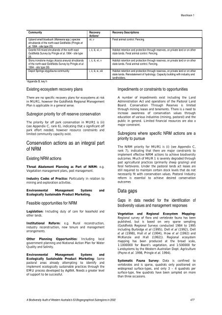
<strong>Murchison</strong> 1CommunityUpland small bluebush (Maireana spp.) speciesshrublands <strong>of</strong> the north-east Goldfields (Pringle etal. 1994 - site type 23)Granite hill mixed shrublands <strong>of</strong> the north-eastGoldfields Survey by Pringle et al. 1994 - site type25.Stony ironstone mulga (Acacia aneura) shrublands<strong>of</strong> the north-east Goldfields Survey by Pringle et al.1994 - site type 28)RecoveryActions 1vii, vRecovery DescriptionsFeral animal control. Fencing.i, ii, iii, vii, v Habitat retention and protection through reserves, on private land or on otherstate lands. Feral animal control. Fencing.i, ii, iii, vii, v Habitat retention and protection through reserves, on private land or on otherstate lands. Feral animal control. Fencing.Depot Springs styg<strong>of</strong>auna community i, ii, iii, xi, xiii Habitat retention and protection through reserves, on private land or on otherstate lands. Reinstatement <strong>of</strong> hydrology. Capacity building with industry andlandholders.1Appendix B, key hExisting ecosystem recovery plansThere are no specific recovery plans for ecosystems at riskin <strong>MUR1</strong>, however the Goldfields Regional ManagementPlan is applicable in a general sense.Subregion priority for <strong>of</strong>f reserve conservationThe priority for <strong>of</strong>f park conservation in <strong>MUR1</strong> is (ii)(see Appendix C, rank 6), indicating that a significant <strong>of</strong>fpark effort needed, however resource constraints andlimited community capacity exist.Conservation actions as an integral part<strong>of</strong> NRMExisting NRM actionsThreat Abatement Planning as Part <strong>of</strong> NRM: e.g.Vegetation management plans, pest management.Industry Codes <strong>of</strong> Practice: Particularly in relation tomining and exploration activities.Environmental Management Systems andEcologically Sustainable Product Marketing.Feasible opportunities for NRMLegislation: Including duty <strong>of</strong> care for leasehold andother lands.Institutional Reform: e.g. Rural reconstruction,industry reconstruction, new tenure and managementarrangements.Other Planning Opportunities: Including localgovernment planning and National Action Plan for WaterQuality and Salinity.Environmental Management Systems andEcologically Sustainable Product Marketing: Somepastoral areas already attempting to identify andimplement ecologically sustainable practices through theEMU process developed by AgWA. Needs a greater level<strong>of</strong> support to be successful.Impediments or constraints to opportunitiesA number <strong>of</strong> impediments exist including the LandAdministration Act and operations <strong>of</strong> the Pastoral LandBoard. Conservation Through Reserves is limitedthrough mining leases and tenements. There is a need toincrease awareness <strong>of</strong> conservation values througheducation <strong>of</strong> various industries (mining, pastoral) and thepublic in general. Limited financial resources are also amajor constraint.Subregions where specific NRM actions are apriority to pursueThe NRM priority for <strong>MUR1</strong> is (i) (see Appendix C,rank 7), indicating that there are major constraints toimplement effective NRM actions to achieve biodiversityoutcomes. Much <strong>of</strong> MUR 1 is severely degraded throughpast agricultural practices (primarily sheep grazing) andferal herbivores. Under the pastoral lands act leases arestill required to maintain certain stock levels that do notnecessarily fit with conservation values. Pastoral Industryreform is essential to achieve desired conservationoutcomesData gapsGaps in data needed for the identification <strong>of</strong>biodiversity values and management responsesVegetation and Regional Ecosystem Mapping:Regional survey <strong>of</strong> flora and vertebrate fauna has beenpublished, but is based on very sparse sampling(Goldfields Regional Surveys conducted 1984 to 1995including Burbidge et al (1995), Dell et al (1992), Dellet al (1998), Hall et al (1994), How et al (1992) andMcKenzie and Hall (1992)). Regional ecosystemmapping has been produced at the broad scale,1:1000000 for Beard’s vegetation, and 1:500000 forLandsystems by the Western Australian Dept. Agriculture(Payne et al. 1998, Pringle et al. 1994).Systematic Fauna Survey: Data is confined tovertebrates and is sparse, quadrats only positioned onwidespread surface-types, and only 3 <strong>–</strong> 4 quadrats persurface-type, few quadrats have been sampled on morethan three occasions.A Biodiversity Audit <strong>of</strong> Western Australia’s 53 Biogeographical Subregions in 2002 477


