Building Codes for City of Bellaire
Building Codes for City of Bellaire
Building Codes for City of Bellaire

Create successful ePaper yourself
Turn your PDF publications into a flip-book with our unique Google optimized e-Paper software.
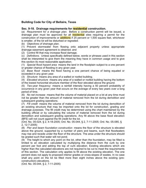
<strong>Building</strong> Code <strong>for</strong> <strong>City</strong> <strong>of</strong> <strong>Bellaire</strong>, TexasSec. 9-18. Drainage requirements <strong>for</strong> residential construction.(a) Requirement <strong>for</strong> a drainage plan. Be<strong>for</strong>e a construction permit will be issued, adrainage plan must be approved <strong>for</strong> all residential sites requiring a permit <strong>for</strong> theconstruction <strong>of</strong> improvements or additions if 25 percent or 1,500 square feet, whicheveris smaller, <strong>of</strong> the lot will be disturbed or regraded.(b) Objectives <strong>of</strong> drainage plan.(1) Prevent stormwater from flowing onto adjacent property unless appropriatedrainage easement agreement is obtained; and(2) Control fill that may increase flood damage.(c) Definitions. Unless specifically defined below, words or phrases used in this sectionshall be interpreted to give them the meaning they have in common usage and to givethis section its most reasonable application.(1) Special flood hazard area means the land in the floodplain subject to a one percentor greater chance <strong>of</strong> flooding in any given year.(2) Base flood means the flood having a one percent chance <strong>of</strong> being equaled orexceeded in any given year.(3) Structure means any area <strong>of</strong> a walled or ro<strong>of</strong>ed building.(4) Elevated structure means any area <strong>of</strong> a walled or ro<strong>of</strong>ed building having the bottom<strong>of</strong> the lowest horizontal structure member <strong>of</strong> the floor elevated above the ground.(5) Two-year frequency means a rainfall intensity having a 50 percent probability <strong>of</strong>occurrence in any given year that occurs on the average <strong>of</strong> every two years over a longperiod <strong>of</strong> time.(6) No net increase means that the volume <strong>of</strong> material placed on a lot at any time mustnot be greater than the amount <strong>of</strong> material removed from the lot during demolition andsubsequent grading operations.(7) Fill credit means the volume <strong>of</strong> material removed from the lot during demolition <strong>of</strong>an existing structure that may be imported onto the lot <strong>for</strong> construction, grading anddrainage purposes. The fill credit may be determined using the chart maintained by thebuilding <strong>of</strong>ficial or by calculating the volume <strong>of</strong> material removed from the lot duringdemolition and subsequent grading operations. Any fill above the base flood elevation(BFE) will not count against the fill credit <strong>for</strong> the lot.(Ord. No. 05-024, § 2, 4-18-2005; Ord. No. 05-044, § 2, 7-11-2005; Ord. No. 05-085, §2, 12-7-2005)(8) Pier and beam foundation construction means the floor <strong>of</strong> the structure is elevatedabove the ground, supported by a number <strong>of</strong> piers and beams, such that floodwatersmay rise and recede under the floor <strong>of</strong> the structure. The area under the structure shouldbe graded such that water will not pond.(9) The height to which any point on the lot, other than the foundation, may be filled islimited to an elevation calculated by multiplying the distance from the curb by onepercent per foot and adding the top <strong>of</strong> curb elevation. Existing elevations which arehigher than the calculated elevations are not required to be cut to meet the requirements<strong>of</strong> this section. The calculation only applies to fill above the existing elevation. The onepercent does not apply to proposed interior grades or cross-slopes <strong>of</strong> swales. In no caseshall any point on the lot be filled more than eight inches above the existing (preconstruction)elevations.(Ord. No. 05-044, § 2, 7-11-2005)
(10) A lot on which more than four inches <strong>of</strong> fill is placed shall be required to installpressure-treated rot boards or retaining walls on either side <strong>of</strong> the area in which the fillincreases the elevation <strong>of</strong> the lot above that <strong>of</strong> its neighbors. Rot board or retaining wallheight in front <strong>of</strong> the building line is limited to one inch above finished grade.(Ord. No. 05-044, § 2, 7-11-2005)(11) Yard Amenities are defined as pools, spas, fountains, waterfalls, outdoor kitchens,barbeque pits, fireplaces and other similar outdoor raised features. The one percent andeight inch maximum fill limit does not apply to yard amenities.(Ord. No. 05-085, § 2, 12-7-2005)(d) Contents <strong>of</strong> drainage plan.(1) Survey and elevation data. The drainage plan shall include data obtained by atopographical survey per<strong>for</strong>med under the supervision <strong>of</strong> and signed, sealed and datedby a pr<strong>of</strong>essional land surveyor registered in the State <strong>of</strong> Texas. The topographicalsurvey shall include as a minimum, the location and elevation <strong>of</strong> existing sidewalks,curb/gutters, ditches, storm sewers, sanitary sewers and the existing elevations <strong>of</strong> thelot. The survey should be completed prior to demolition <strong>of</strong> any structures on the propertyto provide baseline conditions to establish the fill credit <strong>for</strong> the property. The elevationsshall be based on the current datum and vertical benchmark system being used by thecity and should be at a maximum spacing <strong>of</strong> 20 feet throughout the property. The city willfurnish, upon request, location and elevation <strong>of</strong> benchmarks available within the city. Thedrainage plan shall show the proposed finished floor elevation and the finished gradeelevations <strong>of</strong> all proposed paving and grading on the site and shall include existing andplanned spot elevations at a maximum <strong>of</strong> 20 feet spacing covering the lot:a. Along the perimeter <strong>of</strong> the lot;b. Grid across the lot; andc. Finished floor and adjacent finished grade along the perimeter <strong>of</strong> all slabs, includingbut not limited to buildings, sidewalks, patios, driveways, and decks.(2) Requirement to drain. Drainage <strong>of</strong> the lot may be obtained by surface orsubsurface means, or a combination <strong>of</strong> the two, as is appropriate and necessary so thatthe stormwater falling on the residential lot upon which construction is planned will draininto the street, ditch or storm sewer system <strong>of</strong> the city and not onto adjacent property.However, as a minimum requirement, each lot will be required to provide drainage oneach side, or in the case <strong>of</strong> a corner lot, on the sides adjoining the adjacent lots,designated to carry the two year design storm, sloping to the street, ditch, or stormsewer. Cross sectional elevation <strong>of</strong> the swale shall be shown on the drainage plan atthree points: at the house, at the swale flow line, and at the side property line. Aminimum <strong>of</strong> three elevations are required to adequately define a swale cross section.The engineer preparing the drainage plan shall provide supporting calculations todemonstrate that the drainage system meets the design criteria. Cross sectionelevations <strong>of</strong> a swale shall be provided at the front property line, the front <strong>of</strong> the house,the midpoint <strong>of</strong> the house, the back <strong>of</strong> the house and at the beginning <strong>of</strong> the swale.(3) Limitation on lot fill <strong>for</strong> property located in the special flood hazard area.a. Option 1 - Elevated structure without fill. The proposed improvements to a propertyshall result in no net increase in volume <strong>of</strong> material on the lot with the exception <strong>of</strong> thesmall amount <strong>of</strong> concrete used <strong>for</strong> pier and beam foundation construction that may bepermitted by the building <strong>of</strong>ficial. The fill credit volume may be used to increase theelevation <strong>of</strong> the lot no more than the amount needed to create a maximum elevationequal to a one percent slope from the existing street, top <strong>of</strong> curb, edge <strong>of</strong> road (if no curbexists) or existing ditch high bank, but in no case shall more than eight inches <strong>of</strong> fill beallowed. The engineer preparing the drainage plan must provide calculations andsupporting data demonstrating that no net increase in volume <strong>of</strong> material is proposed.
. Option 2 - Elevated structure with fill. If the existing ground elevation at theproposed structure is equal to or above the base flood elevation (BFE) and the finishedfloor <strong>of</strong> the proposed structure will be elevated to one foot above the BFE by means <strong>of</strong>fill, then no additional fill on the lot will be allowed. Any volume <strong>of</strong> material used to raisethe existing lot elevation to the one percent or eight inch maximum fill limit <strong>for</strong> gradingand drainage purposes must be mitigated by lowering the finished grade below theexisting (pre-construction) elevation elsewhere on the lot. The engineer preparing thedrainage plan must provide calculations and supporting data demonstrating that no netincrease in volume <strong>of</strong> material is proposed with the exception <strong>of</strong> raising the finished floorto one foot above the BFE.(Ord. No. 05-024, § 2, 4-18-2005; Ord. No. 05-044, § 3, 7-11-2005)(4) Limitations on lot fill <strong>for</strong> property not located in the special flood hazard area. Lot fillshall be limited to no more than the amount necessary to achieve adequate drainagebased on generally accepted engineering design practices but no more than the amountneeded to create a maximum elevation equal to a one percent slope from the existingstreet, top <strong>of</strong> curb, edge <strong>of</strong> road (if no curb exists) or existing ditch high bank. In no caseshall more than eight inches <strong>of</strong> fill be allowed on any lot.(Ord. No. 05-024, § 2, 4-18-2005; Ord. No. 05-044, § 3, 7-11-2005)(5) Engineer's seal. The drainage plan shall be prepared, certified, sealed and signedby a civil engineer licensed as a pr<strong>of</strong>essional engineer in the State <strong>of</strong> Texas.(e) Certificate <strong>of</strong> occupancy. As a condition precedent to the issuance <strong>of</strong> any certificate<strong>of</strong> occupancy, a second topographical survey shall be made under the supervision <strong>of</strong> aregistered pr<strong>of</strong>essional land surveyor registered in the State <strong>of</strong> Texas which shall showthe "as-built" elevation <strong>of</strong> the residence and the finished grade elevations <strong>of</strong> the lot,patios, drives, sidewalks, landscaped areas, etc. The "as-built" survey shall be reviewedby a civil engineer licensed as a pr<strong>of</strong>essional engineer in the State <strong>of</strong> Texas. TheEngineer shall add the following statement to the "as-built" survey:I, ________________, a Pr<strong>of</strong>essional Engineer licensed in the State <strong>of</strong> Texas, havereviewed the "as-built" survey <strong>of</strong> this property and on the basis <strong>of</strong> that review that itcon<strong>for</strong>ms to the design and intent <strong>of</strong> the approved drainage plan submitted <strong>for</strong> permitand is in compliance with Chapter 9, <strong>Building</strong>s, Section 9-18, Drainage requirements <strong>for</strong>residential construction, <strong>of</strong> the Code <strong>of</strong> Ordinances <strong>of</strong> the <strong>City</strong> <strong>of</strong> <strong>Bellaire</strong>, Texas.TABLE INSET:__________(Date)__________(Seal & Signature)The <strong>Building</strong> Official shall deny a Certificate <strong>of</strong> Occupancy until the second topographicalsurvey showing "as-built" elevations and the Engineer's review statement have beenproperly submitted.(f) Duty to maintain drainage. All drainage improvements detailed in the drainage planmust be maintained to prevent stormwater run<strong>of</strong>f from flowing onto adjacent property.Interim measures to prevent stormwater from flowing onto adjacent properties shall beprovided and maintained during construction. It is the responsibility <strong>of</strong> the owner and allsubsequent owners to maintain the drainage on their property and to assure that noadditional fill is added over the amount in the approved drainage plan. No alterations tothe approved drainage plan shall be per<strong>for</strong>med without first having submitted a reviseddrainage plan and obtaining the proper approval. The city building <strong>of</strong>ficial shall maintaina copy <strong>of</strong> all drainage plans approved by the city.(g) Penalties. Any owner or agent <strong>of</strong> a residential building site or lot <strong>for</strong> which adrainage plan is required that fails to comply with, or is in violation <strong>of</strong>, any <strong>of</strong> the
equirements or provisions <strong>of</strong> this section, or fails to maintain the approved drainage,shall be subject to a fine in an amount not to exceed $500.00. Each day during whichany such violation is committed or continues shall be considered a separate <strong>of</strong>fense.(h) Variance.(1) Where a baseline fill credit does not exist, as in the case <strong>of</strong> remodeling or yardamenity addition, the building <strong>of</strong>ficial may allow excess fill credit <strong>for</strong> yard amenities,based upon the facts and circumstances <strong>of</strong> each application, as long as the objectives <strong>of</strong>the drainage plan continue to be met.(2) The building and standards commission <strong>of</strong> the city, upon application and hearing,shall have the power and authority to allow a variance from the requirements <strong>of</strong> thissection upon a finding that the strict application <strong>of</strong> the requirements <strong>of</strong> this section willaffect a hardship <strong>of</strong> the property and that the proposed design complies with the spiritand intent <strong>of</strong> this section and provides protection to the neighboring properties at leastequivalent to that provided by this section. The building and standards commission shallrequire that sufficient evidence or pro<strong>of</strong> be submitted to substantiate any claims that maybe made regarding such applications.(Ord. No. 05-024, § 2, 4-18-2005; Ord. No. 05-085, § 3, 12-7-2005)Sec. 9-34. Platting regulations.The owners <strong>of</strong> each attached one-family residence building site shall prepare andsubmit to the planning commission <strong>of</strong> the city <strong>for</strong> approval two plats <strong>of</strong> theproposed one-family residence subdivision, one setting <strong>for</strong>th all the mattersrequired to be set <strong>for</strong>th in the platting <strong>of</strong> a subdivision by state law, as amended,the dedications and acknowledgements required by that act, and the other shallalso show on such plat the dimensions and all <strong>of</strong> the matters required <strong>for</strong>attached one-family residences by this article and their dimensions, including,without limitation thereby, the location <strong>of</strong> all screening walls, streets, alleys,yards, lots, storage area, courtyard, parking area, living area, interior street,easement setback lines, utility line, fireplug, area <strong>for</strong> common use, and othermatters required or permitted by ordinance. Such owners shall endorse on suchplat a dedication and conveyance <strong>of</strong> all interior streets shown on such plat asindividual lots, and their owners then and hereafter, in equal undivided interests,as appurtenances running with the land. If the plats con<strong>for</strong>m to all therequirements <strong>of</strong> said state law and <strong>of</strong> chapter 24 <strong>of</strong> this Code, entitled "Planningand Zoning Regulations," as amended, they shall be approved by said planningand zoning commission; otherwise they shall be disapproved and no building oroccupancy permit shall be issued <strong>for</strong> any structure on such site.(Ord. No. 1970, § 1(j), 10-8-1973)Sec. 9-35. Drainage regulations.Be<strong>for</strong>e becoming entitled to a certificate <strong>of</strong> occupancy, an adequate drainagesystem, consisting <strong>of</strong> surface inlets with adequate sized rein<strong>for</strong>ced concrete pipe,shall be provided by the property owner to drain each property into the city'sstorm sewer system, in accordance with plans and specifications approved bythe building <strong>of</strong>ficial. The finished floor elevation <strong>of</strong> all buildings shall be at least 21
1/2 inches above the highest gutter elevation on streets adjacent to and abuttingupon each lot. All ro<strong>of</strong> drains and area drains must be guttered directly into thestorm sewer system.(Ord. No. 1970, § 1(k), 10-8-1973)Sec. 9-36. Landscaping and planting.Any portions <strong>of</strong> lots not required <strong>for</strong> buildings, entrances, sidewalks, or parkingareas shall be landscaped and planted with grass, shrubs and trees, and somaintained by the owners. Shrubs and trees shall not be planted over publicutility lines.(Ord. No. 1970, § 1(l), 10-8-1973)Sec. 9-37. Water and sewer regulations.Adequately sized circulating water lines <strong>of</strong> at least six inches in diameter shall beinstalled and connected with the city's lines, at owner's expense, <strong>for</strong> domesticuse and fire protection. Adequately sized sanitary sewer lines <strong>of</strong> eight inchesminimum to dispose <strong>of</strong> sanitary wastes shall also be installed and connected withthe city's sanitary sewer system, at the owner's expense. The developer shallfurnish plans and pr<strong>of</strong>iles <strong>of</strong> the sanitary sewers, storm sewers and water lines tobe dedicated to the city.(Ord. No. 1970, § 1(m), 10-8-1973)Sec. 9-38. <strong>Building</strong> foundations.The following requirements shall control new single-family developments:(1) The design <strong>of</strong> support on all bearing walls shall be footings drilled andreamed to boring clay.(2) The minimum nine-inch pier shall be rein<strong>for</strong>ced with a minimum <strong>of</strong> threeeach one-half inch diameter steel rods, tied with #2's top, center and bottom.(3) Post-tension slab design is prohibited.(4) Minimum concrete requirements are five sacks <strong>of</strong> cement per cubic yard <strong>of</strong>ready-mixed concrete.(Ord. No. 77-021, 4-4-1977; Ord. No. 85-043, § 15, 7-1-1985)Sec. 9-39. Additional requirements <strong>for</strong> new foundation construction.(a) The provisions <strong>of</strong> this section shall be applicable only to new foundationconstruction and shall not be applicable or affect foundation construction which iseither characterized as add-on and/or remodeling unless the addition is greaterthan 1,000 square feet or two stories in height.(b) Prior to the pouring <strong>of</strong> any concrete, a soil engineer shall inspect thecompaction, fill thickness verification, drilled footings, concrete and all otherareas deemed pertinent and shall carefully examine all <strong>of</strong> the pre-pouring workthat has been accomplished. Excess soil produced during the excavation <strong>for</strong>foundation piers and grade beams shall be removed from the site within twoweeks after placement <strong>of</strong> the concrete.(c) A soil compaction inspection and testing shall be per<strong>for</strong>med and shallinclude some grade testing and fill thickness. All fill soils shall be tested in lifts.
(d) A structural engineer shall review the initial soil engineer's report and designthe foundation accordingly. The structural engineer shall further inspect the workthat may be ongoing at any time and shall make as many inspections asnecessary to ensure compliance with design criteria.(e) Prior to the start <strong>of</strong> any further construction, the soil engineer and structuralengineer shall certify by letter to the <strong>City</strong> <strong>of</strong> <strong>Bellaire</strong> that the inspections as hereinrequired have been made and, based upon the review <strong>of</strong> data, that thefoundation as constructed and poured substantially con<strong>for</strong>ms to the design andthe intent <strong>of</strong> the soil exploration and foundation plan which has been submitted<strong>for</strong> a permit under other provisions <strong>of</strong> the Code <strong>of</strong> Ordinances <strong>of</strong> the <strong>City</strong> <strong>of</strong><strong>Bellaire</strong>.(f) For any crawl space, no wood products are allowed within 18 inches <strong>of</strong>grade.(g) For any crawl space, a minimum <strong>of</strong> two drains are required inside pier andbeam foundations to provide positive drainage. The drains are to be connected tothe lot drainage system. This drain system shall be included in the requireddrainage plan.(Ord. No. 97-027, § 39, 6-16-1997; Ord. No. 08-029, § 1(App. A), 6-16-2008)Secs. 9-40--9-43. Reserved.ARTICLE II-A. FLOOD DAMAGE PREVENTION*__________*Editor's note: The basis <strong>of</strong> this article is Ordinance No. 86-097, 12-15-1986, asamended.State law references: Local governments must adopt ordinances necessary <strong>for</strong>jurisdictions to qualify <strong>for</strong> National Flood Insurance Program, V.T.C.A., Water Code §16.3145; political subdivisions to comply with Federal standards, V.T.C.A., Water Code §16.315.__________DIVISION 1. STATUTORY AUTHORIZATION, FINDINGS OF FACT,PURPOSE AND METHODSSec. 9-70.1. Statutory authorization.The Legislature <strong>of</strong> the State <strong>of</strong> Texas has, in V.T.C.A., Water Code §§ 16.311--16.319 delegated the responsibility to local governmental units to adopt regulationsdesigned to minimize flood losses. There<strong>for</strong>e, the city council <strong>of</strong> the <strong>City</strong> <strong>of</strong> <strong>Bellaire</strong>,Texas, does ordain as set out in the following sections.Sec. 9-70.2. Findings <strong>of</strong> fact.(a) The flood hazard areas <strong>of</strong> the <strong>City</strong> <strong>of</strong> <strong>Bellaire</strong> are subject to periodic inundationwhich results in loss <strong>of</strong> life and property, health and safety hazards, disruption <strong>of</strong>commerce and governmental services, and extraordinary public expenditures <strong>for</strong> floodprotection and relief, all <strong>of</strong> which adversely affect the public health, safety and generalwelfare.
(b) These flood losses are created by the cumulative effect <strong>of</strong> obstructions infloodplains which cause an increase in flood heights and velocities, and by theoccupancy <strong>of</strong> flood hazard areas by uses vulnerable to floods and hazardous to otherlands because they are inadequately elevated, floodpro<strong>of</strong>ed or otherwise protected fromflood damage.Sec. 9-70.3. Statement <strong>of</strong> purpose.It is the purpose <strong>of</strong> this article to promote the public health, safety and generalwelfare and to minimize public and private losses due to flood conditions in specificareas by provisions designed to:(1) Protect human life and health;(2) Minimize expenditure <strong>of</strong> public money <strong>for</strong> costly flood control projects;(3) Minimize the need <strong>for</strong> rescue and relief ef<strong>for</strong>ts associated with flooding andgenerally undertaken at the expense <strong>of</strong> the general public;(4) Minimize prolonged business interruptions;(5) Minimize damage to public facilities and utilities such as water and gas mains,electric, telephone and sewer lines, streets and bridges located in floodplains;(6) Help maintain a stable tax base by providing <strong>for</strong> the sound use and development <strong>of</strong>floodprone areas in such a manner as to minimize future flood blight areas; and(7) Insure the potential buyers are notified that property is in a flood area.Sec. 9-70.4. Methods <strong>of</strong> reducing flood losses.In order to accomplish its purpose, this article uses the following methods:(1) Restrict or prohibit uses that are dangerous to health, safety or property in times <strong>of</strong>flood, or cause excessive increases in flood heights or velocities;(2) Require that uses vulnerable to floods, including facilities which serve such uses, beprotected against flood damage at the time <strong>of</strong> initial construction;(3) Control the alteration <strong>of</strong> natural floodplains, stream channels, and natural protectivebarriers, which are involved in the accommodation <strong>of</strong> floodwaters;(4) Control filling, grading, dredging and other development which may increase flooddamage;(5) Prevent or regulate the construction <strong>of</strong> flood barriers which will unnaturally divertfloodwaters or which may increase flood hazards to other lands.DIVISION 2. DEFINITIONS*__________*Editor's note: The basis <strong>for</strong> this division is Ordinance No. 87-012, § 1, 3-30-1987.__________Sec. 9-70.5. Definitions.Unless specifically defined below, words or phrases used in this article shall beinterpreted to give them the meaning they have in common usage and to give this articleits most reasonable application.(1) Alluvial fan flooding means flooding occurring on the surface <strong>of</strong> an alluvial fan orsimilar land<strong>for</strong>m which originates at the apex and is characterized by high-velocity flows;active processes <strong>of</strong> erosion, sediment transport, and deposition; and unpredictable flowpaths.(Ord. No. 00-028, 4-17-2000)
(2) Apex means a point on an alluvial fan or similar land<strong>for</strong>m below which the flow path<strong>of</strong> the major stream that <strong>for</strong>med the fan becomes unpredictable and alluvial fan floodingcan occur.(Ord. No. 00-028, 4-17-2000)(3) Appeal means a request <strong>for</strong> a review <strong>of</strong> the floodplain administrator's interpretation<strong>of</strong> any provision <strong>of</strong> this article or a request <strong>for</strong> a variance.(4) Appurtenant structure means a structure that is on the same parcel <strong>of</strong> property asthe principal structure to be insured and the use <strong>of</strong> which is incidental to the use <strong>of</strong> theprincipal structure.(5) Area <strong>of</strong> future conditions flood hazard means the land area that would be inundatedby the one percent annual chance (100-Year) flood based on future conditionshydrology.(6) Area <strong>of</strong> shallow flooding means a designated AO, AH, or VO zone on acommunity's Flood Insurance Rate Map (FIRM) with a one percent chance or greaterannual chance <strong>of</strong> flooding to an average depth <strong>of</strong> one to three (3) feet where a clearlydefined channel does not exist, where the path <strong>of</strong> flooding is unpredictable and wherevelocity flow may be evident. Such flooding is characterized by ponding or sheet flow.(7) Area <strong>of</strong> special flood hazard is the land in the floodplain within a community subjectto a one percent or greater chance <strong>of</strong> flooding in any given year. The area may bedesignated as Zone A on the Flood Hazard Boundary Map (FHBM). After detailedratemaking has been completed in preparation <strong>for</strong> the publication <strong>of</strong> the FIRM, Zone Ausually is refined into Zones A, AE, AH, AO, A1-99, VO, V1-30, VE or V.(8) Base flood means the flood having a one percent chance <strong>of</strong> being equaled orexceeded in any given year.(9) Basement means any area <strong>of</strong> the building having its floor subgrade (below groundlevel) on all sides.(10) Breakaway wall means a wall that is not part <strong>of</strong> the structural support <strong>of</strong> thebuilding and is intended through its design and construction to collapse under specificlateral loading <strong>for</strong>ces, without causing damage to the elevated portion <strong>of</strong> the building orsupporting foundation system.(11) Critical feature means an integral and readily identifiable part <strong>of</strong> a flood protectionsystem, without which the flood protection provided by the entire system would becompromised.(12) Development means any man-made change in improved and unimproved realestate, including but not limited to buildings or other structures, mining, dredging, filling,grading, paving, excavation or drilling operations or storage <strong>of</strong> equipment or materials.(13) Elevated building means a non-basement building: (i) built, in the case <strong>of</strong> abuilding in Zones A1-30, AE, A A99, AO, AH, B, C, X, and D, to have the top <strong>of</strong> theelevated floor, or in the case <strong>of</strong> a building in Zones V1-30, VE, or V, to have the bottom<strong>of</strong> the lowest horizontal structure members <strong>of</strong> the elevated floor elevated above theground level by means <strong>of</strong> pilings, columns (posts and piers), or shear walls parallel tothe floor <strong>of</strong> the water, and (ii) adequately anchored so as not to impair the structuralintegrity <strong>of</strong> the building during a flood <strong>of</strong> up to the magnitude <strong>of</strong> the base flood. In thecase <strong>of</strong> Zones A1-30, AE, A, A99, AO, AH, B, C, X, D, "elevated building" also includesa building elevated by means <strong>of</strong> fill or solid foundation perimeter walls with openingssufficient to facilitate the unimpeded movement <strong>of</strong> floodwaters. In the case <strong>of</strong> Zones V1-30, VE, or V, "elevated building" also includes a building otherwise meeting the definition<strong>of</strong> "elevated building," even though the lower area is enclosed by means <strong>of</strong> breakawaywalls if the breakaway walls meet the standards <strong>of</strong> Section 60.3(e)(5) <strong>of</strong> the NationalFlood Insurance Program regulations.
(14) Existing construction means <strong>for</strong> the purposes <strong>of</strong> determining rates, structures <strong>for</strong>which the "start <strong>of</strong> construction" commenced be<strong>for</strong>e the effective date <strong>of</strong> the FIRM orbe<strong>for</strong>e January 1, 1975, <strong>for</strong> FIRMs effective be<strong>for</strong>e that date. "Existing construction" mayalso be referred to as "existing structures."(15) Existing manufactured home park or subdivision means a manufactured homepark or subdivision <strong>for</strong> which the construction <strong>of</strong> facilities <strong>for</strong> servicing the lots on whichthe manufactured homes are to be affixed (including, at a minimum, the installation <strong>of</strong>utilities, the construction <strong>of</strong> streets, and either final site grading or the pouring <strong>of</strong>concrete pads) is completed be<strong>for</strong>e the effective date <strong>of</strong> the floodplain managementregulations adopted by a community.(16) Expansion to an existing manufactured home park or subdivision means thepreparation <strong>of</strong> additional sites by the construction <strong>of</strong> facilities <strong>for</strong> servicing the lots onwhich the manufactured homes are to be affixed (including the installation <strong>of</strong> utilities, theconstruction <strong>of</strong> streets, and either final site grading or the pouring <strong>of</strong> concrete pads).(17) Flood or flooding means a general and temporary condition <strong>of</strong> partial or completeinundation <strong>of</strong> normally dry land areas from:a. The overflow <strong>of</strong> inland or tidal waters;b. The unusual and rapid accumulation or run<strong>of</strong>f <strong>of</strong> surface waters from any source.(18) Flood elevation study means an examination, evaluation and determination <strong>of</strong>flood hazards and, if appropriate, corresponding water surface elevation, or anexamination, evaluation and determination <strong>of</strong> mudslide (i.e., mudflow) and/or floodrelatederosion hazards.(19) Flood Insurance Rate Map (FIRM) means an <strong>of</strong>ficial map <strong>of</strong> a community onwhich the Federal Emergency Management Agency has delineated both the areas <strong>of</strong>special flood hazards and the risk premium zones applicable to the community.(20) Flood Insurance Study (FIS) is the <strong>of</strong>ficial report provided by the FederalEmergency Management Agency. The report contains flood pr<strong>of</strong>iles, water surfaceelevation <strong>of</strong> the base flood, as well as the flood boundary-floodway map.(21) Floodplain or flood-prone area means any land area susceptible to beinginundated by water from any source (see definition <strong>of</strong> flooding).(22) Floodplain management means the operation <strong>of</strong> an overall program <strong>of</strong> correctiveand preventive measures <strong>for</strong> reducing flood damage, including but not limited toemergency preparedness plans, flood control works and floodplain managementregulations.(23) Floodplain management regulations means zoning ordinances, subdivisionregulations, building codes, health regulations, special purpose ordinances (such as afloodplain ordinance, grading ordinance and erosion control ordinance) and otherapplications <strong>of</strong> police power. The term describes such state or local regulations, in anycombination there<strong>of</strong>, which provide standards <strong>for</strong> the purpose <strong>of</strong> flood damageprevention and reduction.(Ord. No. 00-028, 4-17-2000)(24) Floodpro<strong>of</strong>ing means any combination <strong>of</strong> structural and non-structural additions,changes, or adjustments to structures which reduce or eliminate flood damage to realestate or improved real property, water and sanitary facilities, structures and theircontents.(Ord. No. 00-028, 4-17-2000)(25) Flood protection system means those physical structural works <strong>for</strong> which fundshave been authorized, appropriated, and expended and which have been constructedspecifically to modify flooding in order to reduce the extent <strong>of</strong> the areas within acommunity subject to a "special flood hazard" and the extent <strong>of</strong> the depths <strong>of</strong> associatedflooding. Such a system typically includes hurricane tidal barriers, dams, reservoirs,
levees or dikes. The specialized flood modifying works are those constructed incon<strong>for</strong>mance with sound engineering standards.(26) Floodway (regulatory floodway) means the channel <strong>of</strong> a river or other watercourseand the adjacent land area that must be reserved in order to discharge the base floodwithout cumulatively increasing the water surface elevation more than a designatedheight.(Ord. No. 00-028, 4-17-2000)(27) Functionally dependent use means a use which cannot per<strong>for</strong>m its intendedpurpose unless it is located or carried out in close proximity to water. The term includesonly docking facilities, port facilities that are necessary <strong>for</strong> the loading and unloading <strong>of</strong>cargo or passengers, and ship building and ship repair facilities, but does not includelong-term storage or related manufacturing facilities.(28) Highest adjacent grade means the highest natural elevation <strong>of</strong> the ground surfaceprior to construction next to the proposed walls <strong>of</strong> a structure.(29) Historic structure means any structure that is:(a) Listed individually in the National Register <strong>of</strong> Historic Places (a listing maintained bythe Department <strong>of</strong> Interior) or preliminarily determined by the Secretary <strong>of</strong> the Interior asmeeting the requirements <strong>for</strong> individual listing on the National Register;(b) Certified or preliminarily determined by the Secretary <strong>of</strong> the Interior as contributingto the historical significance <strong>of</strong> a registered historic district or a district preliminarilydetermined by the secretary to qualify as a registered historic district;(c) Individually listed on a state inventory <strong>of</strong> historic places in states with historicpreservation programs which have been approved by the Secretary <strong>of</strong> Interior; or(d) Individually listed on a local inventory or historic places in communities with historicpreservation programs that have been certified either:(1) By an approved state program as determined by the Secretary <strong>of</strong> the Interior; or(2) Directly by the Secretary <strong>of</strong> the Interior in states without approved programs.(30) Levee means a man-made structure, usually an earthen embankment, designedand constructed in accordance with sound engineering practices to contain, control ordivert the flow <strong>of</strong> water so as to provide protection from temporary flooding.(31) Levee system means a flood protection system which consists <strong>of</strong> a levee, orlevees, and associated structures, such as closure and drainage devices, which areconstructed and operated in accordance with sound engineering practices.(32) Lowest floor means the lowest floor <strong>of</strong> the lowest enclosed area (includingbasement). An unfinished or flood resistant enclosure, used solely <strong>for</strong> parking vehicles,building access or storage in an area other than the basement area is not considered abuilding's lowest floor, provided that such enclosure is not built so as to render thestructure in violation <strong>of</strong> the applicable non-elevation design requirement <strong>of</strong> Section 60.3<strong>of</strong> the National Flood Insurance Program regulations. For residential structures without abasement, the lowest floor elevation shall be measured as follows: a) <strong>for</strong> concrete slabconstruction, the lowest floor elevation shall be measured by the surface <strong>of</strong> the lowestpoint on the exterior perimeter <strong>of</strong> the slab, excluding any ledges solely <strong>for</strong> the purpose <strong>of</strong>attaching a facade; and b) <strong>for</strong> crawl space (pier and beam) construction, the lowest floorelevation shall be measured by the top <strong>of</strong> the wood sub-flooring. For residentialstructures with a basement, the lowest floor elevation shall be measured by the topsurface <strong>of</strong> the basement floor at the lowest point. For the purpose <strong>of</strong> this regulation, winecellars and elevator pits are regarded as basements.(Ord. No. 05-043, § 2, 7-11-2005)(33) Manufactured home means a structure transportable in one or more sections,which is built on a permanent chassis and is designed <strong>for</strong> use with or without a
permanent foundation when connected to the required utilities. The term "manufacturedhome" does not include a "recreational vehicle."(Ord. No. 00-028, 4-17-2000)(34) Manufactured home park or subdivision means a parcel (or contiguous parcels)<strong>of</strong> land divided into two (2) or more manufactured home lots <strong>for</strong> rent or sale.(35) Mean sea level means, <strong>for</strong> purposes <strong>of</strong> the National Flood Insurance Program, theNational Geodetic Vertical Datum (NGVD) <strong>of</strong> 1929 or other datum, to which base floodelevations shown on a community's Flood Insurance Rate Map are referenced.(36) New construction means, <strong>for</strong> floodplain management purposes, structures <strong>for</strong>which the "start <strong>of</strong> construction" commenced on or after the effective date <strong>of</strong> a floodplainmanagement regulation adopted by a community.(37) New manufactured home park or subdivision means a manufactured home parkor subdivision <strong>for</strong> which the construction <strong>of</strong> facilities <strong>for</strong> servicing the lots on which themanufactured homes are to be affixed (including at a minimum, the installation <strong>of</strong>utilities, the construction <strong>of</strong> streets, and either final site grading or the pouring <strong>of</strong>concrete pads) is completed on or after the effective date <strong>of</strong> floodplain managementregulations adopted by a community.(38) Recreational vehicle means a vehicle which is (i) built on a single chassis; (ii) fourhundred (400) square feet or less when measured at the largest horizontal projections;(iii) designed to be self-propelled or permanently towable by a light duty truck; and (iv)designed primarily not <strong>for</strong> use as a permanent dwelling but as temporary living quarters<strong>for</strong> recreational, camping, travel, or seasonal use.(39) Riverine means relating to, <strong>for</strong>med by, or resembling a river (including tributaries),stream, brook, etc.(40) Start <strong>of</strong> construction (<strong>for</strong> other than new construction or substantial improvementsunder the Coastal Barrier Resources Act (Pub. L. 97-348)), includes substantialimprovement and means the date the building permit was issued, provided the actualstart <strong>of</strong> construction, repair, reconstruction, rehabilitation, addition, placement, or otherimprovement was within one hundred eighty (180) days <strong>of</strong> the permit date. The actualstart means either the first placement <strong>of</strong> permanent construction <strong>of</strong> a structure on a site,such as the pouring <strong>of</strong> slab or footings, the installation <strong>of</strong> piles, the construction <strong>of</strong>columns, or any work beyond the stage <strong>of</strong> excavation; or the placement <strong>of</strong> amanufactured home on a foundation. Permanent construction does not include landpreparation, streets and/or walkways; nor does it include excavation <strong>for</strong> basement,footings, piers or foundations or the erection <strong>of</strong> temporary <strong>for</strong>ms; nor does it include theinstallation <strong>of</strong> streets and/or walkways; nor does it include excavation <strong>for</strong> basement,include the installation on the property <strong>of</strong> accessory buildings, such as garages or shedsnot occupied as dwelling units or not part <strong>of</strong> the main structure. For a substantialimprovement, the actual start <strong>of</strong> construction means the first alteration <strong>of</strong> any wall,ceiling, floor, or other structural part <strong>of</strong> a building, whether or not that alteration affectsthe external dimensions <strong>of</strong> the building.(Ord. No. 00-028, 4-17-2000)(41) Structure means a walled and ro<strong>of</strong>ed building, including a gas or liquid storagetank, which is principally above ground, as well as a manufactured home.(42) Substantial damage means damage <strong>of</strong> any origin sustained by a structurewhereby the cost <strong>of</strong> restoring the structure to its be<strong>for</strong>e damaged condition would equalor exceed fifty (50) percent <strong>of</strong> the market value <strong>of</strong> the structure be<strong>for</strong>e the damageoccurred.(43) Substantial improvement means any reconstruction, rehabilitation, addition, orother improvement <strong>of</strong> a structure, the cost <strong>of</strong> which equals or exceeds fifty (50) percent<strong>of</strong> the market value <strong>of</strong> the structure be<strong>for</strong>e "start <strong>of</strong> construction" <strong>of</strong> the improvement.
This includes structures which have incurred "substantial damage," regardless <strong>of</strong> theactual repair work per<strong>for</strong>med. The term does not, however, include either: (1) any project<strong>for</strong> improvement <strong>of</strong> a structure to correct existing violations <strong>of</strong> state or local health,sanitary, or safety code specifications which have been identified by the local codeen<strong>for</strong>cement <strong>of</strong>ficial and which are the minimum necessary conditions; or (2) anyalteration <strong>of</strong> a "historic structure," provided that the alteration will not preclude thestructure's continued designation as a 'historic structure.'(44) Variance is a grant <strong>of</strong> relief to a person from the requirements <strong>of</strong> this article whenspecific en<strong>for</strong>cement would result in unnecessary hardship. A variance, there<strong>for</strong>e,permits construction or development in a manner otherwise prohibited by this article.(For full requirements, see Section 60.6 <strong>of</strong> the National Flood Insurance Programregulations.)(45) Violation means the failure <strong>of</strong> a structure or other development to be fullycompliant with the community's floodplain management regulations. A structure or otherdevelopment without the elevation certificate, other certifications or other evidence <strong>of</strong>compliance required in section 60.3(b)(5), (c)(4), (c)(10), (d)(3), (e)(2), (e)(4) or (e)(5) <strong>of</strong>the National Flood Insurance Program regulations is presumed to be in violation untilsuch time as that documentation is provided.(46) Water surface elevation means the height, in relation to the National GeodeticVertical Datum (NGVD) <strong>of</strong> 1929 (or other datum, where specified), <strong>of</strong> floods <strong>of</strong> variousmagnitudes and frequencies in the floodplains <strong>of</strong> coastal or riverine areas.(Ord. No. 96-063, 11-4-1996; Ord. No. 00-028, 4-17-2000; Ord. No. 07-063, § 1(App. A),11-5-07)DIVISION 3. GENERAL PROVISIONSSec. 9-70.6. Lands to which this article applies.This article shall apply to all areas <strong>of</strong> special flood hazard within the jurisdiction <strong>of</strong>the <strong>City</strong> <strong>of</strong> <strong>Bellaire</strong>.Sec. 9-70.7. Basis <strong>for</strong> establishing the areas <strong>of</strong> special flood hazard.The areas <strong>of</strong> special flood hazard identified by the Federal EmergencyManagement Agency in a scientific and engineering report entitled "The Flood InsuranceStudy (FIS) <strong>for</strong> the <strong>City</strong> <strong>of</strong> <strong>Bellaire</strong>, Texas," dated June 28, 2007, with accompanyingFlood Insurance Rate Maps and Flood Boundary-Floodway Maps (FIRM and FBFM) andany revisions thereto are hereby adopted by reference and declared to be a part <strong>of</strong> thisarticle.(Ord. No. 96-063, 11-4-1996; Ord. No. 00-028, 4-17-2000; Ord. No. 04-032, § 2, 6-7-2004; Ord. No. 07-063, § 1(App. A), 11-5-07)Sec. 9-70.8. Establishment <strong>of</strong> development permit.A development permit shall be required in the floodplain to ensure con<strong>for</strong>mancewith the provisions <strong>of</strong> this article.(Ord. No. 07-063, § 1(App. A), 11-5-07)Sec. 9-70.9. Compliance.No structure or land shall hereafter be located, altered or have its use changedwithout full compliance with the terms <strong>of</strong> this article and other applicable regulations.Sec. 9-70.10. Abrogation and greater restrictions.
This article is not intended to repeal, abrogate or impair any existing easements,covenants or deed restrictions. However, where this article and another ordinanceconflict or overlap, whichever imposes the more stringent restrictions shall prevail.(Ord. No. 87-012, § 2, 3-30-1987)Sec. 9-70.11. Interpretation.In the interpretation and application <strong>of</strong> this Article, all provisions shall be: (1)considered as minimum requirements; (2) liberally construed in favor <strong>of</strong> the governingbody; and (3) deemed neither to limit nor repeal any other powers granted under statestatutes.Sec. 9-70.12. Warning and disclaimer <strong>of</strong> liability.The degree <strong>of</strong> flood protection required by this article is considered reasonable<strong>for</strong> regulatory purposes and is based on scientific and engineering considerations. Onrare occasions greater floods can and will occur and flood heights may be increased byman-made or natural causes. This article does not imply that land outside the areas <strong>of</strong>special flood hazards or uses permitted within such areas will not be free from floodingor flood damages. This article shall not create liability on the part <strong>of</strong> the community orany <strong>of</strong>ficial or employee there<strong>of</strong> <strong>for</strong> any flood damages that result from reliance on thisarticle or any administrative decision lawfully made hereunder.DIVISION 4. ADMINISTRATIONSec. 9-70.13. Designation <strong>of</strong> the floodplain administrator.The building <strong>of</strong>ficial is hereby appointed the floodplain administrator to administerand implement the provisions <strong>of</strong> this article and other appropriate sections <strong>of</strong> 44 CFR(National Flood Insurance Program regulations) pertaining to floodplain management.(Ord. No. 87-012, § 3, 3-30-1987)Sec. 9-70.14. Duties and responsibilities <strong>of</strong> the floodplain administrator.Duties and responsibilities <strong>of</strong> the floodplain administrator shall include, but not belimited to, the following:(1) Maintain and hold open <strong>for</strong> public inspection all records pertaining to the provisions<strong>of</strong> this article;(2) Review permit applications to determine whether proposed building sites will bereasonably safe from flooding;(3) Review, approve or deny all applications <strong>for</strong> development permits required byadoption <strong>of</strong> this article;(4) Review permits <strong>for</strong> proposed development to assure that all necessary permits havebeen obtained from those federal, state or local governmental agencies (includingsection 404 <strong>of</strong> the Federal Water Pollution Control Act Amendments <strong>of</strong> 1972, 33 USC1334) from which prior approval is required;(5) Where interpretation is needed as to the exact location <strong>of</strong> the boundaries <strong>of</strong> theareas <strong>of</strong> special flood hazards (<strong>for</strong> example, where there appears to be a conflictbetween a mapped boundary and actual field conditions), the floodplain administratorshall make the necessary interpretation;(6) Notify, in riverine situations, adjacent communities and the State CoordinatingAgency which is Texas Commission on Environmental Quality, prior to any alteration orrelocation <strong>of</strong> a watercourse, and submit evidence <strong>of</strong> such notification to the FederalEmergency Management Agency;
(7) Assure that the flood carrying capacity within the altered or relocated portion <strong>of</strong> anywatercourse is maintained;(8) When base flood elevation data has not been provided in accordance with division3, section 9-70.7, the floodplain administrator shall obtain, review and reasonably utilizeany base flood elevation data and floodway data available from federal, state or othersource, in order to administer the provisions <strong>of</strong> division 5;(9) When a regulatory floodway has not been designated, the floodplain administratormust require that no new construction, substantial improvements or other development(including fill) shall be permitted within Zones A1-30 and AE on the community's FIRM,unless it is demonstrated that the cumulative effect <strong>of</strong> the proposed development, whencombined with all other existing and anticipated development, will not increase the watersurface elevation <strong>of</strong> the base flood more than one foot at any one point within thecommunity;(10) Under the provisions <strong>of</strong> 44 CFR chapter 1, § 65.12, <strong>of</strong> the National FloodInsurance Program regulations, a community may approve certain development inZones A1-30, AE, AH, on the community's FIRM which increases the water surfaceelevation <strong>of</strong> the base flood by more than one foot, provided that the community firstapplies <strong>for</strong> a conditional FIRM revision through FEMA.(Ord. No. 87-012, § 4, 3-30-1987; Ord. No. 96-063, 11-4-1996)Sec. 9-70.15. Permit procedures.(a) Application <strong>for</strong> a development permit in the floodplain shall be presented to thefloodplain administrator on <strong>for</strong>ms furnished by him and may include, but not be limited to,plans in duplicate drawn to scale showing the location, dimensions and elevation <strong>of</strong>proposed landscape alterations, existing and proposed structures, and the location <strong>of</strong>the <strong>for</strong>egoing in relation to areas <strong>of</strong> special flood hazard. Additionally, the followingin<strong>for</strong>mation is required:(1) Elevation (in relation to mean sea level) <strong>of</strong> the lowest floor (including basement) <strong>of</strong>all new and substantially improved structures;(2) Elevation in relation to mean sea level to which any nonresidential structure shall befloodpro<strong>of</strong>ed;(3) A certificate from a registered pr<strong>of</strong>essional engineer or architect that thenonresidential floodpro<strong>of</strong>ed structure shall meet the floodpro<strong>of</strong>ing criteria <strong>of</strong> division 5,section 9-70.18, subsection (2);(4) Description <strong>of</strong> the extent to which any watercourse or natural drainage will bealtered or relocated as a result <strong>of</strong> proposed development;(5) Maintain a record <strong>of</strong> all such in<strong>for</strong>mation in accordance with division 4, section 9-70.14, subsection (1).(b) Approval or denial <strong>of</strong> a development permit by the floodplain administrator shall bebased on all <strong>of</strong> the provisions <strong>of</strong> this article and the following relevant factors:(1) The danger to life and property due to flooding or erosion damage;(2) The susceptibility <strong>of</strong> the proposed facility and its contents to flood damage and theeffect <strong>of</strong> such damage on the individual owner;(3) The danger that materials may be swept onto other lands to the injury <strong>of</strong> others;(4) The compatibility <strong>of</strong> the proposed use with existing and anticipated development;(5) The safety <strong>of</strong> access to the property in times <strong>of</strong> flood <strong>for</strong> ordinary and emergencyvehicles;(6) The costs <strong>of</strong> providing governmental services during and after flood conditionsincluding maintenance and repair <strong>of</strong> streets and bridges, and public utilities and facilitiessuch as sewer, gas, electrical and water systems;
(7) The expected heights, velocity, duration, rate <strong>of</strong> rise and sediment transport <strong>of</strong> thefloodwaters and the effects <strong>of</strong> wave action, if applicable, expected at the site;(8) The necessity to the facility <strong>of</strong> a waterfront location, where applicable;(9) The availability <strong>of</strong> alternative locations, not subject to flooding or erosion damage,<strong>for</strong> the proposed use;(10) The relationship <strong>of</strong> the proposed use to the comprehensive plan <strong>for</strong> that area.(Ord. No. 87-012, § 5, 3-30-1987)Sec. 9-70.16. Variance procedures.(a) The building and standards commission, as established by the <strong>City</strong> <strong>of</strong> <strong>Bellaire</strong>, shallhear and render judgment on requests <strong>for</strong> variances from the requirements <strong>of</strong> this article.(b) The building and standards commission shall hear and render judgment on anappeal only when it is alleged there is an error in any requirement, decision ordetermination made by the floodplain administrator in the en<strong>for</strong>cement or administration<strong>of</strong> this article.(c) Any person or persons aggrieved by the decision <strong>of</strong> the building and standardscommission may appeal such decision in the courts <strong>of</strong> competent jurisdiction.(d) The building <strong>of</strong>ficial shall maintain a record <strong>of</strong> all actions involving an appeal andshall report variances to the Federal Emergency Management Agency upon request.(e) Variances may be issued <strong>for</strong> the reconstruction, rehabilitation or restoration <strong>of</strong>structures listed on the National Register <strong>of</strong> Historic Places or the state inventory <strong>of</strong>historic places, without regard to the procedures set <strong>for</strong>th in the remainder <strong>of</strong> this article.(f) Generally, variances may be issued <strong>for</strong> new construction and substantialimprovements to be erected on a lot <strong>of</strong> one-half acre or less in size contiguous to andsurrounded by lots with existing structures constructed below the base flood level,providing the relevant factors in section 9-70.15, subsection (b) <strong>of</strong> this division havebeen fully considered. As the lot size increases beyond the one-half acre, the technicaljustification required <strong>for</strong> issuing the variance increases.(g) Upon consideration <strong>of</strong> the factors noted above and the intent <strong>of</strong> this article, thebuilding and standards commission may attach such conditions to the granting <strong>of</strong>variances as it deems necessary to further the purpose and objectives <strong>of</strong> this article(division 1, section 9-70.3).(h) Variances shall not be issued within any designated floodway if any increase inflood levels during the base flood discharge would result.(i) Variances may be issued <strong>for</strong> the repair or rehabilitation <strong>of</strong> historic structures upon adetermination that the proposed repair or rehabilitation will not preclude the structure'scontinued designation as a historic structure and the variance is the minimum necessaryto preserve the historic character and design <strong>of</strong> the structure.(j) Prerequisites <strong>for</strong> granting variances:(1) Variances shall only be issued upon a determination that the variance is theminimum necessary, considering the flood hazard, to af<strong>for</strong>d relief.(2) Variances shall only be issued upon: (i) showing a good and sufficient cause, (ii) adetermination that failure to grant the variance would result in exceptional hardship tothe applicant, and (iii) a determination that the granting <strong>of</strong> a variance will not result inincreased flood heights, additional threats to public safety, extraordinary public expense,create nuisances, cause fraud on or victimization <strong>of</strong> the public, or conflict with existinglocal laws, this Code or other ordinances.(3) Any applicant to whom a variance is granted shall be given written notice that thestructure will be permitted to be built with the lowest floor elevation below the base floodelevation, and that the cost <strong>of</strong> flood insurance will be commensurate with the increasedrisk resulting from the reduced lowest floor elevation.
(k) Variances may be issued by a community <strong>for</strong> new construction and substantialimprovements and <strong>for</strong> other development necessary <strong>for</strong> the conduct <strong>of</strong> a functionallydependent use provided that: (i) the criteria outlined in subsections (a) through (i) <strong>of</strong> thissection are met, and (ii) the structure or other development is protected by methods thatminimize flood damages during the base flood and create no additional threats to publicsafety.(Ord. No. 96-063, 11-4-1996)DIVISION 5. PROVISIONS FOR FLOOD HAZARD REDUCTIONSec. 9-70.17. General standards.In all areas <strong>of</strong> special flood hazards, the following provisions are required <strong>for</strong> allnew construction and substantial improvements:(1) All new construction or substantial improvements shall be designed (or modified)and adequately anchored to prevent flotation, collapse or lateral movement <strong>of</strong> thestructure resulting from hydrodynamic and hydrostatic loads, including the effects <strong>of</strong>buoyancy;(2) All new construction or substantial improvements shall be constructed by methodsand practices that minimize flood damage;(3) All new construction or substantial improvements shall be constructed withmaterials resistant to flood damage;(4) All new construction or substantial improvements shall be constructed withelectrical, heating, ventilation, plumbing and air conditioning equipment and otherservice facilities that are designed and/or located so as to prevent water from entering oraccumulating within the components during conditions <strong>of</strong> flooding;(5) All new and replacement water supply systems shall be designed to minimize oreliminate infiltration <strong>of</strong> floodwaters into the system;(6) New and replacement sanitary sewage systems shall be designed to minimize oreliminate infiltration <strong>of</strong> floodwaters into the system and discharge from the system int<strong>of</strong>loodwaters; and(7) On-site waste disposal systems shall be located to avoid impairment to them orcontamination from them during flooding.(Ord. No. 87-012, § 7, 3-30-1987)Sec. 9-70.18. Specific standards.In all areas <strong>of</strong> special flood hazards where base flood elevation data has beenprovided as set <strong>for</strong>th in division 3, section 9-70.7, division 4, section 9-70.14, subsection(8), or division 5, section 9-70.19, subsection (d), the following provisions are required:(1) Residential construction. New construction and substantial improvement <strong>of</strong> anyresidential structure shall have the lowest floor (including basement) elevated as aminimum, to one foot above the highest <strong>of</strong> the base flood elevation shown on theeffective FIRM and the Flood Hazard Recovery Data Map. A registered pr<strong>of</strong>essionalengineer, architect or land surveyor shall submit a certification to the floodplainadministrator that the standard <strong>of</strong> this subsection, as proposed in division 4, section 9-70.15, subsection (a)(1), is satisfied.(Ord. No. 04-032, § 3, 6-7-2004)(2) Nonresidential construction. New construction and substantial improvement <strong>of</strong> anycommercial, industrial or other nonresidential structure shall either have the lowest floor(including basement) elevated to one foot above the highest <strong>of</strong> the base flood elevationshown on the effective FIRM and the Flood Hazard Recovery Data Map or, together with
attendant utility and sanitary facilities, be designed so that below the base flood level thestructure is watertight with walls substantially impermeable to the passage <strong>of</strong> water andwith structural components having the capability <strong>of</strong> resisting hydrostatic andhydrodynamic loads and effects <strong>of</strong> buoyancy. A registered pr<strong>of</strong>essional engineer orarchitect shall develop and/or review structural design, specifications and plans <strong>for</strong> theconstruction, and shall certify that the design and methods <strong>of</strong> construction are inaccordance with accepted standards <strong>of</strong> practice as outlined in this subsection. A record<strong>of</strong> such certification which includes the specific elevation (in relation to mean sea level)to which such structures are floodpro<strong>of</strong>ed shall be maintained by the floodplainadministrator.(Ord. No. 04-032, § 3, 6-7-2004)(3) Enclosures. New construction and substantial improvements, with fully enclosedareas below the lowest floor that are usable solely <strong>for</strong> parking <strong>of</strong> vehicles, buildingaccess or storage in an area other than a basement and hydrostatic flood <strong>for</strong>ces onexterior walls by allowing <strong>for</strong> the entry and exit by a registered pr<strong>of</strong>essional engineer orarchitect or meet or exceed the following minimum criteria:a. A minimum <strong>of</strong> two openings having a total net area <strong>of</strong> not less than one square inch<strong>for</strong> every square foot <strong>of</strong> enclosed area subject to flooding shall be provided;b. The bottom <strong>of</strong> all openings shall be no higher than four inches above grade;(Ord. No. 05-045, § 2, 7-11-2005)c. Openings may be equipped with screens, louvers, valves or other coverings ordevices provided that they permit the automatic entry and exit <strong>of</strong> floodwaters.(Ord. No. 00-028, 4-17-2000)(4) Manufactured homes.a. Require that all manufactured homes to be placed within Zone A on a community'sFHBM or FIRM shall be installed using methods and practices which minimize flooddamage. For the purpose <strong>of</strong> this requirement, manufactured homes must be elevatedand anchored to resist flotation, collapse or lateral movement. Methods <strong>of</strong> anchoringmay include, but are not limited to, use <strong>of</strong> over-the-top or frame ties to ground anchors.This requirement is in addition to applicable State and local anchoring requirements <strong>for</strong>resisting wind <strong>for</strong>ces.b. Require that manufactured homes that are placed or substantially improved withinZones A1-30, AH, and AE on the community's FIRM on sites: (i) outside <strong>of</strong> amanufactured home park or subdivision, (ii) in a new manufactured home park orsubdivision, (iii) in an expansion to an existing manufactured home park or subdivision,or (iv) in an existing manufactured home park or subdivision on which a manufacturedhome has incurred "substantial damage" as a result <strong>of</strong> a flood, be elevated on apermanent foundation such that the lowest floor <strong>of</strong> the manufactured home is elevated toor above the base flood elevation and be securely anchored to an adequately anchoredfoundation system to resist flotation, collapse, and lateral movement.c. Require that all manufactured homes be placed or substantially improved on sites inan existing manufactured home park or subdivision with Zones A1-30, AH and AE on thecommunity's FIRM that are not subject to the provision <strong>of</strong> subpart (4) <strong>of</strong> this section beelevated so that either:(i) The manufactured home shall have the lowest floor elevated as a minimum, to onefoot above the highest <strong>of</strong> the base flood elevation shown on the effective FIRM and theFlood Hazard Recovery Data Maps flood elevation, or(ii) The manufactured home chassis is supported by rein<strong>for</strong>ced piers or otherfoundation elements <strong>of</strong> at least equivalent strength that are no less than 36 inches inheight above grade and be securely anchored to an adequately anchored foundationsystem to resist flotation, collapse, and lateral movement.
(5) Recreational vehicles. Require that recreational vehicles placed on sites withinZones A1-30, AH, and AE on the community's FIRM either: (i) be on the site <strong>for</strong> fewerthan 180 consecutive days, (ii) be fully licensed and ready <strong>for</strong> highway use, or (iii) meetthe permit requirements <strong>of</strong> article 4, section C(1), and the elevation and anchoringrequirements <strong>for</strong> "manufactured homes" in subsection (4) <strong>of</strong> this section. A recreationalvehicle is ready <strong>for</strong> highway use if it is on its wheels or jacking system, is attached to thesite only by quick disconnect type utilities and security devices, and has no permanentlyattached additions.(Ord. No. 87-012, § 8, 3-30-1987; Ord. No. 96-063, 11-4-1996; Ord. No. 00-028, 4-17-2000; Ord. No. 07-063, § 1(App. A), 11-5-2007)Sec. 9-70.19. Standards <strong>for</strong> subdivision proposals.(a) All subdivision proposals including manufactured home parks and subdivisions shallbe consistent with division 1, sections 9-70.2, 9-70.3 and 9-70.4 <strong>of</strong> this article.(b) All proposals <strong>for</strong> the development <strong>of</strong> subdivisions including manufactured homeparks and subdivisions shall meet development permit requirements <strong>of</strong> division 3,section 9-70.8, division 4, section 9-70.15 and the provisions <strong>of</strong> division 5 <strong>of</strong> this article.(c) Base flood elevation data shall be generated <strong>for</strong> subdivision proposals and otherproposed development including manufactured home parks and subdivisions which isgreater than 50 lots or five acres, whichever is lesser, if not otherwise provided pursuantto division 3, section 9-70.7 or division 4, section 9-70.14, subsection (8) <strong>of</strong> this article.(d) All subdivision proposals including manufactured home parks and subdivisions shallhave adequate drainage provided to reduce exposure to flood hazards.(e) All subdivision proposals including manufactured home parks and subdivisions shallhave public utilities and facilities such as sewer, gas, electrical and water systemslocated and constructed to minimize or eliminate flood damage.(Ord. No. 87-012, § 9, 3-30-1987)Sec. 9-70.20. Standards <strong>for</strong> areas <strong>of</strong> shallow flooding (AO/AH Zones).Located within the areas <strong>of</strong> special flood hazard established in division 3, section9-70.7, the areas designated as shallow flooding. These areas have special floodhazards associated with base flood depths <strong>of</strong> one to three feet where a clearly definedchannel does not exist and where the path <strong>of</strong> flooding is unpredictable and wherevelocity flow may be evident. Such flooding is characterized by ponding or sheet flow;there<strong>for</strong>e, the following provisions apply:(1) All new construction and substantial improvements <strong>of</strong> residential structures have thelowest floor (including basement) elevated above the highest adjacent grade at least ashigh as the depth number specified in feet on the community's FIRM (at least two feet ifno depth number is specified):(2) All new construction and substantial improvements <strong>of</strong> nonresidential structures:a) Have the lowest floor (including basement) elevated above the highest adjacentgrade at least as high as the depth number specified in feet on the community's FIRM (atleast two feet if no depth number is specified); orb) Together with attendant utility and sanitary facilities be designed so that below thebase flood level the structure is watertight with walls substantially impermeable to thepassage <strong>of</strong> water and with structural components having the capability <strong>of</strong> resistinghydrostatic and hydrodynamic loads <strong>of</strong> effects <strong>of</strong> buoyancy;(3) A registered pr<strong>of</strong>essional engineer or architect shall submit a certification to thefloodplain administrator that the standards <strong>of</strong> this section, as proposed in division 4,section 9-70.15, subsection (a)(1), are satisfied;
(4) Require within Zones AH or AO adequate drainage paths around structures onslopes, to guide floodwaters around and away from proposed structures.Sec. 9-70.21. Penalties <strong>for</strong> noncompliance.No structure or land shall hereafter be constructed, located, extended, converted,or altered without full compliance with the terms <strong>of</strong> this article and other applicableregulations. Violations <strong>of</strong> the provisions <strong>of</strong> this article by failure to comply with any <strong>of</strong> itsrequirements (including violations <strong>of</strong> conditions and safeguards established inconnection with conditions) shall constitute a misdemeanor. Any person who violatesthis article or fails to comply with any <strong>of</strong> its requirements shall upon conviction there<strong>of</strong> befined not more than five hundred dollars ($500.00) per day <strong>for</strong> each violation, and inaddition shall pay all costs and expenses involved in the case. Each day that a violationcontinues shall be considered a separate violation. Nothing herein contained shallprevent the city from taking such other lawful action as is necessary to prevent orremedy any violation.(Ord. No. 00-028, 4-17-2000; Ord. No. 07-063, § 1(App. A), 11-5-2007)Secs. 9-71--9-76. Reserved.