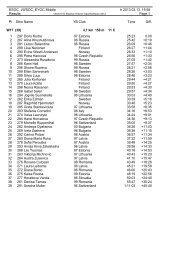
International Specification for Orienteering Maps
International Specification for Orienteering Maps
International Specification for Orienteering Maps

You also want an ePaper? Increase the reach of your titles
YUMPU automatically turns print PDFs into web optimized ePapers that Google loves.
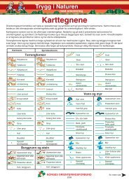
ø 0.550.70.120.120.720.300.840.42(36%)30%60%404 Rough open land with scattered treesWhere there are scattered trees in rough open land, areas of white (or green) shouldappear in the tone. Such an area may be generalised by using a regular pattern of2large white dots in the yellow screen. Areas smaller than 16 mm in the maps scaleare shown as rough open land (403). Individual trees may be added (418, 419, 420).Colour: yellow 70% (60 lines/cm), white 48.5% (14.3 lines/cm).405 Forest: easy runningTypically open runnable <strong>for</strong>est <strong>for</strong> the particular type of terrain. If no part of the <strong>for</strong>estis runnable then no white should appear on the map.Colour: white.406 Forest: slow runningAn area with dense trees (low visibility) which reduces running to ca. 60-80% ofnormal speed.Colour: green 30% (60 lines/cm).407 Undergrowth: slow runningAn area of dense undergrowth but otherwise good visibility (brambles, heather, lowbushes, and including cut branches) which reduces running to ca. 60-80% of normalspeed. This symbol may not be combined with 406 or 408.Colour: green 14.3% (11.9 lines/cm).408 Forest: difficult to runAn area with dense trees or thicket (low visibility) which reduce running to ca. 20-60%of normal speed.Colour: green 60% (60 lines/cm).409 Undergrowth: difficult to runAn area of dense undergrowth but otherwise good visibility (brambles, heather, lowbushes, and including cut branches) which reduces running to ca. 20-60% of normalspeed. This symbol may not be combined with 406 or 408.Colour: green 28.6% (23.8 lines/cm).100%YELLOWø 0.20.50.8ø 0.50.8BLACK0.12ø 0.224.5 Man-made featuresNote: dimensions arespecified in mm atthe scale of 1:15 000.All drawings are at1:7 500 <strong>for</strong> clarity only.414 Distinct cultivation boundaryThe boundary of cultivated land when not shown with other symbols (fence, wall,path, etc.) is shown with a black line. A permanent boundary between different typesof cultivated land is also shown with this symbol.Colour: black.415 Cultivated landCultivated land which is seasonally out-of-bounds due to growing crops may beshown with a black dot screen.Colour: yellow 100%, black 5% (12.5 lines/cm).416 Distinct vegetation boundaryA distinct <strong>for</strong>est edge or very distinct vegetation boundary within the <strong>for</strong>est.Colour: black.417 Indistinct vegetation boundaryIndistinct boundaries between areas of green, yellow or white are shown without aline. The edge of the area is shown only by the change in colour or dot screen.418, 419, 420 Special vegetation featuresSymbols 418, 419 and 420 can be used <strong>for</strong> special small vegetation features. The0.18definition of the symbol must be given in each case in the map legend.Colour: green.The track network provides important in<strong>for</strong>mation <strong>for</strong> the runner and the classificationmust be clearly recognisable on the map. Particularly important <strong>for</strong> the competitor isthe classification of smaller paths. Account must be taken not only of the width, butalso of how obvious the path is to the runner.Other man-made features are also important both <strong>for</strong> map reading and as controlpoints.1.5YELLOWø 0.45 0.8GREEN0.2 0.85min.0.250.41.30.6410 Vegetation: very difficult to run, impassableAn area of dense vegetation (trees or undergrowth) which is barely passable.Running reduced to ca. 0-20% of normal speed.Colour: green 100%.411 Forest runnable in one directionWhen an area of <strong>for</strong>est provides good running in one direction but less good in others,white stripes are left in the screen symbol to show the direction of good running.Colour: green, white.412 OrchardLand planted with fruit trees or bushes. The dot lines may be orientated to show thedirection of planting. If yellow coloured areas becomes dominant, a screen (75%)instead of full yellow may be used.Colour: yellow and green 25% (12.5 lines/cm).413 VineyardThe green lines may be orientated to show the direction of planting. If yellow colouredareas becomes dominant, a screen (75%) instead of full yellow may be used.Colour: yellow and green.15min. 0.30.25 3.0min. 0.50.25 3.0160.180.18501 MotorwayA road with two carriageways. The width of the symbol should be drawn to scale butnot smaller than the minimum width. The outer boundary lines may be replaced withsymbols 519, 521, 522 or 524 if a fence or wall is so close to the motorway edge that itcannot practically be shown as a separate symbol. The space between the blacklines must be filled with brown (50%). A road under construction may be shown withbroken lines.Colour: black and brown 50% (60 lines/cm).502 Major roadRoad wider than 5m. The width of the symbol should be drawn to scale but not smallerthan the minimum width. The outer boundary lines may be replaced with symbols519, 521, 522 or 524 if a fence or wall is so close to the motorway edge that it cannotpractically be shown as a separate symbol. The space between the black lines mustbe filled with brown (50%). A road under construction may be shown with brokenlines.Colour: black and brown 50% (60 lines/cm).