Urban design baseline report
Urban design baseline report
Urban design baseline report

You also want an ePaper? Increase the reach of your titles
YUMPU automatically turns print PDFs into web optimized ePapers that Google loves.
Lee-on-the-SolentClient: SEEDA191801/BAS/UD/-June 2007<strong>Urban</strong> <strong>design</strong><strong>baseline</strong> <strong>report</strong>Terence O’Rourkecreating successful environments
aseline <strong>report</strong> urban <strong>design</strong>contents1 The Masterplanning role p32 Site overview p4site plan3 <strong>Urban</strong> <strong>design</strong> analysis p6access and activitiespedestrian connectivityvehicular connectivitylandscape featurestownscape qualitybuilding heightscharacter areas4 The six parts of the p24Daedalus siteWaterfrontHangars WestHangars EastStubbington LaneSea LaneManor Way5 Summary p326 Next steps p33Terence O’Rourkecreating successful environments
1 The Masterplanning Role3As masterplanners for the Daedalus project,the role of Terence O’ Rourke and ForumHeritage Services is to develop andcommunicate an exciting yet deliverablevision for the layout, use and character ofthe Daedalus site. This will be achieved byworking closely with local communities, keystakeholders, SEEDA and other members ofthe SEEDA project team.The vision will be developed into a master plan, which willguide and co-ordinate changes across the site, ensuringthe delivery of sustainable forms of development whichrelate to and enhance their context and respond to localneeds and aspirations.To inform the master plan an important step is tounderstand the character of the site and its componentparts. Through site visits and desk based researchTerence O’ Rourke and Forum Heritage Services havetherefore undertaken an urban <strong>design</strong> analysis of the siteand its context, set out below.Associated <strong>report</strong>s cover Landscape, Heritage andSustainability.The Wardroom overlooking the sea
42 Site overviewThe Daedalus project is made up of six subsites of varying sizes and characters, locatedbetween the villages of Stubbington and Leeon-the-Solenton the Gosport Peninsula.The six sub sites:• Hangars West is located between the edge ofStubbington and the airfield within the strategic gapand contains a number of large hangars.• Hangars East is located in the middle of the strategicgap and has a large number of hangars dispersedacross it.• Waterfront lies between the seafront, the built up areaof Lee-on-the-Solent and the airfield. It contains aconcentration of buildings, including some of historicand architectural value and a <strong>design</strong>ated conservationarea.• Stubbington Lane and Sea Lane are two small subsites in the south of Stubbington.• Broom Way is located within a residential area of Leeon-the-Solent.Aerial view of the site, showing site boundaries
5Gosport RoadStubbington Lane12Broom Way453keyOwnership Boundaryboundary1. Hangars West2. Hangars East3. Seafront4. Stubbington Lane5. Sea Lane6. Broom Way1. Hangars West2. Hangars East3. Waterfront4. Stubbington Lane5. Sea Lane6. Manor WayMarine Parade6Site boundaries
63 <strong>Urban</strong> <strong>design</strong> analysisThis section seeks to capture the character, function and physical attributes of Daedalus byconsidering the site from different perspectives. Whilst interesting in themselves the primaryobjective through this process is to identify the potential of the site, and its constituent parts, andbegin to indicate <strong>design</strong> cues or avenues which might be explored in the <strong>design</strong> phase to follow.Access and activitiesThe first issue to be addressed is the site’saccessibility and connectivity, both forvehicular transport and for pedestrians.This influences the sustainability of thesite, and differing parts of it and indicatespotential in terms of development intensityand the potential for public, community andcommercial uses.Please see the <strong>report</strong> by transport consultants MVA whichis the primary resource on access and transportationmatters.• Overall the six areas have the potential to be wellconnected into the existing street network. Proximityto existing shops and services varies considerablybetween the sub sites.• The Waterfront area has the greatest potential forintegration with existing routes, as it benefits from anumber of clear access points from Marine Parade andfrom the housing area to the east. The grid like layoutof this adjacent residential area means that thereare relatively direct routes between the site, nearbycommunity facilities and the centre of Lee-on-the-Solent.• There is good access to the northern part of theHangars West area from Gosport Road. This part ofthe site is the closest to the centre of Stubbington.• Baycroft Special School and Crofton SecondarySchool are located opposite the Hangars West areaon Gosport Road and create a potential focus forcommunity or residential development in this area• Hangars West has a series of additional possibleaccess points. Of these Hammond Industrial Estateand William close offer the best links as they would beoverlooked by buildings and connect the site directlywith Stubbington Lane, leading to the centre ofStubbington.• Hangars East has possible access points from GosportRoad, Broom Way and Chark Lane but it has the leastpotential for integration with existing pedestrian routesand has the poorest access to local shops and services.Potential access to Hangars West via William Close.This street is relatively well overlooked and provides adirect connection to Stubbington Lane, leading to thecentre of Stubbington.Drake Road, to the east of the Seaplane hangarsprovides an existing, though currently non operationalaccess into the Waterfront sub site. This street leadsdirectly from Marine Parade to a key node in theWaterfront area..Manor Way is a quiet, residential street with a ruralcharacter. It leads to an existing, non-operationalentrance to the Waterfront area. This could providea good local link, but the character of the street limitsvehicular capacity.Other potential accesses into Hangars West areavailable but via poorly overlooked garage courts.These would however provide minor pedestrian/cycleroutes to Stubbington town centre.An existing but rarely used access into the Waterfrontarea from Marine Parade between the Seaplanehangars. This is the most prominent entrance and couldbecome a main pedestrian/cycle link. The slipway acrossthe road provides the site with access to the water.Existing non-operational site access to the Waterfrontarea from Nottingham Place, a quiet residential street.The entrance is overlooked by Eagle Block and theMain Gate Guardroom. It leads into a key spine street.
7Gosport RoadStubbington LaneBroom WayMarine ParadekeyOwnership BoundaryboundaryCycle pathFootpathsFootpathsBridle wayExisting operational accessExisting operational accessExisting non-operational accessExisting non-operational accessPotential accessPotential accessCentres of community life lifeAccess and activities
8Gosport RoadStubbington LaneBroom WayMarine ParadekeykeyOwnership BoundaryOwnershipOwnershipboundaryboundaryStubbington town centreStubbingtonStubbingtontowntowncentrecentreLee-on-the-Solent town centreLee-on-SolentLee-on-Solenttowntowncentrecentre~800m~800m(10min(10minwalk)walk)fromfromtowntowncentrecentretowardstowardssitesite800m (10min walk) from Stubbingtontown centre towards site~800m~800m(10min(10minwalk)walk)fromfromtowntowncentrecentretowardstowardssitesite800m (10min walk) from Lee-on-the-Solent town centre towards siteExistingExistingandandpotentialpotentialsitesiteaccessesaccessesExisting and potential site accessPedestrian connectivity
9Pedestrian connectivityThe extent to which six sub sites can be viewedas either urban, suburban or rural is partlybased on the accessibility of key facilities byfoot.An attractive parade of shops in Lee-on-the-Solent,within walking distance of the Waterfront area.Local shop in Lee-on-the-Solent.A walkable neighbourhood is broadly considered to be onewhere good bus services are available within 5 minuteswalk (400m) and convenience shopping and communityfacilities are within 10 minutes walk.Bikes in the centre of Stubbington. The flatterrain encourages cycling.Shops in Stubbington, a busy local centre.The plan opposite highlights the walkability of the siteby showing the routes to and from the centres ofStubbington and Lee-on-the-Solent. This highlights thegood accessibility of the Waterfront area from the centreof Lee-on-the-Solent. Hangars West is also walkablefrom the centre of Stubbington. Hangars East is not withinreasonable walking distance of shopping or communityfacilities.The beach becomes busy in the summer,providing an opportunity to draw people intothe seafront part of the site.Baycroft Special School on Gosport Roadopposite Hangars West. The two schools herecould bring activity to the northern part ofthe site.
11Gosport RoadStubbington LaneBroom WayMarine ParadekeyOwnershipBoundaryMost most connectedleast connectedLeast connectedVehicular connectivity
12Landscape featuresIn broad terms the site’s key landscape characteristics are:• The relatively flat topography• The openness of the landscape across and around theairfield• The limited opportunity for views of the south and westof the airfield• The lack of vegetation to screen urban edges• Limited trees within Waterfront areaFurther detailed assessment would be required if andwhen an environmental impact assessment were to beproduced to support a planning application.View towards Daedalus across the Alver Valley which forms part of theStrategic Gap. The countryside includes wooded areas, arable fields,paddocks and a golf courseLandscape features within the Alver Valley include fences, ditches, gappyhedgerows and scrubby woodlandPlease see the accompanying landscape <strong>report</strong> for furtheranalysis.View down a narrow country lane in the Alver ValleyFlat and exposed field in north east corner of Hangars East
15Townscape qualityQuality here is defined principally in terms of thematurity of the soft landscape, cohesiveness,legibility and clarity of street layouts,distinctiveness of architectural style and form,attention to architectural detail and use ofnatural materials. Areas which display thesecharacteristics are considered to be of highquality. Areas where such characteristics arelacking are considered to be of average or lowquality.• Within the immediate vicinity of Daedalus, theresidential area to the east of the Waterfront area,together with the centre of Lee-on-the-Solent,have the greatest townscape quality. This area ischaracterised by a clear perimeter block layout withsignificant mature vegetation and attractive greenspaces and a higher density of development focusedon the High Street and seafront. The layout providesviews towards the sea and a variety of clear local routes.Some of the positive characteristics of this area willbe applicable to the development of Daedalus andintegration between the site and this area will be crucial.• Despite its generally strong townscape quality, thenorthern stretch of the centre of Lee-on-the-Solentsuffers from a poor quality public realm. It will beimportant for development at Daedalus to reinforcethis existing centre rather than competing with it.• The northern part of the Waterfront area currentlyhas low townscape quality, with poorly defined routesand a discordant mix of buildings. It will therefore benecessary to establish a more coherent townscapestructure in this area.• The seafront is an important part of the publicrealm, offering open space, long views, recreationalopportunities and an important route towards thecentres of Lee-on-the-Solent and Stubbington.The development of Daedalus should aim to maximiseand protect these benefits.• The majority of positive buildings in the vicinity arelocated within Lee-on-the-Solent and the Waterfrontarea. These buildings are of attractive proportions,relate successfully to streets and spaces, andbenefit from careful architectural detailing and goodquality materials. Industrial buildings in other partsof the Daedalus site are simpler and less detailed.Nevertheless they have a certain functional characterand those in prominent positions form significant locallandmarks.Saint Faith’s Church – a local landmarkPoor quality temporary modular buildings in the northernpart of the Waterfront areaSeafront housing on Marine Parade.Café on Marine Parade
16Building heightsThe majority of buildings in the vicinity of the site are twostoreyalthough there are a number of three andfour storey buildings on Marine Parade and in the centreof Lee-on-the-Solent.Within the site the industrial buildings tend to be onevery tall storey, rising to around 10m. The domestic andinstitutional buildings within the Waterfront area aremostly two or three generous storeys.Two storey housing – former married quarters adjacent to the siteBuildings on Marine Parade rise to four storeysSingle storey hangars within the site rise to approximately 10m.Swann Hangar was built in the 1920s and addresses the airfield in thenorthern part of the Waterfront area.
17Gosport RoadStubbington LaneBroom WaykeyNon-domestic scale:Marine Parade>10m>10m
18Character areasThe areas in and around the site differconsiderably in their appearance and function.The distinctive characters can be summarisedas follows:AirfieldThe three runways of the former naval air base producea vast, open triangle whose safe functioning demandedclear and legible operational areas with good accessand security. Beyond the triangle support services andfacilities were contained adjacent to the perimeter roadoften within large hangars.Although the buildings in this area are bulky their simplecladding and lack of fenestration gives them a barn likeappearance, limiting their impact in the strategic gap.Their distribution appears random helping to support thegeneral rural character.The current uses of the buildings in this area is generallyunintensive, meaning that car parking and vehicularmovements are limited, maintaining tranquillity in thestrategic gap.Village centreAttractive shopping parade in the centre of Lee-on-the-SolentStubbington and Lee-on-the-Solent village centres formthe focus of community life in each settlement. Bothare mixed use and easily accessible to the surroundingresident community as well as to passing trade. Bothprovide convenience shopping and community facilitiesand services. Lee-on-the-Solent centre has thepotential to become a more vibrant seafront destination.
19Gosport RoadStubbington LaneBroom WayInstitutionAirfieldVillage CentreBeachsideMarine ParadeMarine paradeSuburban gridSeaplanesCountry laneOpen countryDisconnected suburbiaBuildingsCharacter areas
20SeaplaneThe former focus of seaplane operations on the site isthis group of five large hangars parts of which date fromthe First World War. The hangars are arranged arounda cruciform, shared space, which each building helpsenclose, the group has an uncompromising simplicity andlegibility both in plan form and building <strong>design</strong>.Eagle BlockInstitutionThis character area is entirely within the Daedalus site andcomprises most of the early 20th century staff quartersand support buildings. In large part this corresponds withthe <strong>design</strong>ated conservation area, apart from the formerseaplane hangars adjoining the slipway.The area consists of groups of buildings, areas ofhardstanding and lawn areas. Although there are gapsin the streetscape, most of the buildings follow a clear,geometric grid layout.The buildings are generally of considerable size, risingto three storeys with generous floor to ceiling heights.They are typically red brick with pitched, tiled roofs andboundaries tend to be formed by red brick walls.WWI Seaplane hangarsDepth in the facades created by entrances andfenestration adds to their substantial appearance.Windows are generally vertically proportioned andarranged in a clear, repetitive rhythm, creating a formalcharacter.
21Marine ParadeMarine Parade is lined by mainly residential buildingsoverlooking the seafront and dating from the 1880s,1930s and more recent decades. The piecemeal natureof development has resulted in a variety of buildingtypes. Most are two and three stories, with some blocksof flats of four and five storeys. Building materials includered brick and pale renders. Roof forms are also varied,including gabbled, hipped, and flat roofs. A numberof buildings have balconies, contributing to a seasidecharacter.Well maintained entrance to a property in the Beachside character area,benefiting from mature trees and extensive planting.Marine Parade is a very straight street and the propertiesfollow a consistent building line. Front boundaries tend tobe marked by low walls, hedges or fences.BeachsideThis small but distinctive character area is centredaround Sea Lane which provides direct access to thebeachfront and its parking. Whilst the architecture isgenerally disappointingly suburban the character of sanddunes, pine trees and large plots creates an attractiveinformality.View east down Marine ParadeAerial view of the seafront
22Disconnected suburbiaIn contrast to earlier phases, late 20th century housing,both in Lee-on-the-Solent and Stubbington, eschewedthe accessible grid in favour of layouts <strong>design</strong>ed tomanage vehicle movements, especially through traffic.These areas are almost exclusively residential and includenewly-built Cherque Farm.A characterful and prominent Victorian property on a corner plot.Suburban gridThis area emerged from the earliest plans for Lee-onthe-Solent,drawn up in the 1880s. The plan created agrid of streets reaching from the village centre to the edgeof the site with generous plots for housing providing forgenteel living close to the seafront. A number of notablehouses were built at this time, but much of the area wasdeveloped in the 1920s and 30s.The properties are a range of two-storey detached andsemi-detached houses, most of which are brick built withpitched roofs. The more characterful properties benefitfrom careful detail in the brickwork and fenestration.Residential cul-de-sac in the suburban area to the east of DaedalusProperties are set back from the street, with boundariesformed by brick walls and hedges. Planting within frontgardens and street trees create a green and establishedcharacter.
23Open countryThis significant area of open land to the north and east ofDaedalus in the Alver Valley encompasses open fields with somewooded areas and occasional agricultural, recreational andresidential buildings. Uses include paddocks and a private golfcourse.Paddock in the countryside to the east of DaedalusView down Manor Way, which has the character of a country laneCountry laneThis secluded meandering route is a remnant of anhistoric and rustic lane, which has subsequently becomesurrounded by suburbia. Manor Way remains a narrowroute, enclosed by hedges and has stretches with nopavements. Its distinctive and charming characterdistinguish it from its more planned neighbours.View down Shoot Lane
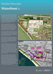
244 The six parts of the Daedalus siteWaterfront(25.8 hectares)The Waterfront area is the most developedpart of Daedalus and overlooks the Solent.In broad terms it comprises a combination ofbrick faced former offices or domestic buildingsalongside large-scale industrial/warehousingbuildings. Part of the area is a conservationarea in which three buildings are listed andthree are recommended for listing.The Wardroom buildingStrengths• The Waterfront area has the strongest character andgreatest interest, with a variety of historic landmarkbuildings and important spaces.• A key focus is the group of World War One Seaplanehangars, the space between them and the slipway.The three hangars closest to the seafront have beenrecommended for listing. The hangars occupy aprominent position on the seafront while the largehard surface space has a functional character and thecapacity to be used for a wide variety of activities.• The grade II listed Wardroom is perhaps the mostrecognisable building on the site and views towardsit from the centre of Lee-on-the-Solent make itGrade II Listed Dining Rooms and Cookhousean important landmark for Daedalus. Forming thesetting to this building and the adjacent grade II listedWestcliffe house is a large lawn which provides a raregreen space within the Waterfront area.• Further into the site the Barrack Blocks and grade IIlisted Dining Rooms and Cookhouse form a formal,symmetrical group of buildings, fronting onto a clearlydefined square.• The grid-like arrangement of routes results in anumber of vistas towards the sea from different partsof the site. Very little of the site has sea frontage butthe clear views and routes between the waterfront siteand the sea are an important asset.WWI hangars (recommended for listing)Vista towards the sea
25Marine ParadekeyOwnership BoundaryOwnership boundaryFocal spaceFocal spacePrincipal frontagePrincipal frontageLandmark buildingsKey featuresSea viewsSea viewsInternal viewsInternal viewsExisting operational site accessExisting operational site accessNodeKey junctionWaterfront character strengths
OwnersInstituti26keyIndustrResidenotesA 26.07.07 adjuMarine ParadestatusDraftclient / projectSEEDADaedalusdrawing titleSeafront: buildinscaleNTSkeyOwnership boundaryOwnership BoundaryInstitutional/commercialInstitutional / commercialIndustrialIndustrialDomesticResidentialWaterfront building typesdateApril 2007drawing no.191801/2/001/SBased upon the 200permission of the OStationary Office ©License No. AL1000TerenceTown planning • UrbLandscape architecEverdene House DTelephone 01202 4Email maildesk@toDo not scale from thTerence O’Rourk
27Building types• Within the Waterfront area most of the buildings werebuilt for either institutional or industrial use.• The institutional buildings are mainly located in theeastern part of the Waterfront area, closest to theexisting residential area.• The functional, industrial buildings are located closerto the airfield or seafront.• There are few residential buildings within the Waterfrontarea but the grade II listed Westcliffe House and itslodge (Church Cottage) are of particular character andinterest.Residential building - Westcliffe HouseIndustrial - Seaplane hangarDetail of Westcliffe HouseInstitutional building - Eagle block
28Hangars West(14.3 hectares)Hangars WestAerial view of Hangars West and adjacent housingStubbington LaneHangars WestkeyOwnership BoundaryOwnership boundaryPrincipal frontagePrincipal frontageIndustrialIndustrialInstitutional/commercial / commercialKey Landmark featureHardstandingImportant green space spaceTree Tree/hedge / hedge screen screenPublic Pedestrian footpath route off-streetkeyOwnership boundaryPrincipal frontageOther buildingIndustrialInstitutional/commercialExisting non-operational site accesssite accessKey featureHardstandingImportant green spaceTree/hedge screenPublic footpath off streetExisting non-operational site accessKey viewsHangars West essentially comprises three linked trianglesof land formed by the new airfield boundary and a serratededge to Stubbington.• Hangars West consists of an irregularly shaped areaof flat grassland and hard standing containing sixlarge hangar buildings.• Located within the strategic gap at the edge of thebuilt up area of Stubbington. There is little vegetationto soften the transition from built development toopen land. The existing stepped edge of the built uparea creates an abrupt end to the strategic gap.• The most prominent hangar is located close toGosport Road, opposite the existing school buildings.The proximity of Baycroft Special School and CroftonSecondary School creates the potential for acommunity focus in the northern part of the site.Key viewsKey viewsnotesA 30.05.07 updated further to feedback SWDB 26.07.07 updated further to feedback SWD• Back gardens of houses line the site boundary andtheir privacy and security will need to be protected.statusDraftclient / projectSEEDADaedalusdrawing titleHangars West,Stubbington Lane & Sea LaneHangars WestscaleNTSdateApril 2007drawing no.drawn bySWDchecked byRSrevision no.
keynotesstatusclient / projectdrawing titlescaledatedrawing no.drawn bychecked byrevision no.Based upon the 2005 Ordnance Survey landline data with thepermission of the Ordnance Survey on behalf of her Majesty'sStationary Office © Crown copyright. Terence O'Rourke Ltd.License No. AL100017826.Town planning • <strong>Urban</strong> <strong>design</strong> • Environmental consultancyLandscape architecture • Architecture • Graphic <strong>design</strong>Everdene House Deansleigh Road Bournemouth BH7 7DUTelephone 01202 421142 Facsimile 01202 430055Email maildesk@torltd.co.ukDo not scale from this drawing29dHangars East(40.3 hectares)Gosport RoadBroom WayHangars East is defined by the new airfield boundary andstrategic roads to Stubbington and Lee-on-the-Solent.Aerial view of Hangars EastBroom Way• Hangars East is located within the strategic gap and isthe most exposed of the sub sites.Hangars Eastgars East• The area consists of, flat grassland within whichfourteen hangar buildings are set. These are linked andserviced by significant areas of hard standing.• The hangars are dispersed apparently quite randomlyacross the area. Their appearance as large, simplestructures scattered in the open grassland gives thisarea a distinctive character while the hangar’s curvedforms and muted colours fit well into the green setting.• This sub site relates poorly to existing built up areas,with little opportunity for integration.keyOwnership boundary BoundaryPrincipal frontageIndustrial buildingInstitutional Institution/commercial / commercialHardstandingKey Landmark featureTrees/hedges/ hedgesDraftSEEDADaedalusOwnership boundaryPrincipal frontageIndustrial buildingInstitution/commercialOther buildingHardstandingKey featureTrees/hedgesExisting operational accessExisting non-operational accessPublic footpath off streetBacks to public realmKey viewsA 26.07.07 adjustments to buildings and roads SWDExisting operational accessExisting operational accessExisting non-operational access accessHangars EastNTSApril 2007191801/3/001/HESWDRSAPublic footpath off streetBacks onto public public realm realmKey viewsHangars EastTerence O’RourkeTerence O’Rourke Ltd
datApdra19BasperStaLiceEveTeleEm© T30Hangars WestStubbington Lane(0.4 hectares)This is a small sub site at the south of Stubbington,adjacent to existing housing with frontages on toStubbington Lane and a narrow country lane. It hassignificant vegetation around the boundaries and iscurrently used to graze horses.Sea Lane(0.25 hectares)This is a small sub site at the south of Stubbington,adjacent to existing housing with frontages on toStubbington Lane and Sea Lane. It has significantvegetation around the boundaries and is currently used tograze horses.Stubbington LaneBroom Way(1.6 hectares)This is a roughly square area, which is currently grassland,relatively close to the centre of Lee-on-the-Solent. Thesub site fronts onto Manor Way and the remaining threeboundaries are lined by the back gardens of existinghouses, whose privacy and security should be protected inany development.keyThe Stubbington Lane sub site is screened by mature vegetationStubbington Lane to the north and Sea Lane to the south. The sub sitesare located to the west of the airfield.The Manor Way sub site, backed onto by existing housing..notA 3Marine ParadeBroom WaystatDrclieSEDadraHaStuscaNTThe sub site is located on the main route into Lee-on-the-Solent andopposite a tennis club.TTowLanDoMarine
325 SummaryThis summary highlights the site’s context,character and potential for development.Hangars West• on the outskirts of Stubbington’s residential area• has the potential to accommodate further housingaccessed via residential streets and/ or employmentuses accessed via Hammond Industrial Estate.• a softer edge to the strategic gap should also becreated together with any development in this area.• The northern part is most accessible, relates tothe schools and is walkable from the centre ofStubbington. It could form a focus for community orrecreational uses.Hangars East• has an exposed, rural character.• least accessible by foot and bike and the leastconnected to existing built up areas.• least suited to residential development• potential to accommodate employment andrecreational uses which preserve the character ofopen landscape containing scattered buildings.Waterfront• greatest development potential given proximity tothe centre of Lee-on-the-Solent, good connectivity,important historic buildings and open spaces, accessto the sea and urban character.• should be developed on an urban grid, where buildingblocks contain routes and spaces.• suitable for relatively intensive development,incorporating a mixture of employment, community,recreational and residential uses.Stubbington Lane and Sea Lane• small, secluded sub sites with potential for residentialdevelopment but relatively poor access to shops andother facilitiesManor Way• reasonably accessible from the centre of Lee-onthe-Solent.Potential for residential development andamenity space, screened from existing housing.
6 Next steps33This document will continue to evolve aswell as be updated to reflect our developingunderstanding of the site. It is envisaged thatthe content of this document, in whole orpart, will form a part of the introduction to thefinal master plan document (along with theassociated <strong>report</strong>s).The next stage of the project requires a clear vision to beidentified for the site and its constituent parts. This workwill be collected into a summary document of its own.SurveysFurther technical information is required to help establishopportunities and constraints for development. We wouldrecommend surveys are commissioned with regard to:• ecology• trees• contamination• buildings with potential for re-use• topography
Everdene House Deansleigh RoadBournemouth BH7 7DUT: 01202 421142 F: 01202 430055E: maildesk@torltd.co.uk W: www.torltd.co.ukTerence O’Rourkecreating successful environments