Daedalus masterplan - Solent Enterprise Zone
Daedalus masterplan - Solent Enterprise Zone
Daedalus masterplan - Solent Enterprise Zone

Create successful ePaper yourself
Turn your PDF publications into a flip-book with our unique Google optimized e-Paper software.
DAEDALUS1CONTENTSINTRODUCTION 2HANGARS EAST & HANGARS WEST 38Location 2Document structure 2CONTEXT 4The site 4Historic context 4Planning context 4Constraints & opportunities 6Design concept 38Design principles 38The <strong>masterplan</strong> 39Access 40Mix of uses 40Open space and landscape 42Character Areas 44SUSTAINABILITY 48DESIGN EVOLUTION 10Sustainability strategy 50Vision 10Key principles 10Consultation 10Overall <strong>masterplan</strong> 11Transport 12CONCLUSION 53THE WATERFRONT 14Design concept 14Design principles 14The <strong>masterplan</strong> 15Access 16Mix of uses 17Open space and landscape 18Character Areas 20Implementation and phasing 36REF: 2780_R002_Masterplan Report - 01/10© LDA Design Consulting LLP. Quality Assured to BS EN ISO 9001 : 2000. No dimensions are to be scaled from the drawings in this report. All dimensions are to be checked on site. Area measurements for indicative purposes only.Based upon Ordnance Survey map with the permission of the controller of H.M.S.O. © Crown copyright Reproduced under SEEDA License No. 100029140 (2009). All aerial photography is under copyright © Google
DAEDALUS3SITE LOCATION
4 DAEDALUS2.0CONTEXTTo ensure that the proposalsHangars West – 14.39 HectaresAt the outbreak of World War II, and as aFurthermore, PPS1 encourages theemerge as a response to the physical, socialHangars West comprises three linkedresult of the transfer of Fleet Air Arm tofacilitation and promotion of sustainableand economic context of the site, andtriangles of land formed by the serratedAdmiralty Control, the facility becameand inclusive patterns of urbanbring benefits to the local community, anedge of Stubbington, and lies on the westHMS <strong>Daedalus</strong>.development, which supports existinganalysis has been undertaken of <strong>Daedalus</strong>side of the airfield. There is currently ancommunities and contributes to theand the surrounding area. This includesunused access point on Gosport Road. It isDuring World War II the site became a keycreation of safe, sustainable, liveable andthe history of the area, its present character,a large, flat area bordering the remainingaviation base with an expanding camp andmixed communities with good access totransport links and facilities. A range ofactive runway, with various hangars andairfield to the north and north east, andjobs and key services for all members of theconsiderations for the development of thetaxi ways. The building extends to somewas a crucial base to air sorties. The sitecommunity.site concludes this section.7,140 sqm.suffered two air raids because of its militarysignificance.<strong>Daedalus</strong> is previously developed landand SEEDA considers that this siteTHE SITEHISTORIC CONTEXT<strong>Daedalus</strong> continued in military use afterprovides a significant opportunity to1945, although on a smaller scale andundertake holistic development whichfocusing on technical training, particularlywill provide investment, create jobs and<strong>Daedalus</strong> can be divided into three keyThe site was open farmland until the 1880s,helicopter and hovercraft testing. HMSencourage commercial prospects. Inareas all of which have very differentwhen there was an attempt to develop<strong>Daedalus</strong> closed in 1996, the MoD declaredparticular, it is envisaged that <strong>Daedalus</strong>characters and uses.a seaside health resort of Lee-on-the-it surplus to requirements in 2004. It waswill strengthen the area’s position as aThe Waterfront – 25.82 Hectares<strong>Solent</strong>. Central to the development wasthe seafront itself and Marine Parade Eastsubsequently acquired by SEEDA and theMaritime and Coastguard Agency (MCA)centre for employment, which may includeaccommodation for marine and aviationThe Waterfront lies between the seafront,and West, along with parkland (West Cliffin 2006.industries.the built up area of Lee-on-the-<strong>Solent</strong>Park and East Cliff Park), promenades andand the airfield. and falls within Gosportpier. A new ‘village centre’ soon appeared,As part of the interim letting strategyDraft PPS4 (Planning for SustainableBorough Council’s administrativewith shops along Pier Street and the hotel.many occupiers, including small andEconomic Development) states thatboundary. This area is the most developedOn the <strong>Daedalus</strong> site a few buildings ofmedium sized businesses, make use of theeconomic growth generates wealth andpart of <strong>Daedalus</strong> and has direct access toparticular interest were developed, mostformer hangars and military buildings.raises living standards. In particular,the <strong>Solent</strong> via the slipway. It comprises anotably Westcliffe House and its estate,It is hoped that the majority of these usesDraft PSS4 notes that productivity andcombination of brick-face former officesNorbury House, Keith Cottages andwill continue to use the site and theiremployment influence wider economicand domestic buildings alongside large-Wykeham Hall.requirements are incorporated into theseobjectives such as regeneration andscale industrial/warehousing buildings.proposals. To the north, the MCA sea andthe provision of new housing whichSome of the buildings are of historic andIn 1917 the site was requisitioned to provideair rescue operate and utilise the runway,contribute to quality of life. Developmentarchitectural value. Part of this area is aa training school for seaplane pilots andand the Driving Standards Agency have aat <strong>Daedalus</strong> is expected to have a positivedesignated Conservation Area, in whichpermanent Admiralty Designed Hangars,test centre.impact in terms of sustainable economicthree buildings are listed. The total builtbuildings and a slipway were developed.development for the surrounding areasfloorspace of the Waterfront extends tosome 67,640 sqm.By the end of the war the site had a staff ofnearly 500, providing training for almost100 pupils.PLANNING CONTEXTwithin Fareham and Gosport Boroughs.Regional policyThe two other key areas at <strong>Daedalus</strong>,Hangars East and Hangars West, fall withinAfter World War 1, the site became theNational policyRegional Planning Guidance 9 (RPG9March 2001) provides a regional frameworkFareham Borough Council’s jurisdiction:base for the newly formed Fleet Air Arm,National planning policy seeks to promotefor the longer term future of the South East.Hangars East – 40.45 Hectaresand growth continued into the 1930swhen the site became Coastal Commandthe more efficient use of land throughhigher density, mixed use developmentThis will shortly be replaced by the SouthEast Plan. Key topics covered in the Plan areHangars East is located on the eastHeadquarters. A number of importantand the use of suitably located previouslyhousing, transport, employment and theside of the airfield and is accessed frombuildings appeared on the site during thisdeveloped land and buildings (Planningenvironment.Broom Way. This area consists of areasperiod including Eagle Block, the WardPolicy Statement 1 Delivering Sustainableof hardstanding with groups of looselyRoom, the Barrack Blocks and Dining RoomDevelopment – PPS1). In particular,<strong>Daedalus</strong> has been identified by theclustered hangars adjacent to the airfieldand Cookhouse.the Government has set targets forPartnership for Urban South Hampshireand a red brick building. There is somedevelopment on previously developed land(PUSH) as an area of strategic importance9,680 sqm of built space in this area.to bring vacant and under-used sites andfor employment purposes.buildings back into beneficial use.
DAEDALUS7WATERFRONT HERITAGE ELEMENTSSite boundaryConservation AreaListed building and curtilageBuilding recommended forlistingExisting treeWATERFRONT SITE ANALYSISSite boundaryKey heritage building withinConservation AreaKey heritage building outsideConservation AreaHeritage open space - pavedHeritage open space - greenExisting treePotential site accessLinear viewOpen viewExposed airfield edgeResidential edge
8 DAEDALUSAerial view of the airfieldHangars EastSocio-economicsAir QualityNoiseWater Resources and Flood RiskRegeneration of the <strong>Daedalus</strong> site hasDevelopment of the site is likely to resultConstruction noise could causeDuring construction best practicethe potential to provide increased localin impacts to local air quality during thedisturbance to nearby residents andconstruction methods will need to beemployment opportunities which willconstruction phase and potentially oncewildlife. Good construction practiceemployed in accordance with a CEMP toallow greater accessibility to local jobs,construction is complete. Constructionthrough the implementation of bestavoid contamination of the <strong>Solent</strong> andreduce unemployment and improve skills.phase impacts should be mitigated by thepractice mitigation measures in a CEMPRiver Alver.adoption of a Construction Environmentalshould be followed to minimise noiseProviding opportunities for live-work-playManagement Plan (CEMP) requiringdisturbance.With regard to flood risk, the <strong>Daedalus</strong> sitein one area will minimise the need to travel.the adoption of best practice methodsfalls within the Environment Agency’s lowThe provision of a mix of uses will help toto minimise impacts from constructionDetailed assessments to determine therisk flood zone (Flood <strong>Zone</strong> 1). However,create a vibrant and diverse community,dust and construction plant and vehiclelikely noise impacts to sensitive receptorsfull flood risk assessments will need to bethat is active beyond the working day andemissions. Working hours must be agreedfrom operational activities shouldcarried out at the project level to supporttherefore feels safe and with a sense ofwith the relevant local authority andbe undertaken at the project level toeach planning application. Poor siteplace. This is likely to reduce crime andconsider potential impact on residents’determine suitable mitigation measures.drainage has the potential to cause floodinghardship in the boroughs and also improveamenity.To ensure a suitable internal noiseon site or elsewhere so future developmentsaccessibility to health, education, leisureenvironment in new residential units, PPGshould incorporate appropriate Sustainableand cultural facilities.There are currently no Air Quality24 assessments should be undertaken toDrainage Systems (SUDS) to achieveManagement Areas (AQMAs) in theenable acoustic ventilation requirements toappropriate run-off rates.The inclusion of private and affordableborough where national objectives forbe determined.housing will assist GBC and FBC in meetingnitrogen dioxide (NO2) or fine particulatesResidential and commercial developmentthe targets set by regional government(PM10) are exceeded. However, forNatural England should be consulted on theon site will place additional pressure onand help to ensure that everyone hasoperational phase impacts, detailed airpotential for noise impacts on the <strong>Solent</strong>the mains water supply and foul drainagethe opportunity to live in a high quality,quality dispersion modelling should beand Southampton Water SPA and Ramsarsystem. Further capacity assessment willsustainably constructed and affordablecarried out to determine the potentialsite and determine necessary mitigationneed to be undertaken in consultationhome.impact on local air quality from trafficmeasures.with Southern Water and the relevant localRecreation and Leisureflows and commercial activities. Odourassessment and potentially dispersionGround Conditionsauthority to determine the likely impactof development and potential mitigation.New residents inhabiting the <strong>Daedalus</strong>modelling should also be carried outThe strategic assessment has shown that itTo minimise impact, water efficiencysite from future residential developmentfor relevant commercial developments,is likely that contamination is present onmeasures should be incorporated into allproposals would place additional pressureincluding waste facilities, to determinesite. Best practice construction methodsdevelopments.on the existing public open space(both natural and amenity), children’srequired mitigation/abatement measures tobe incorporated.will need to be employed during grounddisturbance, in accordance with a CEMP toWasteplay areas, sports facilities and otheravoid mobilisation of contamination andFurther capacity studies and consultationrecreational facilities. Opportunities toNatural England should be consulted onremove risk to workers.will be required at the project level toincrease provision of and/or enhancethe potential for air quality impacts ondetermine how best to minimise andspaces for leisure and recreation shouldthe <strong>Solent</strong> and Southampton Water SPAFurther intrusive surveys andsort waste for recycling and disposalbe incorporated in future developmentand Ramsar site and determine necessaryassessments will need to be completedand to determine the wastewaterproposals after further capacity studies andmitigation measures.at the project level to fully characterisestrategy. Potential solutions could be theconsultation with the appropriate localthe contamination and identify source-incorporation of an on-site waste facility.authority. Mitigation/enhancement couldpathway-receptor relationships so that ainclude the creation of a military historyremediation strategy can be formulatedmuseum.to render individual sites suitable for usefor their intended purpose. The scope ofAn AA will be required to determine theintrusive assessments and remediationpotential disturbance impact on the <strong>Solent</strong>strategies will need to be agreed withand Southampton Water SPA and Ramsarthe relevant local authority and thesite from recreation and to determineEnvironment Agency.suitable mitigation. Mitigation may includea contribution to the proposed Alver ValleyPark and the provision of informationboards along the <strong>Solent</strong> Way.
DAEDALUS9hangars westairfi eldhangars east200mHANGARS EAST AND WEST SITE ANALYSISSite boundaryRetained buildingRunwayStrategic gapExisting treesPotential site accessLinear viewOpen viewExposed airfield edgeResidential edge
10 DAEDALUS3.0DESIGN EVOLUTIONVISION•To ensure a fully accessible sitePhases of consultationPhase 4 – This phase of consultation relatesintegrated into the existingSEEDA and the project team are committedto the promotion of the emerging Visionarytransport networkto maintaining this high level ofFramework. A second newsletter wasRedevelopment of the Waterfrontengagement with local residents and keydistributed to over 20,000 local residents inpresents an opportunity to embrace the•The retention of buildings ofstakeholders, and will continue to updateNovember 2008.concept of live-work-play, with a varietyhistoric interest and characterand consult as the project progresses.of employment, leisure, commercial andwherever possible with new usesThere have been five specific phases ofA two day exhibition was held on 5 andresidential uses within walking distance ofsought for themconsultation associated with the emerging6 December 2008 at the Lee Methodisteach other.plans for development at <strong>Daedalus</strong>.Church Hall with approximately 750•To maintain access to water via thepeople attending. Attendees had theThe vision for <strong>Daedalus</strong> is to transformslipway for potential recreationalPhase 1 – In spring 2007, the <strong>Daedalus</strong>opportunity to speak to members of thethis previously gated military facilityuses, marine industries and to thewebsite www. daedalus-seeda.co.uk – andProject Team as well as complete Commentinto a thriving location for the benefitpotential marinaan e-alert system was launched. ThisForms.of the whole region as well as the localresource provides regularly updatedcommunity, creating economic growth,•To ensure the long-term future ofinformation about the project and theFor those unable to attend the exhibition,a variety of employment and trainingthe airfield through the co-locationemerging development proposals.the boards were available to view on theopportunities and additional local servicesof a range of aviation-relatedwebsite as well as a summary board beingand facilities. Redevelopment will bring ancompaniesIn May 2007, a baseline survey comprisingdisplayed in four local libraries and bothunder-used and partly derelict site back intoa short questionnaire was sent to 20,000council offices until the end of Januaryproductive use whilst being sensitive to its•To meet the highest standardslocal households. This was supported by a2009. Full details on the feedback andhistoric land use, the Listed Buildings andof sustainable construction andnumber of street and door-to-door surveysconclusions are detailed in Phase 4the designated Conservation Area.designas well as being available for people toReport (Groundwork <strong>Solent</strong>, 2009).complete on the website.Full details about all events and theTo ensure the delivery of a comprehensive•To create a permeable and legibleconclusions from each phase are availabledevelopment that is robustly tested indevelopment with clear routes intoPhase 2 – Five key themes emerged fromon the <strong>Daedalus</strong> website.terms of transport and environmentaland through the sitethe first phase – employment; heritageimpacts, it is necessary to consider the siteand building design; leisure, tourismTo date, the local community andas a whole, rather than GBC and FBC’s areas•To provide a mixed-useand community facilities; green spacesstakeholders have shown a keen interestindependently. As such, a <strong>masterplan</strong> hasdevelopment which creates aand the environment; and transport andin future plans for the site with significantbeen developed for the whole of <strong>Daedalus</strong>.vibrant and busy place in which toaccess. A number of residents and strategicnumbers participating in the variouswork, live and spend leisure timestakeholders were invited to attendevents. A variety of views regarding howKEY PRINCIPLES•To enhance the setting of theworkshops on each of these themes. Thiswas followed at the end of July 2007 bythe site should be developed have beenexpressed with the following consistentListed Buildings (The Wardroom,a Drop-In Event which some 500 peoplethemes:Westcliffe House, Dining roomsattended.•To create a vibrant place with a mixand Cookhouse) on site.•Provision of employmentof uses that is integrated with Lee-Phase 3 – In November 2007, Issue 1 of theopportunities for local peopleon-the-<strong>Solent</strong> and complementsand supports the regeneration ofCONSULTATION<strong>Daedalus</strong> newsletter was distributed to over20,000 residents. Approximately 900 people•Improvements to be made to thelocal highway networkthe existing local centreviewed and commented on five master•Provision made for green, openplan concepts which were displayed overspace•To ensure that any newA Consultation Strategy was producedtwo days at the Exhibition in December•Preservation of the heritage of thedevelopment enables the site toin March 2007, which outlined SEEDA’s2007. For those unable to attend, the panelssite.benefit from its direct links to thestrategy to ensure that all stakeholderswere available to view on the website and awater and the slipwayare engaged with and consulted aboutsummary displayed at the libraries in Lee-Phase 5 - The process of finalising theemerging proposals as the projecton-the-<strong>Solent</strong>, Stubbington, Fareham and<strong>masterplan</strong> taken a collaborative approach,•A new through-route providingprogresses. This document identified howGosport.with monthly workshops held betweenaccess to the site from the eastthree key groups (strategic stakeholders,the project team, GBC, FBC and othervia Broom Way and the west viabusinesses and community) would bestakeholders such as Hampshire CountyMarine Paradetargeted.Council as appropriate.
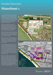
DAEDALUS11hangars westairfi eldhangars eastwaterfront250mOVERALL MASTERPLAN
12 DAEDALUSMixing uses can reduce the need to travel and create more dynamic neighborhoodsEnsuring residences and employment areas areeasily accessible by sustainable modes of transportProviding a range of employment opportunities tomeet local needsTRANSPORTReducing the need to travel<strong>Daedalus</strong>’ close proximity to Lee onThe public transport strategy is basedOne of the main reasons for high levels of<strong>Solent</strong> and Stubbington lends itself to thearound the need to significantly improveout-commuting is lack of available jobs inmaximisation of pedestrian and cyclebus accessibility to <strong>Daedalus</strong> and to linkThe emerging transport strategy isappropriate business sectors. Creation ofconnections to these communities.the site with potential workers for theunderpinned by a comprehensive set oftraffic data collected at significant locationsthe right jobs at <strong>Daedalus</strong> will give Gosportresidents greater opportunities to workTravel Planemployment uses. It will also providestrong public transport connections for thesurrounding the site.locally, contributing to a reduction in out-A comprehensive Framework Travelresidents of the Waterfront and the Lee-on-commuting.Plan for the site has been developed inthe-<strong>Solent</strong> to key transport interchanges inRedevelopment at <strong>Daedalus</strong> presents aaccordance with Hampshire CountyFareham & Gosport, in particular:significant opportunity to start redressingThe local economy is based around hi-techCouncil and DfT guidance. The Travel Planthe out-commuting pattern on themanufacturing and research indicatessets out a series of measures to encourage•A direct link to Gosport Ferry forPeninsula and to set a benchmark forthat there is some demand for expansionbehavioural change and sustainableaccess to Portsmouthfuture employment-led development andof this sector. As set out in the Visionarytravel amongst residents, employers and•A fast link to Fareham town centreregeneration. The transport strategy isFramework, the aim is for <strong>Daedalus</strong> toemployees.for access to rail connections; andfounded on three key principles:improve local employment opportunities•Access to potential workingby building on the aviation, marine andThis Framework Travel Plan covers thepopulation within Gosport.•Reducing the need to make ahi-tech sectors already in the area. Thewhole of the <strong>Daedalus</strong> site and will bejourneyprinciple of linking local economic driversco-ordinated centrally. It sets out theThe introduction of BRT services on the•Reducing the need to travel off theand employment opportunities at <strong>Daedalus</strong>requirements of individual sites within thePeninsula offers an opportunity to provideGosport Peninsulanot only makes sense from a developmentsite to create their own subsidiary Travelbetter quality buses and a more frequent•Making greater use of sustainableviability perspective, it has significantPlans, which are consistent with the widerand reliable service. The BRT scheme formsmodes.potential to contribute a reduction in out-targets and objectives of the Frameworkan integral part of the public transportReducing the need to travelcommuting.Travel Plan.strategy for the site, and has the abilityto significantly improve journey timeThere is a direct relationship between landBy building on existing employmentSpecific measures and targets are includedreliability by bypassing congestion on theuse and transport. Achieving the rightopportunities in the area and providingto:local road network.mix, scale and location of land uses withinemployment in the right sectors, thethe Waterfront is an important elementWaterfront will support the creation of•Facilitate residents working fromA range of other quality improvementsin realising sustainable developmentlocal jobs for local people and the provisionhome, or changing mode or time ofto bus shelters and access to informationobjectives. The Masterplan shows theof a wider range of opportunities for localtravelwill offer benefits to bus users. In additionproposed mix and location of land usesresidents.improvements to local junctions andacross the Waterfront.Sustainable Modes•Encourage employers to put inplace facilities that offer workerscongestion hotspots in the immediatevicinity of the site will also help to improveThe co-location of houses and jobs, at aThe development of a successful traveltransport choicesjourney time reliability and make publicmacro and micro level, has a significantplan is crucial to encouraging peopletransport options more attractive to use.impact on the propensity to travel. Thestrategy within the Waterfront thereforeto use sustainable modes of transport.Improvements to public transport services,•Encourage employees to modifycommuting behaviour throughWalking and Cycling Opportunitiesis to mix land uses and create a permeablepedestrian and cycle facilities within themode choice or work patterns toThe promotion and facilitation of walkingnetwork rather than develop in discreetlysite will assist in a shift towards sustainablereduce their transport impact.and cycling meets a wide range of policyzoned parcels. This gives residents greaterchoice about how far they travel formodes. At the moment the transportchoices available are limited and reliabilityPublic Transport Strategyobjectives including healthy lifestyles,obesity reduction, carbon reduction andemployment, and gives employers readyand journey times are poor. By introducingThe public transport strategy is bus based,environmental protection alongsideaccess to a pool of potential workers onan improved frequency of service and busand comprises three components:transport policy objectives of reducingtheir doorstep.priority measures to improve journey timecar use to cut congestion. Enabling morereliability, the regeneration of the site will•Route optionswalking and cycling can be achievedprovide new transport choices that will•Route enhancementsthrough the following measures:present a viable and attractive alternative to•Reliability.car travel.•Opening up new routes and publicrights of way within the site•Implementing Safer Routes toSchool
DAEDALUS13TRANSPORTFoot/cycle routeBus RouteDistributor streetConnector streetLocal access streetResidential street250m•Increasing permeability with linksThe routes link with existing foot /cycleHowever, some off-site infrastructureResidential parking standards for theto existing communities and thepaths along Broom Lane and Gosportimprovements will be required to mitigateWaterfront will be agreed with HCC ,seafront.Road. There are opportunities off-site tothe impacts of additional traffic created byGBC and FBC. Non-residential parkingfill gaps in existing networks, such as a linkthe regeneration of <strong>Daedalus</strong>. The focus ofstandards for the site will be based onThe pedestrian and cycling network in thebetween Crofton Schools and Stubbingtonattention for off site highway improvementHampshire County Council parkingWaterfront largely echoes the street layoutcentre, or the creation of a cycle link alongworks will be at Peel Common and throughstandards, with any efficiencies on spaceswith greater emphasis given to specificMarine Parade.Stubbington. Interventions to facilitateor shared parking arrangements negotiatedroutes and access points to highlightpedestrian and cycle access will also beon a case by case basis. The proposedpedestrian and cycling accessibility. ThisCreating safe and secure cycle andidentified.mix of uses at the <strong>Daedalus</strong> site presentsincludes a pedestrian and cyclist onlypedestrian routes is central to this strategyopportunities for efficiencies in car parkingaccess to Marine Parade between Draketo encourage walking and cycling and toThe approach is to focus on local,allocations, for example through theRoad and Brambles Road. The networkmake <strong>Daedalus</strong> a sustainable development.deliverable and cost-effective proposalssharing of spaces used for employment siteswill also create connections with existingAppropriate lighting, surfacing andthat help address some of the acuteduring the day and residential parking incommunities, such as those in Lee-on-the-visibility will be provided to ensureoperational problems that are currentlythe evening.<strong>Solent</strong>, through further site access points atpedestrians and cyclists feel safe on theseexperienced. Such improvements couldNottingham Place and to just to the northroutes and that they have secure cycleinclude the replacement of roundaboutsDue consideration will also be given toaround Implacable Road.parking facilities available to them. Strongwith signalised junctions, the provisionthe residual impact on the surroundinglegibility of routes and wayfinding is alsoof bus priority measures and upgradingareas, particularly with regard to impactsIn Hangars East, new rights of way could bean important component from a usablilitythe local highways, pedestrian and cycleon residential and private parking.established across the northern part of theand safety perspective.infrastructure..Appropriate parking capacity will also besite to link Broom Lane and Gosport Road.This would make use of the secondaryBroom Way access and also link with theTraffic Impact and Off-SiteInfrastructureParking StrategyThe parking strategy for <strong>Daedalus</strong> is toprovided for larger vehicles that are likelyto service businesses at <strong>Daedalus</strong>.business parks in this zone.The regeneration of <strong>Daedalus</strong> will look toprovide sufficient provision for businessThe parking strategy for <strong>Daedalus</strong> willminimise any impact on the surroundingand residential needs, without creating aalso bear in mind the recommendationsAt Hangars West, a new right of way couldnetwork by reducing the need to travelsurplus of parking that might encourageof the draft PPS4: Planning for Sustainablebe established to link with existing openthrough the co-location of employmentmore car trips. The parking strategyEconomic Development, which covers non-space in the adjacent residential areaopportunities, local services and housingcontributes to the overall look and feel ofresidential parking.and the existing access opposite Croftonand through the promotion of walking andthe site through considerate allocationschools.cycling as sustainable modes of travel.and placement of parking spaces and itscontribution to encouraging travel bysustainable modes.
14 DAEDALUS4.0THE WATERFRONTDESIGN CONCEPTThe area is close to Lee-on-the-<strong>Solent</strong>DESIGN PRINCIPLES•Create a legible communitycentre, and the mix of uses should thereforewhere routes are easy, accessible,complement rather than compete withconvenient and readily identifiedThe Waterfront offers a key opportunitythose that already exist in the village.The <strong>Daedalus</strong> Waterfront <strong>masterplan</strong> isto create an exemplary sustainablebased on a number of key principles which•Integrate the Waterfront intodevelopment, which incorporates housing,The internal spatial concept reflects therelate to the aspirations and objectives forits wider setting and adjoiningemployment and leisure uses. The spatialthree key historic spaces of Barrack Square,the site. The key principles are as follows:communitiesconcept for the site draws upon the finegrain of the Conservation Area at the heartThe Wardroom and the WWI SeaplaneHangars. Barrack Square is an area ofA lively place•Create new public spaces as aof the site to provide a concentration of finerproposed mixed use at the heart of thefocus for activity, recreation andgrain development around the Barracksite, providing a transition between the•Restore and enhance under-usedbiodiversity.Square and the Wardroom, as well as alongthe edges of the development which frontemployment uses to the north, residentialto the west, institutional uses to the southheritage assets and their settings,complemented by high quality newA sustainable placeonto existing residential uses.and leisure the west. The Wardroomdevelopmentand Westcliffe House area of the site is•Promote sustainable development,Larger employment facilities of varyingwell suited to an institutional use which•Provide new employment spaceincluding the highest standards ofscale are located in the northern part ofcould be related to leisure and culturalto ensure the long-term success ofenergy efficiency in buildings, usethe Waterfront development area, frontinguses located in the eastern set of seaplanethe local community and to reduceof renewable energy sources linkedonto the airfield. The open nature of thehangars. The western seaplane hangarsout-commuting from the Gosportto sustainable modes of transport,WWI seaplane hangars is retained, withcould provide an area of marine relatedPeninsularrecycling and waste minimisationan additional building provided on theemployment space.north western edge of the seaplane hangars•Promote the Waterfront as a place•Ensure the Waterfront is accessiblesquare to enclose the space.In terms of development density, proposalsto live and work, with a range ofto all by all types of transport,aim to recreate the level of activity enjoyedhouse types to create a mixed andincluding bus, taxi, communityThe emerging Waterfront <strong>masterplan</strong>at the site when it was operational as HMSsustainable community;transport, walking, cycling and thehas been informed by the historic<strong>Daedalus</strong>. Redevelopment of the areaprivate carbaseline report. Much of the existing builtshould be designed to take into account the•Ensure the Waterfront providesdevelopment on site will be retained,distinctive historic spaces and buildingsa range of facilities which benefit•Enable pedestrian and cycleparticularly the historic former officerwithin the site, and the layout should bethe wider business and residentialpriority throughout the sitebuildings. These are particularly suitedbased on a clear grid of streets which blendcommunities whilst ensuring thatto conversion to residential development,with the adjacent residential area. Thethe offer is sufficiently different•Provide an appropriate level of carconferencing or to a community use.Waterfront will continue to be the mostso as not to compete with the localparking, managed in a way thatdensely developed part of <strong>Daedalus</strong>, butcentre at Lee-on-the-<strong>Solent</strong>.encourages the sharing of spacesIts unique proximity to the airfield andopen water means that aviation andredevelopment will include a number ofpublic open spaces.A high quality place•Minimise the impact on the qualitymarine related employment is encouragedof the environment associatedand a large proportion of the centre andThe design, scale, massing and height of the•Provide public access to thewith vehicle access to car parks andnorthern area of the Waterfront have beennew development should take account ofWaterfront for the first time sinceservicing areasearmarked for these uses. In addition,the setting of important historic buildingsthe First World Warthe site’s proximity to the seafront offersand take cues from the architectural style,•Provide a movement strategypotential for other uses such as leisure anddetailing and materials.•Foster a distinctive identity for thewhich avoids conflicts betweencultural facilities.Water f ront based on its her itage,different users, most notably HGVThe <strong>masterplan</strong> will provide a balancedthrough the careful restoration ofaccess to employment uses andThe site is bounded by residentialcommunity with a wide range of housingexisting buildings and the creationresidential development.development to the east and west, andtypes, tenures and densities, and a rangeof high quality new buildingsadditional residential development alongof supporting land uses, with an emphasiswhich complement the <strong>Daedalus</strong>these edges will create a buffer betweenon the quality of design. The vision for theConservation Area and listedthe existing communities and the largerregeneration of the site will be achievedbuildingsemployment uses.through the strong use of design guidance.
DAEDALUS15ross housegardenseast-west linkoverlordhangarwykehamhallseaplanesquarebarrackssquarewestcliffehousethewardroomeagleblockWATERFRONT MASTERPLANTHE MASTERPLAN•An east-west link which provides•A critical mass of new employment•Residential development along theaccess to employment facilitiesdevelopment to the north, creatingeastern and western boundariesfrom the east and to residentiala cluster of aviation, marine,providing a buffer between theIn taking forward the developmentdevelopment to the westinnovation and technologyexisting communities and theprinciples for the Waterfront, theindustriesemployment and mixed use areas.<strong>masterplan</strong> is built upon a number of basicstructural elements which include:•Barrack Square, which forms themixed-use heart of the scheme andWATERFRONT MASTERPLAN SCHEDULE••A strong grid network throughoutthe site, with clear and convenientpedestrian and cycle routes linkinginto the surrounding communitiesClear and convenient linksbetween <strong>Daedalus</strong> and Lee-onthe-<strong>Solent</strong>and Stubbington bybreaking down historic barriers tomovement surrounding the site••reinterprets a historic open spaceThe WWI Seaplane Hangars andtheir associated open space, whichhas the potential to provide bothleisure facilities for the communityand marine based employmentThe Wardroom and WestcliffeHouse area, where institutionalfacilities would be appropriate usesof the buildings and groundsResidentialNew buildRefurbishmentsTotalEmploymentNew buildRefurbishmentsTotalRetail, leisure & communityNew buildRefurbishmentsUaeNo.404 dwellings97 dwellings502 dwellings62 529 sqm21 941 sqm84 470 sqm1 241 sqm10 650 sqmTotal11 891 sqm
16 DAEDALUSOpportunities for residential and leisure areaswhich take advantage of waterfront views andaccessThe existing slipway and airfield provide unique opportunitiesPotential for conversion of existing built form tocreate new residential, employment and leisurespacesACCESSMIX OF USESResidentialOther UsesAs part of a mix of uses, the site providesGiven the scale of <strong>Daedalus</strong>, there is scopeopportunities for high quality residentialto include a wide range of uses whichThe Waterfront has numerous existingProviding a well-balanced mix of uses isdevelopment, to include affordable housing.will complement the provision of newaccess points that have been in use atimportant as it will help to create a vibrantGosport Local Plan Review allocates 500employment and residential uses at the site.various times during the site’s militaryand diverse community, that is activedwellings for the <strong>Daedalus</strong> site, 300 ofLandscaped open space will be providedhistory. The <strong>masterplan</strong> is based on abeyond the working day and thereforewhich already have planning permissionacross the site for recreational purposes andhigh level of permeability, particularly forcreates a greater feeling of safety and sense(150 have been developed and timescales forto enhance the setting of retained and newpedestrians and cyclists. This approachof place. Providing opportunities for live-delivery of the remaining 150 is unknown),buildings.utilises the existing grid network andwork-play in one area will also minimisewith a residual allocation of 200. Across theconsiders the role of each link within thatthe need to travel. The vision for <strong>Daedalus</strong>entire <strong>Daedalus</strong> site (including land in bothLeisure and community uses could benetwork.seeks to provide an employment-led mix ofGosport and Fareham), it is thought that upaccommodated on site to complement theuses at the Waterfront, with opportunitiesto 600 dwellings could be accommodated.existing local centre of Lee-on-the-<strong>Solent</strong>.Recent guidance, such as Manual for Streetsfor other uses in specific locations whereThis is higher than figures set out in localVisitor attractions and recreational uses(2007) and Link & Place (2007), suggest theappropriate, to create a vibrant and thrivingpolicy, but is a response to a number of(e.g. hotel, watersports activities) could beimportance of the dual function of streets;location.different factors:located in close proximity to the seafront.partly as a link for movement, partly as aplace to dwell and socialise and the internalEmployment•Residential development will playCommunity uses, for example educationand health facilities, could also be includedlayout of <strong>Daedalus</strong> will incorporate theseMarine employment is an important sectoran important role in achievingwithin the overall redevelopment toprinciples of creating ‘living streets’.and the site’s proximity and direct accessthe place-making regenerationprovide services for both new and existingto the <strong>Solent</strong> provides opportunities toenvisaged for <strong>Daedalus</strong>residents. Retail use may be appropriate,A variety of street types have beendevelop this sector further. It is hoped thatas it may provide scope to enhance theidentified:existing aviation activity on the site will•It is anticipated that residentialviability and vitality of Lee-on the-be retained and strengthened, making bestdevelopment will be principally<strong>Solent</strong>, for example a convenience store or•Distributor route - the main accessuse of the existing airfield and its potentiallocated adjacent to existingspecialist retail outlets.and circulation within the site,to attract long term inward investment andhousing, where there is potential tocatering for freight movements,additional employment at <strong>Daedalus</strong>.enhance the urban fabricSeparate proposals are under considerationand for public transport routesfor the development of a marina on theThe site provides a unique opportunity•It is considered to be a potentiallyWaterfront adjoining <strong>Daedalus</strong>. There•Connector streets – links betweento develop centres of excellence and otherappropriate use of parts of theis also potential for the development of agateways and destinations,employment sectors including innovation,Conservation Area, where there ismarina close to the existing slipway, andfeaturing public transport access,composites, high-tech ‘clean’ industriesscope for sensitive and appropriatethis is regarded as a potentially excitinghigh levels of frontage activity andand emerging environmental energy-conversion and re-use of someopportunity to develop further marinepedestrian interactionsaving technologies. The site could providebuildingsand leisure related employment in theskills, training and educational facilities,area. Whilst a marina would come forward•Local access streets - low gradelinking to the specialist sectors being•It will financially assist in theindependently of any new development atconnections between characterdeveloped on-site, to assist in the provisiondelivery of some areas of non-<strong>Daedalus</strong>, it is considered that such a useareas with low vehicle speeds andand development of appropriately skilledresidential development thatcould complement the Vision for <strong>Daedalus</strong>with a mixture of residential andemployees. The aim is to build on themay not come forward throughand mix of uses proposed and providecommercial frontagewealth of technical expertise and skillsthe market - for example someincreased opportunity for marine relatedthe area already possesses and to provideemployment and community uses.employment.•Residential streets - low vehiclethe resources and infrastructure that thesespeeds and narrow streets or sharedbusinesses will need to build on theirA variety of housing types are envisaged,use surfaces to create pedestrian-successes, facilitate their expansion andsuch as apartments and family housing, infriendly environments and socialcreate new job opportunities.order to encourage a balanced community.interaction.The exact mix will be established at themore detailed design stage. In addition,SEEDA is committed to including asignificant element of affordable housingon site with a variety of tenure types.
DAEDALUS17LAND USEResidentialLeisureMixed useCommunityB1B2/B8CHP unitBUILDING HEIGHTS2 storeys2.5 storeys3 storeys4 storeys
18 DAEDALUSThere is potential for Barracks square to providea very formal landscaped space, inspired byits original use and the symmetry and order ofsurrounding buildingsProviding a new green link which encorporatesexisting trees outside Wykeham HallA new landscape setting to Westcliffe House whichThe is inspired River Severn by its original runs through garden. Worcester 1940 NMR AerialRoss House Park will provide opportunities forrecreation and play, overlooked by housing.OPEN SPACE & LANDSCAPEPublic RealmA key aim of the <strong>masterplan</strong> is to makethe Waterfront accessible to the public forthe first time, with particular emphasison creating attractive and convenientpedestrian and cycle routes. The maingreen transport routes included within the<strong>masterplan</strong> are:••••A strong east-west pedestrian andcycle link from Norwich Placeto Drake Road via ImplacableRoad. This route passes byBarracks Square and provides aconnection to the waterfront viathe commercial uses located alongImplacable RoadA connection between NottinghamPlace and the Seafront, via theWardroom, Barracks Square andthe Seaplane Hangars, along EagleRoad to Brambles Lane. This is astrategic route connecting the siteto the local centre at Lee-on-the-<strong>Solent</strong> and one which passes keyfacilities within <strong>Daedalus</strong> such aslocal shops, mixed use facilitieswithin the Seaplane Hangars andBarracks Square, and the likelyinstitutional uses located withinthe WardroomA north-south link between thecommercial uses situated to thenorth of the site and the mixeduses in the southern area, along arealigned Vengeance RoadA key pedestrian route betweenBarracks Square and the Seafrontlinking these two historic spacestogether• Links between <strong>Daedalus</strong> and thesurrounding areas. These includecreating links at Nottingham Place,Norwich Place, Brambles Road,Drake Road and adjacent to RossHouse.Key SpacesThe <strong>masterplan</strong> proposes a network of highquality public open spaces throughout thesite. The spaces form part of the pedestrianlinks through the site, ensuring a certainlevel of use at most times of the day. Thespaces would have varying character andtreatment as indicated below. Each of thespaces will be well overlooked with activefrontages along their edges.The <strong>masterplan</strong> proposes the enhancementof five key public spaces, including:Barracks SquareThis open space will combine both hardand soft landscape, enhancing the settingof the listed Dining Room and Cookhouse.The space is crossed by a number ofpedestrian routes through the site, dividingthe large square into a number of smallerand more intimate spaces.Seaplane SquareSeaplane Square will comprise a hardlandscape and depending on the useslocated in the hangars, has the potentialto perform a dual function. For example,the western half of the square could servecommercial activities located with thehangars in this part of the square and assuch will be a private space for the mostof the time. The eastern half of the squarecould therefore be open to the public andcould be related to mixed use activitiestaking place in the seaplane hangars in thisarea. As such it is likely to have activitiesspilling out onto the square, with cafétables, seating areas and possibly marketstalls. As a whole, the square could beopened to the public from time to timeand used for a variety of informal publicactivities including civic events.Westcliffe House/The Wardroom GardensThe historic landscape setting will bereinstated in front of Westcliffe Houseand The Wardroom, creating an intimategarden backdrop to the two ListedBuildings. This part of the site will appearto be much more private than the otherpublic open spaces.Ross House ParkA public park is to be created to the eastof Ross House, on the site of the originalgardens for Ross House before it wasdemolished and replaced with the currentapartment block. This is the most denselylandscaped part of the site, with manyof the original trees and shrubs stillremaining.Wykeham Hall Green LinkImprovements are proposed to the grassedarea, which contains a small numberof established trees, located in front ofWykeham Hall. This provides a greenconnection between Norwich Place andVengeance Road.
DAEDALUS19LANDSCAPESite boundaryRetained treesProposed treesProposed hedgerowsProposed public open space - pavedProposed public open space - greenPublic open space adjacent to the siteGreen space adjacent to the site
20 WEST WORCESTERCHARACTER AREASThe <strong>masterplan</strong> for this character area isBuilding scale, form and heights•Ridgelines on residential unitsdriven by the desire to retain and respectsouth of Eagle block should runheritage structures and spaces. The•The Wardroom, Westcliffe Houseparallel to building frontages.The <strong>masterplan</strong> requires a mix of useswithin the regenerated Waterfront, with<strong>masterplan</strong> retains the open space tothe south of both listed buildings whichand Eagle Block should remain thedominant buildings, with any newPublic realmdifferent uses in close proximity, andformed an important part of their originalbuildings being of a sympatheticpossibly within individual buildings.‘country house’ setting. A small number ofscale so as to sit comfortably in•The heart of the character areaA number of character areas have beennew buildings have been proposed in ordertheir setting, and permit views ofis focused around the existingidentified which reflect both the natureto enclose this open space and to providehistoric buildingsopen space to the south of theof the historic fabric and new featuresa greater degree of active frontage. TheWardroom and Westcliffe House.which have been proposed as part of theWardroom and Westcliffe House Area is•The buildings to the west ofImprovements to this landscape<strong>masterplan</strong>. This section provides guidanceinward looking and as a result forms theWestcliffe House should beshould include the reinstatement offor development in these various areas;most private area of the <strong>masterplan</strong>, withbetween 3 and 3.5 storeys in height,historic planting elementswhere there is flexibility in approach tovisitors only entering the character area ifwith the tallest building beingdevelopment in these areas, this is evidentit is their end destination. It does not formclosest to the waterfront. The•The form of the original footpathsin the text.part of a through route.building immediately adjacent tothroughout the character area, butCHARACTER AREA 1: WARDROOM ANDWESTCLIFFE HOUSE AREALand use•The internal configuration ofWestcliffe House should be limitedto two storeys to reflect the scale ofthe buildings along Brambles Roadmost notably in front of WestcliffeHouse, should be retained. Furtherinvestigation work is needed intotheir original surfacing, howeverthe Wardroom lends itself to an•The residential buildings to theit is likely that they should beGeneral characterinstitutional use, particularlythe ground floor. This couldsouth of Eagle Block should be of aheight and scale similar to that ofresurfaced with a bound topdressingThis area of the <strong>masterplan</strong> retainsinclude a conference facility withthe former married quarters alongseveral of the site’s key historic spaces andaccommodation on the upperRichmond Road. The buildings•Historic plans show a footpath,structures. The Grade II Listed Westcliffefloors, a hotel, high-end shelteredshould front onto Eagle Block andwhich ran along the boundaryHouse, parts of its Grade II Listed boundaryaccommodation or a college.the open space immediately to thewall, through the existing openwall, and its lodge house and drivewayWestcliffe House (and indeed anynorth.space. There is scope to reinstateremain as traces of Lee-on-the-<strong>Solent</strong>’spartially realised Victorian seaside resort.of the proposed buildings withinthe character area) could provideBuilding texturethis path if requiredWestcliffe House forms a minor localsupporting accommodation•Roads throughout the characterlandmark visible from Marine Parade.•New buildings should be simplearea should be tarmac•Eagle Block is suitable for officein form and detailing, so as not toThe Grade 2 II Listed Wardroom wasuses, which could either be stand-visually dominate the adjacent•A consistent style of streetconstructed as an Officer’s Mess duringalone or form part of a widerheritage structures and spacesfurniture should be usedthe 1930’s expansion of the base, and formscomplex of institutional buildingsthroughout the Waterfront,a major local landmark visible from theif required•Materials used for new structuressubject to agreement with Gosportseafront. Eagle Block is another importantshould reference those of heritageBorough Council.building and is located at the original main•Due to the close proximity ofelements, such as red brick,entrance to the site. It also formed part ofthe proposed buildings oppositePortland stone, clay tile roofingthe significant expansion of the site in theEagle Block to the dwellings on1930s. This part of the site sits within theRichmond Road, these should only•Simply detailed bespokeWaterfront Conservation Area.be used for residentialcontemporary architecture, in asympathetic palette of materials,•The proposed buildings to the westmay be appropriate for the 2of Westcliffe House benefit frombuildings fronting Bramblesattractive views of the <strong>Solent</strong> to theRoad. These may take design cuessouth as well as over the open spacefrom the elevational rhythms andto the east. As such these buildingsproportions of heritage structuresare suitable for fairly high valueresidential.
WEST WORCESTER21VIEW OF WESTCLIFFE HOUSE - BEFOREVIEW OF WESTCLIFFE HOUSE - AFTER
22 WEST WORCESTERAccess and parking•A safeguarded public transportroute runs immediately to thenorth of the character area, alongEagle Road. A bus stop is proposedto the rear of the Wardroom,providing excellent access to thefacilities within the character areavia sustainable transport•High quality secure cycle parkingfacilities should be providedthroughout the site and pedestriansignage should be designed toencourage people to walk whereverpossible•Shared parking facilities may besuitable for Westcliffe House andthe new buildings immediately tothe westVIEW OF EAGLE ROAD - BEFORE•Servicing for the Wardroom shouldbe to the rear of the building alongEagle Road. Limited parkingfacilities, most likely for staff,can also be provided to the rearof the building, in the existingspace between the two wings andscreened by the historic boundarywall. The arrangements forvisitor parking will need furtherconsideration once the end use isknown and the parking needs canthen be determined•Residential units to the south ofEagle Block will be provided withrear garage parking, integral togardens and accessed via a privatedrive to the rear of the properties.These will be provided at astandard of approximately 1 spaceper unit, to be agreed with GosportBorough CouncilVIEW OF EAGLE ROAD - AFTER•Access for disabled people shouldbe convenient and easy, providingdirect access from parking areas tothe various uses.
WEST WORCESTER23VIEW OF BRAMBLES ROAD - BEFOREVIEW OF BRAMBLES ROAD - AFTER
24 WEST WORCESTERCHARACTER AREA 2: THE SEAPLANEHANGARSBuilding scale, form and heightsPublic realm•Depending on the use of theseaplane hangars and the amount•The external massing of the•Seaplane Square is a highly flexibleof parking required, some parkingGeneral characterhangars and their layout as agroup are the most critical aspects.space, which could either be used asone space or could be broken downmay be able to be accommodatedwithin Seaplane Square. TheThis is the core area of the first phase of theThe cladding is not original andinto smaller areas as required. Ifcentral corridor between the twomilitary use of <strong>Daedalus</strong> as representedthere is scope to add glazing andused as several spaces it should stillsets of Hangars to the south-eastby the surviving seaplane hangars andmake horizontal and verticalbe capable of being used as one areaand north-west should be keptwinch house. The seaplane hangars aresubdivisions within structuresfor eventsclear of parking. A small car parkfinest group of WWI buildings of this typesubject to discussions with Gosporthas also been shown in the mostin Britain. The expanse of hard standing,Borough Council. Any changes to•The resurfacing of the squarenorthern corner of the characterreferred to as Seaplane Square, and thethe cladding needs to be respectfulshould be in a palette to be agreedarea which could serve the newslipway which provides access to the sea areto the internal structure of thewith Gosport Borough Council.building located between the twoessential to the character of the hangars,buildingsThe square should remain legibleexisting seaplane hangarsthree of which have been recommended foras one large space but surfacelisted status.•The hangars should be treated withtreatment could reflect the•Servicing access for all buildingsa uniform colour. The options forintended primary use of areasshould be from within SeaplaneThe wide entrance between the twothe colour of the buildings are openwithin it – i.e. to differentiateSquare as it would have beenroadside hangars allows important viewsto discussion, based on furtherpublic recreational space fromhistorically.into the area of open space and to the resthistoric research or an agreedemployment related servicingof the Waterfront site beyond. The south-sympathetic paletteareaseastern part of the character area is almostfully enclosed by three hangars. To the•The small residential building•Roads around the Seaplanenorth-west only two hangars remain,located in the north-west cornerHangars character area should behowever a third building which mirrorsof the character area to the rear offinished in tarmacthat in the south-east is proposed to enclosethe seaplane hangars should be ofthe space fully. New buildings are proposeda scale and form that reflects that•A consistent style of streetin this area as part of the Implacable Roadof the residential buildings alongfurniture should be usedcharacter area.Marine Paradethroughout the Waterfront,subject to agreement with GosportLand use•The form and massing of theBorough Council.building proposed to enclose the•Due to their close proximity tonorth-western face of the squareAccess and parkingthe seafront, suitable uses for theshould reflect that of the buildingSeaplane Hangars may include aopposite, on the south-eastern face.•A safeguarded public transportcombination of leisure facilities,possibly comprising a museum,Building textureroute runs along the south-eastand south-west boundaries of thecafé and other uses, and marinecharacter arearelated employment•Building ridgelines of existinghangars should be retained•High quality secure cycle parking•A small residential building hasfacilities should be providedbeen located in the north-west•If existing hangars are to be re-cladthroughout the site and pedestriancorner of the character area toa materials palette should be agreedsignage should be designed tothe rear of the seaplane hangars,with Gosport borough Councilencourage people to walk whereverfronting onto the seafront. Thispossibleshould be a residential building•The building proposed for theof the style of the dwellings alongnorth-western edge of the square•Access for disabled people shouldMarine Parade.should take design cues from thebe convenient and easy, providingexisting hangars, particularly thatdirect access from parking areas toopposite to the south-east.the various uses.
WEST WORCESTER25VIEW OF SEAPLANE SQUARE - BEFOREVIEW OF SEAPLANE SQUARE - AFTER
26 WEST WORCESTERCHARACTER AREA 3: BARRACKSQUARELand usemight be required. Retail shouldalways be confined to the groundPublic realm•The Barracks Square character areafloor with residential and/or offices•There is flexibility in the designGeneral characterBarracks Square is the most formal spaceforms the mixed-use heart of thedevelopment, providing a rangeof residential and commercialabove.Building scale, form and heightsof Barracks Square, which wouldvary depending on the uses ofthe surrounding buildings. Thewithin the site and is framed by the Diningaccommodationhistoric form of the square shouldRoom and Cookhouse (Grade II listed)•New buildings should showbe enhanced, with scope for anto the north and the four 1935-6 barrack•Appropriate uses for the Diningconsideration for the vertical andavenue of small trees and possible ablocks of Anson, Duncan, CunninghamRoom and Cookhouse couldhorizontal rhythm of the 1930slandmark feature to commemorateand Black to the east and west. A seriesinclude a community facility orbuildings and should respectthe history of the siteof new buildings are proposed to thestudio space for start-up businesses.the neoclassical principles thatsouth, replacing existing buildings of lowThis could provide incubatorcharacterise the area, particularly•Vengeance Road is a particularlysignificance and enclosing the square asunits, which can be used for smallin terms of proportion.important street and carefulwell as addressing the important frontageof Eagle Road.businesses, which as they growcould then move to larger facilitiesBuilding textureconsideration should be given to itstreatmentelsewhere in the WaterfrontAlthough there was formally a group•The elevational treatment of•All new buildings should addressof chapels within Barracks Square, the•The four barrack blocks areproposed buildings should involvepublic spaces and streets, providingexisting open space is regarded as a highlyextremely flexible in their designsimple detailing, and reflect theactive frontagessensitive area, which has little potential toand could be used either forrestrained, symmetrical facadesaccept new development.commercial uses or for residentialof existing buildings such as the•Roads in this area should be tarmacdwellings depending on what thebarracks blocksTo the rear of the western barrack blocksmarket demands•Two small new squares areis the characteristic and highly significant•Ridgelines on buildings to theproposed in the north-west andPower House, which dates from the earliest•Two new buildings are proposedsouth of the square should runsouth-west corners of the characterphase of the site. A new square has beento the south of the square. The useparallel to their frontages (onto thearea. These should be hardlocated to the north of the Power House,of these is again flexible, but couldsquare and Eagle Road) whereversurfaced in high quality materialslined by Norbury House on its northernalso include retail facilities suchpossibleto be agreed with Gosport Boroughedge. The location of Norbury House isas newsagents or a post office forCouncil. Limited visitor parkingparticularly sensitive due to its position atexample in the ground floor with•Each of the four Barrack blocksmay be able to be provided in partan important junction at the north westother uses aboveinclude a mid-century flat-roofedof these spaces, however it shouldcorner of the Conservation Area.toilet block extension which runsbe designed so as not to dominate•A relatively large triangularparallel to the original building.Historically the character is neoclassical,development plot is located inThese currently compromise•A north-south foot and cycle pathcharacterised by slate roofs, set in athe south-west corner. This areathe architectural quality of thehas been located on the alignmentrelatively formal layout within a veryaround Brambles Road formsoriginal buildings and should beof the Victorian Hermes Road. Thissimple and structured landscape setting,a strategic location within theremovedroute should be well lit and linedtypical of the period. New buildingsWaterfront, being close to both theby treeswithin this character area need to beWardroom and Westcliffe House•The Eagle Club (NAAFI Club)respectful of the setting and should reflectcharacter area and the Seaplanebuilding on the south eastern•A consistent style of streetthe scale and proportion of the DiningHangars character area, as well ascorner of the character areafurniture should be usedRo om a nd C o ok hou s e, a nd t he ba r r ac k s .being located Eagle Road, whichfeatures an unsympathetic mid-throughout the Waterfront,formed the historic main route intocentury extension to its southernsubject to agreement with Gosportthe site from Lee-on-the-<strong>Solent</strong>.façade. This should be removed asBorough Council.As such this plot, as well as thepart of any refurbishment and re-two new buildings to the south ofuse strategy for this buildingthe square discussed in the pointabove, has the potential to form•Materials used for new structuresthe local centre for the Waterfront,should reference those of heritageproviding any retail facilities thatelements, such as red brick or slate.
WEST WORCESTER27VIEW OF BARRACKS SQUARE - BEFOREVIEW OF BARRACKS SQUARE - AFTER
28 WEST WORCESTERAccess and parking•A safeguarded public transportroute runs immediately to theeast of the character area, alongVengeance Road. A bus stop isproposed between Duncan andCunningham blocks, with directaccess to Barracks Square via a newfoot and cycle path, which runsthrough the centre of the squarefrom east to west•High quality secure cycle parkingfacilities should be providedthroughout the site and pedestriansignage should be designed toencourage people to walk•Small parking courts screenedby low clipped hedging are to belocated to the rear of each of thebarrack blocks. Other parkingareas should be to the rear of newbuildings, away from the streetscene and Barrack SquareVIEW OF EAGLE ROAD - BEFORE•Servicing for all buildings shouldbe from the perimeter streets ratherthan from Barracks Square itself.No delivery vehicles should beallowed into the square and serviceareas should be well screened fromthe street•Access for disabled people shouldbe convenient and easy, providingdirect access from parking areas tothe various uses•A route through along the westernedge of the character area has beenreserved to allow for the movementof boats and other equipment fromthe Northern Hangars characterarea to the <strong>Solent</strong> via the slipwayat the Seaplane Hangars. This areashould be kept clear of all streetfurniture, planting and parking.VIEW OF EAGLE ROAD - AFTER
WEST WORCESTER29VIEW OF THE JUNCTION OF IMPLACABLE ROAD AND HERMES ROAD - BEFOREVIEW OF THE JUNCTION OF IMPLACABLE ROAD AND HERMES ROAD - AFTER
30 WEST WORCESTERCHARACTER AREA 4: IMPLACABLEROAD•Buildings along the eastern half ofImplacable Road should be limitedPublic realm•Access for disabled people shouldbe convenient and easy, providingto two to three storeys to balance•Implacable Road should bedirect access from parking areas toGeneral characterthe Barracks Square buildings tothe south. A landmark buildingdesigned as a high quality treelinedboulevard providing longthe various uses.This character area takes in the triangleshould be located at the junctionviews through the site.of land bounded by Unicorn Road to thebetween Implacable Road andsouth-west, Implacable Road to the northVengeance Road, providing a key•Areas to the front of the buildingsand the area reserved for the movement ofvista when viewed from Eagleshould be well landscaped andboats to the west. It also includes the lengthBlock. Buildings along the westernshould present an attractive front-of Implacable Road and the buildings,end of the road should be betweenof-house.which line its northern edge. This linearthree and four storeys on bothcharacter area forms a buffer between thesides, with taller buildings located•All roads should be finished withConservation Area to the south and theat the very end of the road.tarmac.larger employment uses to the north.•Buildings in the area immediately•A consistent style of streetHistorically there was a building to theto the north of the seaplanefurniture should be usednorth-east of Unicorn Road, between thehangars should be no taller thanthroughout the Waterfront,seaplane hangars to the south-west of thethe eaves of the seaplane hangarssubject to agreement with Gosportroad, which enclosed the view from Marinefronting onto Unicorn Road, whichBorough Council.Parade. The design of the new buildings inthis location will be particularly critical asmay possibly allow up to fourstoreys of development.Access and parkingdevelopment in this areas could impact onthe character of Seaplane Square, one of theBuilding texture•A safeguarded public transportmost important and sensitive spaces withinroute runs past the eastern end ofthe Waterfront.•New buildings in close proximityImplacable Road, along VengeanceLand useto the Conservation Area shouldshow particular sensitivityRoad.through their scale and materials.•High quality secure cycle parking•This character area isfacilities should be providedpredominantly employment,•Buildings directly should bethroughout the site and pedestrianhowever of a smaller scale thansensitive to the setting of thesignage should be designed tothat in the Northern Hangarshangars. The southeasternencourage people to walk whereverarea. Scope exists for other uses ifbuilding should be given particularpossible.required.consideration as it is highly visibleBuilding scale, form and heightsand encloses the view from MarineParade.•Parking and servicingarrangements should be locatedto the rear of the buildings, with•New buildings should be•The landmark building suggestedlimited well-landscaped visitorshorizontal and relatively low infor the junction of Implacableparking to the front.form reflecting the neoclassicalRoad and Vengeance Roadsrhythm of the buildings inshould be an architecturally•A route through the centre of theBarracks Square, with scope forbespoke contemporary structure,character area has been reserveddeep buildings if required. Abut should make reference toto allow for the movement of boatsvariety of architectural stylesEagle Block through materials,and other equipment to the <strong>Solent</strong>should be encouraged here, setproportion, and massing.via the slipway at the Seaplanewithin plot parameters to be agreedHangars. This area should bewith Gosport Borough Council.kept clear of all street furniture,All buildings should front onto theplanting and parking.street along a consistent buildingline, which must not be exceeded.
WEST WORCESTER31VIEW OF THE JUNCTION OF HERMES ROAD AND UNICORN ROAD - BEFOREVIEW OF THE JUNCTION OF HERMES ROAD AND UNICORN ROAD - AFTER
32 WEST WORCESTERCHARACTER AREA 5: NORWICH PLACEBuilding scale, form and heightsPublic realm•Access for disabled people shouldbe convenient and easy, providingGeneral character•New buildings should reflect theresidential scale, rhythm, form and•All new buildings should addresspublic spaces and streets, providingdirect access from parking areas tothe various uses.Wykeham Hall and Keith Cottages pre-height of the existing dwellingsactive frontagesdate the military use of the site. Wykehamalong Kings Road and Milvil RoadHall was built in 1895 as a private house,•There is scope to re-landscape thepart of the speculative seaside resort. It•Wykeham Hall should remain theopen green area to the south ofwas extended in the 1930s and again indominant structure and any newWykeham Hall. The existing treesthe 1940s. Portions of the building are ofbuildings should be sensitive toshould be retainedparticular significance as one of the fewthis. There is scope to remove and/surviving structures of the earlier phase ofor remodel the later rear extensions•Paths through the open green spacethe development of Lee-on-the-<strong>Solent</strong>. Itsof the building as they are ofshould be treated in a similar waysubsequent historic importance relatinglimited architectural value, subjectto those at the Wardroom characterto the history of the Fleet Air Arm give thisto full recordingarea, with bound top dressing.building considerable historic significanceRoads should be tarmacin the context of <strong>Daedalus</strong>•Keith Cottages has the potential tobe an early phase, particularly as•A consistent style of streetKeith Cottages comprise a semi-detachedthey can be accessed from outsidefurniture should be usedpair of late Victorian cottages built in 1885of the <strong>Daedalus</strong>, via Norwich Placethroughout the Waterfront,also as part of the speculative seaside resort.and Kings Road. There is scope tosubject to agreement with GosportThe cottages are located on a prominentsubdivide the building into smallerBorough Council.site with the dual aspect of forming part ofthe street scene beyond the military base aswell as being an integral part of the formerunits.Building textureAccess and parkingbase. Both Keith Cottages and Wykeham•Norwich Place character area isHall are of red brick•Wykeham Hall includes rearlocated adjacent to a safeguardedextensions which were made inpublic transport route, which runsTo the south of this group of buildingsthe late 1930’s/early 1940’s. Thesealong Vengeance Road to the westis an open grassed area, which containsare considered to be of limiteda number of large fir trees. This areaarchitectural value, and some•The character area is well locatedcontributes to the setting of Wykeham Hallscope for redevelopment of thison the edge of Lee-on-the-<strong>Solent</strong>and is considered to be of high importance.later wing may be appropriateand as such is within good walkingIt provides an attractive green link fordistance of the local centrepedestrians and cyclists between Kings•The materials palette for newRoad/Norwich Place and Vengeance Road.buildings should be informed by•High quality secure cycle parkingThe remainder of the character areathat of Wykeham Hall and Keithfacilities should be providedcomprises new build residential units.Cottages, and could include redthroughout the site and pedestrianLand usebrick, stone, and Welsh slatesignage should be designed toencourage people to walk wherever•The south-western edge ofpossible•Due to its location on the boundarythis character area offers thebetween the existing residentialpotential for 2 well considered,•Parking for Wykeham Hall andstreets of Lee-on-the-<strong>Solent</strong> and thearchitecturally bespoke buildings,Keith Cottages should be providedremainder of the Waterfront site,addressing Vengeance Road, andto the rear of the properties at athe entire character area should bethe open space directly south ofratio of approximately one spaceresidential in nature.them.per dwelling. New dwellingsshould have either on-plotparking, integral garages or whereappropriate shared parking courts
WEST WORCESTER33VIEW ALONG VENGEANCE ROAD - BEFOREVIEW ALONG VENGEANCE ROAD - AFTER
34 WEST WORCESTERCHARACTER AREA 6: ROSS HOUSEAREAGeneral characterThe Ross House character area is located atwestern edge of the Waterfront, bounded bythe residential properties of Marine Paradeto the south-west, the airport to the Northand the Northern Hangars character area tothe east.The only historic building with thischaracter area is Kingston Villa, a smallhouse on the eastern edge at the junction ofImplacable Road and Theseus Road, whichpredates the military uses of the site. Theremainder of the character area consists of anetwork of new residential streets.The east-west link passes through thenorthern part of the character area.A new public park is located on the siteof the former gardens for the originalRoss House. This area is the most denselylandscaped part of the site.Land use•Due to its location on the boundarybetween the existing residentialproperties of Marine Parade andthe remainder of the Waterfrontsite, the entire character areashould be residential in nature.Building scale, form and heights•The new dwellings on the restof the site should be of a smallerscale, similar to those in nearbyStubbington and typically betweentwo and three storeys in height.Taller buildings should be locatedat key junctions and gateways.Building texture••Public realm••Whether contemporary ortraditional in character, the designand layout of this residential areashould aim to provide a mixture ofdwelling sizes, types and stylesBuilding design should take cuesfrom the character and materials ofthe rest of the <strong>Daedalus</strong> site.All new buildings should addresspublic spaces and streets, providingactive frontages. Streets should bewell landscaped, with tree plantingwherever possibleA public park is to be created tothe rear of Ross House, on the siteof the original gardens for RossHouse before it was demolishedand replaced with the current blockof apartments. This is the mosttreed part of the site, with many ofthe original trees and shrubs stillremainingAccess and parking••••The character area is located closeto the existing public transportcorridor along Marine ParadeHigh quality secure cycle parkingfacilities should be providedthroughout the site and pedestriansignage should be designed toencourage people to walk whereverpossibleParking for Kingston Villa shouldbe provided to the rear of theproperty at a ratio of approximatelyone space per dwelling. Newdwellings should have either onplotparking, integral garages orwhere appropriate shared parkingcourtsAccess for disabled people shouldbe convenient and easy, providingdirect access from parking areas tothe various uses.•The buildings which back onto the•A consistent style of streetexisting properties along Marinefurniture should be usedParade should reflect the scale,throughout the Waterfront,rhythm and form of the buildingssubject to agreement with Gosporton the Parade. Dwellings hereBorough Council.should not exceed 4 storeys•Dwellings along the eastern edge ofthis residential area, adjacent to theHangars North employment area,could be up to 4 stories in height
WEST WORCESTER35CHARACTER AREA 7: NORTHERNHANGARSBuilding scale, form and heights•Overlord Hangar, to the south-eastof the character area, includes•High quality secure cycle parkingfacilities should be provided•A range of potential unit sizes fromsingle story service ranges whichthroughout the site and pedestrianGeneral charactermedium to large is appropriatefor this location, depending onwere added in the 1950’s. It isconsidered that the removal ofsignage should be designed toencourage people to walk whereveruser requirements. The layoutthese would not compromise thepossibleThe Northern Hangars character areashown on the <strong>masterplan</strong> forheritage value of the hangar.represents part of the extension of the Leeon-the-<strong>Solent</strong>seaplane base prior to WWII,this character area is indicativeand could be subject to change ifPublic realm•Parking arrangements should beon a plot-by-plot basis, dependingand is dominated by the three large existingoccupiers have particular buildingon occupier’s outdoor spacehangars of Dunning (the largest of theneeds. Smaller buildings should•The majority of the characterrequirements. Visitor parkinghangars), Swann and Overlord.generally be located in the easternarea comprises functionalshould be well landscaped andpart of the character area. Thishardstanding related to the useslocated to the front of the buildings,The grouping of these hangars, theirforms a key gateway to the sitewithin the hangars. Areas to thewith employee parking andmilitary character and aviation scale hasand the design and treatment offront of the buildings should beservicing to the reara significant impact on the Conservationbuildings in this location should bewell landscaped and should presentArea to the south. These three hangarswell thought outan attractive front-of-house onto•A route through the centre of thedominate the skyline in views to the norththe east-west linkcharacter area has been reservedand should be considered as an integral•Careful consideration is neededto allow for the movement of boatspart of the former identity and localat the boundary between this•A landscaped buffer is locatedand other equipment to the <strong>Solent</strong>distinctiveness of the Waterfront andcharacter area and that of thealong the western edge ofvia the slipway at the Seaplane<strong>Daedalus</strong> as a whole.residential character areas of Rossthe character area, providingHangars. This area should beLand useHouse Area and Norwich Place.Building textureseparation between the largeemployment uses and theresidential area to the west. Thiskept clear of all street furniture,planting and parking•The entire character area shouldarea should contain substantial•Access for disabled people shouldbe employment base, with•Historically, the three hangars hadplantingbe convenient and easy, providingopportunities for aviation andcamouflage painted on their roofs.direct access from parking areas tomarine-related business, as well asSubject to further research, this•A consistent style of streetthe various uses.for niche, hi-tech sectorsshould be reinstatedfurniture should be usedthroughout the Waterfront,•The exact future use of the three•Buildings on either side of thesubject to agreement with Gosportexisting hangars needs carefulproposed east-west link roadBorough Council.consideration in light of thesensitivity this area has in relationshould address it with wellconsidered active frontagesAccess and parkingto the wider setting of importantgroups of buildings•The interiors of the historic•The east-west link road runshangars are large flexible spacesthrough the centre of the Northern•There is scope to reuse the existingand these can accommodateHangars character area, and as suchPower House building, subject tosignificant change withoutthe character area is located in afurther investigation, to supplycompromising the heritagestrategic location for employmentheat and electricity across the sitesignificance of the buildingsvia a combined heat and power unit•A safeguarded public transport(CHP).•Any re-cladding of buildingsroute runs to the east of theshould be subject to discussioncharacter area along Vengeancewith Gosport Borough CouncilRoad, enabling employees totravel to the site using sustainabletransport
36 DAEDALUSIMPLEMENTATION & PHASINGDevelopment TimetableThe overall timescale to develop the visionfor <strong>Daedalus</strong> will extend over a numberof years. It is anticipated that some partsof the site will be developed sooner thanothers. Some elements of the plan will bemore suited to meet short and mediumterm goals, while other areas may be moreappropriate for development in the longerterm.A phased implementation is proposed, toallow individual sites to come forwardincrementally in response to the market.Consideration will be given to the timingof bringing forward community facilitiesand public open space alongside the otherresidential and employment uses.Waterfront phasingSome existing businesses at the Waterfrontare likely to remain in the long-term butother buildings will be demolished tomake way for new development. Phasing ofdevelopment should ensure that retainedpremises can continue to operate duringthe course of development.Viability/Enabling DevelopmentIn order to attract new investmentto the area, and to ensure successfulimplementation of the vision, it isimportant that the <strong>masterplan</strong> provides aseries of attractive and commercially viabledevelopment opportunities.The initial, ‘broad brush’ financialassessment indicates that the <strong>masterplan</strong>does provide such opportunities. However,the assessment of viability will be anongoing process, and will need to bereviewed and refined as detailed proposalsare brought forward for individual sites orelements of the <strong>masterplan</strong>.The ongoing assessment of viability mustalso take account of both the commercialand non-commercial elements of the<strong>masterplan</strong>, and assess the extent to whichthe non-commercial proposals can besupported by commercial development. Inaddition, central costs such as the capitaland revenue components of the transportpackage and landscaping, which cannot beattributed to individual sites, must also befactored into the viability appraisals.The phasing of construction will be soughtthat as far as possible minimises the impacton existing businesses and adjoininglandowners. Routing agreements willbe considered to minimise the impact ofconstruction traffic on the surroundingarea and existing occupied properties.Phasing of demolition will be sought tomaximise reuse of material arising onsite and minimise the need to transportmaterial off site. Where material is to betransported off site the rate of the releaseof the material and the impact on localmarkets will be taken into account.
DAEDALUS37PHASINGPhase 1Phase 2Phase 3Phase 4Phase 5Phase 6Phase 7Phase 8Phase 9Phase 10
38 DAEDALUS5.0HANGARS EAST &HANGARS WESTDESIGN CONCEPTThe <strong>masterplan</strong> will provide a balancedA high quality place•Provide an appropriate level of carcommunity with a wide range ofparking, managed in a way thathousing types and tenures, and a range of•Provide public access to <strong>Daedalus</strong>encourages the sharing of spaces<strong>Daedalus</strong> offers a key opportunity to createsupporting land uses, with an emphasisfor the first time since the Firstan exemplary sustainable development,on the quality of design. The vision for theWorld War•Minimise the impact on the qualitywhich incorporates housing, employmentregeneration of the site will be achievedof the environment associatedand leisure uses. The spatial concept forthrough the strong use of design guidance•Foster a distinctive identity forwith vehicle access to car parks andthe site draws upon the clustered nature ofand a continuing commitment from<strong>Daedalus</strong> based on its aviationservicing areasdevelopment at Hangars East and the finerSEEDA.heritage, through the creation ofgrain residential uses along the boundaryhigh quality new buildings which•Provide a movement strategyof Hangars West. Denser commercialemployment uses are located to the south ofDESIGN PRINCIPLEScomplement the existing WWIIhangars and the MARTSU Buildingwhich avoids conflicts betweendifferent users.the east-west link road, creating a naturaledge to Lee-on-the-<strong>Solent</strong>.•Create a legible communityThe <strong>Daedalus</strong> <strong>masterplan</strong> is based on awhere routes are easy, accessible,The Hangars East and Hangars Westnumber of key principles which followconvenient and readily identified<strong>masterplan</strong>s have been informed by afrom the aspirations and objectives for thevisual appraisal of the sites within thesite which have guided the proposals set out•Integrate <strong>Daedalus</strong> into its widersetting of the strategic gap, as well as thein the <strong>masterplan</strong>. The key principles areasetting, removing the barriershistoric baseline report. The open natureas follows:which have historically existedof Hangars East is retained, with someadditional buildings provided within theA lively placebetween the site and neighbouringcommunitiesexisting cluster of hangars to the north, anda series of new buildings orientated so as to•Restore and enhance the setting•Create new public spaces as amaximise views and retain the open natureof under-used aviation assets,focus for activity, recreation andof the central area of the site.complemented by high quality newbiodiversitydevelopmentIts unique proximity to the airfield andA sustainable placeopen water means that aviation and•Provide new employment space tomarine related employment will continueensure the long-term success of the•Promote sustainable development,to be encouraged and a large proportionlocal community and to reduce out-including the highest standards ofof both Hangars East and West havecommuting the Peninsularenergy efficiency in buildings, usebeen earmarked for these uses. The siteof renewable energy sources linkedis bounded by residential development•Promote <strong>Daedalus</strong> as a place toto sustainable modes of transport,to the west, and additional residentiallive and work, with a range ofrecycling and waste minimisationdevelopment along these edges will createhouse types to create a mixed anda buffer between the existing communitiessustainable community•Ensure <strong>Daedalus</strong> is accessible to alland the larger aviation uses.by all types of transport, including•Ensure <strong>Daedalus</strong> provides a rangebus, taxi, community transport,The design, scale, massing and height ofof facilities which benefit thewalking, cycling and the privatethe new development should take accountwider business and residentialcarof the setting of the airfield as well ascommunities whilst ensuring thatStubbington and Lee-on-the-<strong>Solent</strong>, andthe offer is sufficiently different•Enable pedestrian and cycletake cues from the architectural style,so as not to compete with the localpriority throughout the sitedetailing and materials.centre at Lee-on-the-<strong>Solent</strong>
DAEDALUS39residentialareagreen linkhangars westemploymentnorthern arearesidentialareacentral hangarssouthern commercialemployment area250mHANGARS EAST AND HANGARS WEST MASTERPLANTHE MASTERPLAN•A north-south route through•A critical mass of new aviationHangars West, which providesdevelopment at Hangars Westaccess to both aviation facilitiesIn taking forward the developmentfrom residential development from•Residential development alongprinciples for <strong>Daedalus</strong>, the <strong>masterplan</strong>Gosport Roadthe western boundary of Hangarsis built upon a number of basic structuralWest, providing a buffer betweenelements which include:•The cluster of WWII hangars in thethe existing communities and thenorthern part of Hangars East andaviation uses associated with the•A strong gridded networktheir associated open space, with aairfieldthroughout residentialseries of new hangars immediatelydevelopment in Hangars West,to the south in the central area•Clear and convenient linkswith clear and convenientof the site, orientated so as tobetween <strong>Daedalus</strong> and Lee-on-pedestrian and cycle routes linkingmaximise open views of the sitethe-<strong>Solent</strong> and Stubbington byinto the surrounding communitiesbreaking down historic barriers to•A denser area of commercialmovement surrounding the site.•An east-west link which runsemployment development to thethrough the southern part ofsouth of the east-west link, formingthe site, providing access to thea natural edge to Lee-on-the-<strong>Solent</strong>employment facilities at HangarsEast and then on to the Waterfront
40 DAEDALUSThere is scope to improve the existing northern hangars area and to re-use the MARTSU buildingThe use of materials and colour can help to break down large buildingsACCESSThe internal layout of Hangars West shouldThe aim is to build on the wealth ofResidentialreflect the proximity to existing residentialtechnical expertise and skills the areaLimited residential development may bedevelopment and schools and is likely to bealready possesses and to provide thepermitted where it can be demonstrated it is<strong>Daedalus</strong> has numerous existing accesscentered around the main access to Gosportresources and infrastructure that thesenecessary to support the economic viabilitypoints that have been in use at variousRoad. Opportunities to create new accessbusinesses will need to build on theirof the development including considerationtimes during the site’s military history.routes for pedestrians and cyclists from thesuccesses, facilitate their expansion andof the sites within SEEDA ownership atThe only access currently in use is Charkneighbouring residential area should becreate new job opportunities.Sea Lane and Stubbington Lane. HousingLane which links to Hangars East andexplored to maximise the sustainability ofprovided must contribute towards meetingWaterfront. The currently closed-offthe development.Employment uses are proposed in lineidentified local needs.accesses into Waterfront and Hangars Westwith national, regional, sub-regional andare in predominantly residential areas.MIX OF USESlocal aspirations to increase employmentacross <strong>Daedalus</strong> as a whole, to createIn particular, some residential uses couldbe considered at Hangars West to enhanceRedevelopment provides an opportunityan employment area of sub-regionalthe edge to the settlement boundaryto review and potentially re-open somesignificance and reduce the need forand financially assist the delivery ofhistoric access points which would allowProviding a mix of uses is important as itout-commuting. In particular, aviationemployment development elsewhere. Themuch greater permeability and accesswill help to create a vibrant and diverseuses are proposed making the most of<strong>masterplan</strong> shows 87 dwellings in this area.to and across the site than is currentlypossible.community, that is active beyond theworking day and therefore creates a greaterthe site’s location adjacent to the airfield,and complementing the existing clusterOther Usesfeeling of safety and sense of place. Theof aviation related activity to the north ofGiven the scale of <strong>Daedalus</strong>, there is scopeIt is proposed to construct a new site accessvision for <strong>Daedalus</strong> seeks to provideHangars East. Where aviation employmentto include a wide range of uses whichopposite Broom Way within Gosportan employment-led mix of uses, withuses are taken forward, land takewill complement the provision of newBorough. This would offer opportunitiesopportunities for other uses in specificrequirements will be subject to occupiersemployment and residential uses at the site.to access Hangars East via a new internallocations where appropriate.specific requirements.Many of these other uses will be locatedroute. An existing (currently closed) accesspoint is also available to the north of theEmploymentThe site provides an opportunity forwithin Waterfront.proposed Broom Way access. This accessIt is hoped that existing aviation activity onaviation-led development that respects theLandscaped open space will be providedmay be opened to provide direct access tothe site will be retained and strengthened,character of the landscape, with some smallacross the site for recreational purposes andthe northern part of Hangars East.making best use of the existing airfield andscale residential development adjacent.to enhance the setting of retained and newits potential to attract long term inwardbuildings.Access to Hangars West is only currentlyinvestment and additional employmentIf aviation uses are taken forward, landpermissible by traversing the activeat Hangars East and West. Marinetake requirements will be subject torunway, and can only be undertaken underemployment is also an important sectoroccupiers specific requirements. Aviationstrictly controlled conditions. Access to theand the site’s proximity and direct accessemployment would link to the existingroad network is available to Gosport Roadto the <strong>Solent</strong> provides opportunities touses within the area, supporting the widerto the north, via an existing emergencydevelop this sector further.aim of encouraging employment to theaccess.area. In addition, some residential usesThe two sites provide a unique opportunityhave been proposed as this would provideRedevelopment of Hangars West willto develop centres of excellence and otheran opportunity to enhance the edge to therequire construction of a new or modifiedemployment sectors including innovation,settlement boundary and financially assistaccess onto Gosport Road. The layoutcomposites, high-tech ‘clean’ industries andthe delivery of employment developmentshould take into account existingemerging environmental energy-savingelsewhere.constraints such as proximity of schools,technologies. The sites could provideexisting crossing facilities and cycle routes.skills, training and educational facilities,linking to the specialist sectors beingThe proposed new access from Broom Waydeveloped on-site, to assist in the provisionwill form one end of a spine route runningand development of appropriately skilledthrough the Waterfront. The main accessemployees.to Hangars East will be via a spur road fromthe spine route. This could connect to thealternative access point to Broom Wayidentified above.
DAEDALUS41AIRFIELD LAND USEHANGARS EAST MASTERPLAN SCHEDULELocationNorthern area (around MARTSU Building)Central hangars areaSouthern commercial employment areaTotalNB. All figures are gross areasArea14 855 sqm9 000 sqm15 170 sqm over 2 storeys3 9025 sqmHANGARS WEST MASTERPLAN SCHEDULEUseAreaEmployment floorspace17 943 sqmResidential site area3.30 haNumber of dwellings 87Public open space2.40 ha
42 DAEDALUSOpportunity exists to enhance pedestrian links in the field to the north-east corner of Hangars EastOPEN SPACE & LANDSCAPEStrategic GapThe site is located within the strategicgap. However the landscape appraisal hasindicated that the most exposed area ofthe site is to the north, where there is noexisting development. Further south, theproposal will advocate intensification ofuses where appropriate and a policy ofrenovation and replacement over time. Theimpact of the development on the strategicgap has been minimised through sensitivedesign and layout.Public RealmA key aim of the <strong>masterplan</strong> is to make<strong>Daedalus</strong> accessible to the public forthe first time, with particular emphasison creating attractive and convenientpedestrian and cycle routes. As partof future development proposals, theopportunity exists to create a networkof open space with public access. Theexisting landscape structure should bestrengthened with particular emphasis oncreating a mosaic of habitats.Key spacesThe <strong>masterplan</strong> proposes a network of highquality open spaces throughout the site,some of which will be open to the public,whilst others will form part of the widersetting of the airfield. The spaces wouldhave varying character and treatment asindicated below:Hangars East aviation settingThe setting of the aviation hangars atHangars East will be largely unchanged,comprising a level, open landscape, withareas of both managed and unmanagedgrassland. Areas of sustainable urbandrainage will be introduced. The maturewoodland and hedgerows along theeastern boundary will be enhanced andmanaged so as not to interfere with airfieldoperations.Field to the north-east of Hangars EastThis field is rural in character and formspart of the wider agricultural setting, andas such no development is proposed in thisarea. An opportunity exists to enhancepedestrian links to this part of the siteshould it be considered appropriateHangars West aviation settingThe setting of the aviation hangars atHangars West will be largely unchanged,comprising a level, open landscape, withareas of both managed and unmanagedgrassland, and some boundary vegetationwithin the settlement of StubbingtonHangars West green linkA new green link is proposed at HangarsWest, providing a buffer between theexisting and new residential areas, and thelarger aviation uses associated with theairfield, and providing an attractive edge toStubbington.
DAEDALUS43200mLANDSCAPESite boundaryAirfield related open spaceProposed public open spaceProposed treesOpen space adjacent to the site
44 DAEDALUSGreen roofs aid sustainability and will help reduce the visual impact of hangarsGreen walls have biodiversity benefits as well asreducing visual impactSensitive architectural design will be neededCHARACTER AREASLand use•A consistent style of streetfurniture should be usedCHARACTER AREA 2: HANGARS EASTAVIATION RELATED EMPLOYMENT•This part of the site has the capacitythroughout <strong>Daedalus</strong> as a whole,The <strong>masterplan</strong> for Hangars East andHangars West requires employment-to provide up to 20 000 sqm of highquality employment spacesubject to agreement with FarehamBorough Council.General characterled regeneration, with some enablingresidential uses along the western•Potential exists to provide limitedAccess and parkingThis central area of Hangars East isa secondary area of aviation relatedboundary of the site. A number of charactersupporting facilities such as a caféemployment to the main cluster of aviationareas have been identified which reflector small shop.•Access to the site is from Broomuses in Character Area 3. Its proximityboth the nature of the historic aviationfabric and new features which have beenBuilding scale, form and heightsWay via the east-west link,with an internal route runningto the airfield means that it is suitablefor aviation uses should the demandproposed as part of the <strong>masterplan</strong>. Thisbetween the two developmentexist, however it also has the ability tosection provides guidance for development•The majority of buildings should beblocks, providing access to rearaccommodate alternative uses.in these various areas; where there istwo to three storeys in height, withparking courts and servicing.flexibility in approach to development intaller buildings located along theShared parking facilities may beThe buildings in this part of the site arethese areas, this is evident in the text.Broom Way frontageappropriate, depending on theorientated perpendicular to Broom Way sovarious usersas to retain open views of the landscape andCHARACTER AREA 1: HANGARS EAST -SOUTHERN EDGE•The building on the corner of theeast-west link and Broom Wayshould be a landmark in terms of•A safeguarded public transportroute runs immediately to thethe strategic gap between the two built upareas of Lee-on-the-<strong>Solent</strong> and Stubbington.The buildings have been located so as todesign, and as such could be thenorth of the character area, alongmaximise screening by existing vegetation,General charactertallest of the group of buildingsthe east-west link. A bus stop isproposed along the east-west link,with additional planting along exposededges.This character area forms the southernboundary of Hangars East and is bounded•The development of this part ofthe site should be of a scale so asin close proximity to the characterarea, providing excellent access toLand useby the east-west link to the north, Broomto not compromise neighbouringthe facilities within the characterWay to the east, residential development toresidential development. As such,area via sustainable transport•Due to the close proximity tothe west and allotments to the south.the buildings along the westernthe airfield, this character areaThe area surrounding the southern edge ofedge of the character area should be•High quality secure cycle parkingmay comprise mostly aviationthe site is relatively built up in character,limited to 2 storeysfacilities should be providedrelated uses; however marine-and the development of this part of thethroughout the site and pedestrianrelated activities that cannotsite will form a natural edge to Lee-on-•There is relative freedom in thesignage should be designed tobe accommodated within thethe-<strong>Solent</strong>, complementing the existingarchitectural style of this part ofencourage people to walk whereverWaterfront would also be suitableurban area. This part of the site is of greatthe site, subject to agreement frompossiblefor this central area of Hangarsimportance to <strong>Daedalus</strong> as a whole, as itSEEDA and FBC.East.forms the gateway to both Hangars East andthe Waterfront (as well as to Lee-on-the-Public realm•A pedestrian/cycle route shouldbe provided along the east-westBuilding scale, form and heights<strong>Solent</strong> from the north). In order to ensurelink, encouraging employees to<strong>Daedalus</strong> has a clear identity, development•The public realm should beuse sustainable modes to access the•The form and massing of theat this key location should comprise of highdesigned to a high standard, withfacilities on offer at the Waterfronthangars to be located in thisquality employment space, of a prominentmaterials in a palette to be agreedduring lunchtimes and after workcentral part of the site is moredesign.with Fareham Borough Councilsensitive than those to the north•Access for disabled people shoulddue to the buildings’ locationThe <strong>masterplan</strong> for this character area is•The east-west link road shouldbe convenient and easy, providingwithin the wider landscape. Thesedriven by the desire to promote <strong>Daedalus</strong>be tarmac; however it may bedirect access from parking areas toindustrial units should be oneas a whole, and to provide a sense of arrival.appropriate for the internal accessthe various uses.storey in height, and may benefitThe <strong>masterplan</strong> retains the open space ofstreet to be treated differently infrom painting and/or the use ofHangars East immediately to the northorder to announce a change in thematerials to visually break downof the east-west link, which forms annature of the street and to slowtheir overall mass.important part of the landscape setting.traffic
DAEDALUS45CHARACTER AREAS•A degree of flexibility will beneeded with regards to the heightAccess and parkingCHARACTER AREA 3: HANGARS EASTAVIATIONLand useand mass of the hangars as the•Due to the close proximity tobuildings will need to reflectthe requirements of the aviation•There are two access points intothe site; the first route runs north-General characterthe airfield, the majority of thischaracter area will compriseindustrysouth, from the east-west link, withThis area forms part of the WWIIaviation related usesa second access to the north of theexpansion of the site and the development•New buildings should becharacter areas from Broom Wayof hard landing strips in 1940. This•The MARTSU Building may besensitively spaced and set withinnorthern part of the Hangars East formssuitable for office based activitiesextensive planting to strengthen•A safeguarded public transporta relatively large and cohesive group,related either to the running of thethe green character of the characterroute runs along the southernwith the intensification of a collection ofairfield or else associated to one ofarea and should be sited adjacentboundary of the character areaexisting hangars through the introductionthe aviation-related uses located into the existing woodland plantingof a number of new buildings, focusedthe surrounding hangars.along Broom Way as this provides anatural screen to the development•High quality secure cycle parkingfacilities should be providedaround the striking 1930s MARTSUBuilding. The regeneration of this part ofBuilding scale, form and heightsand enables views south of thethroughout the site and pedestrianthe site will do much to improve the settinghangars to be opened upsignage should be designed toof the MARTSU Building.•The height and scale ofencourage people to walk whereverbuildings will need to reflect•Areas of hardstanding shouldpossibleThere are two accesses into the site. Thethe requirements of the aviationbe placed to the north of thefirst is from east-west link to the south.industry and a certain degree ofsouthernmost hangars to•Servicing access for all buildingsA second access route from Broom Wayflexibility will be necessarymaximise openness in the southwill be from the areas ofdivides this northern cluster from the newand screen unsightly views.hardstanding in front of thelarger but less densely developed hangars in•The extent, location, scale,Public realmhangars as it would have beenhistoricallythe central area of Hangars East.Given its immediate proximity to thematerials, appearance andlighting of new buildings shouldairfield, this part of Hangars East has acomplement the landscape setting•Areas of hardstanding and the•Access for disabled people shouldvital role to play in securing the future ofof this part of the siteinternal road network should bebe convenient and easy, providingaviation at <strong>Daedalus</strong>. Those uses withinfinished in tarmacdirect access from parking areas toHangars East which require access to the•The hangars should be treatedthe various uses.airfield will need to be located in this partwith a palette of colours and/•A consistent style of streetof the site.or materials to be agreed withfurniture should be usedFareham Borough Council. Thethroughout <strong>Daedalus</strong>, subject tocluster of hangars should readagreement with Fareham BC.clearly as a cohesive group
46 DAEDALUSArchitectural interventions should be used where appropriate to break down large building masses•New buildings should beCHARACTER AREA 4: HANGARS EASTOPEN SPACE•The hedgerow along the southernboundary of the eastern fieldAn open space corridor is proposedbetween the residential developmentsensitively spaced and set withinshould be extended with a newand the airfield, in order to act as a bufferextensive planting to strengthenthe green character of the characterGeneral characterhedgerow planted along thesouthern boundary of the field toagainst aviation activity. This area ofopen space will be publicly accessiblearea.Public realmThis area comprises two medium-sizedirregular shaped fields separated by aprovide a greater sense of enclosureas well as to act as a buffer againstbetween Gosport Road and William Closeand between Glenthorne Close and themature hedgerow running along thethe airfield.southern boundary of the site, and will•Areas of hardstanding and theboundary between the two.provide opportunities for biodiversity andinternal road network should befinished in tarmacThe field to the east is in arable use andis bordered on all sides by hedgerows.CHARACTER AREA 5: HANGARS WESTAVIATIONlandscape enhancements.Land use•A consistent style of streetBroom Way marks its eastern boundaryfurniture should be usedthroughout <strong>Daedalus</strong>, subject toand Gosport Road defines the northernboundary, with a foot/cycleway followingGeneral character•The site provides an opportunityfor aviation-led developmentagreement with Fareham Boroughboth these routes. Hedgerows around theThis character area takes in all nonthat respects the character of theCouncil.field’s perimeter provide a relatively strong–residential land at Hangars West andlandscape. Aviation employmentAccess and parkingdegree of visual enclosure.consists of an irregularly shaped area of flatgrassland and hardstanding containingwould link to the existing useswithin the area, supportingThe field to the west comprises opena number of hangars. It is bounded bythe wider aim of encouraging•There are two access points intograssland with occasional patches of scrubGosport Road to the north, the airfield toemployment at <strong>Daedalus</strong>.the site; the first route runs northsouth,from the east-west link, withand is more open in character. It is borderedto the west by the airfield’s security fence, tothe east and Stubbington to the west, and islocated within the strategic gap.Building scale, form and heightsa second access to the north of thethe north by Gosport Road and the aviationcharacter areas from Broom Wayactivities of Hangars East to the south.The hangars are arranged in three•The height and scale of•A safeguarded public transportImprovementssmall groups focussed around areas ofhardstanding, in close proximity to thebuildings will need to reflectthe requirements of the aviationroute runs along the southernairfield. Open grassland sits between theseindustry and a certain degree ofboundary of the character area•Opportunity exists to provide angroups, maintaining the open nature offlexibility will be necessaryarea of biodiversity enhancementthis part of the site.•High quality secure cycle parkingwith improved access for the•New buildings should befacilities should be providedbenefit of both new and existingThis character area comprises of twoproportionate to existing buildingsthroughout the site and pedestriancommunitiesdiscrete pockets of residential development,in terms of scale and height, andsignage should be designed tolocated along the western boundary ofshould be arranged in order toencourage people to walk wherever•A new fo0tpath is to be providedHangars West, adjoining Stubbington. Theensure an open characterpossiblewhich runs along the southernproposed housing will form an extensionedge of both fields and the northto Stubbington and as such its character•The extent, location, scale,•Servicing access for all buildingsalong the western boundary of thewill be based upon that of the existingmaterials, appearance andwill be from the areas ofwestern field, connecting Broomresidential areas to the west. Developinglighting of new buildings shouldhardstanding in front of theWay and Gosport Roadthis part of the site for residential uses givescomplement the landscape settinghangars as it would have beenan opportunity to enhance the edge of theof this part of the sitehistorically•New wildlife habitats should besettlement boundary.created to complement those that•The hangars should be treated•Access for disabled people shouldhave occurred naturally, althoughwith a palette of colours and/be convenient and easy, providingconsideration should be given toor materials to be agreed withdirect access from parking areas toensure that conflicts with airfieldFareham Borough Council.the various uses.operations are avoided
DAEDALUS47Photovoltaic cells and solar hot water can be used onthe large south-facing hangar roofsSustainable urban drainage should be provided in areas of both soft and hard landscapeConvenient and secure cycle parking should beprovided throughoutPublic realmCHARACTER AREA 6: HANGARS WESTRESIDENTIALPublic realm•A north-south foot and cycle pathhas been located through the open•Areas of hardstanding and the•All new buildings should addressspace corridor, providing a safe andinternal road network should befinished in tarmacGeneral characterpublic spaces and streets, providingactive frontages onto all areas ofsecure route between Gosport Roadand William Close. An additionalThis character area comprises of twopublic realmroute is provided within the•A consistent style of streetdiscrete pockets of residential development,southern pocket of housing, fromfurniture should be usedlocated along the western boundary of•Opportunities for introducingGlenthorne Close. These routesthroughout <strong>Daedalus</strong>, subject toHangars West, adjoining Stubbington. Thehomezones in areas outside theshould be well lit and overlookedagreement with Fareham Boroughproposed housing will form an extensionprimary circulation spines shouldCouncil.to Stubbington and as such its characterbe explored, to slow traffic and•Pedestrian signage should beAccess and parkingwill be based upon that of the existingresidential areas to the west. Developingcreate more active and inclusivestreets. Surfacing of these areasdesigned to encourage people towalk wherever possiblethis part of the site for residential uses givescould differ from that of the main•The principal vehicular access intoan opportunity to enhance the edge of thecirculation spines to signal a•Access for disabled people shouldHangars West is via Gosport Roadsettlement boundary.change of character and usebe convenient and easy, providingdirect access from parking areas to•An existing public transport routeAn open space corridor is proposed•A consistent style of streetthe various uses.runs to the west of the characterbetween the residential developmentfurniture should be usedarea along Stubbington Lane, asand the airfield, in order to act as a bufferthroughout <strong>Daedalus</strong>, subject towell as to the north along Gosportagainst aviation activity. This area ofagreement with Fareham BoroughRoadopen space will be publicly accessibleCouncil.between Gosport Road and William Close•A north-south foot and cycle pathand between Glenthorne Close and theAccess and parkinghas been located through the opensouthern boundary of the site, and willspace corridor, providing a safe andprovide opportunities for biodiversity and•An existing public transport routesecure route between Gosport Roadlandscape enhancements.runs to the west of the characterand Stubbington Lane. This routeshould be well lit and overlookedLand usearea along Stubbington Lane, aswell as to the north along GosportRoad•High quality secure cycle parking•This part of the site is entirelyfacilities should be providedresidential and takes cues from•Vehicular access into the northernthroughout the site and pedestrianthe adjoining residential area ofresidential area is via Gosport Road,signage should be designed toStubbington.whilst the southern residentialencourage people to walk whereverpossibleBuilding scale, form and heightsarea is accessed by GlenthomeClose•Servicing access for all buildings•New buildings should be•Opportunities for meeting parkingwill be from the areas ofsympathetic to the residentialrequirements through a mixturehardstanding in front of thescale, rhythm, form and heightof on-plot and on-street provisionhangars as it would have beenof the existing dwellings alongshould be explored, includinghistoricallySouthways, Glenthome Close,providing parks within homezonesStubbington Lane and Gosportand communal parking courts•Access for disabled people shouldRoad.be convenient and easy, providingdirect access from parking areas tothe various uses.
48 WEST WORCESTER6.0SUSTAINABILITYSUSTAINABILITYLearning lessons from the historic heatRefurbished buildings and all newSustainable Transportprovision at <strong>Daedalus</strong>, the energy strategybuildings intended for residential use mustThe <strong>masterplan</strong> will encourage sustainablefor the <strong>masterplan</strong> is based around a districtadhere to CfSH Ene 2 for Building Fabric.behaviour through the design and layoutA key feature of the <strong>masterplan</strong> isCombined Heat and Power (CHP) network.This credit seeks to future proof the energyof the site, which will make journeys onan integrated approach that embedsThe CHP system will work on a districtefficiency of dwellings over their whole lifefoot or bike easy and convenient, andsustainability with good urban designscale with energy centres considered as partby limiting heat losses across the buildingthrough the provision of adequate publicprinciples. The <strong>masterplan</strong> takes a widerof the phasing.envelope.transport services. Promoting walking andand more holistic approach to sustainablecycling will encourage residents to adoptdevelopment, one that takes into accountTo ensure that the CHP strategy is robustReduction in air permeability of thea sustainable healthy lifestyle as well asresource use, living patterns, quality of life,it must be flexible to future fuel supplybuilding envelope can be achieved throughreducing the site’s ecological footprint.health, education, play, community, andconstraints and for that reason the CHPenhanced roof and floor insulation.a reduction in the overall environmentalplant would ideally be dual fuel. ThisGlazing can be double or triple glazed toProviding the necessary technology, e.g.footprint. This approach will satisfyapproach would provide future scope toreduce heat loss through windows. Thisbroadband Internet connections, andsustainability standards such as BREEAMconvert bio-fuel as sources are identifiedapproach can be applied to new build andgovernance and support structures toand the Code for Sustainable Homes andand other alternative sources become morerefurbishments at the Waterfront to ensurefacilitate flexible and sustainable workingimportantly help encourage sustainableviable.that space heating energy is not wasted.practices will also be an important facet oflifestyles.Various sustainable design measuresBuilding Integrated RenewableEnergyAdaptabilityBuilding fabric of new and refurbishedthe sustainable transport vision.Productive Landscape Assetshave been considered in parallel withThe layout of the <strong>masterplan</strong> allows thebuildings should be to the highestThe landscape has been consideredthe development of the <strong>masterplan</strong> fordevelopment to mount solar water panelsenvironment standards in order toas a valuable and productive asset. In<strong>Daedalus</strong>, and the design proposals areon roofs that collect energy from the sunmaximise long term efficiency. Theparticular, the airfield and strategic gapcommitted to achieving the followingto heat water that is piped directly to a hotbuildings must also be able to adapt toland can be explored as a resource whichstandards:storage device. Photovoltaic panels canfuture service technologies and renewablecan contribute to the site wide productionalso be roof mounted or an array can beenergy technologies.of renewable energy. The opportunity•2010 BREEAM Excellent and Codedistributed on facades to convert energyto distribute closed loop Ground Sourcefor Sustainable Homes Level 4from the sun directly into electricity.The building layouts of both refurbishedHeat Pumps in open spaces can be testedWhen the solar panels are not producingand new buildings must also be robust andat detailed design stages. Single bore holes•2013 BREEAM Outstanding andenough energy to meet demand, gridflexible to allow for future market and userrequire 60 metre depth and can provide hotCode for Sustainable Homes Levelelectricity or district generated powerdemands for the internal space.or cold air throughout the year. Where this5.would continue to make up the difference.is not possible ‘slinky’ systems can be runIf the solar panels are producing a surplusA district energy system, site servicesalong shallow trenches.The <strong>masterplan</strong> seeks to make use ofopportunities presented by the built fabricof electricity the additional energy can besold back to the grid.and infrastructure will all be located ona network of central service corridors toLong Term Governanceas well as the existing landscape assetsmaximise efficiency of the network andThe management and long termand this will allow future development toInstallation on new build properties andallow for maintenance access.stewardship of the site infrastructureprovide a creative solution to the challengesof sustainable development. Bringingretrofitting of refurbished buildings couldoffset the amount of energy required forSustainable and Healthy Lifestylesproposed lends itself to models suchas Energy Service Companies (ESCO’s)the built form and landscape together inproviding domestic hot water.This <strong>masterplan</strong> combines new public openand Multi Utility Service Companiesthis way opens up new opportunities toreduce the environmental impact of theSustainable Refurbishmentspaces and recreational improvements,healthy modes of movement, and healthy(MUSCo’s). This could include:development whilst also improving theA key sustainability objective of theliving initiatives such as active sports•Energy provisionquality of life.<strong>masterplan</strong> is to refurbish the existingprovision and good local food production.•Utilities provisionDistrict Heat and Power Networkbuilding stock where appropriate. Therefurbishment of these buildings shouldWaste and recycling facilities will be••Waste management and recyclingManagement of open spaceThe proposed mix of uses, added to theconsider the performance of the buildingprovided in accordance with the current•Management of communityenergy load of existing buildings to befabric to create air tight and energy efficientBREEAM or Code for Sustainable Homesfacilities.retained or refurbished, will generatebuilding forms.requirements.a mixed pattern of energy demand forheating and electricity.
WEST WORCESTER49WATERFRONT ENERGY STRATEGY
50 DAEDALUSSUSTAINABILITY STRATEGYCategory Sub-topic SEEDA Checklist requirement The Waterfront Hangars East and Hangars WestBuildingsTo ensure individual buildings underpin the2010 BREEAM Excellent and Code for Sustainable Homes Level 42010 BREEAM Excellent and Code for Sustainable Homes Level 4sustainability of the development2013 BREEAM Outstanding and Code for Sustainable Homes Level 52013 BREEAM Outstanding and Code for Sustainable Homes Level 5Refurbished buildings and all new buildings intended for residential useRefurbished buildings and all new buildings intended for residentialmust adhere to CfSH Ene 2 for Building Fabric. This credit seeks to futureuse must adhere to CfSH Ene 2 for Building Fabric. This credit seeks toproof the energy efficiency of dwellings over their whole life by limitingfuture proof the energy efficiency of dwellings over their whole life bySpecifiedBREEAMheat losses across the building envelopeReduction in air permeability of the building envelope can be achievedlimiting heat losses across the building envelope. Employment uses onsite, including new or refurbished hangars will also need to adhere to therelevent Building Regulationsthrough enhanced roof and floor insulation. Glazing can be double ortriple glazed to reduce heat loss through windows. This approach can beReduction in air permeability of the building envelope can be achievedapplied to new build and refurbishments at <strong>Daedalus</strong> to ensure that spacethrough enhanced roof and floor insulation. Glazing can be double orheating energy is not wastedtriple glazed to reduce heat loss through windows. This approach can beapplied to new build and refurbishments at <strong>Daedalus</strong> to ensure that spaceheating energy is not wastedFloodingTo reduce the risk of flooding on proposeddevelopment sites and adjacent areas of landSustainable Urban Drainage strategy for the waterfront area as part of the<strong>masterplan</strong>s landscape structureBalancing and attenuation features to be incorporated as part of alandscape and ecology strategy to promote appropriate speciesTo reduce the heat island effect inherentThrough careful design of facades and shading from planting the north-south orientation of the layout allows buildings to collect, store and distributeHeat islandto urban areas through passive designthe sun’s heat in winter, and block the sun during summer monthsmeasuresTo reduce the overall consumption of cleanRainwater collection systems can collect and store rain from roofs and this can be recycled in order to replace the use of potable water in WCs andwater for non-potable useswashing machines. Grey water recycling systems can collect shower, bath and tap water in order to replace the use of potable water in WCs and washingWatermachinesefficiencyTo ensure that roof space is used productive-Green and brown roofs to be explored at detailed design stage. RainwaterGreen and brown roofs and rainwater harvesting to be explored at detailedly to minimise water demand and manageharvesting where appropriatedesign stages, particularly on larger employment buildingswater run-off on the siteTo increase the overall efficiency of the de-The detailed design of individual dwellings within the development will be able to benefit from good orientation and can maximise solar gains throughvelopment through energy efficient designthe application of Passive design principlesand managementTo promote the increased use of renewableTo ensure that the CHP strategy is robust it must be flexible to future fuel supply constraints and for that reason the CHP plant would ideally be dualenergy sources to reduce dependence on fos-fuel. This approach would provide future scope to convert bio-fuel as sources are identified (potentially from energy crops in the strategic gap land othersil fuels producing CO2 emissionsalternative sources become more viableTo increase the use of sustainable heatingUse of small scale Aquifer Thermal Energy Storage to be explored for hardUse of the strategic gap land and appropriate airfield land to distributetechniquessurfaces such as car parks and resurfaced roads. A series of connectedGround Sourced Heat Pumps. Single bore holes require 60 metre depth andwater pipes embedded in the asphalt can heat and cool adjacent buildings.can provide hot or cold air throughout the year. Where this is not possibleAcquifer storage below buildings acts as a heat store and water can be‘slinky’ systems can be run along shallow trenchespumped through this to the buildings to provide heat in winter. Once thiswater cools it returns to a cool store for summer coolingUse of small scale Aquifer Thermal Energy Storage to be explored for hardsurfaces such as car parks and resurfaced roads. A series of connectedwater pipes embedded in the asphalt can heat and cool adjacent buildings.ClimateChangeSustainableenergyAcquifer storage below buildings acts as a heat store and water can bepumped through this to the buildings to provide heat in winter. Once thiswater cools it returns to a cool store for summer coolingTo encourage the integration of solar/pvSolar water heating can be roof mounted and collects energy from the sunSolar water heating can be roof mounted and collects energy from the suntechnologies during the design stageby panels that are piped directly to a hot storage device. Energy from theby panels that are piped directly to a hot storage device. Energy from thesun could in future be used on site to offset the amount of energy requiredsun could in future be used on site to offset the amount of energy requiredfor providing domestic hot waterfor providing domestic hot waterPV Cells also appropriate with larger arrays on warehouse / hangarPhotovoltaic panels can also be roof mounted or an array can be distributedbuildingson facades to convert energy from the sun directly into electricity. Whenthe solar panels are not producing enough energy to meet demand, gridelectricity or district generated power would continue to make up thedifference. If the solar panels are producing a surplus of electricity theadditional energy can be sold back to the gridTo encourage the future use of active solarLong term retrofitting of existing buildings with renewable technologies and orientation of new buildings to allow retrofittingtechnologies where they are not initiallysuppliedTo provide easy access to site service andcommunications infrastructure, withDistrict energy system, site services and infrastructure all to be located on a network of central service corridors with easy accessminimal requirement disruption and needfor reconstruction, and allowing for futuregrowth in servicesSiteinfrastructureTo ensure that the <strong>masterplan</strong> considers thesite wide distribution of on-site producedrenewable energyThe CHP system will work on a district scale with energy centresconsidered as part of the phasingSite wide distribution of GSHP heat generated within strategic gapTo evolve an energy management schemeManagement models such as Energy Service Companies (ESCO’s) andManagement models such as Energy Service Companies (ESCO’s) andand provide the public with easy access toMulti Utility Service Companies (MUSCo’s) would be appropriate toMulti Utility Service Companies (MUSCo’s) would be appropriate torenewable energy informationdeliver services on site - with potential community investment anddeliver services on site - with potential community investment anddividends returneddividends returned. Existing and/or potential employers could take on aproductive roleAppropriateTo ensure that heritage or archaeologi-Conservation area and listed buildings respected and re-used to bring themAirfield and strategic gap landscape brought into productive use.use of landcally important features are conserved orback into positive use and protect the long term heritage value of the site.Conservation area and listed buildings respected and re-used to bring themresourcespreserved if presentHistoric gardens and Westcliffe house setting to be reinstatedback into positive use and protect the long term heritage value of the siteTo increase the volume of low environ-Compliance with BREEAM and CfSH requirements and acknowledgement of Green Guide Specificationmental impact materials used during theResourcesEnvironmentalimpactconstruction of developmentsTo increase the percentage of timber usedin construction sourced from sustainablymanaged and temperate sources. RecognisedDetailed design stages will need to explore the viability of sourcing FSCC timberaccreditations include the Forest StewardshipCouncil Certification Scheme and PanEuropean Forest Certification
DAEDALUS51Category Sub-topic SEEDA Checklist requirement The Waterfront Hangars East and Hangars WestLocallyreclaimedmaterialsTo increase the proportion of locallyreclaimed or recycled materials used in theconstruction of roads, pavement, publicspaces and car parksTo increase the proportion of locally sourcedmaterials used in the construction processTo increase the proportion of lowenvironmental impact materials used inwater supply and sewerage piping systemconstructionExisting roads used wherever possible. Where demolition of existing Existing roads used wherever possible. Where demolition does take placebuildings or road surfaces does take place materials to be used in road sub materials to be used in road constructionbase constructionDetailed design stage will need to explore the viability of establishing a local supply chain for construction materialsCompliance with BREEAM and CfSH requirements and acknowledgement of Green Guide SpecificationRefusecompostingTo promote increased levels of kitchen andgarden / landscaping compostingWith the mix of uses proposed the provision of a on-site recycling centre can be tested. Domestic recycling facilities to meet BREEAM / CfSH standardsResourcesWaterresourceplanningTo develop a sustainable water efficiencystrategy at a <strong>masterplan</strong>ning level for thewhole siteTo ensure that any development on sitedoes not adversely impact upon local publicor private water supply through pollutingacquifers or groundwaterComprehensive SUD’s strategy for the site. Green and brown roofs to be explored on appropriate buildings with rainwater harvesting to collect water fornon-potable water useDetailed survey work requiredNoise pollutionTo reduce the impact of noise upon thedevelopmentOperational strategy will need to be explored at detailed stages to minimiseHGV and other noise from employment areasOperational strategy will need to be explored at detailed stages to minimiseHGV and other noise from employment areas and aviation activityConstructionwasteTo minimise the waste produced from thedevelopment going to landfillSite Waste Management Plan during construction phases and compliancewith Key Performance Indicators. Considerate Contractors SchemeExisting roads used wherever possible. Where demolition does take placematerials to be used in road constructionGeneralpolicyTo encourage and enable the use of publictransportTo promote the use of virtualcommunications as an alternative totransport where possibleThe <strong>masterplan</strong> opens up the site and creates linkages to the surrounding movement framework. This presents an opportunity for a bus route topenetrate the site and serve the residential and employment areas of <strong>Daedalus</strong>.Smart wiring and broadband provision across the site. Consideration at detailed design stages for live work units in residential areas. Home officerequirements of BREEAM and CfSH to be satisfied. Wireless access in community buildings with potential MUSCO management of internet servicesPublictransportTo ensure the availability of frequent andconvenient public transport links to train,tram or tubeTo allow for easy access to public transportEast West link opens up the site to potential public transport routesSafe pedestrian routes to existing bus stops, potential for a new route through the site to serve residential and employment areasPublictransportTo encourage more frequent use of publictransport during the entire year, by havingwaiting areas which are considered safe andout of the weatherWell lit and sheltered waiting areas with real time information should be considered at detailed design stagesTransportand movementParkingTo reduce levels of car parking availableas an incentive to use public transport andother methods of mobility and communicationTo provide flexible space which canaccommodate other uses outside the areas ofpeak parking demandTBCDetailed design of large parking areas to test the potential use as a geothermal collector / store, and also the surface use for recreational purposesTo reduce the impact of heavy goods vehiclesloading on public highwaysThe Masterplan proposes a clear movement hierarchy which permits HGVaccess to the large scale employment areas. Residential areas have a distinctcharacterThe Masterplan proposes a clear movement hierarchy which only permitsHGV access to the large scale employment areasPedestriansand cyclistsTo promote cycling as a real alternative tothe use of private cars for shorter journeys,whilst reducing the fear of crimeSafe pedestrian and cycle routes across the proposed street network to linkinto surrounding routes. Cycle parking standards to be met to providesufficient facilitiesSafe pedestrian and cycle routes across the proposed street network to linkinto surrounding routes. Cycle parking standards to be met to providesufficient facilities for residential areas and employment buildingsProximityof localamenitiesTo reduce any need or requirement to travelby car to essential facilities by having themwithin a reasonable walking distanceThe site is located within walking distance of the local services at Lee-on-<strong>Solent</strong>. Mixed uses to be exploredCommunitycar clubTo reduce residents dependency on privatecar ownership and useCommunity car club can be incorporated as part of MUSCO. Potential car sharing scheme to be promoted in employment areasTrafficmanagementTo ensure vehicle speeds are appropriate toall road usersTo enable residents to use and enjoy spacearound homes whilst maintaining vehicularaccessThe movement hierarchy promotes a reduction of vehicle speeds across the Vehicle speeds and access to continue to be managed and enforced in thesite with design speeds applied in residential streetsairfield area. The movement hierarchy promotes a reduction of vehiclespeeds across the site with design speeds applied in residential streetsPedestrian priority streets and Home<strong>Zone</strong>s to be explored in the detailed design of residential areasConservationTo determine the ecological value of thehabitats in and around the site in order tomaintain and enhance biodiversity andprotect existing natural habitatsRetention and protection of the mosaic of habitats across the site under theHampshire BAPRetention and protection of the mosaic of habitats across the site under theHampshire BAPEcologyPlantingTo ensure that the trees and shrubs that arespecified contribute to the ecological valueof the siteReinstate historic formal gardens and enhance setting of Westcliffe house /Wardroom environs. Tree planting of routes through the waterfront areaEstablishment of a green infrastructure framework linking areas ofecological interest, including enhancement of existing and creation of newareas of ecological interestEnhancementTo improve the ecological value of the siteand existing habitatsEnhancement of landscaping across the site including reinstating theformal gardens of Westcliffe House and Wardroom area. Planting of streettreesEnhancement of the environment and setting of the airfield ensuring thatfuture development is of the highest quality and builds upon <strong>Daedalus</strong>’distinctive character and sense of placeof ecologyTo improve the ecological value of the siteand support the viability of species by linkingpopulations and habitatsStreet tree planting and green corridors to link existing habitat areas andproposed open spacesLandscape strategy to provide new habitats and amenity in the strategicgapBusinessCompetitivebusinessThat new business space should complementand enhance those businesses alreadyin the local areaTo promote business growth withinregionally prioritised sectorsThe employment mix proposes a range of accommodation to complement the local business base, with aviation hangars and also new B1 officeaccommodation to create a new mixed use hubCreation of a community that complements rather than competes with Lee-on-the-<strong>Solent</strong>
52 WEST WORCESTERCategory Sub-topic SEEDA Checklist requirement The Waterfront Hangars East and Hangars WestCompetitivebusinessTo attract inward investment frombusinesses and organisations from outsidethe immediate area to increase economicwell beingProvision of an employment-led mix of uses across the site, which focuseson the aviation and marine industries. Enhancement of marine employment,particularly due to the site’s proximity and direct access to the <strong>Solent</strong>BusinessBusinessopportunitiesEmploymentTo improve the connectivity andcommunication between differentbusinesses to enhance viabilityTo create additional permanent jobs withinthe local areaTo ensure that the development contributesto regeneration initiativesThe <strong>masterplan</strong> proposes the conversion of the Wardroom forinstitutional purposes and combined with the mixed use refurbishmentat Barracks Square this has the potential for shared meeting/conference/administrative facilities which could benefit different businesses andcreate linksThe <strong>masterplan</strong> makes provision for a substantial amount of employmentfloorspace which could generate a significant number of jobs for thelocal area. This could act as a catalyst for the regeneration and long termviability of existing employment use on siteProvision of skills, training and educational facilities linked to thespecialist employment sectors on-site, should be consideredRetention and strengthening of existing aviation activity on the site,making best use of the airfield and its potential to attract long-term inwardinvestment and additional employment usesBusinesstypesTo provide space for all business types, bothstart up or expanding, to maintain a diverseand flexible business sector within the area,and provide for facilities for future growthFlexible employment space provided in mixed use areas to allow for longterm flexibility. Retained or converted hangars have the potential to besubdividedCreation of centres of excellence and the development of otheremployment sectors such as innovation, composites, high-tech industriesand environmental technologiesPromotingcommunitynetworks andinteractionTo avoid detrimental effects upon thesurrounding community and highlightissues that the development must addressFull range of studies to be carried out prior to application. The <strong>masterplan</strong> sets out a design strategy for opening up the site for wider community benefit.The mix of uses provided on site strengthen the employment base of the area and are complimentary to the future economic sustainability of the areaCommunityInvolvementin decisionmakingTo promote community involvement in thedesign of the development to ensure theirneeds, ideas and knowledge are taken intoaccount to improve the quality and acceptabilityof the developmentComprehensive consultation strategy has been carried out to date. <strong>Daedalus</strong> website providing information on latest project news and proposalsSupportingpublic services,social economyand communitystructureTo encourage sustainable lifestyles and helpintegration into the local communityProvision of community facilities in the mixed use Barrack Square development. Unique provision of recreational aviation activitiesPedestrian, cycle and then Public transport promoted as attractive alternatives to private car useCommunityManagementTo ensure that community facilities aremaintained and community has sense ofownershipPotential MUSCO can explore a model to deliver financial benefits to the new community and encourage involvement in management issues.To ensure the most effective and efficientuse of land, applying a sequential approachLarge number of existing building stock refurbished. New build to increasethe intensity of development on siteAirfield and strategic gap areas are proposed as landscape amenity andpotential source of renewable energy.Efficient useof landTo ensure the most effective and efficientuse of landTo ensure effective re-use of apt buildingsInsulation, building fabric and energy provision of refurbished buildingsto meet the required CfSH standards (or relevant BREEAM standards) tofuture proof these buildingsInsulation, building fabric and energy provision of refurbished buildingsto meet the required CfSH standards (or relevant BREEAM standards) tofuture proof these buildingsDesignprocessTo ensure that the preparation of astatement of design intent, that is informedby studies of the site and its surroundings, isdiscussed with the appropriate parties priorto finalisationStatutory consultation carried out to date before production of Supplementary Planning Document, and future planning applicationTo ensure that the landscaping schemeis attractive and appropriate to the localenvironmentThe landscaping strategy proposes to reinstate historic formal gardensand enhance setting of Westcliffe house / Wardroom environs. Species toconsider the local climatePositive and productive use of the strategic gapTo achieve visual and physical connectivitythat makes it easy to find the developmentand to navigate aroundThe <strong>masterplan</strong> retains a strong visual link with the waterfront and accesspoints . Existing buildings are retained as visual landmarks that reflect theheritage of the siteExisting buildings are retained as visual landmarks that reflect the heritageof the site.To make pedestrian movement attractiveand safe, reducing reliance upon private carsfor local journeysPedestrian priority and a clear street hierarchy with safe pedestrian routes to existing services and bus stops, potential for a new route through the site toserve residential and employment areasForm ofdevelopmentTo create a place with a clear identity that iseasy to understand and navigateTo ensure that building frontages encouragepedestrian usage of streets contributing tovitalityExisting layout and heritage features used as part of a clear street hierarchywith distinct neighbourhoods to assist wayfindingGround floor active edges with street frontagesRetention of aviation hangars and MARTSU Building to preserve settingand character of hangar areasGround floor active edges with street frontages. Clear signage regardingaccess restrictions on the airfield / in hangar areasPlacemakingTo create defensible spaces that clearlydefine public and private spacesClearly defined fronts and backs to define the public realmTo ensure that the development respondsto local character whilst reinforcing its ownidentityRefurbishment of existing buildings retains the heritage and character ofthe site and will give the neighbourhood a strong identityRetention of aviation hangars and MARTSU Building to preserve settingand character of hangar areas.Open spaceTo ensure access to high quality publicgreen space for allTo promote outdoor recreation, health andcommunity interactionStreet tree planting and comprehensive landscaping of the site to provide avariety of formal and informal public open spacesProvision of informal public opens space and a network of direct, safe andattractive routes to the waterfront as a recreational assetProvision of informal public opens space and a network of direct, safe andattractive routes to the waterfront and open spaces of the strategic gap asa recreational asset. Unique opportunity to enjoy recreational aviationactivitiesAdaptabilityTo ensure that new buildings can be adaptedto the demands of new usesRobust built forms with flexible internal layouts (including new employment uses and aviation hangars). Energy efficient envelopesInclusivecommunitiesTo prevent social inequalities and foster asocially inclusive communityTo attract a diverse new community that reflectsthe surrounding demographic trendsMix of dwelling types and tenures to be determined at detailed design stages in accordance with local planning policyMix of dwelling types and tenure to meet local housing need (to be demonstrated at detailed design stages and agreed with LA)CrimeTo apply design principles to increase thesecurity of the developmentThe <strong>masterplan</strong> proposes a mix of uses to encourage activity across the siteacross the day. Secured By Design principles to be satisfied and detailedproposals discussed with the local Architectural Liaison OfficerThe <strong>masterplan</strong> proposes a mix of uses to encourage activity across the siteacross the day. Secured By Design principles to be satisfied and detailedproposals for residential, employment, hangars and airfield areas to bediscussed with the local Architectural Liaison OfficerStreetlighting /pollutionTo ensure that street lighting is as energyefficient as possible and to minimise lightspillageDetailed design of new mixed use, employment, and hangar areas to consider the impact of lighting on surrounding residential uses and public spacesMinimisation of lighting and light spillage in ecologically sensitive areasTo ensure that the security lighting is aSecuritylightingcarefully designed element, installed withdue consideration of its suitability for thetask and its effect on neighbours and theenvironment
WEST WORCESTER537.0CONCLUSION<strong>Daedalus</strong> offers a unique andexciting opportunity for a sustainable,high quality mixed-use development withfar-reaching benefits for the <strong>Solent</strong> area.The site has great potential to be a catalystfor growth and deliver much neededemployment opportunities.This report demonstrates the substantialprogress that has been made over the last 12months towards realising the potential ofthe site.The intention is that SEEDA will continueto work with FBC and GBC to developdetailed planning guidance on the natureof development on the site, providingcertainty for potential developers on whatis acceptable in terms of design and useand therefore increasing the potential forapplications to be dealt with swiftly.