download - Climate Change and Air Quality Unit - Europa
download - Climate Change and Air Quality Unit - Europa
download - Climate Change and Air Quality Unit - Europa

You also want an ePaper? Increase the reach of your titles
YUMPU automatically turns print PDFs into web optimized ePapers that Google loves.
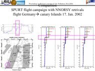
Workshop “Atmospheric monitoring <strong>and</strong> inverse modelling for verification of national <strong>and</strong> EU bottom-up GHG inventories” - reportWorkshop "Atmospheric monitoring <strong>and</strong> inverse modelling for verification of national <strong>and</strong> EU bottomupGHG inventories " - reportGeol<strong>and</strong>Jean-Christophe CalvetMétéo-France, Toulouse, FranceThe GEOLAND projectGEOLAND is carried out in the context of Global Monitoring of Environment <strong>and</strong>Security (GMES), a joint initiative of European Commission (EC) <strong>and</strong> EuropeanSpace Agency (ESA), which aims to build up a European capacity for GMES.GEOLAND is designed to fundamentally support this initiative, focusing on the GMESpriorities "L<strong>and</strong> Cover <strong>Change</strong> in Europe", "Environmental Stress in Europe", <strong>and</strong>"Global Vegetation Monitoring". In FP6, the GEOLAND integrated project started in2004 <strong>and</strong> the technical work was completed in December 2006.The ambition of the GEOLAND consortium is to develop <strong>and</strong> demonstrate a range ofreliable, affordable <strong>and</strong> cost efficient European geo-information services, supportingthe implementation of European directives <strong>and</strong> their national implementation, as wellas European <strong>and</strong> International policies. Thus, the GMES initiative is considered aunique opportunity to integrate existing technology with innovative <strong>and</strong> scientificallysound elements into sustainable services.The L<strong>and</strong> Carbon component of GEOLANDThe objective of the l<strong>and</strong> carbon component of GEOLAND is to develop a bottom-up(Fig. 1) multimodel carbon accounting system accounting for weather <strong>and</strong> climatevariability, coupled with an Earth Observation (EO) data assimilation system. Thisnew tool will support Kyoto (<strong>and</strong> post-Kyoto) reporting activities.The main achievement so far (Fig. 2) consisted in performing the 'greening' of thel<strong>and</strong> surface operational platforms of meteorological services (ECMWF <strong>and</strong> Météo-France). Namely, a CO 2 responsive capability was introduced in the l<strong>and</strong> surfacemodels <strong>and</strong> the possibility to simulate the vegetation biomass <strong>and</strong> leaf area index.ECMWF is now ready to simulate the terrestrial carbon flux at a global scale with aspatial resolution of 25 km. The modelled carbon flux is fully consistent with themodelled water flux, soil moisture, vegetation biomass <strong>and</strong> leaf area index.A demonstration EO data assimilation system was implemented over southwesternFrance (Fig. 3), <strong>and</strong> a simplified version was successfully applied at a global scale.ProspectsFuture activities will focus on the representation of carbon storage <strong>and</strong> soilrespiration in the modelling platforms of meteorological services, on the developmentof the operational use of EO data assimilation, on the improvement of the spatialresolution over Europe (1-10 km), <strong>and</strong> on linking the products with forest <strong>and</strong> soilcarbon inventory activities in Europe.38