
Create successful ePaper yourself
Turn your PDF publications into a flip-book with our unique Google optimized e-Paper software.
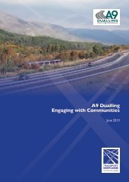
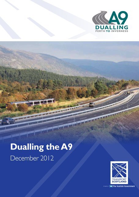
<strong>Dualling</strong> <strong>the</strong> <strong>A9</strong><strong>Dualling</strong> <strong>the</strong> <strong>A9</strong> between Perth & InvernessThe <strong>A9</strong> is <strong>the</strong> major link roadbetween <strong>the</strong> Central Belt and<strong>the</strong> far north of <strong>Scotland</strong>. At273 miles from Dunblane toThurso, it is <strong>the</strong> longest trunkroad in <strong>Scotland</strong> and <strong>the</strong> fifthlongest in <strong>the</strong> whole of <strong>the</strong>United Kingdom.The intention to fully dual<strong>the</strong> section of <strong>the</strong> <strong>A9</strong> betweenPerth and Inverness was firstannounced as part of <strong>the</strong> ScottishGovernment’s blueprint fortransport investment priorities overtwo decades, <strong>the</strong> Strategic <strong>Transport</strong>Projects Review (STPR) in 2008.A timescale for this work wasconfirmed in December 2011,when <strong>the</strong> Scottish Ministerspublished <strong>the</strong>ir Infrastructure andObjectives for dualling <strong>the</strong> <strong>A9</strong><strong>Dualling</strong> <strong>the</strong> <strong>A9</strong> between Perthand Inverness will improve <strong>the</strong>operational performance andlevel of service by:• Reducing journey times• Improving journey time reliability.The sectionsto be dualledtotal around 129kilometres (80miles).It will also improve safety formotorised and non-motorised usersby:• Reducing accident severity• Reducing driver stress.Key factsProject key facts include:• This will be one of <strong>the</strong> biggestinfrastructure projects in<strong>Scotland</strong>’s history• The <strong>A9</strong> is <strong>the</strong> longest trunkroad in <strong>Scotland</strong>, with <strong>the</strong> Perthto Inverness section forming177 kilometres (110 miles) of<strong>the</strong> total• The combined total of <strong>the</strong>Investment Plan and announced<strong>the</strong> <strong>A9</strong> between Perth andInverness would be dualled by2025.The project also seeks to facilitateactive travel in <strong>the</strong> corridor andenhance integration with publictransport facilities.existing dual carriagewaysections between Perth andInverness is approximately 48kilometres (30 miles)• The sections to be dualledtotal around 129 kilometres(80 miles). This is 16 times <strong>the</strong>length of <strong>the</strong> M74 Completionand eight times <strong>the</strong> length of <strong>the</strong>M80 Stepps to Haggs project.<strong>A9</strong>: Work in progressPreliminary design work on two sectionsof <strong>the</strong> <strong>A9</strong> was undertaken following <strong>the</strong>commitment to dual <strong>the</strong> <strong>A9</strong> made in <strong>the</strong>STPR in 2008.This work has allowed <strong>Transport</strong> <strong>Scotland</strong> tofind out more about <strong>the</strong> challenges involved indualling <strong>the</strong> <strong>A9</strong>.The two sections are:Luncarty to Pass of Birnam – TheMinister for <strong>Transport</strong> and Veterans announcedthat construction on this scheme would be readyto start in 2017. <strong>Transport</strong> <strong>Scotland</strong> has recentlyappointed Jacobs Engineering Ltd to progress <strong>the</strong>project.Birnam to <strong>the</strong> Tay Crossing – URS hasbeen appointed to undertake design work. Thisis a particularly challenging section and detailedoption assessment work is currently under way.In June 2012, <strong>the</strong> Cabinet Secretary forInfrastructure and Capital Investment announcedthat <strong>Transport</strong> <strong>Scotland</strong> would be accelerating<strong>the</strong> programme to dual <strong>the</strong> <strong>A9</strong> by bringingforward <strong>the</strong> scheme between Kincraigand Dalraddy to 2015/16. Atkins has beenappointed to take forward <strong>the</strong> design work.More detailed consultation on all of <strong>the</strong>seschemes will take place in 2013.Following <strong>the</strong> Cabinet Secretary’s commitmentto complete <strong>the</strong> dualling of <strong>the</strong> <strong>A9</strong> by 2025, wenow need to undertake route-wide constraintsmapping and survey work to allow us to startdesign work on <strong>the</strong> remainder of <strong>the</strong> route.The key objectiveof this programmeis to be ready tostart constructionin 2015/16 at <strong>the</strong>Kincraig-Dalraddysection andcomplete <strong>the</strong> fullproject by 2025.Where <strong>the</strong> workwill take placeThere are a number of sections ofsingle carriageway to be dualledbetween Perth and Inverness.These are:• Luncarty to Pass of Birnam• Pass of Birnam to Ballinluig• Pitlochry to Killiecrankie• Killiecrankie to Glen Garry• Glen Garry to Crubenmore• Crubenmore to Slochd (includesKincraig-Dalraddy scheme)• Tomatin to Moy.Those sections of dual carriagewayalready in place will also be upgraded tomodern standards.The key objective of this programmeis to be ready to start construction in2015/16 at <strong>the</strong> Kincraig-Dalraddy sectionand complete <strong>the</strong> full project by 2025.© All photos are copyright of Scottish Natural HeritageMeeting <strong>the</strong> environmental challengesThe <strong>A9</strong> passes through areaswhich are of outstanding wildlifeand scenic significance, some ofwhich are nationally and eveninternationally renowned.It is <strong>the</strong>refore extremely importantthis natural heritage is conserved, notonly for its inherent beauty, but also forits contribution to <strong>the</strong> tourist industry.In particular, <strong>the</strong> <strong>A9</strong> passes through<strong>the</strong> Cairngorms National Park, whichis Britain’s largest National Park. Theroute of <strong>the</strong> <strong>A9</strong> also takes it throughor close to a significant number ofenvironmentally designated sitesincluding:All maps are based upon OrdnanceSurvey material with <strong>the</strong> permissionof Ordnance Survey on behalf of <strong>the</strong>controller of Her Majesty’s StationeryOffice. © Crown Copyright 2012. Anyunauthorised reproduction infringes Crowncopyright and may lead to prosecution orcivil proceedings. Scottish Executive licencenumber: SE 100046668 2012.• Sites of Special Scientific Interest(SSSI): those areas that ScottishNatural Heritage considersto best represent our naturalheritage, taking account ofdiversity of plants, animals andhabitats, rocks and landforms,or a combination of naturalfeatures• Special Areas of Conservation(SAC) and Special ProtectionAreas (SPA): <strong>the</strong>se are sitesdesignated under <strong>the</strong> Habitatsor Birds Directives and areinternationally important forthreatened habitats and species• Ramsar sites: internationallyimportant wetland sites• National Scenic Areas: <strong>the</strong>reare 40 National Scenic Areasin <strong>Scotland</strong> which represent<strong>Scotland</strong>’s finest landscapesthanks to <strong>the</strong>ir outstandingscenery.<strong>Transport</strong> <strong>Scotland</strong> regularlyengages with key statutory authoritiesincluding Scottish Natural Heritage,<strong>the</strong> Scottish Environment ProtectionAgency and Historic <strong>Scotland</strong>to identify where <strong>the</strong> greatestenvironmental challenges will be.Assessing <strong>the</strong>engineering challengeThe Engineering Assessmentprocess will consider optionsto improve <strong>the</strong> route whichmeet <strong>the</strong> objectives of <strong>the</strong>scheme.Existing information is beingcollated and, where this isdeemed inadequate, surveys willbe undertaken to ensure <strong>the</strong>results of this assessment arecomprehensively reported.Route optionsFactors to be considered whenlooking at ways to improve <strong>the</strong>existing route and develop a fulldual carriageway include:• Applying <strong>the</strong> appropriatedesign standards for <strong>the</strong>schemes to ensure safeand efficient proposals aredeveloped• The overall condition andfeasibility of improving <strong>the</strong>existing road, includingstructures and pavementWho uses <strong>the</strong> <strong>A9</strong>?The <strong>A9</strong> is currently usedby a variety of differentroad users throughout <strong>the</strong>year, with a large seasonalvariation in <strong>the</strong> numberof vehicles using certainstretches of <strong>the</strong> road.In some key areas, vehiclenumbers more than doubleduring summer with around 1in 5 cars carrying passengerson tourist trips. Traffic on <strong>the</strong>sou<strong>the</strong>rn sections of <strong>the</strong> <strong>A9</strong> canreach around 16,000 vehicles perday during <strong>the</strong>se peak periods.A survey of <strong>the</strong> <strong>A9</strong> betweenPerth and Inverness in 2012 hascondition, drainage andgeometry• Topography of <strong>the</strong> area• Problems associated withdrainage and groundconditions• Environmental constraints,such as Areas of OutstandingNatural Beauty• Junction and access provision• Lay-bys and rest arearequirements.Once a preferred option hasbeen determined for each section,more detailed issues such assignage, lighting and constructionwill be assessed and consultedupon.Preliminary constraints mappinghas begun and early plans areavailable for consideration andinput. <strong>Transport</strong> <strong>Scotland</strong> is alsoinviting landowners who may beaffected by <strong>the</strong> scheme to speak to<strong>the</strong> organisation’s advisors.indicated that almost half of alldrivers using <strong>the</strong> <strong>A9</strong> are makingjourneys over 100 miles long andthat 9 out of 10 people travellingbetween Perth and Invernessopt to make <strong>the</strong> journey by carra<strong>the</strong>r than by bus or train, witha typical journey time of 90-110minutes.Commercial traffic (LGVs,HGVs) constitute around 1in 5 of all vehicles on <strong>the</strong> <strong>A9</strong>between Perth and Inverness.Close to <strong>the</strong> cities of Perthand Inverness, over half <strong>the</strong>drivers use <strong>the</strong> road at leastonce a week.2 3 4
<strong>Dualling</strong> <strong>the</strong> <strong>A9</strong>Safety firstWhile <strong>the</strong> <strong>A9</strong> has areputation for being adangerous road, <strong>the</strong> sectionbetween Perth and Invernessactually has a better-thanaveragetrunk road safetyperformance.The accident rate for <strong>the</strong> singlecarriageway section betweenPerth and Inverness is 8.24accidents per 100 million vehiclemovements, which is less than halfthat of <strong>the</strong> Scottish trunk roadaverage.While accident levels are belowaverage, <strong>the</strong> number of fatal orserious injury accidents is higherthan <strong>the</strong> national average. Onedeath in a road accident is one toomany and reducing <strong>the</strong> severity ofaccidents is a key objective for <strong>the</strong><strong>A9</strong> dualling scheme.It is not always possible todetermine <strong>the</strong> cause of everyaccident, but <strong>the</strong>re is a generalunderstanding that <strong>the</strong> lackof guaranteed overtakingopportunities on <strong>the</strong> <strong>A9</strong> leads todriver frustration.Relieving this frustration andstress is one of <strong>the</strong> key objectivesof <strong>the</strong> <strong>A9</strong> dualling project.All maps are based upon OrdnanceSurvey material with <strong>the</strong> permissionof Ordnance Survey on behalf of <strong>the</strong>controller of Her Majesty’s StationeryOffice. © Crown Copyright 2012. Anyunauthorised reproduction infringes Crowncopyright and may lead to prosecution orcivil proceedings. Scottish Executive licencenumber: SE 100046668 2012.Accessibility –existing activetravel routes/core path plan<strong>Transport</strong> <strong>Scotland</strong>has met with localauthorities and Regional<strong>Transport</strong> Partnershipsand organisations such asSustrans, CTC <strong>Scotland</strong>,HITRANS, The British HorseSociety, Ramblers <strong>Scotland</strong>and ScotWays to maximise<strong>the</strong> opportunities <strong>the</strong>dualling of <strong>the</strong> <strong>A9</strong> presentsfor cyclists, ramblers,equestrians and o<strong>the</strong>r nonmotorisedroad users.Data on <strong>the</strong> existing active traveland recreational routes is beingcollated at present and suggestionson <strong>the</strong> location of any localtransport links are welcome.Suggestions on<strong>the</strong> locationof any localtransport linksare welcome.What is being done to improve safety on <strong>the</strong> <strong>A9</strong> today?<strong>Transport</strong> <strong>Scotland</strong>’sStrategic Road SafetyPlan contains an actionto produce Route SafetyFiles for each distinctpart of <strong>the</strong> motorway andtrunk road network toinform future road safetyprioritisation.Route Safety Group meetingsare also regularly held withkey stakeholders including <strong>the</strong>Police, local authorities andSafety Camera Partnerships.These help identify <strong>the</strong> stepstowards reducing <strong>the</strong> numberof accidents and casualties on<strong>the</strong> specific route.Scottish Ministers have asked<strong>the</strong> <strong>A9</strong> Route Safety Group,which is looking at improvingroad safety on <strong>the</strong> <strong>A9</strong> betweenKeir Roundabout and Thurso,to investigate and recommenda series of urgent additionalactions to fur<strong>the</strong>r improvesafety on <strong>the</strong> <strong>A9</strong>.A range of options iscurrently being assessed,including improved consistencyof signing and lining, improvedgeometry, variable messagingsigns and average speedcameras.The <strong>A9</strong> Route Safety Grouphas also recently launched anew journey time informationsystem to help address driverfrustration associated withunreliable journey times.5
All maps are based upon OrdnanceSurvey material with <strong>the</strong> permissionof Ordnance Survey on behalf of <strong>the</strong>controller of Her Majesty’s StationeryOffice. © Crown Copyright 2012. Anyunauthorised reproduction infringes Crowncopyright and may lead to prosecution orcivil proceedings. Scottish Executive licencenumber: SE 100046668 2012.PerthLuncarty,Redgorton,and MoneydieCommunity CouncilsTullochLagganNorth MuirtonDalwhinnieStrathnairnNewtonmoreStrathdearnWhat happens next?KingussieThe information collected through surveywork and this consultation exercise will beused to inform <strong>the</strong> engineering and strategicenvironmental assessment work. Theoutcome of that work will be consulted on in2013, allowing for <strong>the</strong> identification of routeoptions to begin.There will be fur<strong>the</strong>r opportunities for publicconsultation throughout <strong>the</strong> design and developmentprocess and <strong>Transport</strong> <strong>Scotland</strong> will consider pointsraised during consultation and act upon <strong>the</strong>m whereCarrbridgeKincraigBlair Atholl and StruanBoat of GartenAviemoreKilliecrankie and FincastlePitlochry and MoulinMid Atholl, Strathtay and GrandtullyDunkeld and BirnamInvernessCentralCulcabock and DrakiesAuchtergavenInverness SouthRaigmoreSpittalfield and DistrictStanleySmithton and CullodenWesthillreasonable and appropriate.In addition to formal consultation, <strong>Transport</strong><strong>Scotland</strong> hopes to establish a regular forum withcommunity councils along <strong>the</strong> <strong>A9</strong>. This will allowcommunities to be updated on <strong>the</strong> process andprogress in <strong>the</strong>ir areas.Any comments on <strong>the</strong> <strong>A9</strong> <strong>Dualling</strong> programmecan be sent to: <strong>A9</strong> <strong>Dualling</strong> team, MTRIPS2,<strong>Transport</strong> <strong>Scotland</strong>, Buchanan House, 58 PortDundas Road, Glasgow G4 0HF. E-mail: a9dualling@transportscotland.gsi.gov.ukEngaging <strong>the</strong>community<strong>Transport</strong> <strong>Scotland</strong> hasalready been engagingwith <strong>the</strong> communitiesaffected by <strong>the</strong> current <strong>A9</strong>projects at Luncarty toPass of Birnam, Birnam toTay Crossing and Kincraigto Dalraddy, and thiswork will be rolled out too<strong>the</strong>r communities along<strong>the</strong> length of <strong>the</strong> route asdesign work proceeds.A rolling programme ofregular engagement fromPerth to Inverness willbe undertaken to ensurebusinesses and individualsaffected by <strong>the</strong> work over <strong>the</strong>next decade and beyond arekept fully informed.More importantly, this willensure important feedbackis taken into account as <strong>the</strong>project is designed, procuredand constructed.As well as bringing benefits,road construction comeswith impacts for those livingalong <strong>the</strong> route, which is whycommunities lie at <strong>the</strong> heart of<strong>Transport</strong> <strong>Scotland</strong>’s planning.The local perspectiveon <strong>the</strong> main risks andopportunities to <strong>the</strong><strong>A9</strong> dualling is not onlywelcome, but vital.Fur<strong>the</strong>rinformationFor moreinformation on<strong>the</strong> proposals for<strong>the</strong> <strong>A9</strong> dualling,please visit <strong>the</strong>project page on<strong>the</strong> <strong>Transport</strong><strong>Scotland</strong>website at: www.transportscotland.gov.uk/a9dualling6