Road Guide to the Rural Address System - Clatsop County Oregon
Road Guide to the Rural Address System - Clatsop County Oregon
Road Guide to the Rural Address System - Clatsop County Oregon

You also want an ePaper? Increase the reach of your titles
YUMPU automatically turns print PDFs into web optimized ePapers that Google loves.
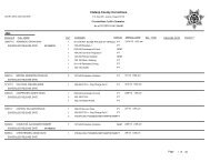
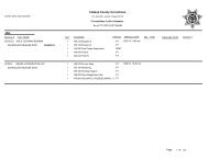
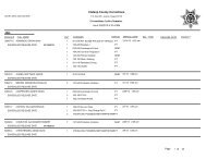
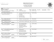
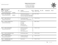
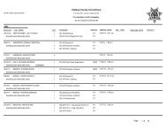
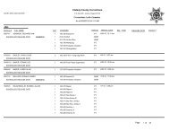
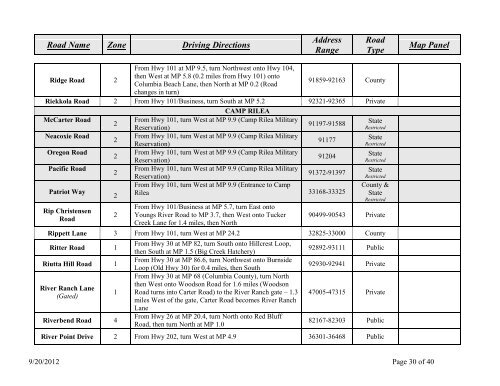
<strong>Road</strong> Name Zone Driving Directions<strong>Address</strong>Range<strong>Road</strong>TypeMap PanelRidge <strong>Road</strong> 2From Hwy 101 at MP 9.5, turn Northwest on<strong>to</strong> Hwy 104,<strong>the</strong>n West at MP 5.8 (0.2 miles from Hwy 101) on<strong>to</strong>Columbia Beach Lane, <strong>the</strong>n North at MP 0.2 (<strong>Road</strong>91859-92163 <strong>County</strong>changes in turn)Riekkola <strong>Road</strong> 2 From Hwy 101/Business, turn South at MP 5.2 92321-92365 PrivateCAMP RILEAMcCarter <strong>Road</strong>Neacoxie <strong>Road</strong><strong>Oregon</strong> <strong>Road</strong>Pacific <strong>Road</strong>Patriot WayRip Christensen<strong>Road</strong>222222From Hwy 101, turn West at MP 9.9 (Camp Rilea MilitaryReservation)91197-91588From Hwy 101, turn West at MP 9.9 (Camp Rilea MilitaryReservation)91177From Hwy 101, turn West at MP 9.9 (Camp Rilea MilitaryReservation)91204From Hwy 101, turn West at MP 9.9 (Camp Rilea MilitaryReservation)91372-91397From Hwy 101, turn West at MP 9.9 (Entrance <strong>to</strong> CampRilea 33168-33325From Hwy 101/Business at MP 5.7, turn East on<strong>to</strong>Youngs River <strong>Road</strong> <strong>to</strong> MP 3.7, <strong>the</strong>n West on<strong>to</strong> TuckerCreek Lane for 1.4 miles, <strong>the</strong>n NorthStateRestrictedStateRestrictedStateRestrictedStateRestricted<strong>County</strong> &StateRestricted90499-90543 PrivateRippett Lane 3 From Hwy 101, turn West at MP 24.2 32825-33000 <strong>County</strong>Ritter <strong>Road</strong> 1Riutta Hill <strong>Road</strong> 1River Ranch Lane(Gated)Riverbend <strong>Road</strong> 41From Hwy 30 at MP 82, turn South on<strong>to</strong> Hillcrest Loop,<strong>the</strong>n South at MP 1.5 (Big Creek Hatchery)From Hwy 30 at MP 86.6, turn Northwest on<strong>to</strong> BurnsideLoop (Old Hwy 30) for 0.4 miles, <strong>the</strong>n SouthFrom Hwy 30 at MP 68 (Columbia <strong>County</strong>), turn North<strong>the</strong>n West on<strong>to</strong> Woodson <strong>Road</strong> for 1.6 miles (Woodson<strong>Road</strong> turns in<strong>to</strong> Carter <strong>Road</strong>) <strong>to</strong> <strong>the</strong> River Ranch gate – 1.3miles West of <strong>the</strong> gate, Carter <strong>Road</strong> becomes River RanchLaneFrom Hwy 26 at MP 20.4, turn North on<strong>to</strong> Red Bluff<strong>Road</strong>, <strong>the</strong>n turn North at MP 1.092892-93111 Public92930-92941 Private47005-47315 Private82167-82303 PublicRiver Point Drive 2 From Hwy 202, turn West at MP 4.9 36301-36468 Public9/20/2012 Page 30 of 40