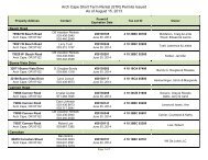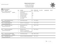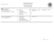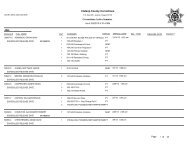
here - Clatsop County Oregon
here - Clatsop County Oregon
here - Clatsop County Oregon

You also want an ePaper? Increase the reach of your titles
YUMPU automatically turns print PDFs into web optimized ePapers that Google loves.
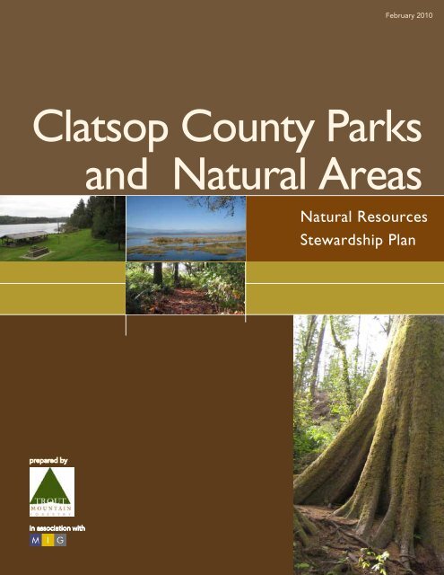
February 2010<strong>Clatsop</strong> <strong>County</strong> Parksand Natural AreasNatural ResourcesStewardship Plan
Natural Resources Stewardship PlanSection 1: Policy RecommendationsIntroduction and Executive Summary.......................1.2The Inventory and Assessment Process....................1.3Ownership Objectives and Resource Policies...........1.6Resource Policies..................................................1.7Synthesis of Findings.............................................1.8General Recommendations and .Implementation Strategies....................1.12Property Status/Disposition Recommendations.......1.15Section 2: Findings and Recommendations<strong>County</strong> Parks.......................................................2.2Recreation Lands...............................................2.24Section 3: AppendixAppendix...........................................................3.2
<strong>Clatsop</strong> <strong>County</strong> Parks
Section 1Policy Recommendations
Section 1Introduction and Executive Summary<strong>Clatsop</strong> <strong>County</strong>’s abundant beauty and rich natural resources are well represented in the <strong>County</strong>’spark system. In 2006, the <strong>County</strong> Parks Master Plan was adopted, and it provides a comprehensiveoverall assessment of park resources and facilities, as well as opportunities and challenges facing thepark system. A key finding of the Plan was that further assessment of the natural resources in theparks is needed. Indeed, the planning process revealed that a system-wide natural resources inventorywould be an important step in enabling the <strong>County</strong> to fully capitalize on the recreational and wildlifehabitat potential of these park and natural area lands.Our assessment team worked collaboratively with the <strong>County</strong> Recreational Lands Planning and AdvisoryCommittee, county staff, and local conservation groups to develop a comprehensive approachto recreational land stewardship for the <strong>County</strong>’s portfolio of properties. <strong>Clatsop</strong> <strong>County</strong>’s parks andnatural area ownership addressed in this process consists of 11 parks totaling 545 acres and six recreation/naturalarea sites totaling 282 acres of land. The assessment was focused on the key issues ofinvasive vegetation, erosion, safety hazards to the public, dumping, flooding and tree windthrow dangers.This report includes detailed findings and recommendations for each parcel, as well as a broaderpolicy framework to guide future decision making around natural resource issues.Trail at Big Creek <strong>County</strong> Park1.6 | <strong>Clatsop</strong> <strong>County</strong> Parks—Natural Resources Stewardship Plan
Policy RecommendationsSummary of FindingsTaken together, the <strong>Clatsop</strong> <strong>County</strong> Parks andNatural Areas contain a tremendous richness anddiversity of wildlife habitats and recreation opportunities.Of the seventeen properties we studied:• Nine are located on major fish-bearing streamsor rivers• Three are located on lakes• Three contain old growth (trees more than 150years old)• Five contain or are immediately adjacent toactive bald eagle nests• Four contain significant forested wetlands• Five contain old farm fields or other clearingsthat add to habitat diversityBattle Creek tidelandsThe threats to the ecological integrity of these properties include:• The spread of non-native invasive plants, which can displace native vegetation and reduce habitatand scenic values• Erosion near streams due to poorly designed trails and/or overuse, as well as natural streamchannel migration processes• Natural events such as flooding and windstorms• Human caused disturbances such as timber trespass, salvage logging, or littering/dumpingOther issues we identified include safety hazards, such as leaning/diseased trees near trails, roads or facilities,and issues related to ecological functions, such as lack of large woody debris in streams, whichreduces fish habitat values.With this natural resources inventory in place, the <strong>County</strong> can implement stewardship projects targetingpriority areas and issues, in collaboration with key partner groups.The Inventory and Assessment ProcessPurpose of the ProjectThe purpose of this resource inventory and assessment is to provide <strong>County</strong> officials and staff withguidance for the integrated management of the <strong>County</strong>’s parks and natural areas. These resources in-Section 1 Policy Recommendations | 1.7
Section 1clude sensitive fish-bearing streams and rivers, saltwater and freshwater wetlands, healthy and diverseupland forests and special wildlife habitat, including older forest stands and legacies. Habitat stabilizationand conservation strategies are discussed. Opportunities for habitat restoration and improvementsand additional protections in sensitive areas are proposed. Accurate resource information andcomprehensive management strategies are critical to ensure the responsible long-term stewardship ofthese important properties.Specifically, this resource assessment serves to:• Inventory and map each property’s features, resources and conditions• Describe resource management issues• Provide an overall approach and resource policy framework to guide future management decisions• Suggest management priorities and methods for monitoring the success of stewardship activitiesThis plan establishes a framework that will guide management of the <strong>County</strong> parks and natural areasover time. It is not intended to provide all the answers for future management decisions. Periodic operatingplans will provide substantial additional detail relative to proposed activities, and may requireadditional planning and monitoring work.Inventory and Assessment ProcessThe inventory and assessment process involved several steps (Figure 1). Resource inventories andassessments were conducted on each <strong>County</strong> property. Management strategies and policies were consideredfor the ownership as a whole, and recommended actions were detailed for each of the parksand natural areas.Figure 1Conduct Resource Inventory andAssessmentEstablish Goals andObjectivesReview assessment findingsand resource conditionsIdentify Needs &OpportunitiesRecommend Actions1.8 | <strong>Clatsop</strong> <strong>County</strong> Parks—Natural Resources Stewardship Plan
Policy RecommendationsField survey work involved reconnaissance of each site, delineation into major vegetation/habitattypes, and a sampling method employing intuitive meandering transects. This strategy allowed surveyorsto focus in on areas with high likelihood of invasive species, for example.Features recorded in the hand-held Global Positioning System (GPS) computers, and t<strong>here</strong>fore usedin the maps include:• Individual old growth trees (if occurring in a matrix of younger forest)• Old growth stands• Springs or seeps• Wetlands• Unmapped streams• Waterfalls• Significant wildlife habitat elements such as old snags, eagle nests, areas of heavy deer or elk use, etc.• Significant park improvements that are not detectable through inspection of aerial imagery, such astrails or other features that may be obscured by tree cover• Safety hazards• Areas of significant erosion or riparian instability• Littering or dumpingThis plan was developed in consultation with numerous public agencies, conservation groups, andprivate citizens. The process began in the spring of 2009 by inviting the Recreation Lands AdvisoryCommittee as well as additional stakeholders on a tour of several of the <strong>County</strong>’s properties and aworkshop to describe the planning process. Following that tour, an e-mail list of stakeholders wasdeveloped, including more than two dozen representatives from local agencies, conservation groups,and private citizens. As maps and draft recommendations were developed through the remainder ofthe process, they were distributed to this list for comments and suggestions, and to keep the communityapprised of the process and findings. In December 2009, a public meeting was held in Astoria topresent initial findings and recommendations and solicit additional input. Key results of that meetingare presented in Appendix A.Representatives from the following organizations have participated in the planning process:• <strong>Clatsop</strong> <strong>County</strong> Department of Transportation and Development• <strong>Clatsop</strong> <strong>County</strong> Parks• <strong>Clatsop</strong> <strong>County</strong> Property Division• <strong>Oregon</strong> Department of Forestry• <strong>Oregon</strong> Department of Fish & Wildlife• <strong>Clatsop</strong> Soil and Water Conservation District• <strong>Clatsop</strong>/Tillamook Natural Resource Conservation ServiceSection 1 Policy Recommendations | 1.9
Section 1• Necanicum Watershed CouncilYoungs River as seen from the Astoria Column• North Coast Land Conservancy• Columbia River Estuary Study Task Force (CREST)• North Coast Watershed Association• <strong>Oregon</strong> State University Extension Service• Columbia Land Trust• Private citizensOwnership Objectives and Resource PoliciesOwnership ObjectivesThe properties are actively managed for multiple objectives (cited in the <strong>County</strong> Parks Master Plan)including:• Recreation (public health and wellness);• Open space;• Plant and animal habitat;• Economic contribution (enhances value for adjacent homeowners and businesses);• Tourism;• Water quality and flood control;• Cultural and historic preservation (historic buildings and biological legacies); and• Public education (natural resource knowledge and appreciation).1.10 | <strong>Clatsop</strong> <strong>County</strong> Parks—Natural Resources Stewardship Plan
Policy RecommendationsWith this vision, the <strong>County</strong> parks andnatural areas will provide a model for sustainableresource management that will bean inspiration and legacy of stewardship forfuture citizens. The <strong>County</strong>’s demonstrationof stewardship practices will encourage otherswho strive to become better caretakers ofour important natural resources.Resource PoliciesVegetation ManagementInvasive SpeciesIt is the policy of <strong>Clatsop</strong> <strong>County</strong> to promotenative plant communities and activelymonitor, control and reduce invasive plantpopulations.Natural Area SuccessionClaremont Road forestIt is the policy of <strong>Clatsop</strong> <strong>County</strong> tomanage their properties to provide a variety of types of vegetation communities and habitat conditions.Stable, later successional plant communities will be fostered and protected.Restorative ApproachIn ecosystems that are being degraded or threatened by invasive species or disturbance, it is the policyof <strong>Clatsop</strong> <strong>County</strong> to stabilize ecosystems to prevent degradation first, then restore important areasw<strong>here</strong> it is feasible and economically sustainable.Management Capacity and ResourcesUse of Available ResourcesIt is the policy of <strong>Clatsop</strong> <strong>County</strong> to use parks staff and employee time on supervision, maintenanceand monitoring tasks; when special improvement or restoration projects are undertaken, the <strong>County</strong>will seek partners within the conservation and consulting community for managerial, technical andfunding support.Park DevelopmentDeveloped versus Natural AreasIt is the policy of <strong>Clatsop</strong> <strong>County</strong> to provide recreational opportunities within its parks and naturalareas in a safe and environmentally sustainable manner. New developed areas and trails will be designedand maintained to insure the minimum impact on natural ecosystems and plant communities.Areas with rare or threatened habitats will be protected from development.Section 1 Policy Recommendations | 1.11
Section 1Public EducationIt is the policy of <strong>Clatsop</strong> <strong>County</strong> to provide educational opportunities to the recreating public toimprove understanding and appreciation of natural ecosystems.Property DispositionIt is the policy of <strong>Clatsop</strong> <strong>County</strong> to maintain ownership of current parks and natural areas, unlessthe property does not contribute to meeting <strong>County</strong> objectives listed above, or the park or naturalarea could be transferred to a public entity or conservation organization that has similar objectives.Synthesis of FindingsMaps provided in Section 2 include substantial spatial detail about locations of invasives and otherissues identified during the inventory process. In addition, we have synthesized findings in order toprovide <strong>County</strong> managers and other stakeholders with a framework for assessing various propertiesand issues.The first level of analysis is categorizing major habitat types across all the properties. We used broadhabitat types that make sense to professional resource managers while remaining accessible to theinterested public.Figure 2 provides the summary for this analysis. Habitat types are grouped into Blue (water relatedhabitats), Green (forest habitats at different successional stages), and Yellow (early successional orgrassland communities).Summary of wildlife habitat types on <strong>Clatsop</strong> <strong>County</strong> propertiesFigure 2ParksRec. LandsPropertySize(acres)ForestedwetlandsWetlands/MarshRiparianforestOld growthforestMid-agedforest (80-150 yrs)Youngforest (
Policy RecommendationsThe second level of analysis focuses on the threats identified during the inventory process. Theseinclude those the <strong>County</strong> specifically requested we analyze, such as invasive species, safety hazards,and erosion. We extended the analysis to incorporate other natural disturbances such as flooding andwindthrow, as well as human-caused disturbances such as salvage logging or littering.Figure 3 summarizes this analysis by visually displaying the range of threats to ecological integrity ateach property, along with a qualitative assessment of the nature of the risk in each case. As an example,the Williamsport Road area tracts contain significant areas of established invasive plants, andmoderate risk for windthrow due to topography and stand conditions. In addition, the property wassalvage logged in 2008. Although that process was completed using lower impact tower logging techniquesfor log suspension and high standards were implemented for retention of wildlife trees, muchof the soil in the harvest area was disturbed, providing an opportunity for aggressive invasive plants tobegin colonizing the area. This additional risk factor increases the likelihood for expansion of nonnativeinvasive plants. Finally, the property is adjacent to the waste transfer station, and past dumpinghas occurred on and around the property. Taken together, these factors provide for an overall assessmentof the threats faced by each property relative to the others.Figure 3Summary of ecological threats to <strong>Clatsop</strong> <strong>County</strong> propertiesPropertySize(acres)InvasivesThreatsSafetyhazards Erosion Flooding WindthrowRecentlyloggedTimbertrespassBig Creek Park 36 DumpingCarnahan Park 31 Cullaby Lake Park 165 David Douglas Park 64 ParksRec. LandsLee Wooden Park 47 John Day Park/Boat Ramp 58 Klootchy Creek Park 25 Nehalem Park 49 North Fork Nehalem Park 3 Sigfridson Park 64 Smith Lake Park 3 Battle Creek Tidelands 13 Claremont Road tracts 3 Twilight Eagle Sanctuary 15 Area east of Astoria Column 121 Williamsport Road area 72 Cedar Street Wetlands 58 Total 827very minor issue, notlikely to causedegradationa problem in some areas, some degradationpossiblea significant problem,degradation likelySection 1 Policy Recommendations | 1.13
Section 1Policeman’s helmetEnglish ivyTaking this analysis one step further, we created a framework for comparing current ecological healthand risk of degradation, based on the factors identified in Figure 3. (Figure 4).Ecological health and risk of degradation on <strong>Clatsop</strong> <strong>County</strong> propertiesFigure 4Low Risk HighBattle CreekTidelandsKlootchy CreekWilliamsportRoadSmith LakeTwilight EagleBig CreekSigfridsonRadio TowerCullabyNorth ForkNehalemLee WoodenJohn DayCarnahanCedar StreetWetlandsClaremont RoadNehalemDavidDouglasLow Ecological health High Parks Recreation lands1.14 | <strong>Clatsop</strong> <strong>County</strong> Parks—Natural Resources Stewardship Plan
Policy RecommendationsTansy ragwortHimalayan blackberryFinally, since invasive species control has continually risen to the top of the list of priorities duringthis stewardship planning process, we analyzed the data in Section 2 to create Figure 5, which groupsthe properties into high, medium and low infestation levels and identifies the species present oneach property.Figure 5Summary of invasive species on <strong>Clatsop</strong> <strong>County</strong> Parks and Rec. Lands propertiesProperty Size (acres)HimalayanblackberrySpeciesScotchbroom English ivy English holly Knotweed ClematisPoliceman'shelmetTansyragwortKlootchy Creek Park 25 OtherHighSigfridson Park 64 Williamsport Road area 72 Cullaby Lake Park 165 John Day Park/Boat Ramp 58 Cedar Street Wetlands 58 Carnahan Park 31 MediumArea east of Astoria Column 121 Smith Lake Park 3 Big Creek Park 36 David Douglas Park 64 Twilight Eagle Sanctuary 15 North Fork Nehalem Park 3 Battle Creek Tidelands 13LowLee Wooden Park 47 Nehalem Park 49 Claremont Road tracts 3 Total 827present, but only a fewplantsscattered on the propertyor limited to a coupleproblem areaswidespread or with areas ofsubstantial infestationSection 1 Policy Recommendations | 1.15
Section 1General Recommendations and Implementation StrategiesGeneral RecommendationsSafety HazardsSeveral safety hazards have been identified bythe assessment team, including hazard trees,unsafe trails and a deteriorating boat ramp.These problems should be addressed first.Control of Invasive PlantsSystem-wide, the most pressing problem is theneed to control invasive vegetation, particularlyin areas of recent disturbance (KlootchyCreek Park and Williamsport Road) or otherareas with high potential for rapid spread(Sigfridson Park and Cullaby Lake Park). Thegeneral management approach and strategy isdiscussed below.Cedar Street wetlands spruce blowdownDeveloped AreasMowing should be adjusted to allow natural regeneration on steeper slopes and in riparian or bufferareas. T<strong>here</strong> are opportunities to reduce mowing costs and improve habitat, particularly in Carnahan,Cullaby and Big Creek Parks. Trail improvements, reconstruction, or closures should be consideredfor areas w<strong>here</strong> trails are eroding or w<strong>here</strong> they appear to be excessive (Cullaby, Big Creek). New trailsshould be planned to improve visitor experience at; Cullaby Lake wetlands, Carnahan upland forestCedar Street Wetlands, and possibly at Smith Lake. Entry orientation and environmental educationsignage could be provided at all parks and natural areas to help citizens become better stewardsof their natural resources. Additional or improved public access could be planned for parks such asNehalem/Red Bluff, David Douglas and Sigfridson, as well as at most natural areas.Status of PropertiesThe <strong>County</strong> requested a review of its Parks and Recreation Lands portfolio to identify opportunitiesw<strong>here</strong> a land sale or transfer may be desirable and appropriate. Of the <strong>County</strong> Parks, only one (NorthFork Nehalem Park) was assessed for possible trade or sale. All six natural areas properties were analyzedfor sale or transfer. See Section 6 below for a discussion of the factors considered and specificrecommendations. In summary, it is recommended that North Fork Nehalem Park be retained, BattleCreek Tidelands be sold, and Cedar Street Wetlands be retained or transferred to retain wetlands.1.16 | <strong>Clatsop</strong> <strong>County</strong> Parks—Natural Resources Stewardship Plan
Policy RecommendationsImplementation StrategiesCurrent Management CapacityThe seventeen properties of the <strong>County</strong> Parks and natural area system are managed by a NaturalResources Manager, and this position’s responsibilities are evenly divided between the <strong>County</strong>’sfisheries program and park lands. In addition, t<strong>here</strong> is one full time Park Ranger and two seasonal (sixmonths/year) part-time positions (20 hours/week and 30 hours/week). The managementfocus is maintenance and management of the facilities and high-use areas of the developed parks.Current staffing provides only limited capacity for managing and implementing additional stewardshipactivities.Develop PartnershipsOutside partners (watershed councils, conservation groups, government agencies) have technical,managerial and financial resources that will be crucial to successful implementation and monitoringof recommended activities. The <strong>County</strong> should actively seek help from these groups and strengthenexisting relationships. Figure 6 demonstrates the two phases of invasive plant control and suggeststhat outside funding may be required to attain conditions that can readily be maintained. Once theseconditions are achieved, maintenance costs should be relatively low and stable over time.Figure 6Long-term Financing for Invasives ControlRehabilitationphaseTotal costsCostHypotheticalagencyfundingTimeMaintenancephaseSection 1 Policy Recommendations | 1.17
Section 1Nehalem <strong>County</strong> ParkProject Implementation and Monitoring PlansBrief, site-specific operational plans that document and implement stewardship activities will be ahelpful management tool. Such plans should include baseline documentation of existing conditions(e.g. photos, maps and descriptions) and provisions for project follow-up and monitoring.Invasive Control ApproachGiven the current field conditions and the nature and implications of the threat from non-nativevegetation, the <strong>County</strong>’s strategy for invasive plant control should include:• Stop the spread of existing infestations• Protect the best and least impacted properties and areas• Focus on rapid and new invaders• Be pragmatic, i.e. do not try to do everything everyw<strong>here</strong><strong>County</strong> Staff Skill DevelopmentActive management of natural resources will be a new activity for <strong>County</strong> staff. T<strong>here</strong> will be a learningcurve that may require new training, equipment, trial and error. A maintenance review or auditcould be done to help identify opportunities to reduce or change mowing patterns. New technicalskills needed may include invasive plant identification and BMPs for control.MonitoringMeasurement of resource conditions on a periodic basis provides a baseline of initial conditions, andhelps to measure change in the resource and impacts of management activities. Annual monitoringvisits for all properties are recommended. A property-wide reassessment should be done at least everyten years. T<strong>here</strong> may be cases w<strong>here</strong> special monitoring projects are developed to answer specific questions.These can provide educational opportunities for students or interested citizens who want to beinvolved in data collection, with coordination and evaluation support from a resource professional.A monitoring program should include: invasive species mapping, notes on habitat changes, erosion,stream changes, project implementation and effectiveness of treatments.1.18 | <strong>Clatsop</strong> <strong>County</strong> Parks—Natural Resources Stewardship Plan
Policy RecommendationsProperty Status/Disposition RecommendationsThe <strong>County</strong> has requested a review of their Parks and Recreation Lands portfolio to identify opportunitiesw<strong>here</strong> a land sale or transfer may be desirable and appropriate.ParksAmong the <strong>County</strong> Parks, only one—NorthFork Nehalem—has been specifically discussedfor potential sale or trade. The rationale for sucha transaction is the remote location of the sitefrom Astoria, w<strong>here</strong> parks personnel are based,the small size (3.5 acres) and the location of thePark adjacent to a State-operated fish hatchery.However, past discussions with the State havenot progressed, and current Recreation LandsAdvisory Committee sentiment seems to favorkeeping the Park under <strong>County</strong> ownership. Themaintenance requirements for this park are fairlylight.Recommendation: Retain <strong>County</strong> ownershipNatural AreasThe <strong>County</strong> has requested recommendations for each of the Natural Areas.Battle Creek TidelandsThis property has no legal access except via water travel, so can’t be used for public recreation. It isa small area that is highly disturbed by regular flooding and livestock grazing. The Columbia LandTrust, which owns and manages the nearby Haven Island property just downstream in Youngs River,has expressed no interest in acquiring or managing the <strong>County</strong>’s land. The <strong>County</strong> previously tried tosell the property by public auction, but t<strong>here</strong> were no bidders. A sealed bid sale might be of interest toadjoining landowners.Recommendation: Offer the property for sale by sealed bidNorth Fork Nehalem <strong>County</strong> ParkSection 1 Policy Recommendations | 1.19
Section 1Claremont Road tractsThese taxlots have no legal access, so can’t be used for public recreation. The property contains aninteresting example of older conifer forest, including at least one very large old growth spruce (82inches diameter-breast-height), and old growth down logs. Neighboring landowners have in the pastpursued ownership of the tracts, requesting that the <strong>County</strong> put them up for auction. The <strong>County</strong>has decided to maintain ownership, and we concur. The best guarantee for retaining the habitat andlegacy values of this small property would be retaining public ownership.Recommendation: Retain <strong>County</strong> ownershipTwilight Eagle SanctuaryThis taxlot contains a bald eagle nest and a variety ofother wildife habitats, and is adjacent to land ownedby the North Coast Land Conservancy and ColumbiaLand Trust. The property has a few invasives issuesthat should be addressed, but are not overwhelming.The <strong>County</strong> has leased the property to the <strong>Oregon</strong>Eagle Foundation, which officially manages the sitefor eagle habitat. The <strong>County</strong> should retain this propertyas a public natural area.Recommendation: Retain <strong>County</strong> ownershipArea east of Astoria Column/WilliamsportRoad tractsView of Columbia River from near the Twilight Eagle SanctuaryThese properties, taken together, help form an impressive natural area backdrop for the City of Astoria.The wildlife habitat and scenic values of these properties are outstanding. The Williamsport Roadtract has a long-term bald eagle nest, and t<strong>here</strong> is an active eagle nest immediately to the east of theAstoria Column tracts on City-owned land. During field work for this plan, five pileated woodpeckerswere seen on a single large snag.The <strong>County</strong> should retain ownership of these tracts while developing a partnership with the City ofAstoria to explore combining these <strong>County</strong> tax lots with City owned lands to form a single unified“Forest Park” for mutual benefit of the citizens of the City and the <strong>County</strong>. This would facilitate acoordinated approach to trail development, natural resource management and monitoring.Recommendation: Retain <strong>County</strong> ownership and explore partnership with the City of Astoria1.20 | <strong>Clatsop</strong> <strong>County</strong> Parks—Natural Resources Stewardship Plan
Policy RecommendationsCedar Street WetlandsCedar Street WetlandsThis area is a forested wetland and is providing an important water retention function that helps reducethe impact of flooding on the neighboring communities of Warrenton and Hammond. It is alsoproviding important wildlife habitat for deer, elk and many bird species. The property is surroundedon the north, west and east by housing development. To the south is a small property owned by theNorth Coast Land Conservancy.This property would make a compelling and appropriate addition to the <strong>County</strong>’s park system; however,current budget limitations make this unfeasible. Located within the Warrenton city limits, themost likely conservation options would be: 1) Negotiating a transfer or sale to the City or Warrentonwith a deed restriction requiring park or open space designation (grant funding through the <strong>Oregon</strong>Watershed Enhancement Board and other sources could be pursued to facilitate such a transaction),or 2) Negotiating a transfer of the property to The Nature Conservancy in exchange for wetlandscredits to offset potential development at the <strong>County</strong>’s North Coast Business Park property.The development of a small trail system involving boardwalks over seasonally or perennially wet areaswould allow user access to the interior of the property for hiking, bird watching, and other low impactrecreation. Over time, the maturation of the forest will enhance the aesthetic values and uniquenessof the property.Recommendation: Explore 1) placing a deed restriction on the property and transferring or selling to theCity of Warrenton, and 2) transferring the property to The Nature Conservancy in exchange for wetlandscreditsSection 1 Policy Recommendations | 1.21
<strong>Clatsop</strong> <strong>County</strong> Parks
Section 2Findings andRecommendations
2.2 | <strong>Clatsop</strong> <strong>County</strong> Parks—Natural Resources Stewardship Plan
Big Creek <strong>County</strong> ParkBig Creek <strong>County</strong> Park33.6 acres | Elevation: 30’-120’Overall ecological health: MediumOverall risk of ecological deterioration: LowFindings and AnalysisKey Habitats:• 45% Upland mixed species (maple, spruce, hemlock,Douglas-fir, alder, cedar) forest (30-60 years old)• 19% Alder riparian forest (40 years old)• 14% Alder upland forest (20-40 years old)• 6% Early successional spruce forested wetland(10 years old)• Big Creek stream channelSpecial Features:• Salmon runs (hatchery upstream)• One 5’ DBH second-growth spruce• Large bigleaf maplesThreats:• Riparian erosion due to fishing use• Invasive species: blackberry in open areas,holly in woodland• Slight fire hazard in blowdown nearresidential housingRecommendationsManagement OptionsStabilization:• Place boulders and/or steps along stream bank toreduce erosion from fishing use• Provide defined access to creek at multiple points.• Remove holly from south woodland• Annual monitoring for early detection and controlof invasive species• Maintain low fuel levels near homesRestoration:• Increase riparian buffers – recent conifer plantingsneed maintenance to thrive, additional planting isprobably warranted, and shrubs can be planted underpower lines• Shrink parking area and move away from creek• Reduce mowed area, especially in south woodlandarea and allow understory recovery• Place large woody debris in creek to enhancesalmon habitat• Control blackberries north of softball field to promotespruce growth• Pre-commercial thin in upland alder to promoteconifer restorationRecreation:• Re-route trail to make broader loop throughupland forest—could be wheelchair accessible dueto moderate slopes • Consider conversion of softball field to group picnic areawith rentable shelterSection 2 Findings and Recommendations—<strong>County</strong> Parks | 2.3
2.4 | <strong>Clatsop</strong> <strong>County</strong> Parks—Natural Resources Stewardship Plan
Carnahan <strong>County</strong> ParkCarnahan <strong>County</strong> Park31.4 acres | Elevation: 20’ - 160’Overall ecological health: HighRisk of ecological deterioration: LowFindings and AnalysisKey Habitats:• 63% Spruce/hemlock forest (50+ years old)• 21% Alder forest (50-60 years old)• 1,700 feet of lake shoreline• 1,300 feet of river shorelineSpecial Features:• Wetlands associated with Skipanon River• Structurally diverse conifer and alder forestThreats:• Invasive species in edge habitat• Deteriorating boat pier• Lake water qualityRecommendationsManagement OptionsStabilization:• Treat invasives on habitat edgesRestoration:• Control invasive blackberry in wetland area,replant with native shrubs• Reduce mowed area and revegetate with native speciesRecreation:• Improve and connect old trails to provide hikingloop in upland area• Rebuild pierSection 2 Findings and Recommendations—<strong>County</strong> Parks | 2.5
2.6 | <strong>Clatsop</strong> <strong>County</strong> Parks—Natural Resources Stewardship Plan
Cullaby Lake <strong>County</strong> ParkCullaby Lake <strong>County</strong> Park165 acres | Elevation: 30’ - 60’Overall ecological health: MediumRisk of ecological deterioration: Medium to HighFindings and AnalysisKey Habitats:• 45% Wetland shrub• 25% Wetland forest• 12% Upland forest• 4,400 Feet of lake shorelineSpecial Features:• Northern extension of Gearhart Fen• Bald eagle nest• Potential marbled murrelet habitatThreats:• High concentrations of invasive species in edge habitats• Degraded area on west line and at old track site• East/West rocked roads divide wetland and reduceecological functions• Invasive aquatic weeds• Soil erosion on Ridge Trail (poorly located)RecommendationsManagement OptionsStabilization:• Treat invasives on habitat edges• Treat large infestation of scotch broom in degraded area• Rebuild or relocate steep southern section ofCullaby Ridge TrailRestoration:• Reconnect wetland areas by eliminating east/west rockedroads or providing better subsurface drainage connections• Re-vegetate 17 acre degraded area with appropriate nativespecies (prairie grassland or forest)• Reduce amount of mowed area, especially on slopesand in riparian zones, and revegetate with appropriatenative plants• Evaluate need for some roads and decommission thosenot neededRecreation:• Expand trail system by using and connecting vacatedroads• Provide one or more additional viewing areas or blindsalong fen • Rebuild or relocate south part of Ridge Trail to lessengrades and prevent erosionSection 2 Findings and Recommendations—<strong>County</strong> Parks | 2.7
2.8 | <strong>Clatsop</strong> <strong>County</strong> Parks—Natural Resources Stewardship Plan
David Douglas <strong>County</strong> ParkDavid Douglas <strong>County</strong> Park64.4 acres | Elevation: 1,160’ - 1,410’Overall ecological health: HighRisk of ecological deterioration: LowFindings and AnalysisKey Habitats:• 78% Uneven-aged mixed conifer with old growth trees(150-500+)• 11% Second growth mixed conifer forest (70+ years old)• 4% Alder riparian forest (
2.10 | <strong>Clatsop</strong> <strong>County</strong> Parks—Natural Resources Stewardship Plan
John Day <strong>County</strong> ParkJohn Day <strong>County</strong> Park52.4 acres | Elevation: 0’ - 30’Overall ecological health: HighRisk of ecological deterioration: MediumFindings and AnalysisKey habitats:• 35% Shrub swamp• 23% Spruce swamp• 21% Marsh• 11% Spruce/alder forestSpecial Features:• Swamp contains lots of biodiversity• Potential bald eagle nesting habitat as spruce trees age• Marsh land and water edges provide habitat for waterfowlThreats:• Significant invasive infestations around developedportions of park; proximity to highway and heavy trafficin parking area will continue to bring new weeds to thepark• Trespass and dumping issues along northern boundaryRecommendationsManagement OptionsStabilization:• Annual monitoring for invasive species, especially atuse area margins• Remove English ivy infestations• Remove Scotch broom and blackberry infestationsRestoration:• Improve landscape at use area margin using native plantsRecreation:• Access challenges, no trails• Provide better viewpoint/seating area at edges of boatramp• Provide boardwalk to viewpoint/blind within swamp areaSection 2 Findings and Recommendations—<strong>County</strong> Parks | 2.11
2.12 | <strong>Clatsop</strong> <strong>County</strong> Parks—Natural Resources Stewardship Plan
Klootchy Creek <strong>County</strong> ParkKlootchy Creek <strong>County</strong> Park42.3 acres | Elevation: 60’-80’Overall ecological health: LowRisk of ecological deterioration: HighFindings and AnalysisKey Habitats:• 51% Alder riparian forest• 31% Mixed conifer forest with some older treesSpecial Features:• Klootchy Creek Giant Spruce, now a snag• Important fish habitat—Necanicum Riverand tributaries• Potential marbled murrelet habitatThreats:• Invasive species are well established—roads and riverare both sources for new infestations• Erosion from Necanicum River along logging roadRecommendationsManagement OptionsStabilization:• Treat invasives--Along river edge--Roadsides and along trails--In area disturbed by salvage logging in 2008Restoration:• Ensure replanted area is well stocked with nativetree species• Logging road along northern edge of the property mayneed to be relocatedRecreation:• Potential trail in northern portion along streamSection 2 Findings and Recommendations—<strong>County</strong> Parks | 2.13
2.14 | <strong>Clatsop</strong> <strong>County</strong> Parks—Natural Resources Stewardship Plan
Lee Wooden/Fishhawk <strong>County</strong> ParkLee Wooden/Fishhawk Falls <strong>County</strong> Park47.15 acres | Elevation: 680’ - 960’Overall ecological health: HighRisk of ecological deterioration: LowFindings and AnalysisKey Habitats:• 76% Alder/mixed conifer forest (45-50 years old)• 17% Alder forest (20-40 years old)• 3% Douglas-fir forest (100 years old)• 3% Grassy opening• 2% Spruce/cedar forest (100+ years old)• Fishhawk Creek stream channelSpecial Features:• Fishhawk Falls• Small areas of older forest• Potential marbled murrelet habitatThreats:• Current parking area is too close to the river• Very minor hazard tree and invasive issues• Potential expansion of rock pitRecommendationsManagement OptionsStabilization and safety:• Treat/remove blackberry at park perimeter• Remove hazard trees• Maintain meadow with periodic mowing• Annual monitoring for invasive species and soil erosiondue to recreation useRestoration:• Relocate parking area to edge of grassy field to restoreriparian area closer to falls (currently planned forspring 2010)• Place large woody debris in creek to enhance fish habitatRecreation:• Improve the trail system• Consider creating ADA trail and fishing accessSection 2 Findings and Recommendations—<strong>County</strong> Parks | 2.15
2.16 | <strong>Clatsop</strong> <strong>County</strong> Parks—Natural Resources Stewardship Plan
Nehalem <strong>County</strong> ParkNehalem <strong>County</strong> Park49.27 acres | Elevation: 450’ - 650’Overall ecological health: HighRisk of ecological deterioration: LowFindings and AnalysisKey Habitats:• 93% Uneven-aged mixed conifer older forest(150-200 years old)• 7% Young alder forest (40+ years old)Special Features:• Undisturbed older forest developing oldgrowth characteristics• Potential marbled murrelet habitatThreats:• Easy, uncontrolled access from Highway 26• Potential for blowdownRecommendationsManagement OptionsStabilization:• Treat invasives along highway right of way andRed Bluff Road• Annual monitoring for new invasive presenceRestoration:• Not needed beyond invasive species managementRecreation:• Discourage use because of distant location and lack oftrails • Potential for small trailhead development and interpretivedisplay on old growth/mature forest ecosystemsSection 2 Findings and Recommendations—<strong>County</strong> Parks | 2.17
2.18 | <strong>Clatsop</strong> <strong>County</strong> Parks—Natural Resources Stewardship Plan
North Fork Nehalem <strong>County</strong> ParkNorth Fork Nehalem <strong>County</strong> Park2.8 acres | Elevation: 150’ - 180’Overall ecological health: Medium - HighRisk of ecological deterioration: LowFinding and AnalysisKey Habitats:• 79% Mixed conifer forest (100 years old)• North Fork Nehalem River stream channel andriparian zoneSpecial Features:• North Fork Nehalem River access• Small area of older forest• Potential marbled murrelet habitatThreats:• Established English holly• Potential for windthrow in older conifers• Remote location means infrequent monitoringRecommendationsManagement OptionsStabilization:• Treat/remove invasivesRestoration:• No actions required beyond invasives controlRecreation:• Improve the river access with a trail or boulders for fishingSection 2 Findings and Recommendations—<strong>County</strong> Parks | 2.19
2.20 | <strong>Clatsop</strong> <strong>County</strong> Parks—Natural Resources Stewardship Plan
Sigfridson ParkSigfridson Park64.4 acres | Elevation: 40’ - 130’Overall ecological health: MediumRisk of ecological deterioration: HighFindings and AnalysisKey Habitats:• 36% Riparian forest and stream channel• 34% Old agricultural fields• 22% Mixed spruce/hemlock/alder forest• 10% Mixed upland forest, including maple andDouglas-firSpecial Features:• North Fork Klaskanine River• Rich riparian habitat and heavily used fishing holes• Old agricultural fields—unique among the <strong>County</strong>’sproperties• Must cross river to see most of the propertyThreats:• Heavy invasive presence throughout property• Streambank erosion from unplanned trails forfishing access• Large parking area encourages use without welldesigned trail systemRecommendationsManagement OptionsStabilization:• Treat invasives along edgesRestoration:• Aggressively treat invasives throughout the propertyusing a multi-year coordinated approach to ensuresuccess and long-term maintenance.• Consider options for old agricultural fields—maintainin grassland condition, or allow natural succession towoody plants?Recreation:• Design trail system to allow fishing and hiking accesswhile minimizing impacts to stream bank.Section 2 Findings and Recommendations—<strong>County</strong> Parks | 2.21
2.22 | <strong>Clatsop</strong> <strong>County</strong> Parks—Natural Resources Stewardship Plan
Smith Lake <strong>County</strong> ParkSmith Lake <strong>County</strong> Park2.56 acres | Elevation: 20’-25’Overall ecological health: MediumRisk of ecological deterioration: MediumFindings and AnalysisKey Habitats:• 80% Wetland Forest (Spruce/hemlock > 60 years old)• 20% Wetland ShrubSpecial Features:• Bald eagle nest• Spruce wetlandsThreats:• Continued spread of invasive English ivy andEnglish holly• Unsafe trail conditionRecommendationsManagement OptionsStabilization:• Treat English ivy and English holly infestationsRestoration:• Not needed beyond invasive species managementRecreation:• Improve trails and add interpretive site with lake viewSection 2 Findings and Recommendations—<strong>County</strong> Parks | 2.23
2.24 | <strong>Clatsop</strong> <strong>County</strong> Parks—Natural Resources Stewardship Plan
Area East of Astoria ColumnArea East of Astoria Column“Rock Pit” and “Radio Tower” parcels111.5 acres | Elevation: 240’ - 560’Overall ecological health: MediumRisk of ecological deterioration: HighFindings and AnalysisKey Habitats:• 29% Mixed conifer forest• 26% Alder/mixed conifer forest• 24% New conifer plantations (hemlock, spruce, cedar,and Douglas-fir)• 14% Alder forest• 7% Older mixed conifer forestSpecial Features:• Bald eagle nest on adjacent City property• Wildlife habitat diversity• Adjacent to Cathedral Spruce tree (old growth) onCity land• Trail to Astoria ColumnThreats:• Recent salvage logging increases risk for colonizationby invasives• Blowdown risk is high due to ridgetop locationRecommendationsManagement OptionsStabilization:• Treat invasives along edgesRestoration:• Aggressively treat invasives in areas disturbed by loggingin 2008 and 2009 to ensure planted seedlings andnatural regeneration are free to grow. Scotch broom andHimalayan blackberries should be the main focus <strong>here</strong>.Recreation:• Potential for a system of trails accessing these tracts andconnecting to the Astoria Column and parcels to the east.The importance of this property, in conjunction with nearby<strong>County</strong> and City owned land, as a large natural area andbackdrop for the City of Astoria would be difficult to overestimate.Several hundred acres in size when taken together,the area forms an urban forest similar to what Forest Park isto the City of Portland. Working with the City to develop along-term vision for these properties is highly recommended.Section 2 Findings and Recommendations—Recreation Lands | 2.25
2.26 | <strong>Clatsop</strong> <strong>County</strong> Parks—Natural Resources Stewardship Plan
Battle Creek TidelandsBattle Creek Tidelands13.74 acres | Elevation: 0’ - 5’Overall ecological health: LowRisk of ecological deterioration: HighFindings and AnalysisKey Habitats:• 67% Tidal marshSpecial Features:• Tidal marsh on Youngs River• No recreational potential due to limited accessand small sizeThreats:• Regular flooding• Established Himalayan blackberry• Livestock grazing• Dikes need ongoing maintenanceRecommendationsManagement OptionsStabilization:• Blackberries are regularly sprayed by adjacent farmers thatmaintain the dikesRestoration:• T<strong>here</strong> are limited options for restoration as long as thedike bisects the propertyRecreation:• No recreation potentialWe recommend that <strong>Clatsop</strong> <strong>County</strong> explore selling theproperty. Columbia Land Trust owns the nearby HavenIsland property, but initial talks with their localrepresentative indicate little interest in the property.The <strong>County</strong> should offer the property for sale by sealed bidsto attempt to get the property back on the tax rolls.Section 2 Findings and Recommendations—Recreation Lands | 2.27
2.28 | <strong>Clatsop</strong> <strong>County</strong> Parks—Natural Resources Stewardship Plan
Cedar Street WetlandsCedar Street Wetlands75.5 acres | Elevation: 10’ - 20’Overall ecological health: HighRisk of ecological deterioration: LowFindings and AnalysisKey Habitats:• 68% Conifer swamp• 32% Alder/spruce swampSpecial Features:• Wetland water storage capacity in residential area(flood abatement)• Rich wildlife habitat (species and structural diversity)Threats:• High concentrations of invasive species along 9th Street• Future development of residential areas• Stormwater runoff from surrounding developmentRecommendationsManagement OptionsStabilization:• Treat roadside invasivesRecreation:• Establish trail system featuring wetland ecosystem. Thiswould most likely involve boardwalk type constructionthrough wet areas. The trails would need to tie in to thewell developed Warrenton area trail system.We recommend exploring transferring the property to theCity of Warrenton as a park or to The Nature Conservancyfor wetlands credits.Section 2 Findings and Recommendations—Recreation Lands | 2.29
2.30 | <strong>Clatsop</strong> <strong>County</strong> Parks—Natural Resources Stewardship Plan
Claremont Road TractsClaremont Road Tracts3.5 acres | Elevation: 50’ - 100’Overall ecological health: HighRisk of ecological deterioration: LowFindings and AnalysisKey Habitats:• 92% Mixed conifer, with some residual old growth• 8% Alder upland forestSpecial Features:• Rich uneven-age forest with old growth, down wood andsnagsThreats:• Potential for development (platted for subdivision)• BlowdownRecommendationsManagement OptionsStabilization:• Treat English hollyRecreation:• The county has no legal access to the property, so thedevelopment of recreational amenities is not appropriateWe recommend retaining this property in the <strong>County</strong>’sportfolio to preserve the unique habitat and older forest conditionsfound <strong>here</strong>. Neighboring landowners have expressedinterest in purchasing the property, but we feel the county’sinterests in the property are best served and protected bycontinuing to own the property. Although the property isnot accessible to the public, it serves a public good byproviding older forest habitat for wildlife.Section 2 Findings and Recommendations—Recreation Lands | 2.31
2.32 | <strong>Clatsop</strong> <strong>County</strong> Parks—Natural Resources Stewardship Plan
Twilight Eagle SanctuaryTwilight Eagle Sanctuary14.1 acres | Elevation: 0’ - 60’Overall ecological health: MediumRisk of ecological deterioration: MediumFindings and AnalysisKey Habitats:• 75% Mixed spruce/alder forest with shrubdominatedopenings• 15% Wetland• 8% Alder forestSpecial Features:• Bald eagle nest• Wetlands• Older second growth timberThreats:• Heavy invasives presence along edges, and newEnglish ivy infestation in interior• Encroachment from neighborsRecommendationsManagement OptionsStabilization:• Treat invasives along edgesRestoration:• Aggressively treat invasives, including the English ivyinfestation in interior of propertyRecreation:• Appropriate recreation uses of the property are unclear.Use of the site by bald eagles, along with wet soils, maymake trail development inappropriate.• The nearby Twilight Eagle Sanctuary signs on BurnsideLoop once afforded bird watchers the opportunity toview the <strong>County</strong> property and potential eagle activityt<strong>here</strong>. Heavy branching by two alder trees in the roadright of way has obscured the view. The <strong>County</strong> shouldexplore having these alder trees pruned and/or removed toenhance the view.This property is adjacent to a parcel owned by the NorthCoast Land Conservancy, which in turn abuts land ownedby the Columbia Land Trust. Taken as a whole, this areaprovides important wildlife habitat and open space.Section 2 Findings and Recommendations—Recreation Lands | 2.33
2.34 | <strong>Clatsop</strong> <strong>County</strong> Parks—Natural Resources Stewardship Plan
Williamsport Road AreaWilliamsport Road Area60.9 acres | Elevation: 100’ - 420’Overall ecological health: MediumRisk of ecological deterioration: HighFindings and AnalysisKey Habitats:• 48% Mixed conifer forest• 28% Alder upland forest• 24% Uneven aged conifer forestSpecial Features:• Bald eagle nest• Wildlife diversity – deer, pileated woodpecker, and more• Residual old growth snags and older second growthtimberThreats:• Adjacent to waste transfer station—increased risk forlitter and invasive species• Established infestation of English ivy• Recent salvage logging increases risk for colonization byinvasives• BlowdownRecommendationsManagement OptionsStabilization:• Treat invasives along edgesRestoration:• Aggressively treat invasives, including a coordinatedmulti-year strategy for removing English ivy from thenorthern portion along Williamsport Road• Aggressively treat invasives in areas disturbed by loggingin 2008 to ensure planted seedlings and natural regenerationare free to grow. Scotch broom and Himalayanblackberries should be the main focus <strong>here</strong>.• As the young plantings develop, thinning may beadvisable in about 10 years to achieve optimal spacing andspecies composition.Recreation:• Potential for a system of trails accessing these tracts andconnecting to the Astoria Column and parcels to the east.The importance of this property, in conjunction with nearby<strong>County</strong> and City owned land, as a large natural area andbackdrop for the City of Astoria would be difficult to overestimate.Several hundred acres in size when taken together,the area forms an urban forest similar to what Forest Park isto the City of Portland. Working with the City to develop along-term vision for these properties is highly recommended.Section 2 Findings and Recommendations—Recreation Lands | 2.35
<strong>Clatsop</strong> <strong>County</strong> Parks
Appendix
2.38 | <strong>Clatsop</strong> <strong>County</strong> Parks—Natural Resources Stewardship Plan
Section 2 Appendix | 2.39
2.40 | <strong>Clatsop</strong> <strong>County</strong> Parks—Natural Resources Stewardship Plan