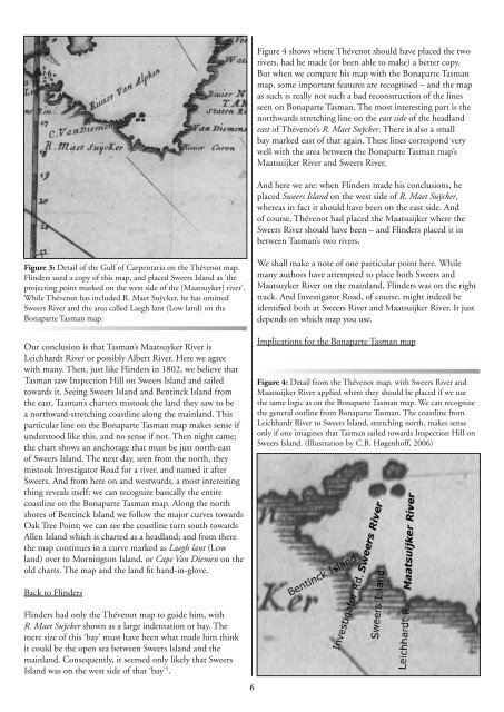
Figure 4 shows where Thévenot should have placed the tworivers, had he made (or been able to make) a better copy.But when we compare his map with the Bonaparte Tasmanmap, some important features are recognised – and the mapas such is really not such a bad reconstruction of the linesseen on Bonaparte Tasman. The most interesting part is thenorthwards stretching line on the east side of the headlandeast of Thévenot’s R. Maet Suÿcker. There is also a smallbay marked east of that again. These lines correspond verywell with the area between the Bonaparte Tasman map’sMaatsuijker River and Sweers River.And here we are: when Flinders made his conclusions, heplaced Sweers Island on the west side of R. Maet Suÿcker,whereas in fact it should have been on the east side. Andof course, Thévenot had placed the Maatsuijker where theSweers River should have been – and Flinders placed it inbetween Tasman’s two rivers.Figure 3: Detail of the Gulf of Carpentaria on the Thévenot map.Flinders used a copy of this map, and placed Sweers Island as ‘theprojecting point marked on the west side of the [Maatsuyker] river’.While Thévenot has included R. Maet Suÿcker, he has omittedSweers River and the area called Laegh lant (Low land) on theBonaparte Tasman map.Our conclusion is that Tasman’s Maatsuyker River isLeichhardt River or possibly Albert River. Here we agreewith many. Then, just like Flinders in 1802, we believe thatTasman saw Inspection Hill on Sweers Island and sailedtowards it. Seeing Sweers Island and Bentinck Island fromthe east, Tasman’s charters mistook the land they saw to bea northward-stretching coastline along the mainland. Thisparticular line on the Bonaparte Tasman map makes sense ifunderstood like this, and no sense if not. Then night came;the chart shows an anchorage that must be just north-eastof Sweers Island. The next day, seen from the north, theymistook Investigator Road for a river, and named it afterSweers. And from here on and westwards, a most interestingthing reveals itself: we can recognize basically the entirecoastline on the Bonaparte Tasman map. Along the northshores of Bentinck Island we follow the major curves towardsOak Tree Point; we can see the coastline turn south towardsAllen Island which is charted as a headland; and from therethe map continues in a curve marked as Laegh lant (Lowland) over to Mornington Island, or Cape Van Diemen on theold charts. The map and the land fit hand-in-glove.We shall make a note of one particular point here. Whilemany authors have attempted to place both Sweers andMaatsuyker River on the mainland, Flinders was on the righttrack. And Investigator Road, of course, might indeed beidentified both at Sweers River and Maatsuijker River. It justdepends on which map you use.Implications for the Bonaparte Tasman mapFigure 4: Detail from the Thévenot map, with Sweers River andMaatsuijker River applied where they should be placed if we usethe same logic as on the Bonaparte Tasman map. We can recognizethe general outline from Bonaparte Tasman. The coastline fromLeichhardt River to Sweers Island, stretching north, makes senseonly if one imagines that Tasman sailed towards Inspection Hill onSweers Island. (Illustration by C.B. Høgenhoff, <strong>2006</strong>)Back to FlindersFlinders had only the Thévenot map to guide him, withR. Maet Suÿcker shown as a large indentation or bay. Themere size of this ‘bay’ must have been what made him thinkit could be the open sea between Sweers Island and themainland. Consequently, it seemed only likely that SweersIsland was on the west side of that ‘bay’ 5 .
in 1941. Grahame Anderson sheds light on the map’s ageand origin, and when presented with a draft version of SweersIslands Unveiled in January this year, Mr. Paul Brunton,Senior Curator at the Mitchell Library in Sydney, saw theimplications our analysis had on the Bonaparte Tasmanmap. ‘It sheds fresh light on this map and its significanceand on the quality of the charting of that 1644 voyage’, hewrote in the foreword. Needless to say, for amateur historianslike Lyn and Tex Battle, Bob Forsyth, Annette Sweerts andmyself, having Paul Brunton write the foreword brought anunexpected dimension to our book. But despite this, thebook remains a personal tribute to Salomon Sweers, uncleand guardian of my ancestor Judith.Figure 5: Four 17 th -century maps superimposed. We see how theoutline of the 1645/46 Blaeu map is quite close to the BonaparteTasman map, while Thévenot (1663) and Visscher (1657) bothshow differences possibly brought on in the copying process overthe years. But like Thévenot, Blaeu had Maatsuijker River placedwhere Sweers River is on the Bonaparte Tasman map, and didnot include Sweers River. Visscher included both rivers in 1657.(Illustration by C.B. Høgenhoff, <strong>2006</strong>)The new information I mean to bring to the table now, ishow one can trace a ‘transfer of nomenclature’ from one riverto another, and how understanding the Bonaparte Tasmanmap can aid us in correcting Thévenot 1663 and Blaeu1645/46. If nothing else, this indicates that both artworkand nomenclature on the Bonaparte Tasman map is closer toTasman’s original charts. In a broader perspective, it might beyet another piece in the puzzle that will bring the BonaparteTasman map to the forefront of early Australian maps.And if Matthew Flinders should have sailed one river too farbecause of an incorrect copy made later in the 17th century,he still placed Sweers Island on the best possible spot: next toTasman’s Sweers River.Melchisedech Thévenot’s 1663 travel anthology wasimportant as it made Dutch discoveries up to 1644 knownto the wider public for the first time. The mapping of theAustralian continent on these 17th-century maps wouldremain unchanged and recognisable until the voyages ofCaptain James Cook more than a century later. There areof course other maps, among which Joan Blaeu’s ‘updated’world map published in Amsterdam in 1645/46 is theearliest. It includes Tasman’s then very recent discoveries, andcharts the areas discussed here basically as on the BonaparteTasman map, but without Sweers River. Yet other ones showa more or less twisted coastline in that same area, revealingsome degeneration in the copying process. We see this in theoutlines from the four maps I have super-imposed in Figure5 – the two debated here plus Blaeu’s 1645/46 map andNicolaas Visscher’s Indiæ Orientalis from Jan Janszoon’s NovusAtlas 1657/58. This article is not the place for a full ‘CapeVan Diemen and Sweers River’ comparison between variousmaps, but such an investigation would be interesting.The Bonaparte Tasman map was in unknown private handsbefore surfacing in 1860 when Jacob Swart published alithographic copy with transcribed, Latin lettering. Jan ErnstHeeres, the great biographer of Tasman’s life, was aware ofthe original Bonaparte Tasman map but had no access toit, and only since the 1930s has it been known to a wideraudience. A reproduction of the Swart version was laid out inmosaic on the stone floor in the Mitchell Library’s vestibuleCarsten Berg Høgenhoff, OsloNotes and references:1Carsten Berg Høgenhoff:, Sweers Islands Unveiled. Writtenin cooperation with Lyn & Tex Battle, Bob Forsyth andAnnette Sweerts. Published by Høgenhoff Forlag, Oslo,<strong>2006</strong>, ISBN 8299714028. See also http://siec.winnem.comand http://www.sweers.com.au.2Melchisedech Thévenot (1620–1692), Hollandia Novadetecta 1644, Terre Australe decouuerte l’an 1644. Engraving50 x 37 cm. Printed by Jaques Langlois, Paris, 1663.3Matthew Flinders, 1: A voyage to Terra Australis (twovolumes), G. & W. Nicol (London 1814). Reprinted bythe Libraries Board of South Australia, Australia FacsimileEditions # 37 (1966); 2: Journals of the Investigator 1801,1802 & 1803 (three volumes). First two volumes: www.sl.nsw.gov.au/flinders/manuscripts/3.html; third volume:Public Record Office, London.4Grahame Anderson, The Merchant of the Zeehaen: IsaacGilsemans and the Voyages of Abel Tasman, Te Papa Press(2001), ISBN 0909010757.5In Sweers Islands Unveiled, we refer to Flinders’understanding of the Thévenot map, but do not addressthe questions raised in this article. It was only after thebook had been printed that I saw that Thévenot must havehad the Maatsujker River placed in the wrong place.