
You also want an ePaper? Increase the reach of your titles
YUMPU automatically turns print PDFs into web optimized ePapers that Google loves.
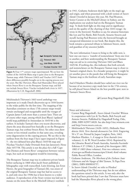
in 1941. Grahame Anderson sheds light on the map’s ageand origin, and when presented with a draft version of SweersIslands Unveiled in January this year, Mr. Paul Brunton,Senior Curator at the Mitchell Library in Sydney, saw theimplications our analysis had on the Bonaparte Tasmanmap. ‘It sheds fresh light on this map and its significanceand on the quality of the charting of that 1644 voyage’, hewrote in the foreword. Needless to say, for amateur historianslike Lyn and Tex Battle, Bob Forsyth, Annette Sweerts andmyself, having Paul Brunton write the foreword brought anunexpected dimension to our book. But despite this, thebook remains a personal tribute to Salomon Sweers, uncleand guardian of my ancestor Judith.Figure 5: Four 17 th -century maps superimposed. We see how theoutline of the 1645/46 Blaeu map is quite close to the BonaparteTasman map, while Thévenot (1663) and Visscher (1657) bothshow differences possibly brought on in the copying process overthe years. But like Thévenot, Blaeu had Maatsuijker River placedwhere Sweers River is on the Bonaparte Tasman map, and didnot include Sweers River. Visscher included both rivers in 1657.(Illustration by C.B. Høgenhoff, <strong>2006</strong>)The new information I mean to bring to the table now, ishow one can trace a ‘transfer of nomenclature’ from one riverto another, and how understanding the Bonaparte Tasmanmap can aid us in correcting Thévenot 1663 and Blaeu1645/46. If nothing else, this indicates that both artworkand nomenclature on the Bonaparte Tasman map is closer toTasman’s original charts. In a broader perspective, it might beyet another piece in the puzzle that will bring the BonaparteTasman map to the forefront of early Australian maps.And if Matthew Flinders should have sailed one river too farbecause of an incorrect copy made later in the 17th century,he still placed Sweers Island on the best possible spot: next toTasman’s Sweers River.Melchisedech Thévenot’s 1663 travel anthology wasimportant as it made Dutch discoveries up to 1644 knownto the wider public for the first time. The mapping of theAustralian continent on these 17th-century maps wouldremain unchanged and recognisable until the voyages ofCaptain James Cook more than a century later. There areof course other maps, among which Joan Blaeu’s ‘updated’world map published in Amsterdam in 1645/46 is theearliest. It includes Tasman’s then very recent discoveries, andcharts the areas discussed here basically as on the BonaparteTasman map, but without Sweers River. Yet other ones showa more or less twisted coastline in that same area, revealingsome degeneration in the copying process. We see this in theoutlines from the four maps I have super-imposed in Figure5 – the two debated here plus Blaeu’s 1645/46 map andNicolaas Visscher’s Indiæ Orientalis from Jan Janszoon’s NovusAtlas 1657/58. This article is not the place for a full ‘CapeVan Diemen and Sweers River’ comparison between variousmaps, but such an investigation would be interesting.The Bonaparte Tasman map was in unknown private handsbefore surfacing in 1860 when Jacob Swart published alithographic copy with transcribed, Latin lettering. Jan ErnstHeeres, the great biographer of Tasman’s life, was aware ofthe original Bonaparte Tasman map but had no access toit, and only since the 1930s has it been known to a wideraudience. A reproduction of the Swart version was laid out inmosaic on the stone floor in the Mitchell Library’s vestibuleCarsten Berg Høgenhoff, OsloNotes and references:1Carsten Berg Høgenhoff:, Sweers Islands Unveiled. Writtenin cooperation with Lyn & Tex Battle, Bob Forsyth andAnnette Sweerts. Published by Høgenhoff Forlag, Oslo,<strong>2006</strong>, ISBN 8299714028. See also http://siec.winnem.comand http://www.sweers.com.au.2Melchisedech Thévenot (1620–1692), Hollandia Novadetecta 1644, Terre Australe decouuerte l’an 1644. Engraving50 x 37 cm. Printed by Jaques Langlois, Paris, 1663.3Matthew Flinders, 1: A voyage to Terra Australis (twovolumes), G. & W. Nicol (London 1814). Reprinted bythe Libraries Board of South Australia, Australia FacsimileEditions # 37 (1966); 2: Journals of the Investigator 1801,1802 & 1803 (three volumes). First two volumes: www.sl.nsw.gov.au/flinders/manuscripts/3.html; third volume:Public Record Office, London.4Grahame Anderson, The Merchant of the Zeehaen: IsaacGilsemans and the Voyages of Abel Tasman, Te Papa Press(2001), ISBN 0909010757.5In Sweers Islands Unveiled, we refer to Flinders’understanding of the Thévenot map, but do not addressthe questions raised in this article. It was only after thebook had been printed that I saw that Thévenot must havehad the Maatsujker River placed in the wrong place.