The identification of environmental attributes, geographical areas <strong>and</strong> activities, as well asenvironmental attributes <strong>and</strong> geographical areas for off-road recreational drivingPurpose: To simplify procedures <strong>and</strong> safeguard sensitiveareas by identifying environmental attributes, areas <strong>and</strong>activities.OverviewSection 24(2)(b) of NEMA makes provision for theidentification of sensitive geographical areas in whichspecified activities would require an environmentalauthorisation in terms of the EIA regulations. Theidentification of such areas has to be based on theenvironmental attributes of the area, which means thatdifferent types of geographical areas, based on differentcombinations of environmental attributes, were identified.This concept creates a matrix of identified geographicalareas based on environmental attributes that are linked tospecified activities.ProgressThe project was initiated in 2008 with the followingobjectives:• Identify sensitive environmental attributes (examples ofattributes that were used to identify the geographicalareas, including threatened ecosystems, indigenousforests, important topographical features, worldheritage sites, national <strong>and</strong> provincial parks <strong>and</strong>reserves, <strong>and</strong> important wetl<strong>and</strong>s).• Identify sensitive areas based on these attributes(17 geographical areas with a unique set of specifiedactivities were identified).• Identify activities additional to the existing NEMA EIAregulations: activities that require environmentalauthorisation in the identified sensitive areas, suchas the construction of billboards, masts, tourismfacilities, roads <strong>and</strong> tracks, <strong>and</strong> aquaculture facilities(these activities vary according to the specific uniquecharacteristics of each area, such as a uniquetopographical feature).The project was concluded in 2009. The end product<strong>and</strong> methodology are used in a similar process to identifysensitive geographical areas <strong>and</strong> activities at provinciallevel.BenefitsThe project will ensure that sensitive geographical areasare identified, resulting in a proactive approach to <strong>impact</strong><strong>management</strong>, the identification of development activities16that may have a significant detrimental environmental<strong>impact</strong> in sensitive geographical areas <strong>and</strong> a reductionof the current number of listed activities that requireenvironmental authorisation in areas that can be regardedas non-sensitive to a particular activity.Possible further workThe geographical areas identified in Listing Notice 3 shouldbe captured in a GIS format for easy access by potentialapplicants to:• determine whether their proposed activity requires anenvironmental authorisation;• see why the particular area was declared a sensitivegeographical area; <strong>and</strong>• determine what other plans, such as conservationplans, EMFs <strong>and</strong> policies, are applicable to the specificarea <strong>and</strong> must be considered in the application.
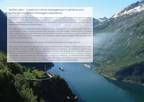
Spatial data – a basis for nature <strong>management</strong> in sensitive <strong>and</strong>protected areas: the Norwegian experienceDuring the reciprocal visits, presentations were made of two of the Directorate for Nature Management’s spatialdata systems. Spatial data is a basis for the <strong>management</strong> of resources at local, provincial <strong>and</strong> national levels <strong>and</strong>provides important <strong>and</strong> necessary input to the <strong>planning</strong> processes. Data on state-of-the-art trends is also basic inestablishing <strong>and</strong> revising environmental policy.The nature database is an expert data system designed for nature <strong>management</strong>. It contains geographic informationon a wide range of topics, including protected areas, biodiversity (important habitats, migration routes <strong>and</strong> feedingareas), publicly owned recreation areas <strong>and</strong> important cultural l<strong>and</strong>scapes. It is based on a central database withlocal map modules <strong>and</strong> is used in connection with ArcView as a GIS tool. Regional environmental authorities haveaccess to <strong>and</strong> update the base.The nature database is user-friendly with access to the Internet <strong>and</strong> has become a widely used tool.Areas without major infrastructure development in <strong>Norway</strong> (INON) is another database, showing l<strong>and</strong> areas locatedone kilometre or more (in a straight line) from major infrastructure developments. The database is updated everyfive years, thus monitoring the state of wilderness-like areas in <strong>Norway</strong>. It also shows the sectors responsible for eachparticular loss of such areas. The main idea behind INON mapping is to strengthen the basis for decision-making bymunicipalities, regional administrations <strong>and</strong> state level <strong>management</strong>. Additionally, the mapping should contributeto increased knowledge about the l<strong>and</strong> use situation, make responsible those productive sectors that carry out thedevelopments <strong>and</strong> produce the basis for environmental revision in the same productive sectors.17