Upper Windmill Street - Gravesham Borough Council
Upper Windmill Street - Gravesham Borough Council
Upper Windmill Street - Gravesham Borough Council
- No tags were found...

Create successful ePaper yourself
Turn your PDF publications into a flip-book with our unique Google optimized e-Paper software.
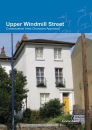
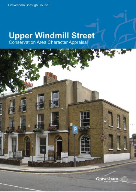
<strong>Gravesham</strong> <strong>Borough</strong> <strong>Council</strong><strong>Upper</strong> <strong>Windmill</strong> <strong>Street</strong>Conservation Area Character Appraisal
Cover: <strong>Windmill</strong> <strong>Street</strong>, <strong>Upper</strong> <strong>Windmill</strong> <strong>Street</strong> Conservation Area, Gravesend
Conservation Area Appraisal 2009<strong>Upper</strong> <strong>Windmill</strong> <strong>Street</strong>Conservation Area AppraisalThis document was prepared on behalf of <strong>Gravesham</strong> <strong>Borough</strong> <strong>Council</strong> based on an extensivesurvey dated 2007 by:The Conservation Studio1 Querns LaneCirencesterGloucestershireGL7 1RLTel: 01285 642428Email: info@theconservationstudio.co.ukwww.theconservationstudio.co.ukPublished by <strong>Gravesham</strong> <strong>Borough</strong> <strong>Council</strong> 2009
<strong>Upper</strong> <strong>Windmill</strong> <strong>Street</strong> Conservation Area 2009CONTENTS1 Statement of Special Interest of the Conservation Area 12 The <strong>Upper</strong> <strong>Windmill</strong> <strong>Street</strong> Conservation Area 22.1 Background2.2 Purpose of the appraisal2.3 Planning policy context2.4 Community Involvement3 Location and Landscape Setting 53.1 Geographic location3.2 Activities and uses3.3 Topography3.4 Geology and Biodiversity3.5 Relationship of the Conservation Area to its surroundings4 Historical Development 84.1 Archaeology4.2 Historical development5 Spatial Analysis 135.1 Layout and spaces5.2 Relationship of buildings to spaces5.3 Landmarks, focal points and views5.4 Trees, boundaries and planting6 <strong>Street</strong>scape 166.1 Public Realm7 The buildings of the conservation area 187.1 Building types7.2 Building form7.3 Listed buildings7.4 Locally listed buildings7.5 Key unlisted buildings7.6 Building Materials7.7 Local Details
<strong>Upper</strong> <strong>Windmill</strong> <strong>Street</strong> Conservation Area 20098 Character Analysis 228.1 Summary of Character areas8.2 Character area 1: <strong>Windmill</strong> <strong>Street</strong> and Stone <strong>Street</strong> (thecommercial area)8.3 Character area 2: <strong>Windmill</strong> <strong>Street</strong> (residential)8.4 Character area 3: Zion Place, Sheppy Place and Victoria Avenue8.5 Character area 4: Wrotham Road8.6 Character area 5: The Civic Area9 Issues 309.1 Definition of issues9.2 Conservation area boundary review9.3 Education and information9.4 Alterations to buildings9.5 Locally listed buildings9.6 Enforcement9.7 Parking9.8 Boundary walls9.9 EnhancementAppendices 32Appendix 1Appendix 2History of GravesendTownscape Appraisal MapAge of buildings MapDesignations MapConservation Area Boundary Map 2009
<strong>Upper</strong> <strong>Windmill</strong> <strong>Street</strong> Conservation Area 20091. STATEMENT OF THE SPECIALINTEREST OF THE CONSERVATION AREAThe <strong>Upper</strong> <strong>Windmill</strong> <strong>Street</strong> ConservationArea lies to the south of the historic centreof Gravesend. <strong>Windmill</strong> <strong>Street</strong> links directlythrough to the High <strong>Street</strong> and Town Pierin the north, and became the principalthoroughfare for visitors arriving to the town bysteam boat in the 19 th century and proceedingto the resort attractions on <strong>Windmill</strong> Hill. TheConservation Area contains part of WrothamRoad, created as a turnpike road in 1825,and Stone <strong>Street</strong>. Some small side streets,such as Zion Place, are also included in thedesignation.The buildings which line the streets containedwithin the Conservation Area were principallylaid out during the first half of the 19 th century,many of which are to the design of a localarchitect or builder. For example the pairedvillas on Sheppy Place were constructedby the builder William Wood to house hisworkmen. The buildings are typically of two,three and four storeys in height, some ofwhich are raised above a basement. Theyare characterised by the use of stock brick,stucco and sash windows, with underlying orovert references to the Classical style. Nondomestic structures were erected to serve theneeds of the growing population, such as theEmmanuel Baptist Church, and the touristsarriving in the town, such as Tulley’s Bazaar,now Milton Hall.through the Conservation Area, around ZionPlace and Sheppy Place.At the centre of the Conservation Area liethree 20 th century civic buildings. Thesewere built on land cleared of early 19 thcentury houses, and while the scale andmaterials of the buildings is in contrast tothe historic townscape, streets through thearea, Woodville Place and Zion Place, allowa degree of visual permeability through toneighbouring streets and important landmarkstructures. The Civic Centre forecourt lends tothe spacious character at the northern end of<strong>Windmill</strong> <strong>Street</strong>, where the street widens outonto Woodville Gardens. Here, mature treesand planted beds and containers soften thehard urban form and the impact of the busytraffic routes at this point.1The topography also contributes to thecharacter of the Conservation Area; the landrises gradually along the length of <strong>Windmill</strong><strong>Street</strong> to <strong>Windmill</strong> Hill in the south. Viewssouthwards along <strong>Windmill</strong> <strong>Street</strong> encompassan aspect of terraces and villas gentlyclimbing up the slopes of the hill. Changes intopography also contribute to the clear views
<strong>Upper</strong> <strong>Windmill</strong> <strong>Street</strong> Conservation Area 200922. INTRODUCTION2.1 The <strong>Upper</strong> <strong>Windmill</strong> <strong>Street</strong> ConservationAreaThe <strong>Upper</strong> <strong>Windmill</strong> <strong>Street</strong>, GravesendConservation Area was designated on 16 thJanuary 1970 by Kent County <strong>Council</strong>. TheConservation Area’s boundary containsthe northern stretch of <strong>Windmill</strong> <strong>Street</strong>, thehistoric thoroughfare between the river and<strong>Windmill</strong> Hill. Running parallel to <strong>Windmill</strong><strong>Street</strong> a section of Stone <strong>Street</strong> and WrothamRoad define the conservation area’s westernboundary. A number of secondary roadsbranch of these two linear spine roads, suchas Zion Place, South <strong>Street</strong> and North <strong>Street</strong>.The east-west tracks of the railway terminatethe conservation area’s northern end.Included within the Conservation Area arethe Civic Centre and Woodville Halls, andGravesend Police Station.2.2 Purpose of the appraisalThis conservation area appraisal has beenwritten by The Conservation Studio onbehalf of <strong>Gravesham</strong> <strong>Borough</strong> <strong>Council</strong>. Itwas prepared in September 2007 andwas followed by a process of communityengagement, which informed the content ofthis document. This appraisal defines thespecial architectural and historic interest forwhich the <strong>Upper</strong> <strong>Windmill</strong> <strong>Street</strong> ConservationArea merits designation. It identifies thepositive features that should be protected andhighlights the negative factors that detractfrom its character and appearance. It will beused by the <strong>Borough</strong> <strong>Council</strong> in consideringproposals for demolition or alteration ofbuildings, as well as for new developments. Itwill also help property owners and developersto take account of the importance of buildings,features, spaces and landscape within andadjacent to the Conservation Area.This conservation area character appraisal,and those for seven other conservation areasin Gravesend, will lead to a ManagementPlan, setting out policies and actionsto conserve and enhance their specialarchitectural and historic interest and tomitigate the effects of negative features.The appraisals and Management Plansare to be included as background papersin the emerging Local DevelopmentFramework (LDF) and, as such, will be adue consideration in the planning process. Indue course the appraisals and managementplans may also be adopted as separateSupplementary Planning Documents withinthe LDF.Preparation of the appraisal involved anextensive survey of the conservation areaundertaken in July 2007. The omission of anyparticular feature does not imply that it is of nosignificance.2.3 Planning policy contextConservation Areas are defined as ‘areas ofarchitectural or historic interest the characteror appearance of which it is desirable topreserve or enhance’ in the Planning (ListedBuildings and Conservation Areas) Act1990 (The Act). Local Planning Authoritiesare required by the Act to identify the partsof their area that should be designated asconservation areas and to formulate andpublish proposals to preserve or enhancethem. Local authorities must submitproposals for the protection and enhancementof conservation areas for consideration at apublic meeting within the relevant area. Theymust also have regard to any views expressedby people attending the meeting.
<strong>Upper</strong> <strong>Windmill</strong> <strong>Street</strong> Conservation Area 20093Broadly, the effects of designation are:• Conservation Area Consent mustbe obtained from the local planningauthority or Secretary of State prior tothe substantial or total demolition of anybuilding or structure within a conservationarea, with some exceptions;• The local planning authority mustconsider the desirability of preserving orenhancing the character or appearanceof the conservation area when assessingapplications for change in conservationareas;• Permitted development rights are slightlydifferent in conservation areas;• Permission is required from the planningauthority to fell or lop a tree over a certainsize.Further, more detailed information is providedin the Management Plan.As well as receiving statutory protection,conservation areas are protected by regional,county and local planning policies. Relevantpolicies include:• Regional Planning Guidance for theSouth East (RPG9) (published March2001), Key Development Principle No.9;Policy Q2; Policy Q5; Policy Q7; PolicyE1.• Regional Planning Guidance 9a: TheThames Gateway Planning Framework(1995), Paras. 5.4.7 & 5.4.8: BuiltHeritage, Annex 1: Planning FrameworkPrinciples No.13.• Draft South East Plan (Regional SpatialStrategy) (submitted to Governmenton 31 st March 2006), Section D8Management of the Built and HistoricEnvironment: Policy BE1; Policy BE2;Policy BE7; Section E4 (Kent ThamesGateway).• The Kent and Medway Structure Plan(adopted 6 th July 2006), Policy QL1:Quality of Development and Design;Policy QL6: Conservation Areas; PolicyQL7: Archaeological Sites; Policy QL8:Buildings of Architectural or HistoricImportance; Policy QL9: HistoricLandscape Features; Policy QL10:Heritage Assets – Enabling Development.• <strong>Gravesham</strong> Local Plan First Review(adopted November 1994), Policy TC0,TC1, TC2, TC3, TC4, TC5, TC6, TC7,TC8, TC9, TC10, TC11, TC12, Policy R3,Proposal PM13, Policy AP3.Thames GatewayIn addition to the various conservation areasin the town, Gravesend is recognised as beingin a Growth Area within the Kent ThamesGateway Sub-region by the Draft South EastPlan of the South East Regional Assembly.The various policy documents outlinedabove have, since RPG9 (1994), recognised<strong>Gravesham</strong> and Gravesend’s importantplace in the Thames Gateway (incorporatingthe former East Thames Corridor). RPG9aemphasizes the importance of <strong>Gravesham</strong>in achieving the Thames Gateway’soverall vision (para. 6.8.1) and that futuredevelopment of industrial sites should “avoidadverse impacts on the historic townscape ofGravesend town centre and its relationshipwith the River Thames” (para. 6.8.14).The Thames Gateway is an overarchingterm for the regeneration of large parts ofEast London and parts of Essex and Kent,including Gravesend. It was first embarked onas a major planning concept in the 1980s andhas developed at various stages since then.The Thames Gateway London Partnershipestimates that the expected investment in the
<strong>Upper</strong> <strong>Windmill</strong> <strong>Street</strong> Conservation Area 2009whole region will provide 150,000 jobs and200,000 homes over the next 10 years. Thelarge scale of this scheme will see a greatdeal of change across the area, includingthe introduction of new large scale transportinfrastructure such as the Channel TunnelRail link (with a proposed connection toGravesend) and major road building schemessuch as the widening of the A2 south of thetown.The policies included in the local and regionalguidance as outlined above seek to guidethis period of change and the specifiedpolicies all recognise the importance ofretaining the built as well as natural heritageof Gravesend. This document identifies thespecial character of Gravesend’s built heritageand the accompanying Management Plan willpropose how that special character can bestbe preserved and enhanced in the light of thelarge scale changes that are currently takingplace in the area.principal and desired outcomes of appraisalsand management plans and led into a generaldiscussion. The meeting was attendedby various representatives of the <strong>Borough</strong><strong>Council</strong> and local interest groups.Following the meeting, the outcomes werediscussed by <strong>Gravesham</strong> <strong>Borough</strong> <strong>Council</strong>and The Conservation Studio. Subsequently,a four week period of full public consultationwas held after which revisions were made toarrive at this final agreed document. A PublicConsultation report is attached as Appendix 3to this document for information.2.4 Community involvementThe survey of the Conservation Area hasincluded a process of public consultation toidentify the following:• The special characteristics of <strong>Upper</strong><strong>Windmill</strong> <strong>Street</strong> Conservation Area;• The key negative features and issues;• A range of possible actions that wouldmitigate or offset these detractors.4The consultation began with the notificationof key stakeholders in Gravesend at thebeginning of the appraisal process. It wasfollowed by the distribution to every propertyin the conservation areas of an invitation to apublic meeting held on 5 th September 2007.Leaflets were also displayed in public places.The meeting included a description of the
<strong>Upper</strong> <strong>Windmill</strong> <strong>Street</strong> Conservation Area 200953. LOCATION AND LANDSCAPE SETTING3.1 LocationGravesend is the administrative capital ofthe <strong>Borough</strong> of <strong>Gravesham</strong>, which contains25,000 acres of countryside and is generallyrural in appearance, containing a numberof attractive historic villages. The townlies in north-west Kent, 40 kilometres tothe east of central London. Canterbury isapproximately 65 kilometres further along theThames estuary coastline to the southeastand the major A2 and M2 trunk roads linkthe settlements. Due to the major transportinfrastructure in the area, including the M25,M20 and the rail link to the Channel Tunnel,Gravesend is very well connected to otherparts of the country and beyond.The Oxford Archaeological Unit’s KentHistoric Landscape Characterisation (2001),commissioned by Kent County <strong>Council</strong>and English Heritage, and notes that: “Theprocess of 19 th and 20 th century urbanisationis particularly marked in the northern areasof Kent”. The Dartford and <strong>Gravesham</strong>Conurbation is characterised as “a welldefined urban conurbation with some limitedmarshland and horticulture along its edges”.The <strong>Upper</strong> <strong>Windmill</strong> <strong>Street</strong> ConservationArea lies on the edge of the historic town ofGravesend. The area developed along oneof the principal arterial routes into the town,<strong>Windmill</strong> <strong>Street</strong>, through the 19 th century. Thearea also includes part of Wrotham Road andStone <strong>Street</strong>.3.2 Activities and usesThe <strong>Upper</strong> <strong>Windmill</strong> <strong>Street</strong> ConservationArea contains the administrative core of theborough, the Civic Centre. The building,and the attached Woodville Halls Theatre,addresses a large public forecourt to thenorth, on which flags and banners are located.While the forecourt provides an importantopen space in the town, the lack of attractivelandscaping makes it an uninspiring area, andone which lacks a focal point or directionalemphasis for pedestrians. To the south of theCivic Centre lies Gravesend Police Station,and the offices of Cygnet House, forming agroup of large administrative buildings. Thesethree buildings have provided a magnet forsmaller offices to cluster in this part of theConservation Area, such as those at thenorthern end of Wrotham Road.The large open forecourt of the Civic Centreis balanced by Woodville Gardens to thenorth, which contains raised flowerbeds andbenches. Surrounding these open spaceson the eastern, western and northern sidesare commercial premises, serving the needsof the passing footfall between the amenitiesof Gravesend town centre, such as the CivicCentre, the station, the main commercialdistrict and the public car parks of Parrock<strong>Street</strong> and the multi-storey on Clive Road.They are principally small local businesses,some with residential accommodation on theupper floors. There are two public housesin this part of the Conservation Area: TheRailway Tavern and No. 24 Stone <strong>Street</strong>(formerly The Station Inn). There are twofurther public houses elsewhere in theConservation Area.A limited number of commercial premiseshave spread south along <strong>Windmill</strong> <strong>Street</strong>,such as the beauticians in the formerMilton Hall. The Emmanuel Baptist Churchis the only building in religious use in theConservation Area. <strong>Windmill</strong> <strong>Street</strong> becomesincreasingly residential toward <strong>Windmill</strong> Hill.Along <strong>Windmill</strong> <strong>Street</strong>, many of the large 19 th
<strong>Upper</strong> <strong>Windmill</strong> <strong>Street</strong> Conservation Area 20096century buildings are in multiple-occupancy,although there are some single dwellings.Further residential enclaves include nos. 1-9Zion Place; nos. 1-6 Victoria Avenue, and nos.2-16 Sheppy Place, and these are almost allretained in single residential use.3.3 TopographyGravesend lies on the relatively shallowslopes of the south bank of the River Thames,close to where it widens into the estuary. Theland rises gently from the riverside, levellingoff toward the southern end of High <strong>Street</strong>,but then climbing increasingly steeply alongits continuation through <strong>Windmill</strong> <strong>Street</strong>, up to<strong>Windmill</strong> Hill on the southern outskirts of thehistoric town. Further out of the town the hillycountryside of north Kent is covered in richarable land and scattered with historic hamletsand villages.<strong>Windmill</strong> <strong>Street</strong>, and the surrounding streetsare lined with tight-knit development oftypically three-storey buildings. Thesebuildings inhibit views across the widertownscape. The elevated forecourt of the CivicCentre is an exception, permitting extensiveviews westwards through a break in thebuilding line to the chimneys of the Northfleetpower station.The streets become increasing steep south ofSouth <strong>Street</strong>, permitting interesting views overthe townscape to the north, particularly fromSheppy Place.3.4 Geology and BiodiversityGravesend lies on the thick belt of chalk thatis the most famous geological trademark ofthis part of Kent. Otherwise, the geology ofKent is varied and lies on a “crumpled dome”of sedimentary rock which also lies underSussex and Surrey. The dome’s peak haseroded exposing the rocks below, while thechalk along the edge has been more resilientto erosion and formed the North Downs inKent and South Downs in Sussex The areabetween the two is the Weald, notable for itsheavy clays and sandstone outcrops.Gravesend also lies close to areas of Thanetbeds which contain clay and together withthe London Clay found on the nearby HooPeninsula to the east produced the rawmaterials for brick making. Therefore, thisarea supplied the London stock bricksthat were used for the intensive buildingprogrammes in London and Gravesend in the19 th and 20 th centuries.While chalk is also found locally it is too soft tobe used for building large structures, althoughit supplied the raw materials for lime and,later, cement. Flints, found with chalk, arealso evident in parts of Gravesend, and aresometimes used as a walling material. KentishRagstone, quarried from neighbouring areas,is also found in the architecture of the town.3.5 Relationship of the Conservation Area toits surroundingsThe immediate surroundings of theConservation Area are urban townscape.The King <strong>Street</strong> Conservation Area bordersthe north of this Conservation Area, while<strong>Windmill</strong> Hill Conservation Area borders thearea to the south.The following features form the immediatesetting of the Conservation Area:• To the east: the Parrock <strong>Street</strong> surfacecar park and a vacant plot of land soonto be developed with residential units.Also a surviving historic terrace onClarence Row, leading to an area of 20 th
<strong>Upper</strong> <strong>Windmill</strong> <strong>Street</strong> Conservation Area 2009century comprehensive redevelopmentsurrounding <strong>Gravesham</strong> Court;th• To the west: streets of 19 centuryterraced houses, within Darnley RoadConservation Area. Wrotham Road, whichcontains 19 th century terraced houses, and20 th century infill development.7
<strong>Upper</strong> <strong>Windmill</strong> <strong>Street</strong> Conservation Area 200984. HISTORICAL DEVELOPMENT4.1 ArchaeologyEvidence of prehistoric activity in and aroundGravesend is limited to individual finds ofitems such as Neolithic axe heads and IronAge coins, although there are indications fromrecent excavations at Gravesend Hospital thatthis site was close to an area of prehistoricoccupation.A number of excavations, including those atGravesend Hospital, have revealed evidenceof Roman and Saxon occupation in the area.It is likely that Gravesend has sustainedhabitation since the early part of the Romanoccupation of Britain. The most importantand extensive excavation in recent years, atnearby Springhead on the path of the newChannel Tunnel Rail Link, has uncoveredthe Roman town of Vagniacae, an Iron Agesettlement that the Romans occupied in 43AD. Hoards of Saxon coins and early Saxonpottery have also been found at variouslocations around the town.4.2 Historical developmentThe name “Gravesend” is derived from<strong>Gravesham</strong>, possibly meaning “graaf-ham”,the home of the reeve or bailiff of the Lordof the Manor. The <strong>Upper</strong> <strong>Windmill</strong> <strong>Street</strong>Conservation Area is centred around <strong>Windmill</strong><strong>Street</strong>, the dividing line between the ancientparishes of Gravesend and Milton. <strong>Windmill</strong><strong>Street</strong> was developed during the first halfof the 19 th century as the town expandedsouthwards. It was the principal approachroute for visitors to <strong>Windmill</strong> Hill, and anumber of buildings were erected to serve thistourism industry. The historical developmentof Gravesend and Milton has been coveredin detail in a variety of publications, detailsof which are included in the Bibliographyat the end of this document. A summary ofthe development of the town is included inAppendix 2.The principal features of the historicaldevelopment of the <strong>Upper</strong> <strong>Windmill</strong> <strong>Street</strong>Conservation Area are as follows:ANGLO-SAXON AND NORMAN (450 – 1200):• 798AD - Archbishop of Canterburyacquired a large landholding inNorthfleet.• Small community established next toThames centred on a landing place(“hithe”).• 1086 - Reference to the Manors of<strong>Gravesham</strong> and Meletune (Milton).MEDIEVAL (1200 – 1485):•• 1258 - Richard de Gravesende madeBishop of Lincoln. The change of namefrom <strong>Gravesham</strong> was established forthe town.• 1300 - Gravesend had grown into asmall market town via its trade on theriver and easy supply of supplies fromneighbouring agricultural land.• The town grew under various lordshipsincluding the crown, nobility andthe Cistercian Abbey of the St MaryGraces in London.• 1380 - French and Spanish warshipsattacked Gravesend. Most of the townwas destroyed. In recompense RichardII granted the people of Gravesendsole rights to ferry passengers toLondon giving rise to Gravesend’sgrowth as a maritime centre andtrading port.• Gravesend Watermen operatedopen barges, the Long Ferry, and
<strong>Upper</strong> <strong>Windmill</strong> <strong>Street</strong> Conservation Area 20099transported passengers to and fromthe Pool of London. Larger, oceangoingvessels continued out alongthe estuary to the internationaldestinations beyond.• River related occupations, including,ferrying, victualling, rope and sailmaking and boat building andrepairing, occupied the majority of thetown’s inhabitants.TUDOR AND JACOBETHAN (1485 – 1714):• 1539/ 40 - Blockhouses erected atGravesend, Tilbury, Milton and Highamto defend London from attack.• 1562 - Charter of Incorporationunited the two parishes of Milton andGravesend• 1650 - All landing stages except for thecommon bridge (Town Pier) removed.• 1709 - Gravesend to Rochester Roadcreated.GEORGIAN & REGENCY (1714 – 1837):• Throughout this period Gravesendgrew to the east, but was oftendestroyed by fires.• 1788 – ground (now WoodvilleGardens) acquired by thechurchwardens of Gravesend as aburial ground to supplement that at StGeorge’s Church.• 1797 - Gravesend population was4,000, with 700 houses in nine streets,including The Terrace.• 1815 - First regular service of pleasuresteamers from London to Gravesend.• 1825 – Wrotham Road constructed asa turnpike road.• 1828 - Gravesend and MiltonSteamboat Company formed.• 1834 - Blockhouse Fort site sold anddeveloped as Terrace Gardens.• 1835 – Tulley’s Bazaar founded as aleisure and entertainment venue on<strong>Windmill</strong> <strong>Street</strong>.• 1855 – Burial ground landscaped tobecome Woodville Gardens.• 1859 Milton Hall erected on the sire ofTulley’s Bazaar.VICTORIAN (1837-1901):• 1842 - Royal Terrace Pier opened.A promenade established along theriverfront along with more piers.• 1843 – Emmanuel Baptist Church built• 1845 - Gravesend and Rochesterrailway opened.• 1849 – Level crossing built at MiltonRoad.• 1851 - Population of Gravesend andMilton had risen to 16,633.• 1856 - Metropolitan Board of Worksscheme to discharge London sewageonto the Thames at Crossness led toend of Gravesend’s status as a resort.• 1850s to 70s – Terrace Pier used asembarkation point for Royal voyages.• 1865 – General Gordon comes toGravesend to take charge of the NewTavern Fort.• 1883- Horse drawn tramway openedbetween Northfleet and Wellington<strong>Street</strong>.• 1893 - Royal Terrace Pier restored.• 1895 – Customs pier built.20th / 21st CENTURY:• The industrialisation of the north shoreof the Thames continued into the 20 thcentury.th• In the 20 century Gravesendcontinued to grow as a small markettown with areas of light industry.
<strong>Upper</strong> <strong>Windmill</strong> <strong>Street</strong> Conservation Area 200910Much of the industry was occupiedwith producing building materials forhouses.• 1902 - Electricity installed byGravesend Town <strong>Council</strong> and electrictrams replace horse drawn trams.• 1903 – trams introduced along<strong>Windmill</strong> <strong>Street</strong>.• 1906 – Clarence House, formerly theClarence Hotel, was demolished andnos. 70-72 <strong>Windmill</strong> Hill erected;• 1914 - Parishes of Gravesend andMilton combined to form the <strong>Borough</strong>of Gravesend. Double decker busesrun along Milton Road.• 1940 – Gravesend fire stationand police headquarters erected,demolished 1973.• 1950s - A large power stationconstructed at Tilbury.• As transport links to the city improved,Gravesend became a commutersettlement.• 1965 – Cygnet House erected as thedivisional headquarters of Kent County<strong>Council</strong>.• 1968 – Civic Centre and WoodvilleHalls opened.• 1969 - Town Pier closed. Car ferrydiscontinued and passenger servicemoved to West <strong>Street</strong> Pier. The riverlost its relevance to life in the town.The commercial centre shifted fromHigh <strong>Street</strong> to New Road and King<strong>Street</strong>. Large shopping malls built inNew Road.• 1976 - New pilot station opened onRoyal Terrace Pier.• 1977 – Woodville Gardens redesignedas a garden for the blind.• 1975 - Gravesend police stationopened.• 1990s – Traffic circulation in town reorganised.King <strong>Street</strong> and New <strong>Street</strong>pedestrianised while Parrock <strong>Street</strong>,Lord <strong>Street</strong>, <strong>Windmill</strong> <strong>Street</strong> and Stone<strong>Street</strong> made part of the inner ring road,introducing high levels of traffic intothe northern part of the conservationarea.
<strong>Upper</strong> <strong>Windmill</strong> <strong>Street</strong> Conservation Area 20091843 - 931843-9311
<strong>Upper</strong> <strong>Windmill</strong> <strong>Street</strong> Conservation Area 20091891 - 19121891-1912125. SPATIAL ANALYS
<strong>Upper</strong> <strong>Windmill</strong> <strong>Street</strong> Conservation Area 20091904 - 391904-3913
<strong>Upper</strong> <strong>Windmill</strong> <strong>Street</strong> Conservation Area 20091919 - 43<strong>Upper</strong> <strong>Windmill</strong> <strong>Street</strong>, 1919-430 25 50 100 Meters14(c) Crown copyright. All rights reserved. <strong>Gravesham</strong> <strong>Borough</strong> <strong>Council</strong> Licence 100019166/09
<strong>Upper</strong> <strong>Windmill</strong> <strong>Street</strong> Conservation Area 2009155. SPATIAL ANALYSIS5.1 Layout and spaces<strong>Windmill</strong> <strong>Street</strong> was not developed until the19 th century, although the route had existedprior to this as an historic route into the townfrom the London to Rochester Road. WrothamRoad was created as a turnpike road in 1825.Both routes were developed with speculativehousing as the town expanded southwards.Terraced houses and paired villas line thestreets, many of which are set back from thepavement behind front gardens.<strong>Windmill</strong> <strong>Street</strong> widens out at its northernend, linking to the public open space ofWoodville Gardens, and Stone <strong>Street</strong>. Herethe pavements are wider, the result of theremoval of front garden areas to createforecourts in front of commercial premises.Large scale clearance of early 19 th centuryhouses to provide a site for the Civic Centreand Woodville Halls has created a break inthe traditional layout of streets, houses, andfront gardens. The Civic Centre fronts a largeforecourt to the north. While the two otherlarge 20 th century buildings, the police stationand Cygnet House, are surrounded by carparks.5.2 Relationship of Buildings to SpacesIn the <strong>Upper</strong> <strong>Windmill</strong> <strong>Street</strong> ConservationArea almost all of the buildings are set backfrom the public thoroughfares behind frontareas and gardens, thereby enhancing thewide, open character of the roads. In certainstretches the front gardens have beenlost, particularly in front of the commercialpremises on the east side of <strong>Windmill</strong><strong>Street</strong>, from the junction with North <strong>Street</strong>to the railway line in the north. Public realmimprovements have introduced bollards tothese areas to prevent car parking. Thesewide, spacious pavements are a characteristicof this part of the Conservation Area and arevital to create distance between pedestriansand the busy traffic intersection of <strong>Windmill</strong><strong>Street</strong> and Wrotham Road.Where front areas and gardens are retained,the space is predominantly delineated bytraditional cast-iron railings set into stoneplinths or rendered brick walls. The frontgardens and their boundaries play animportant role in separating public fromprivate space, but more importantly createan appropriate setting for the buildings. Insome instances stylistic characteristics ofthe principal building are introduced, suchas corresponding ironwork detail betweenrailings and balconies. At the southern endof the Conservation Area there are a fewbuildings notable for the size of the plot inwhich they are set; the plot sizes generallyaccord with the scale of the building andprovide necessary ‘breathing space’. Keyexamples are no. 17 Sheppy Place and nos.109-110 <strong>Windmill</strong> <strong>Street</strong>.The coherence of the building line establishedby the terraces and paired villas, set backfrom the pavement line behind front gardens,breaks down along rear plot lines and someof the side lanes. Many of the rear boundarywalls have been lost from the buildings on<strong>Windmill</strong> <strong>Street</strong>, so that the former gardencan be used for car parking, and in someinstances the entire rear garden has beenbuilt over. This loss of a strong rear plot lineand delineation between the public and theprivate realms has created a much moreopen, ragged, character to these spaces.The spaces around two of the large 20 thcentury administrative buildings, i.e. theGravesend Police Station and Cygnet House,
<strong>Upper</strong> <strong>Windmill</strong> <strong>Street</strong> Conservation Area 200916have been conceived in functional terms toprovide large areas of surface car-parking.The car parks have not been landscapedto enhance the setting of the buildings theysurround. In contrast, the forecourt to theCivic Centre has been conceived as a publicamenity space and landscaped accordingly;the car park is concealed beneath. Theforecourt is raised above the surroundingpavement level, creating a sense of grandeurand arrival on approaching the Civic Centre,and an appropriate scale of setting to thebuilt mass of the Civic Centre. The forecourtcontains some raised flowerbeds and a pond,all created from concrete. <strong>Street</strong> furniture isclustered in small groups across this vastspace, and differs from the heritage-designledfurniture in the rest of the conservationarea. However, the forecourt lacks a sense ofenclosure, in particular at the northern end,and a creative, vibrant landscape designwhich would help to mitigate the currentnegative visual impact that such a large,unbroken expanse of paving has on theConservation Area.5.3 Landmarks, focal points and viewsThe principal landmarks in the <strong>Upper</strong> <strong>Windmill</strong><strong>Street</strong>, Gravesend Conservation Area are:• The Civic Centre;• Gravesend Police Station;• Cygnet House;• The Railway Tavern;• Emmanuel Baptist Church;• Milton Hall;• Nos. 70-71 <strong>Windmill</strong> <strong>Street</strong>;• Nos. 109-110 <strong>Windmill</strong> <strong>Street</strong>;• No. 16 Wrotham Road.The scale of the Civic Centre, GravesendPolice Station and Cygnet House makethem the principal landmarks within theConservation Area. These three 20 th centurybuildings are six storeys at their highest,dwarfing the surrounding 19 th centurydevelopment.The Conservation Area is focused around thelinear route of <strong>Windmill</strong> <strong>Street</strong>. The land risesas the street progresses south up towards<strong>Windmill</strong> Hill, giving extended views northand south along the street. Looking southup <strong>Windmill</strong> <strong>Street</strong>, Tivoli House, just outsidethis Conservation Area, is set high abovethe surrounding buildings, and provides atermination point to the view.The northern end of <strong>Windmill</strong> <strong>Street</strong> widensout onto the open space of the Civic Centreforecourt and the Woodville Gardens, withshort views across this open space betweenthe terraces of <strong>Windmill</strong> <strong>Street</strong> and those onWrotham Road. The raised forecourt of theCivic Centre provides extended views northeastwardsthrough a break in the buildingline. The principal view of the Civic Centre isachieved from the forecourt.The meandering course of Wrotham Roadprovides a series of deflected views. Theseare tightly framed by the continuous domesticbuilding line on the west side of the road,and the line of trees on the east side of theroad. The Prince Albert public house sits ona prominent corner site and is a importantfeature in views along Wrotham Road. Sideroads link east-west between Wrotham Roadand <strong>Windmill</strong> <strong>Street</strong>. The Emmanuel BaptistChapel provides a strong termination pointto the view east along Zion Place. FromWrotham Road views west along the sidestreets run along rows of terraced houses,outside of the Conservation Area boundary.
<strong>Upper</strong> <strong>Windmill</strong> <strong>Street</strong> Conservation Area 2009The principal positive views are:• Southwards along <strong>Windmill</strong> <strong>Street</strong> towardTivoli House;• Views across the Civic Centre forecourtand Woodville Gardens to the buildingson Stone <strong>Street</strong> and the northern end of<strong>Windmill</strong> <strong>Street</strong>;• East along Zion Place toward theEmmanuel Baptist Church;• North from Zion Place toward SheppyPlace;• Northwards along Wrotham Road to thePrince Albert public house.sweeping lawns, flower beds and shrubs.Nos. 1-6 Victoria Avenue have imaginativelydesigned and well-kept front garden displays,which instil an atmosphere of cottage gardencharm on this secluded lane.5.5 Trees, boundaries and plantingDespite being a built-up urban area treesare an important feature of the <strong>Upper</strong><strong>Windmill</strong> <strong>Street</strong> Conservation Area. Someof the trees have been planted to enhancethe streetscene, and are concentrated atthe northern end of the Conservation Area,around Woodville Gardens, designed as agarden for the blind. Another strong line oftrees runs along the western edge of the CivicCentre and police station. The public realm atboth Woodville Gardens and the Civic Centreforecourt is enhanced by the use of raisedflower beds to define and protect the spaces.Further raised planters are located on thewide pavement to the north of The RailwayTavern.17Many of the buildings have front gardens.These are typically bounded by traditionalcast iron railings set in stone, or renderedbrick, plinths. Substantial front gardens of noteinclude nos. 109-110 <strong>Windmill</strong> <strong>Street</strong>, no. 116<strong>Windmill</strong> <strong>Street</strong>, and no. 115 <strong>Windmill</strong> <strong>Street</strong>.In the case of the later two examples thehouses are well set back from the street, onhigher ground than the neighbouring terrace,permitting clear views of their attractive
<strong>Upper</strong> <strong>Windmill</strong> <strong>Street</strong> Conservation Area 2009186. STREETSCAPE6.1 Public realmPavementsThe pavements in the <strong>Upper</strong> <strong>Windmill</strong> <strong>Street</strong>Conservation Area contain a mixture oftraditional and modern surface treatments andthe traditional relationship of raised pavementto road surface has been maintained in termsof levels.<strong>Windmill</strong> <strong>Street</strong> retains wide granite kerbsalong much of its length, although thepavements are of tarmac. Few historicsurfaces remain, an exception being the settslaid along the gutter on South <strong>Street</strong>. Where<strong>Windmill</strong> <strong>Street</strong> widens out to the north ofthe Civic Centre, there is an eclectic range ofhard-surfacing materials, much of which is laidin front of retail premises, on former domesticfront garden areas, and has become part ofthe public realm. The appearance of this area,and that in front of nos. 20-23 Stone <strong>Street</strong>could be improved if a uniform paving schemewere adopted. Part of the public footpath onStone <strong>Street</strong> is laid with red bricks, whichdoes not correlate with surrounding surfacetreatments.The forecourt of the Civic Centre is laid withtextured concrete paving slabs, with linesof stone slabs introduced to divide the largesurface area into squares and add texturalinterest. Woodville Gardens, to the south ofthe Railway Tavern was landscaped in 1977as a garden for the blind; the central area issurfaced with random stone paving betweenraised planting beds. The street surfacessurrounding the garden are tarmac, which islaid immediately up to the base of the maturetrees; such a treatment detracts from thequality of the public realm in this area.<strong>Street</strong> furniture, signage and other featuresTwo distinct styles of street furniturecharacterise the public realm in the areas tothe north of the Civic Centre. On the raisedCivic Centre forecourt itself benches andlitter bins in silver metal, are in a modernstyle. A row of flag poles fly local, nationaland international standards, while tall verticalbanners display local government slogans. Incontrast the street furniture situated along thepavements at the junction of <strong>Windmill</strong> <strong>Street</strong>and Wrotham Road is traditional in design; thebollards, railings, litter-bins and benches ofcast-metal are painted blue and embellishedwith a raised and painted Gravesend coatof arms. These armorial bearings weregranted to the borough in 1975, just priorto <strong>Gravesham</strong> <strong>Borough</strong> <strong>Council</strong> beingconstituted.<strong>Street</strong> signs are generally modern. Largedirectional highways signs proliferate at thebusy junction of <strong>Windmill</strong> <strong>Street</strong> and WrothamRoad. A few historic cast iron street signssurvive at Zion Place, Victoria Avenue andRailway Place.A double-slot post box provides an attractivefeature on the eastern side of WoodvilleGardens.<strong>Street</strong> lightingThe street lamps in the Conservation Areavary in design, but are all from the late 20 thcentury. These include tall standards with“hockey stick” style lamps in <strong>Windmill</strong> <strong>Street</strong>and Wrotham Road, and a smaller-scaleexample, which appears to be a moderninterpretation of a historic gas lamp on someof the side streets. All are set in the pavementrather than being wall mounted.
<strong>Upper</strong> <strong>Windmill</strong> <strong>Street</strong> Conservation Area 2009Pedestrian movement and footpathsPedestrians within the Conservation Areagenerally have to contend with narrowfootpaths, the sense of narrownessexacerbated by the high traffic levels along<strong>Windmill</strong> <strong>Street</strong> and Wrotham Road. At thebusy junction of these two routes, pedestrianmovement is protected and managed bykerbside railings, pedestrian crossings andtraffic islands. The pavements are wider atthe northern end of <strong>Windmill</strong> <strong>Street</strong> and onStone <strong>Street</strong>, where former front garden areasof the original domestic buildings have beenincorporated as part of the public realm; thismakes for a pleasanter experience for thevisitors to the shops in this area.the police station and Cygnet House have carparks. There is a residents-only car park tothe rear of nos. 127-130 <strong>Windmill</strong> <strong>Street</strong>.Private parking is either on-road on thequieter roads, such as Sheppy Place, but ispredominantly created off-road from formergarden spaces to the fore or rear of buildings.Many of the front gardens and boundarytreatments on Zion Place have been replacedwith vehicle parking spaces.Pavement bollards prevent cars parking onthe wide pavements in front of the commercialpremises, thereby making a much safer andpleasanter environment for pedestrians.The single footpath within the ConservationArea that does not border a roadway isVictoria Avenue, which provides a routethrough between Sheppy Place and WrothamRoad. Sheppy Place itself provides a pleasantback lane for pedestrians, with little throughvehicular traffic.Traffic and parking<strong>Windmill</strong> <strong>Street</strong> and Wrotham Road are verybusy traffic routes, forming two of the principalroutes into the town from the A2, and a part ofthe traffic circulation scheme for the town. Thejunction of Lord <strong>Street</strong> and <strong>Windmill</strong> <strong>Street</strong>has heavy traffic levels, with traffic beingbrought into the town along Parrock <strong>Street</strong>,to Lord <strong>Street</strong>. The Conservation Area isadjacent to two of the town’s large public carparks, the Parrock <strong>Street</strong> surface car park andthe multi-storey on Clive Road, which attract alarge number of vehicles to the vicinity.19There are no public car parks within theConservation Area. There is a restrictedaccess car park for the Civic Centre, and both
<strong>Upper</strong> <strong>Windmill</strong> <strong>Street</strong> Conservation Area 20097. THE BUILDINGS OF THECONSERVATION AREA7.1 Building typesThe buildings in the Conservation Area arelargely historic and predominantly date fromthe 19 th century, developing along two of thearterial routes into the town, <strong>Windmill</strong> <strong>Street</strong>and Wrotham Road.The buildings which line these two principalroutes are generally a mix of residential andcommercial buildings, comprising three- andfour-storey terraces, some with shopfrontsto the ground floor. Domestic terraces ofa smaller scale are found on Zion Placeand Victoria Avenue. The paired villa is abuilding type found in the ConservationArea in a variety of forms. Nos. 109-110 arean imposing pair of houses, united undera parapet and pediment, and with strongClassical detailing. The paired villas onSheppy Place are of a smaller scale, withClassical proportions but minimal architecturaldetailing.There are four public houses in theConservation Area, the most visually dominantbeing The Railway Tavern, despite thisbuilding sitting with its rear elevation to therest of the Conservation Area. Other buildingtypes within the Conservation Area includeMilton Hall and Emmanuel Church.The three large civic administrative buildingswithin the Conservation Area all date fromthe second half of the 20 th century. The CivicCentre is the most architecturally ambitiousof the group and addresses a contemporaryforecourt.7.2 Building formThe buildings of the <strong>Upper</strong> <strong>Windmill</strong> <strong>Street</strong>Conservation Area are predominantlyarranged as short terraces of two, three andfour storeys. Many of the buildings are setabove raised basements, with the front doorapproached up a flight of steps. In additionto the terraces, there are a number of pairedvillas. Nos. 2-9 Sheppy Place comprise fourpairs of houses of uniform design, arrangedin a terrace formation. There are occasionalinstances of a pair of houses of uniquedesign, and these introduce an element ofvariety into the streetscene and act as locallandmarks, such as nos. 109-110 <strong>Windmill</strong><strong>Street</strong> and nos. 70-71 <strong>Windmill</strong> <strong>Street</strong>.Many of the buildings are set back fromthe street behind small front garden areas,although there are a few examples of muchdeeper gardens, for example no. 116 and no.118 <strong>Windmill</strong> <strong>Street</strong>. The building line varieswith each terraced group. Nos. 8-15 WrothamRoad are ranged in stepped formation toreflect the curve of the road.The northern part of <strong>Windmill</strong> <strong>Street</strong> has acontinual terrace of buildings set at the backof the pavement line. This is the result in thegreater part of the loss of front garden areasas houses have become shops, and thepavement being widened. There is a mixtureof historic and modern shopfronts, some ofwhich are in a traditional manner.The Civic Centre, the Police Station andCygnet House are all large detachedbuildings, placed in forecourt and car parksettings, which are proportional to the scaleand massing of the buildings.20
<strong>Upper</strong> <strong>Windmill</strong> <strong>Street</strong> Conservation Area 2009217.3 Listed buildingsThere are 31 listed buildings or structuresin the <strong>Upper</strong> <strong>Windmill</strong> <strong>Street</strong>, GravesendConservation Area, all of them listed grade II.The listed buildings in the Conservation Areaare all on <strong>Windmill</strong> <strong>Street</strong>. Adjacent unlistedterraces of a similar date, or slightly later,strengthen the attractive streetscene throughmaintaining the established building line,materials, proportions and detailing.Four groups of listed buildings comprising nos.38-50, nos. 51-54, nos. 55-59. and nos. 68-69<strong>Windmill</strong> <strong>Street</strong> are of mid-19 th century date,and built from yellow stock brick giving thema cohesive appearance. The terraces are ofthree and four storeys, some raised over abasement. Most of them are set back from thepavement behind front garden areas, exceptNos. 38-43 where the historic boundarieswere removed in order to create hardstandingareas an access to the shops. Stucco is usedacross some of the ground floor levels andto create architectural detailing, such as therusticated window surrounds at nos. 51-54,imitating alternating large and small blocks ofstone.No. 70 and 71 <strong>Windmill</strong> <strong>Street</strong> are two of thegrandest buildings in the Conservation Area,both in scale and as an ambitious architecturalstatement. This mid 19 th century pair are offour storeys over a basement. The façade isarticulated by a parapet and moulded eavescornice, and a further cornice below the thirdfloor, with a central pediment supported onfour composite columns, with an anthemionmotif on the capital, through first and secondfloor levels. Doors are contained within twoprojecting porticos, each having a pair of Ioniccolumns, a pair of square Doric columns andtwo Doric pilasters. This decoration and theintricate cast iron balconies make this a focalbuilding on <strong>Windmill</strong> <strong>Street</strong>.Nos. 109 and 110 <strong>Windmill</strong> <strong>Street</strong> date fromcirca 1840, of ashlar stone, although no. 110has been painted. They are in the Classicalstyle, with a central pediment supported onfour pilasters, and a rusticated ground floor.7.4 Locally listed buildingsGovernment advice is that the preparationof a List of Locally Significant Buildings is auseful planning tool. “Locally Listed’ buildingsare valued for their contribution to the localscene, or for their local historic associations,but are not considered to be of nationalimportance, so they are usually not eligiblefor statutory listing. Policies to control themcan be included in the Local DevelopmentFramework.<strong>Gravesham</strong> <strong>Council</strong> does not currentlymaintain a formal list of locally significantbuildings (usually called the ‘Local List’)either in Gravesend or elsewhere, althoughall buildings that were identified in the 1974Listed Buildings Survey for their architecturalor historic interest, but were not awardeda listing status, have been treated as‘Buildings of Local Interest’ ever since whenconsidering planning applications. Followingthe importance the Government places inits Heritage White Paper on the compilationof Lists of Buildings of Local Interest,<strong>Gravesham</strong> <strong>Borough</strong> <strong>Council</strong>’s list will bereviewed in due course.The Management Proposals for theGravesend conservation areas contain a listof buildings which might be considered forinclusion in a Local List, once the <strong>Council</strong>have approved the criteria to be used forselection. All of them are considered to bekey unlisted buildings.
<strong>Upper</strong> <strong>Windmill</strong> <strong>Street</strong> Conservation Area 20097.5 Key unlisted buildingsA number of unlisted buildings have beenidentified as being buildings of townscapemerit. Buildings identified as having‘townscape merit’ will vary, but commonlythey will be good examples of relativelyunaltered historic buildings where their style,detailing and building materials provides thestreetscape with interest and variety. Mostimportantly, they make a positive contributionto the special interest of the conservationarea. Where a building has been heavilyaltered, and restoration would be impractical,they are excluded. Key unlisted buildingsinclude:• The majority of buildings on <strong>Windmill</strong><strong>Street</strong>, Wrotham Road and Sheppy Place• Nos. 1-9 Zion Place;• Nos. 1-6 Victoria Avenue.Government guidance in PPG15 ‘Planningand the historic environment’ advises thata general presumption exists in favourof retaining those buildings which makea positive contribution to the characteror appearance of a conservation area(paragraph 4.27). The guidance note statesthat proposals to demolish such buildingsshould be assessed against the same broadcriteria as proposals to demolish listedbuildings.roofing material is Welsh slate although manybuildings have had their roofs replaced withconcrete tiles.Gravesend was at the centre of someinnovation in construction techniques in the19 th century, including the claimed inventionof Portland cement. Many cement works andchalk pits were established in the area andtherefore there was no shortage of suppliesat this time. Many buildings within theConservation Area feature an external rendercoat or architectural details that use thismaterial. Good examples of stucco rendersinclude nos. 70-71 <strong>Windmill</strong> <strong>Street</strong> and on theEmmanuel Chapel. The Civic Centre, policestation and Cygnet House demonstrate a widerange of later 20 th century building methodsand materials. In particular the Civic Centreutilises reinforced concrete to great effect forthis Brutalist statement.Cast and wrought iron is found throughout theConservation Area, principally for front arearailings (cast iron), but also for decorativebalconies and balconettes at first and secondfloor levels (wrought iron). The metal is formedinto a variety of motifs.7.6 Building Materials22The historic buildings of <strong>Upper</strong> <strong>Windmill</strong><strong>Street</strong>, Wrotham Road, and the associatedside streets within the Conservation Areahave been built using mainly local materials,particularly red and yellow brick. Some keybuildings have employed other materials,such as the sandstone ashlar on nos. 109-110 <strong>Windmill</strong> <strong>Street</strong>. The most common
<strong>Upper</strong> <strong>Windmill</strong> <strong>Street</strong> Conservation Area 20097.7 Local detailsSome of the details on buildings in theConservation Area are particularly distinctive.These include:• The use of yellow brick, with polychromedetailing;• Front areas, many of which aresurrounded by dwarf walls and cast ironrailings;• Italianate and classical ornamental details;• Render applied to all or part of elevations,and to create architectural detailing;• Wrought iron balconies;• Sash windows, including sashes withround heads on the ground floor.23
<strong>Upper</strong> <strong>Windmill</strong> <strong>Street</strong> Conservation Area 2009248. CHARACTER AREAS8.1 Summary of Character AreasWithin the present boundaries the <strong>Upper</strong><strong>Windmill</strong> <strong>Street</strong> Conservation Area can bedivided into five Character Areas accordingto landscape, topography, historicaldevelopment, layout, building type, anduses. Positive features that contribute to thecharacter of each area, or negative featuresthat detract from it, are summarised at end ofeach section. The five Character Areas are:Character Area 1: <strong>Windmill</strong> <strong>Street</strong> and Stone<strong>Street</strong> (the commercial area);Character Area 2: <strong>Windmill</strong> <strong>Street</strong>(residential);Character Area 3: Zion Place, Sheppy Placeand Victoria Avenue;Character Area 4: Wrotham Road;Character Area 5: The Civic Area.8.2 Character Area 1: <strong>Windmill</strong> <strong>Street</strong> andStone <strong>Street</strong> (the commercial area)<strong>Windmill</strong> <strong>Street</strong> developed as one of theprincipal arterial routes into Gravesend andto the river from the old London to Rochesterroad. The linear route connected directlyto High <strong>Street</strong> and the Town Pier, runningthrough open fields, market gardens, andbrick fields to the riverside town. In the18 th century part of the route was knownas <strong>Upper</strong> High <strong>Street</strong>, and prior to 1801,when New Road was constructed, Stone<strong>Street</strong> was regarded as part of GravesendBackside (now Princes <strong>Street</strong>). With thedevelopment of Gravesend as a resort inthe 19 th century <strong>Windmill</strong> <strong>Street</strong> became theprincipal thoroughfare between the TownPier and <strong>Windmill</strong> Hill, and the town spreadincreasingly southwards.Buildings in this area date from the first half ofthe 19 th century, as do those at the southernend of <strong>Windmill</strong> <strong>Street</strong> (Character Area 2).However, the commercial use of many of thebuildings, linking with the principal commercialdistrict of the town on streets such as Princes<strong>Street</strong> and New Road, and the large civicbuildings on the west side of <strong>Windmill</strong> <strong>Street</strong>,set this character area apart from the southernend of <strong>Windmill</strong> <strong>Street</strong> which is principallyresidential buildings on both sides of thestreet.Woodville Gardens, together with theforecourt of the Civic Centre (Character Area5), provide a large amount of public openspace. The gardens, together with the widepavements create a spacious character, andallow clear views across this space to thebuildings facing over the gardens. WoodvilleGardens are the site of one of the town’sburial grounds; the land was acquired in1788 by the Vestry and churchwardens ofGravesend to supplement the graveyard of StGeorge’s Church. A few relocated tombstonessurvive grouped along the rear wall of TheRailway Tavern and provide a reminder ofthe area’s origins. The site was closed forburials in 1855 and laid out for gardens; thecurrent garden scheme was laid out in 1977as a garden for the blind, provided by theRotary Club in dedication of its 50 th Jubilee.Raised planters of red brick with metal griprails are attractively planted, and together withthe mature trees which edge the plot, help tocreate a sense of enclosure and protectionfrom the busy traffic routes which border thegarden.
<strong>Upper</strong> <strong>Windmill</strong> <strong>Street</strong> Conservation Area 200925Rows of shops face across WoodvilleGardens. Nos. 21-23 Stone <strong>Street</strong> aresome of the oldest buildings in the area,constructed in 1789 as Gravesend andMilton’s workhouse. However, the buildingshave been incorporated into a coherent block,with no. 20, and the former Station Inn publichouse, now Bar 24, behind a stucco façade,with a moulded cornice and parapet. Eclecticdetailing between each building createsinterest and variety, such as rusticated groundfloor elevations, but overall the buildings arepresented as a coherent historic group, andare an important backbone of the townscapein this area. Unfortunately modern shopsignage, boundary treatments and pavementsurface treatments undermine the historiccharacter and appearance of the terrace.The row of buildings on the east side of<strong>Windmill</strong> <strong>Street</strong>, running from the railway toLord <strong>Street</strong>, comprise two- and three storeybuildings, many of which were built as houses,but now all of which contain commercialpremises. Any former front garden areas andtheir means of enclosure have been lost;shops now sit at the back of an extra widepavement. Nos. 15-20 appear to be someof the earliest buildings in the row. The twostorey buildings form a terrace of single-baystructures; the rhythm of the bays has beenlost at ground floor level with the introductionof modern shopfronts, some of which spanacross more than one bay, but is retained atfirst floor level, where some original multipanedsash windows survive.Historic shopfronts, and new shopfronts inthe traditional manner are to be found furthersouth on <strong>Windmill</strong> <strong>Street</strong>. An interestingexample is no. 33 <strong>Windmill</strong> <strong>Street</strong> which hasa two-storey timber shopfront. An importantgroup of traditional shopfronts are found atnos. 40-42 <strong>Windmill</strong> <strong>Street</strong>, articulated withpilasters beneath a scalloped fascia board.Signage has been sympathetically designedto enhance these attractive frontages.The east side of <strong>Windmill</strong> <strong>Street</strong>, betweenLord <strong>Street</strong> and South <strong>Street</strong> contains anumber of buildings which remain intact to theoriginal residential form, without shopfrontsinserted at ground floor level. These buildingsare in a mixture of office and residential use.The majority of these buildings are grade IIlisted: nos. 38-50 (St George’s Terrace); nos.51-54; and nos. 55-59. They date from themid 19 th century and are characteristically ofyellow stock brick, of three storeys and witha stuccoed ground floor. The character ofthe streetscape alters as many more of thebuildings retain, or have had their area wallsand railings reintroduced, for example atnos. 51-54 as part of a grant under a HistoricEnvironment Regeneration Scheme.The Emmanuel Baptist Church forms animportant landmark building between theterraced rows. Built in 1843, to the designsof John Gould, with his father as builder,the rendered church is a tall two storeys,articulated by giant order pilasters. Thewhole sits beneath a plain entablature andpediment. The church and the buildings forman important streetscape group which sitscomfortably together, partly because of anunderlying system of Classical proportionsand details on each structure.The principal features of the built form are:• Urban character;• Two and three storey terraced houses;• Many buildings set at back of pavementline as the result of the destruction of frontarea boundary treatments;• Other buildings, predominantly residential,set back from the pavement behind front
<strong>Upper</strong> <strong>Windmill</strong> <strong>Street</strong> Conservation Area 200926gardens• Areas bordered by dwarf walls and castiron railings;• Terraced houses typically of two bayswide, constructed of stock brick, some ofwhich are rendered at ground floor level;• Multi-paned sliding sash windows;• Large number of grade II listed buildingson <strong>Windmill</strong> <strong>Street</strong>;• Emmanuel Baptist Church, 1843.Negative features/issues:• Loss of architectural features, such asdoors, windows;• Loss of front garden areas, boundary wallsand railings;• Variety of surface treatments used forpavements and for former front gardenareas, some of which are in a poor state ofrepair;• Accretions on the principal elevations ofbuildings, such as satellite dishes andburglar alarms;• Some of the slate roofs have beenreplaced with concrete tiles;• Modern shopfronts and signage which isnot of a design that reflects or enhancesthe historic building on which it is inserted;• Volume of traffic and congestion atintersection of <strong>Windmill</strong> <strong>Street</strong>/WrothamRoad.8.3 Character Area 2: <strong>Windmill</strong> <strong>Street</strong>(residential)This character area is focused in the sectionof <strong>Windmill</strong> <strong>Street</strong> which runs between South<strong>Street</strong> and Clarence Place. It is characterisedby terraced buildings ranged on both sidesof the street, and some paired villas, whichare arranged to create a unified group. Thebuildings are predominantly in residential use,as a mixture of single dwellings and flats.On this part of <strong>Windmill</strong> <strong>Street</strong> the land beginsto rise increasingly steeply towards <strong>Windmill</strong>Hill in the south. Views southwards along thestreet take in the groups of terraces whichclimb the gentle slope, and look towardsthe focal building of Tivoli House, outside ofthe Conservation Area boundary. All of thebuildings are set back from the pavementline behind front gardens, many of which areenclosed by walls and cast iron railings. Manyof these front gardens are attractively planted;the foliage of plants has a softening effecton the hard urban townscape. The buildingline recedes and projects with each shortterrace, creating a sense of movement to thestreetscene.Three pairs of buildings on this stretch of<strong>Windmill</strong> <strong>Street</strong> are grade II listed: nos. 68 and69; nos. 70 and 71 and nos. 109-110. Eachpair is distinct in terms of its architecturaldetailing, and often grandiose designstatement, but in scale and proportionalarrangement of the components of theelevation there is an underlying reference tothe Classical style, between these and theunlisted adjacent 19 th century terraces andpaired villas. Nos. 109-110 were known as‘North House’ and ‘South House’ and wereoriginally surrounded by cast iron railings andgate standards decorated with the town arms;these were originally part of the railings of theTown Pier.Building heights range from two to fourstoreys, and some buildings are additionallyset above a raised basement. Yellow stockbrick is the prevalent building material,rendered in part or in entirety. Nos. 77-84<strong>Windmill</strong> <strong>Street</strong> are four pairs of villas ofuniform design, although subject to variouslater alterations, such as the public house andshop built over the front gardens of nos. 77-78. Each pair of houses is two bays wide, and
<strong>Upper</strong> <strong>Windmill</strong> <strong>Street</strong> Conservation Area 200927set beneath a hipped roof with large centralstack. Sliding sash windows articulate eachbay, and the entrance door is concealedon the return. The buildings have a rendercoat, which is defined as banded rusticationat ground floor level on nos. 79-80 and nos.83-84. Nos. 83-84 also has a decorativestrapwork pattern applied in render to theelevation. The buildings feature attractivecast iron balconies and balconettes.No. 116 and no. 117 <strong>Windmill</strong> <strong>Street</strong> form anattractive pair of buildings which are visuallydistinct from the three-storey yellow brickterraces which characterise the west sideof the street. The buildings are of differentheights, with distinct architectural identities,but an underlying reference to the Classicalstyle and the use of a stucco render coatunifies the two buildings. These two housesare set back from the pavement line behindlarge front gardens; these gardens recessthis pair of buildings behind the commonbuilding line of the street. No. 117 is anarrow, two-bay three-storey house, with astucco porch articulated as flat pilasters. Therectangular fanlight above the door and thewindows feature marginal glazing. No. 116 isa two-storey three-bay building, set beneatha mansard roof. A particularly attractivefeature is the three cast iron balconiesat first floor level; each window retains adecoratively scalloped blind box.Nos. 71a and b, 72, and 72a and b, are of adifferent period and character from much of<strong>Windmill</strong> <strong>Street</strong>, which dates from the 1830sand 40s. These three buildings date from1906, and were erected on the site of thedemolished Clarence House, formerly theClarence Hotel serving visitors to the towntravelling to the resort attraction of <strong>Windmill</strong>Hill in the 19 th century. The houses arepresented as three terraced houses, but apair of entrance doors indicates that there aretwo flats internally. They appear as suburbanterraced houses, with diluted references to thevernacular style, with large chimneystacks,applied timber-framing to the gables, andterracotta crested ridge tiles and finialsdecorating the slate roofs.An important focal building in this area,distinct in both function and design, is MiltonHall. This was originally erected as a timberbuilding in 1835 as Tulley’s Bazaar, as a placeof leisure and entertainment for tourists tothe town. The existing Milton Hall was builtin 1859, and has since been a drill hall forthe Local Artillery Volunteers, and in 1890,a grocery known as Milton Hall Stores. Thebuilding has a distinctive stucco façade witha curved pediment, and corners encased inCorinthian pilasters.The principal features of the built form are:• Urban character;• Terraced houses and paired villas,arranged as small groups;• Houses set back from pavement behindfront gardens;• Use of stock brick, with stucco renderused to cover entire buildings andarchitectural detailing;• Multi-paned sliding sash windows.Negative features/issues:• Loss of original architectural features,such as windows, doors and boundaryfeatures.8.4 Character Area 3: Zion Place, SheppyPlace and Victoria AvenueThis small character area encompasses theresidential buildings of Zion Place, Victoria
<strong>Upper</strong> <strong>Windmill</strong> <strong>Street</strong> Conservation Area 200928Avenue and Sheppy Place. The area ischaracterised by two-storey buildings of thefirst half of the 19 th century, which were laidout on newly constructed roads as the townexpanded southwards during this period. Theland rises quite steeply southwards in thisarea; the terrace of nos. 1-6 Victoria Avenueare set on much higher ground than nos. 1-9Zion Place to the north. Clearance of the landfor the erection of Cygnet House (CharacterArea 5) and the surrounding large car park,together with the change in topography,permits clear views into and through thisarea. For example, the rear elevations of theterraced houses on Zion Place are visiblelooking northwards from Sheppy Place, andvice versa, the paired villas of Sheppy Placeare seen clearly stepping up the hillsidelooking southwards from Zion Place.Zion Place was originally known as Woodville<strong>Street</strong>, but was changed in the later 19 thcentury; the Baptist Zion chapel constructedopposite the eastern end of the street waserected in 1843. The houses are of twostoreys raised above a basement, andapproached up a flight of steps. The shortterrace of nine houses were built in identicalform with a rounded headed door and sashwindow at ground floor level, with two squareheadedsash windows at first floor level,and a single square-headed window at thebasement storey. Yellow brick was used forthe construction of the terrace, laid in finegauged work above the door and windows.A rendered cill band adds interest to eachfacade. The buildings are set back from thepavement line behind front garden areas,although many of the boundary walls andrailings have been demolished and thegardens used for vehicle-parking. Zion Placeis an important group of 19 th century houses,which survived the clearances in the vicinity inthe 1960s, however they have lost number ofarchitectural features which has eroded someof their architectural interest.Sheppy Place was laid out as an approach toBaynard Castle, a castellated Gothic house,formerly Lacey Castle. It was built in the early19 th century by Edward Lacey, a former mayorand was demolished in 1952. The four pairedvillas which line the west side of SheppyPlace were constructed by William Wood, thebuilder, for his workmen, and a further terracewas erected to the south of these in the lastquarter of the 19 th century. The two storeyhouses are of a simple form; each house isof a single bay with a square-headed sashwindow at each floor and with the entranceconcealed on the returning elevation.However, the arrangement of the buildings inpairs, set beneath an imposing hipped roof,with central chimneystack, increases theirvisual status in the street. The paired villasare predominantly of yellow brick, althoughsome houses have an applied render coat,applied as banded rustication at ground floorlevel. At the southern end of Sheppy Placestands no. 17, a large three-storey detachedhouse, set in extensive grounds. It is animportant landmark when viewed southwardsalong the street, but close-range views arelargely obscured by the high retaining walland mature trees which occupy the largegarden.The 19 th century terrace of six houses, rangedalong the north side of Victoria Avenue, havea parallel appearance to the villas on SheppyPlace. They are constructed of yellow brick,with render applied in the pattern of bandedrustication at ground floor level. However,the character of Victoria Avenue is quitedifferent; the buildings are set facing a narrowpedestrian footpath which links throughto Wrotham Road, and have well-tendedfront gardens, resulting in a quieter, leafier,
<strong>Upper</strong> <strong>Windmill</strong> <strong>Street</strong> Conservation Area 200929car-free, residential enclave.The principal features of the built form are:• Urban character;th• Early 19 century terraced houses andpaired villas, constructed of yellow brick;• Buildings set back from the pavement linebehind front garden areas;• Buildings have both round-headed andsquare-headed timber sash windows.Negative features/issues:• Loss of architectural features, such asdoors and windows;• Loss of front garden areas, boundary wallsand railings, to create vehicle parkingareas; this is notable on Zion Place;• Some of the brick buildings have beenrendered or painted, which disrupts thevisual continuity of the terraces;• Some of the slate roofs have beenreplaced with concrete tiles;• Loss of rear gardens to create vehicleparking areas, notably at Sheppy Place(rear of properties Nos. 119-126 <strong>Windmill</strong><strong>Street</strong>);• Under-maintained garage buildings atSheppey Place8.5 Character Area 4: Wrotham RoadThis character area comprises a short stretchof buildings on the west side of WrothamRoad, facing eastwards across to the CivicCentre and Police Station (Character Area5), connecting to Stone <strong>Street</strong> in the north(Character Area 1). The buildings, of variousdesigns, date from the last quarter of the 19 thcentury, with the exception of no. 6 which ispossibly from earlier in the century.Wrotham Road was constructed in 1825 as aturnpike road, providing a new route into thetown from the London to Rochester road. Itis a very busy route, connecting to the innerring-road, and traffic noise and fumes have adetrimental impact on the atmosphere of thestreet.Terraced houses characterise this stretch ofWrotham Road, with occasional paired orsingle houses in between. All of the buildingsare set back from the pavement behind smallfront areas surrounded by rendered dwarfwalls and cast iron railings. Nos. 8-15 and no.16 Wrotham Road comprise a unified group;an identical terrace is to be found on Darnley<strong>Street</strong>, just outside of the Conservation Area’sboundary. The area around Darnley <strong>Street</strong>was laid out by Messrs Pillow & Pollock in the1840s. The buildings are of three storeys overa raised basement, and of two bays wide.At first and second storey level sit a pair tworound headed windows and at ground andbasement level, there is a centrally placedcanted bay. Front doors are recessed fromthe principal elevation by a lobby area. Adistinctive treatment of yellow brick walls laidin Flemish Bond are enlivened by a stuccocoat to the lower two storeys and detailingto the window surrounds above, creatingpilasters and keystones. Cill bands and acornice are also articulated in stucco. Eachhouse of the terrace of nos. 8-15 WrothamRoad is set back slightly from its neighbour,creating a stepped arrangement to the rowthat reflects the curve in the road at this point.No. 16 Wrotham Road has a front to WrothamRoad, but also a front to Darnley <strong>Street</strong>,where it terminates a terrace of matchingdesign; its impressive Dutch gable providesan important landmark on the street.To the north of this terrace on WrothamRoad sits no. 7 Wrotham Road, a building ofa similar date and architectural conception,
<strong>Upper</strong> <strong>Windmill</strong> <strong>Street</strong> Conservation Area 200930but with individual design flourishes. Thebuilding is of two storeys over a raisedbasement, with centrally placed canted bayat basement and ground floor levels. Thebuilding is constructed from yellow brick, withdistinctive raised red and blue brick detailingof architectural features, such as quoins and acornice. Unfortunately this building has beenthe subject of a large box roof extension,which has undermined the well-consideredproportions of the historic building.Polychrome brickwork is found on otherbuildings in this area, for example nos. 18-24Wrotham Road. In this instance the yellowbrick has been decorated with flush redbrick bands, quoins and diamond patterns.Detailing of the double-height canted bays,including the Corinthian columns on thecorners of the bays, has been painted white.The principal features of the built form are:• Urban character;• Residential buildings dating from the lastquarter of the 19 th century;• Buildings typically of two and threestoreys;• Buildings set back from pavement behindfront areas;• Areas bounded by dwarf walls and castiron railings;• Buildings constructed of yellow brick,with detailing in stucco, and polychromebrickwork.Negative features/issues:• Volume, speed and associated noise oftraffic;• Some of the slate roofs have beenreplaced with concrete tiles• Demolition of boundary walls to create offroadvehicle parking areas has eroded theimmediate setting of historic buildings.8.6 Character Area 5: The Civic AreaThis is the principal administrative centreof Gravesend, containing the Civic Centre(offices of <strong>Gravesham</strong> <strong>Borough</strong> <strong>Council</strong>) andGravesend Police Station. Cygnet Houseis a large office block, containing somefunctions of <strong>Gravesham</strong> <strong>Borough</strong> <strong>Council</strong>.It was erected in 1965 as the divisionalheadquarters of Kent County <strong>Council</strong>. Leisurefacilities are offered by the Woodville HallsTheatre. The Civic Centre, designed by H.T. Cadbury Brown opened in 1968, whenthis part of Gravesend was comprehensivelyredeveloped.The three buildings form this character area,together with the forecourt of the Civic Centre,Woodville Place, and the car parks associatedwith the administrative buildings. The areadoes not contain any historic structures andis characterised by the three buildings fromthe second half of the 20 th century. The areais bordered to either side by the busy arterialroutes of Wrotham Road and <strong>Windmill</strong> <strong>Street</strong>.The three buildings are expressive of aparticular period in architecture, and the CivicCentre in particular makes a strong statementwith its Brutalist idiom and use of reinforcedconcrete. The raised forecourt is constructedin concrete, including the planting beds andpond, forming a contemporary but uninspiringsetting to the Civic Centre. A row of matureconifers softens the western edge of theforecourt. The forecourt’s distinct identityfrom the surrounding townscape is reinforcedby the unique design of the street furniture;the furniture includes benches and litter binsof modern design in slatted silver metal.The ensemble sits well together as a setpiececomposition, although the scale of thebuildings dominates the surrounding historic
<strong>Upper</strong> <strong>Windmill</strong> <strong>Street</strong> Conservation Area 2009built form and street pattern.While the scale and massing of the threebuildings in this character area neitherreflect nor enhance the surrounding historictownscape, the retention of streets betweenthe buildings has ensured a degree of visualpermeability. Woodville Place and ZionPlace, both allow views through this area, forexample the clear view eastwards along ZionPlace to the Emmanuel Church on <strong>Windmill</strong><strong>Street</strong>.The principal features of the built form are:• Urban character;• Three large civic buildings dating from thesecond half of the 20 th century;• Buildings clad with concrete panels;• Civic Centre has a hard-landscapedforecourt to the north;• The police station and Cygnet Houseare surrounded by hard standing and carparks;• Two narrow streets run between thebuildings, allowing a degree of visualpermeability to the surrounding historictownscape.Negative features/issues:• Volume of traffic and congestion at thenorthern end of Civic Centre forecourt;• large, unbroken expanse of paving andlack of enclosure of the Civic Centreforecourt;• The three civic buildings are of a scale,mass and materials that neither preserveno enhance the character or appearanceof the surrounding historic townscape.31
<strong>Upper</strong> <strong>Windmill</strong> <strong>Street</strong> Conservation Area 2009329. ISSUES9.1 Definition of IssuesThe following ‘Issues’ have been identified bythe appraisal process (via extensive surveywork) and have been modified to include theviews of the local community as part of thepublic consultation exercise, including a publicmeeting and four week period of consultation.They provide the basis for the Site SpecificActions in the management proposals for theeight Gravesend town centre ConservationAreas (see Gravesend Town CentreConservation Areas: Management Plan,February 2008). These issues will be subjectto regular review by the <strong>Council</strong> and new onesmay be added in the future.9.2 Conservation area boundary reviewIt is not recommended that the boundary ofthe <strong>Upper</strong> <strong>Windmill</strong> <strong>Street</strong> Conservation Areais extended, as the designation covers thespecial architectural and historic interest of<strong>Windmill</strong> <strong>Street</strong> and the surrounding area.Other areas of importance are containedwithin adjacent conservation areas.It is proposed that The Railway Tavern isremoved from this Conservation Area andadded to the King <strong>Street</strong> Conservation Area.The building faces Railway Place, and sitswith its back to the rest of the ConservationArea; the orientation of the building creates arelationship of this building with the buildingson the north side of Railway Place.9.3 Education and informationActive measures for promoting betterunderstanding of Gravesend and its place inhistory underpin the regeneration of the townby drawing in external interest and resources.<strong>Gravesham</strong> <strong>Borough</strong> <strong>Council</strong> has recentlypublished a number of guides in order to helppromote this understanding and to encouragean improvement in standards in the borough’sconservation areas. These include guidanceon shopfronts, windows and doors.9.4 Alterations to buildingsIt is clear that a considerable amount ofproperty alteration takes place in Gravesend.It is evident that well-intentioned, butunsympathetic changes, especially to doors,windows and roofs, have begun to have acumulative effect, causing loss of originalarchitectural features that gradually erodesthe character of some conservation areas.Except for the last extension to the area,made in 2001, there is an Article 4 Direction inplace for the <strong>Upper</strong> <strong>Windmill</strong> Hill ConservationArea which has brought many of those smallincremental changes under the remit of theplanning system. It enables the authority togive proper care and thought to any proposedalteration and to suggest less damaging wayswhere appropriate.9.5 Locally Listed buildingsThere is no adopted comprehensive Local Listfor Gravesend (nor indeed, for <strong>Gravesham</strong><strong>Borough</strong> generally) and the identificationof buildings or structures for a Local List isconsidered to be a priority, once the criteriahave been agreed. Any Local List should bedrawn up with the full consultation of the localcommunity.9.6 EnforcementDuring the survey work for the CharacterAppraisal, a number of sites or buildings wereidentified where works have taken place that
<strong>Upper</strong> <strong>Windmill</strong> <strong>Street</strong> Conservation Area 2009may not have been authorised and whereenforcement action may be relevant. Theseinclude visible satellite dishes and modernwindows or doors and they include alterationsto listed buildings.9.7 ParkingThe issue of car parking needs to beaddressed in the Conservation Area. There isminimum on-street residents parking, and thearea is heavily congested by parked cars. Inturn this has resulted in off-road parking areasbeing created in front garden areas and at therear of plots. The loss of front gardens, andboundary walls and railings is detrimental tothe appearance and historic character of thearea.and the forecourts of the shops;• improvements to, or replacement whereappropriate, of unsympathetic modernshopfronts and signage;• the repair or appropriate replacement ofgarages at Sheppy Place;Various grant schemes run in the area havealready helped to enhance the characterby funding the re-instatement of railings,architectural features and appropriateshopfronts, and the continuation of suchschemes as well as those that help ownerswith the repair of their historic buildings isdesirable.9.8 Boundary wallsBoundary walls and railings make animportant contribution to the appearance andcharacter of the Conservation Area and theirremoval should be resisted.9.9 EnhancementThere are a number of areas in theConservation Area which could be enhancedthrough a programme of improvements, suchas:35• the maintenance and reinstatement ofarchitectural features such as windowsand doors, ornamental detailing andboundary features;• the re-landscaping of the Civic Centreforecourt to create a sense of enclosure,to break up the expanse of the space, andto introduce a sense of visual pathwaysthrough the space;• improvements to the surface treatment ofthe area surrounding Woodville Gardens
<strong>Upper</strong> <strong>Windmill</strong> <strong>Street</strong> Conservation Area 2009AppendicesAppendix 1Appendix 2History of GravesendTownscape Appraisal MapAge of Buildings MapCharacter Zones MapDesignations MapConservation Area Boundary Map 200936
<strong>Upper</strong> <strong>Windmill</strong> <strong>Street</strong> Conservation Area 200937Appendix 1History of Gravesend - High <strong>Street</strong>The earliest written recording of a settlementhere is a reference to <strong>Gravesham</strong> in TheDomesday Book of 1086. The name mostlikely means “graaf-ham”, the home of thereeve or bailiff of the Lord of the Manor.The Book refers to <strong>Gravesham</strong> being in theownership of Odo, Bishop of Bayeux (thebrother of William I) although it notes that theManor had been split into three under theownership of three Saxon thanes (or lords)before 1066. The Saxon settlement had grownaround the Old Dover Road where the SaxonParish Church of St Mary was built. There wasalso a small community to the north centredon a landing place (“hithe”) close to thelocation of the Town Pier, at the head of whatwas to become High <strong>Street</strong>.In the 11 th century <strong>Gravesham</strong> was anagricultural estate but by the 14 th century ithad grown into a small market town. By theend of the 13 th century it had adopted thename Gravesend and the Bishop of Londonwas Richard de Gravesende at this time.The oldest building in Gravesend, MiltonChantry, dates from the 14 th centuryand stands in the Gravesend RiversideConservation Area next to the fort. It was areligious institution that owned considerableland in the area, on the outskirts of thefledgling town.The course of High <strong>Street</strong> had beenestablished by the middle of the 14 th century.It stood at the centre of a network of streetsand created a direct route from the riverlanding stage southwards out of the towntowards the old Parish Church. It seems thatat the time of the town’s first market charter,in 1356, the town re-established itself in anew position closer to the river and it is likelythat the market itself was sited on the cornerof High <strong>Street</strong> and West <strong>Street</strong> next to thelanding stage. This development led to theredundancy of the church and a chapel wasbuilt behind High <strong>Street</strong> on the present daysite of the Parish Church of St George.The town grew under various lordshipsincluding the crown, nobility and the CistercianAbbey of the St Mary Graces in London.Although the location of the manor house hasnever been discovered, it would have beenclose to the church and possibly within oradjacent to the boundary of the ConservationArea.In the medieval period most of the buildingswere constructed of timber and thereforesusceptible to fire damage. Although thehouses and shops that lined the risinggradient of High <strong>Street</strong> would not have beenas densely packed or as tall as they are today,the threat from the spread of fire was stillgreat. Towards the end of the 14 th century thetown was almost completely destroyed bya combined French and Spanish force thatsailed as far as Gravesend before retreatingfrom an attack aimed at London. The resultantdestruction led to the first rebuilding of thetown.In recompense for the attack, Richard IIgranted the people of Gravesend sole rights toferry passengers to London and this gave riseto Gravesend’s growth as a maritime centreand trading port. The suitability of Gravesendin this regard was supported by its location asthe first settlement after the estuary, the deepanchorage in the area and the relatively shortcrossing to the north bank at this location.Open barges transported passengers to andfrom the Pool of London and larger, ocean-
<strong>Upper</strong> <strong>Windmill</strong> <strong>Street</strong> Conservation Area 200938going vessels continued out along the estuaryto the international destinations beyond.By the end of the medieval period Gravesendwas a sizeable town centred on High<strong>Street</strong>, with a variety of wharves and quaysestablished around the landing stage. Riverrelated occupations, including, ferrying,victualling, rope and sail making and boatbuilding and repairing, occupied the majorityof the town’s inhabitants. Many inns, stablesand shops were established in the town,although none of these remain due to theregular outbreak of fires, which continued intothe 18 th and 19 th centuries. Gravesend wassurrounded by agricultural land, the produceof which continued to sustain those withinthe town, as it had done for many centuriesbefore.The important strategic position of Gravesendat the entry point to the river from the estuaryled to Henry VIII constructing defences in thearea. Five blockhouses were built between1539 and 1540: two on the north banknear Tilbury and three on the south bank atGravesend, Milton and Higham. The remainsof the Gravesend Blockhouse stand on theeastern perimeter of the Conservation Area.In 1562 a Charter of Incorporation unitedthe two parishes of Milton and Gravesend,although the parish boundary runs down thecentre of High <strong>Street</strong>, dividing it in terms ofreligious jurisdiction. Early maps thereforetend to show one side of High <strong>Street</strong> or theother, depending on which parish they relateto. The inhabitants of the newly unified areaswere required to meet to transact municipalbusiness and the first Town Hall was built in1573. The Charter also required a CommonMarket to be held once a week and this wasestablished behind the Town Hall next toQueen <strong>Street</strong> (at one time known as MiltonBackside) and this arrangement still existsin the 21 st century. The market and fairswere confirmed in various Royal Chartersby subsequent reigning monarchs and thecommercial life of the town grew.National and international trade also grew andGravesend became a busy port. The LongFerry was established by the 17 th century,which took passengers who had disembarkedfrom ocean voyages from Gravesend toBillingsgate. It also brought outward boundpassengers including colonial settlers, twicea day. Pocahontas, the famous daughter ofa Native American chief, died at Gravesend,and was buried in the crypt of the Church of StMary.The Great Fire of 1727 destroyed most ofthe High <strong>Street</strong>, surrounding streets and the15 th century parish church. The town wasrebuilt and a new church (St George’s) waserected by the Corporation. Gravesend wasprosperous enough to recover from thisand many other subsequent fires. Later inthe century the town’s standing was furtherboosted when the Duke of York, later KingJames II, built a Lord High Admiral’s residencehere. The house was on the site of the currentClarendon Royal Hotel, next to GravesendBlockhouse, in the eastern corner of theConservation Area.Although the river remained the easiest routeto trade and ferry passengers to and fromLondon, the roads in England improved in the18 th century with the advent of the turnpikes.At the southern end of High <strong>Street</strong>, New Roadand King <strong>Street</strong> were part of the stagecoachroute from London to Rochester. The stagingpoint at the New Inn would have encouragedfurther trade and activity at this southern endof High <strong>Street</strong>.
<strong>Upper</strong> <strong>Windmill</strong> <strong>Street</strong> Conservation Area 200939The 18 th century saw the town grow into abustling centre that mixed commercial andresidential uses, and the adjoining streetscatered for the varying needs of residents.A Congregational chapel opened in Princes<strong>Street</strong> in 1717.In response to increased international tensionat the end of the 18 th century, the defencesat Gravesend were strengthened with theconstruction of the New Town Fort to the eastof Gravesend Blockhouse, and new tallerstone walls were built, connecting the twofortifications. The fort remained in use andwas substantially rebuilt in the 19 th century byGravesend resident General Charles Gordon,whose famous deeds in China and Africaepitomise the image of the heroic Victorianmilitary commander. His connection withGravesend reinforces the town’s link with themaritime military, and the riverside area evenretains the Mission House in which Gordononce taught.The 19 th century also saw the development ofthe town in other ways. Gravesend became adestination for day trippers from London andvisitors would arrive by steam boat and wouldthen walk up <strong>Windmill</strong> Hill to take in the viewsand enjoy the entertainment. In the 1840sRosherville Gardens were also opened. Thesepleasure grounds were created to the east ofthe town, ran up to the river’s edge and woundup the cliffside to give impressive viewsacross the river to Tilbury. In its heyday 20,000visitors came to Gravesend every year, manyof whom would have to pass from the newlybuilt Town Pier through the Town Quay (nowTown Pier Square). Engravings from the timeshow visitors on the promenade along theriverfront, and many would have continued towalk up High <strong>Street</strong> to <strong>Windmill</strong> Hill.By the end of the 19 th century, fashions hadchanged and the improved railway networktook day trippers to further afield resortssuch as Margate and Ramsgate. Gravesendbecame more industrial as chalk pits andbrickworks were opened in the surroundingareas, particularly Northfleet. EventuallyRosherville Gardens was closed andtransformed into a cement works (utilising thelocal chalk). The marine industries, such asfishing and shrimping, which had supportedthe community in earlier centuries, came backto the fore, although modern advancements inshipbuilding meant that many ancillary tradeswere no longer required.The opening of the Tilbury docks in 1886provided some alternative means ofemployment. Travel to work was madepossible by the ferry service between the twoports, which was converted to steam power in1855. The industrialisation of the north shoreof the Thames continued into the 20 th centuryand in the 1950s a large power station wasconstructed at Tilbury. This giant structure andits smoking towers has dominated the viewout of Gravesend ever since.In the 20 th century Gravesend continuedto grow as a small market town with areasof light industry. Much of the industry wasoccupied with producing building materialswhich were often used to build houses innearby London. As transport links to the cityimproved, Gravesend became a commutersettlement and with the addition of largeretail parks close by, commercial trade haswaned in the town. However, there has alsobeen much development in the town, mostlyresidential. The majority of construction hasbeen beyond the boundary of the Queen<strong>Street</strong> Conservation Area, although somehistoric buildings have been lost and replacedwithin the Conservation Area in the late20 th century. The Town Pier closed in 1969
<strong>Upper</strong> <strong>Windmill</strong> <strong>Street</strong> Conservation Area 200940
3101896771b71a1 to 67 to 12<strong>Upper</strong> <strong>Windmill</strong> <strong>Street</strong> Conservation Area Appraisal 2009178 to 181FBBM 19.95mEl Sub Sta36 27632716116043159164443WOODVILLE PLACENORTH STREETEmmanuelChurch51 to 54 55HallZION PLACE132PHPolice StationWROTHAM ROAD6061CygnetHousePosts1281 to 13650Neutral buildings23.8mLBSHEPPY PLACECLARENCE ROW6760WilliamHouse888345464711PostsTheInn(PH)235649164165 to 1681PostsCivic Centre andWoodville Halls1561BM 21.90m1LB1742038162425171 17326to8184 18675Teachers6 258Station15CentreSTONE STREETCar ParkHall21.8m19.8m172169Pond7LORD STREETBuilder'sYard20.1m158DARNLEY STREETPARROCK STREET48495025303923.1m2720.7mPosts5MP 2437WINDMILL STREET22.9m18.9m142PH9MANOR ROADPH112RAILWAY1851a2 1Car ParkPHPH158a719.5m21 to 2355COBHAM STREETEDEN PLACE1551218 to 215937SOUTH STREETED & Ward BdyCR37a41a621Victoria Avenue61Conservation area Posts boundaryPH49651292407351665 1Positive buildingsPOLB25.9m38130<strong>Gravesham</strong> CourtBM 24.22mThe Manof Kent(PH)77163615912272125822 281772a72b7311660d60cPHDay Centre627829.7m178314 to 23709324.5m1110Positive open spaceWrotham RoadPrimary SchoolNeutral open space95610938 3710525887211223 1725.0m Significant trees/treegroupsElSub StaFocal buildingsTCB (Not to El scale)32.2m SubSta Club112 6CLARENCE PLACE80WINGFIELD ROAD111Recreation Ground30824884204PLACEBM19.51m1286Eden Place4STREETGravesendStation182WINDMILLRATHMOREROAD178183to181Negative buildingsPositive viewsNeutral viewsNegative views<strong>Gravesham</strong> <strong>Borough</strong> <strong>Council</strong>Negative open spaceand negative town-<strong>Upper</strong> <strong>Windmill</strong> <strong>Street</strong>Conservation AreaTownscape Appraisal MapFS4436c 36a36351039040In terms of the current Conservation Area boundary please consult the Designated Boundary Map dated 09.02.09 included in this document
3101896771b71a1 to 67 to 12<strong>Upper</strong> <strong>Windmill</strong> <strong>Street</strong> Conservation Area Appraisal 2009178 to 181FBBM 19.95mEl Sub Sta36 27632716116043159164443WOODVILLE PLACENORTH STREETEmmanuelChurch51 to 54 55HallZION PLACE132PHPolice StationWROTHAM ROAD6061CygnetHousePosts1281 to 13623.8mSHEPPY PLACELBLB50CLARENCE ROW6760WilliamHouse888345464711PostsTheInn(PH)235649164165 to 1681PostsCivic Centre andWoodville Halls1LB174201561162425171 17326to8184 18675Teachers6 258Station15CentreSTONE STREETCar Park38BM 21.90mHall21.8m19.8m172169Pond7LORD STREETBuilder'sYard20.1m158DARNLEY STREETPARROCK STREET48495025303923.1m2720.7mPosts5MP 2437WINDMILL STREET22.9m18.9m142PH9MANOR ROADPH112RAILWAY1851a2 1Car ParkPHPH158a719.5m21 to 2355COBHAM STREETEDEN PLACE1551218 to 215937SOUTH STREETED & Ward BdyCR37a41a621Victoria Avenue61PostsPH49651292407351665 1PO25.9m38130<strong>Gravesham</strong> CourtBM 24.22mThe Manof Kent(PH)77163615912272125822 281772a72b7311660d60cPHDay Centre627829.7m178314 to 23709324.5mWrotham RoadPrimary School111095610938 3710525887211212 623 17CLARENCE PLACE180WINGFIELD ROAD25.0m111ElSub Sta(Not toTCB El scale)32.2m SubSta ClubRecreation Ground30824884204PLACEBM19.51m1286Eden Place4STREETGravesendStation182RATHMOREROAD178183to181WINDMILLConservationarea boundary1874 - 1907<strong>Gravesham</strong> <strong>Borough</strong> <strong>Council</strong>Pre-18001800 - 18741907 - 19451945 -<strong>Upper</strong> <strong>Windmill</strong> <strong>Street</strong>Conservation AreaAge of Buildings MapFS4436c 36a36351039041
3101896771b71a1 to 67 to 12<strong>Upper</strong> <strong>Windmill</strong> <strong>Street</strong> Conservation Area Appraisal 2009178 to 181FBBM 19.95mEl Sub Sta36 27632716116043159164443WOODVILLE PLACENORTH STREETEmmanuelChurch51 to 54 55HallZION PLACE132PHPolice StationWROTHAM ROAD6061CygnetHousePosts1281 to 13623.8mSHEPPY PLACELBLB50CLARENCE ROW6760WilliamHouse888345464711PostsTheInn(PH)235649164165 to 1681PostsCivic Centre andWoodville Halls1LB174201561162425171 17326to8184 18675Teachers6 258Station15CentreSTONE STREETCar Park38BM 21.90mHall21.8m19.8m172169Pond7LORD STREETBuilder'sYard20.1m158DARNLEY STREETPARROCK STREET48495025303923.1m2720.7mPosts5MP 2437WINDMILL STREET22.9m18.9m142PH9MANOR ROADPH112RAILWAY1851a2 1Car ParkPHPH158a719.5m21 to 2355COBHAM STREETEDEN PLACE1551218 to 215937SOUTH STREETED & Ward BdyCR37a41a621Victoria Avenue61PostsPH49651292407351665 1PO25.9m38130<strong>Gravesham</strong> CourtBM 24.22mThe Manof Kent(PH)77163615912272125822 281772a72b7311660d60cPHDay Centre627829.7m178314 to 237093111024.5m Character AreaWrotham RoadPrimary School1 <strong>Windmill</strong> <strong>Street</strong> and Stone <strong>Street</strong>(the commercial area)10938 371052588728095611212 623 17125.0m4 Wrotham RoadElSub StaTCB 5 The Civic Area(Not to El scale)32.2m SubSta ClubCLARENCE PLACEWINGFIELD ROAD111Recreation Ground30824884204PLACEBM19.51m1286Eden Place4STREETGravesendStation182RATHMOREROAD178183to181WINDMILL435122 <strong>Windmill</strong> <strong>Street</strong> (residential)3 Zion Place, Sheepy Place andVictoria Avenue<strong>Gravesham</strong> <strong>Borough</strong> <strong>Council</strong><strong>Upper</strong> <strong>Windmill</strong> <strong>Street</strong>Conservation AreaCharacter Area MapFS4436c 36a36351039042
3101896771b71a1 to 67 to 12<strong>Upper</strong> <strong>Windmill</strong> <strong>Street</strong> Conservation Area Appraisal 2009178 to 181FBBM 19.95mEl Sub Sta36 27632716116043159164443WOODVILLE PLACENORTH STREETEmmanuelChurch51 to 54 55HallZION PLACE132PHPolice StationWROTHAM ROAD6061CygnetHousePosts1281 to 13623.8mSHEPPY PLACELBLB50CLARENCE ROW6760WilliamHouse888345464711PostsTheInn(PH)235649164165 to 1681PostsCivic Centre andWoodville Halls1LB174201561162425171 17326to8184 18675Teachers6 258Station15CentreSTONE STREETCar Park38BM 21.90mHall21.8m19.8m172169Pond7LORD STREETBuilder'sYard20.1m158DARNLEY STREETPARROCK STREET48495025303923.1m2720.7mPosts5MP 2437WINDMILL STREET22.9m18.9m142PH9MANOR ROADPH112RAILWAY1851a2 1PHPH158a7Car ParkScheduled Monument19.5m21 to 2355COBHAM STREETEDEN PLACE1551218 to 215937SOUTH STREETED & Ward BdyCR37a41a621Victoria Avenue61PostsPH49651292407351665 1PO25.9m38130<strong>Gravesham</strong> CourtBM 24.22mThe Manof Kent(PH)77163615912272125822 281772a72b7311660d60cPHDay Centre627829.7m178314 to 23709324.5mWrotham RoadPrimary School111095610938 3710525887211212 623 17CLARENCE PLACE180WINGFIELD ROAD25.0m111ElSub Sta(Not toTCB El scale)32.2m SubSta ClubRecreation Ground30824884204PLACEBM19.51m1286Eden Place4STREETGravesendStation182RATHMOREROAD178183to181WINDMILLArea of ArchaeologicalPotentialListed buildingBuildings of local interest<strong>Gravesham</strong> <strong>Borough</strong> <strong>Council</strong><strong>Upper</strong> <strong>Windmill</strong> <strong>Street</strong>Conservation AreaDesignations MapFS4436c 36a36351039043
<strong>Upper</strong> <strong>Windmill</strong> <strong>Street</strong> Conservation Area Appraisal 2009Designated Boundary Map 09.02.09Darnley RoadConservation AreaKing <strong>Street</strong>Conservation Area<strong>Windmill</strong> HillConservation Area<strong>Upper</strong> <strong>Windmill</strong> <strong>Street</strong>Conservation AreaGravesend at 09.02.09Current Conservation Area BoundaryAdjoining Conservation AreasTransfer to King <strong>Street</strong> Conservation Areafrom <strong>Upper</strong> <strong>Windmill</strong> <strong>Street</strong> ConservationArea 09.02.09Designation date: 18.12.1980extended 14.02.01Appraisal date: 2007Article 4(2): YesArea: 5.79ha44