Final Version (Appendix 2) - Dudley Metropolitan Borough Council
Final Version (Appendix 2) - Dudley Metropolitan Borough Council
Final Version (Appendix 2) - Dudley Metropolitan Borough Council
- No tags were found...

You also want an ePaper? Increase the reach of your titles
YUMPU automatically turns print PDFs into web optimized ePapers that Google loves.
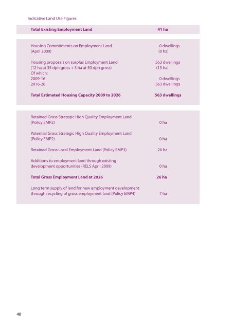
Indicative Land Use FiguresTotal Existing Employment LandHousing Commitments on Employment Land(April 2009)41 ha0 dwellings(0 ha)Housing proposals on surplus Employment Land563 dwellings(12 ha at 35 dph gross + 3 ha at 50 dph gross) (15 ha)Of which:2009-16 0 dwellings2016-26 563 dwellingsTotal Estimated Housing Capacity 2009 to 2026Retained Gross Strategic High Quality Employment Land(Policy EMP2)Potential Gross Strategic High Quality Employment Land(Policy EMP2)563 dwellings0 ha0 haRC3.8Creating Sustainable Communities• New residential development areas fall within the Inner City Core housing market area (asdefined in the Wolverhampton Housing Needs Study 2007), with particular needs identifiedfor market flats and for a large amount of affordable housing of all types and sizes.• Higher density housing concentrated in the northern part of the area closest to the City Centreas part of a mixed office / commercial quarter.• The provision of larger family housing in higher quality environments, building on strongcommunity ties, would help to retain local BME residents, and improve the socio economicmix. The area south of Pountney Street and around Graisley Recreation Ground has theopportunity to meet these needs.• All Saints Renewal Area to the east of the Regeneration Corridor a priority for renewing andsome redevelopment of a low demand under stress housing area with a focus on improvingthe private rented housing sector. Potential for joint private / public sector partnershipworking as part of the redevelopment of the Royal Hospital site within the City Centre area.• The relocated St Luke’s Primary School has met the need for accessible primary school placesin the area.• The area is served by Colton Hills and Parkfield High Secondary Schools. The Building Schoolsfor the Future proposals for the Bilston Academy will replace Parkfields High School. Need toimprove public transport access from the area to this existing and proposed secondary schoolprovision.• There is currently adequate access to GP surgeries in all parts of the corridor with existingor potential housing. The proposed Primary Health Care facility at the Royal Hospital site willfurther enhance existing provision.Retained Gross Local Employment Land (Policy EMP3)Additions to employment land through existingdevelopment opportunities (RELS April 2009)Total Gross Employment Land at 2026Long term supply of land for new employment developmentthrough recycling of gross employment land (Policy EMP4)26 ha0 ha26 ha7 haRC3.9The Economy, Employment & Centres• Managed approach to the redevelopment of employment premises in the northern andcentral parts of the area which recognises the needs of existing businesses including thepotential for their relocation.• It will be essential to retain and promote improvements to the Moorfields Quarter Industrialarea, to ensure that sufficient local jobs are retained to support the local economy as largescale change progresses. This area contains some large manufacturing companies and has thepotential to accommodate new investment through limited redevelopment andrefurbishment of historic buildings.• High density business and commercial development in the northern part of the area close tothe City Centre ring road.• Areas for new housing development have good access to local shopping facilities includingaccess to fresh food (Policy CEN6).• New investment in the <strong>Dudley</strong> Road (Blakenhall) Local Centre consolidated through newshops and open space at the Blakenhall Gardens redevelopment.• Other retail development in the area to be small scale to meet the needs of the residentpopulation as set out in Policy CEN6.RC3.10 Transportation & Accessibility• The Graiseley (northern) area will benefit from remodelling of the internal road network, inparticular better east-west linkages between Penn Road and Birmingham Road.• Improved pedestrian linkages through the area and to the City Centre. In particular the routesbetween new housing and mixed use development in the area across the ring road to the St •• Johns Church quarter of the City Centre and through the Moorfields Quarter.• Potential remodelling of the Birmingham New Road / <strong>Dudley</strong> Road junctions, and the LeaRoad / Penn Road junction.40 41