Lost, A Desert River and its Native Fishes - Sierra Club
Lost, A Desert River and its Native Fishes - Sierra Club
Lost, A Desert River and its Native Fishes - Sierra Club

You also want an ePaper? Increase the reach of your titles
YUMPU automatically turns print PDFs into web optimized ePapers that Google loves.
Fig. 28. Photograph of Boulder Dam, 5119A. Courtesy of<br />
the Bureau of Reclamation, Boulder City, Nevada.<br />
Hoover Dam impounds Lake Mead, which extends<br />
115 miles upstream into the Gr<strong>and</strong> Canyon. It has 550<br />
miles of shoreline <strong>and</strong> is a maximum width of 8 miles. The<br />
reservoir is the largest by volume in North America <strong>and</strong> is<br />
capable of holding nearly 28 maf of water. The lake‘s surface<br />
area is roughly 162,700 acres with a maximum depth<br />
of 550 feet.<br />
Parker Dam<br />
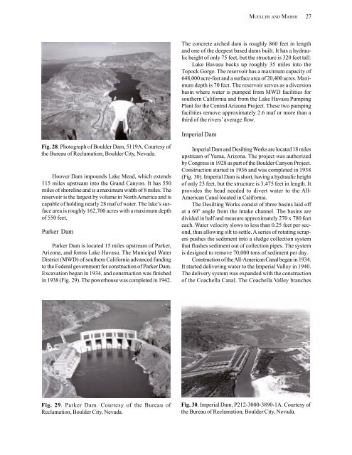
Parker Dam is located 15 miles upstream of Parker,<br />
Arizona, <strong>and</strong> forms Lake Havasu. The Municipal Water<br />
District (MWD) of southern California advanced funding<br />
to the Federal government for construction of Parker Dam.<br />
Excavation began in 1934, <strong>and</strong> construction was finished<br />
in 1938 (Fig. 29). The powerhouse was completed in 1942.<br />
Fig. 29. Parker Dam. Courtesy of the Bureau of<br />
Reclamation, Boulder City, Nevada.<br />
MUELLER AND MARSH 27<br />
The concrete arched dam is roughly 860 feet in length<br />
<strong>and</strong> one of the deepest based dams built. It has a hydraulic<br />
height of only 75 feet, but the structure is 320 feet tall.<br />
Lake Havasu backs up roughly 35 miles into the<br />
Topock Gorge. The reservoir has a maximum capacity of<br />
648,000 acre-feet <strong>and</strong> a surface area of 20,400 acres. Maximum<br />
depth is 70 feet. The reservoir serves as a diversion<br />
basin where water is pumped from MWD facilities for<br />
southern California <strong>and</strong> from the Lake Havasu Pumping<br />
Plant for the Central Arizona Project. These two pumping<br />
facilities remove approximately 2.6 maf or more than a<br />
third of the rivers‘ average flow.<br />
Imperial Dam<br />
Imperial Dam <strong>and</strong> Desilting Works are located 18 miles<br />
upstream of Yuma, Arizona. The project was authorized<br />
by Congress in 1928 as part of the Boulder Canyon Project.<br />
Construction started in 1936 <strong>and</strong> was completed in 1938<br />
(Fig. 30). Imperial Dam is short, having a hydraulic height<br />
of only 23 feet, but the structure is 3,475 feet in length. It<br />
provides the head needed to divert water to the All-<br />
American Canal located in California.<br />
The Desilting Works consist of three basins laid off<br />
at a 60° angle from the intake channel. The basins are<br />
divided in half <strong>and</strong> measure approximately 270 x 780 feet<br />
each. Water velocity slows to less than 0.25 feet per second,<br />
thus allowing silt to settle. A series of rotating scrapers<br />
pushes the sediment into a sludge collection system<br />
that flushes sediment out of collection pipes. The system<br />
is designed to remove 70,000 tons of sediment per day.<br />
Construction of the All-American Canal began in 1934.<br />
It started delivering water to the Imperial Valley in 1940.<br />
The delivery system was exp<strong>and</strong>ed with the construction<br />
of the Coachella Canal. The Coachella Valley branches<br />
Fig. 30. Imperial Dam, P212-3000-3890-1A. Courtesy of<br />
the Bureau of Reclamation, Boulder City, Nevada.