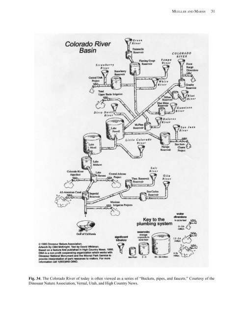
MUELLER AND MARSH 31 Fig. 34. The Colorado <strong>River</strong> of today is often viewed as a series of —Buckets, pipes, <strong>and</strong> faucets.“ Courtesy of the Dinosaur Nature Association, Vernal, Utah, <strong>and</strong> High Country News.
32 INFORMATION AND TECHNOLOGY REPORT--2002-0010 Today, that boat trip would have to begin at Lake Mead, where the river‘s flow is the greatest <strong>and</strong> proceed downstream where water diversions continuously shrink the river to a point where flow completely disappears. Traveling Downstream from the Gr<strong>and</strong> Canyon by Boat Our boat journey would start in the lower end of the Gr<strong>and</strong> Canyon. The Colorado <strong>River</strong> is still an impressive river to anyone privileged to float through the Gr<strong>and</strong> Canyon. Here, evidence of man‘s impact is often lost to the casual observer. The river is only slightly turbid, but occasional summer storms flood side canyons <strong>and</strong> —muddy“ the water. The large amounts of sediment that once flowed through the canyon are now deposited in the headwaters of Lake Powell <strong>and</strong> other upstream dams. In Lake Powell, large amounts of sediment have already filled portions of the reservoir, piling up more than 50 feet deep <strong>and</strong> growing at the inflow areas. The Gr<strong>and</strong> Canyon no longer experiences the cascading roar of unabated spring runoffs or the droughts that come with late summer. Flows are meticulously managed by Reclamation at Glen Canyon Dam to meet operational criteria that consider available flood storage, needs of river runners, a blue ribbon trout fishery, hydroelectric dem<strong>and</strong>s, <strong>and</strong> downstream water rights. Mother nature no longer dictates the seasonal rhythm of the river, man does. At full pool, Lake Mead backs up into the mouth of Gr<strong>and</strong> Canyon, where the river is slowed by the influence of the lake (Fig. 35). The lake extends over 100 km upstream of Hoover Dam where we no longer rely on the current to propel us downstream. <strong>River</strong> waters undergo a dramatic physical <strong>and</strong> chemical change as they journey through Lake Mead. Flow is slowed to mere inches per day, which allows suspended sediments to settle out. Waters become crystal clear <strong>and</strong> by the time they reach the center of Lake Mead, one can easily see 40 feet into the water. Reservoir waters become thermally <strong>and</strong> chemically stratified most of the year. Summer heat warms the lake‘s surface where evaporation can exceed 7 feet of water per year. Evaporation concentrates salts left behind. Cold dense water sinks to the reservoir‘s bottom, which can exceed a depth of 450 feet near the dam while warmer <strong>and</strong> less dense waters remain near the surface. Water temperatures during the summer can range from 90° F on the surface to 48° F near the reservoir‘s bottom. The water temperature <strong>and</strong> density gradient (stratification) that develop results in separate layers of water column that do not mix. LaBounty <strong>and</strong> Horn (1997) report that on rare occasions, the river can actually flow between these stratified layers to Hoover Dam. Likewise, it is possible for pollutants <strong>and</strong> treated sewage effluent to concentrate at various depths <strong>and</strong> pose potential problems for municipal water uses. If water temperature cools enough <strong>and</strong> equalizes during the winter, the entire water column can freely mix in a process called —reservoir turn over.“ This occurs once every few years <strong>and</strong> reduces pollution by simple dilution. Unfortunately this does not occur every year. Reservoirs are typically more productive than rivers. Nutrients brought in by the river or sewage treatment plants mix with surface waters where the sun‘s warmth stimulates algal growth. Surface waters become rich with phyto- <strong>and</strong> zooplankton, which thrive in calm, warm water. Plankton in turn provide the basic food used by young fish but it can also cause water quality problems. Both the Virgin <strong>River</strong> <strong>and</strong> Las Vegas Wash now produce more flow during the summer due to wastewater discharges. The lower Virgin <strong>River</strong> historically dried up during the summer. Today, water treatment in the Saint George, Utah, <strong>and</strong> Mesquite, Nevada areas augments summer flow.A similar condition exists in Las Vegas Wash where Las Vegas treated effluent pours into Lake Mead at a rate of more than 1,500 gallons per second. Today, Las Vegas Wash is the largest (sustained flow) tributary downstream of the Gr<strong>and</strong> Canyon. At the south end of Boulder Basin, we finally reach Hoover Dam, our first navigational barrier. Here, we have to portage around the dam. Continuing Downstream of Hoover Dam Water released at Hoover Dam has been totally transformed. The once turbid, high desert river now resembles a clear, cold, <strong>and</strong> slightly more saline mountain stream. Waters leaving Lake Mead discharge into Lake Mohave, which backs up to the base of Hoover Dam. The silt, mud, <strong>and</strong> s<strong>and</strong> that historically flowed through Black Canyon are now trapped in Lake Mead <strong>and</strong> Lake Powell. Fine materials were washed downstream a long time ago, causing a process known as armoring. Water releases from the dams have cut a deep channel lined with large rock. Lieutenant Ives would have marveled at the water‘s clarity <strong>and</strong> the ease in which we now navigate down Black Canyon. The loss of scouring s<strong>and</strong>, crystal clear water, <strong>and</strong> rock substrate provides ideal conditions for the growth of Cladophora. This filamentous green algae forms dense mats of underwater vegetation that cover sections of the river‘s bottom. Aquatic vegetation is rich with amphipods, aquatic insects, <strong>and</strong> other fish foods. Today, the river supports a nonnative trout fishery that a century ago could have only been found high in the mountains. <strong>River</strong> current can be detected on the surface 12 to 20 miles downstream, depending on the rate of discharge