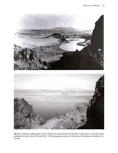
MUELLER AND MARSH 33 Fig. 35. Comparative photographs of the Colorado <strong>River</strong> just upstream of Boulder Canyon prior to, <strong>and</strong> after being inundated by Lake Mead (1926 <strong>and</strong> 2001). 1926 photograph courtesy of the Bureau of Reclamation, Boulder City, Nevada.
34 INFORMATION AND TECHNOLOGY REPORT--2002-0010 <strong>and</strong> lake elevation. Cold releases are typically denser than reservoir surface waters which cause the river to dive, or flow along the bottom of the reservoir near Eldorado Canyon. This canyon was the site of a popular gold mine <strong>and</strong> steamboat l<strong>and</strong>ing called Nelson‘s L<strong>and</strong>ing. Before the turn of the twentieth century, Eldorado represented the largest population center in southern Nevada. The river continues <strong>its</strong> journey through Lake Mohave toward Davis Dam. Forty-two miles downstream from Hoover Dam, it passes Cottonwood Marina, named for the large cottonwood galleries that once bordered the river. Approximately 10 miles further, it flows over Pyramid Canyon which historically contained a series of large river rapids which seriously challenged upstream navigation. The natural roar of the river has been replaced by the hum of generators at Davis Dam. Water exiting the turbines at Davis Dam once again flows unobstructed past the glimmering casino lights <strong>and</strong> slot machines of Laughlin, Nevada, <strong>and</strong> Bullhead City, Arizona. The old riverboat l<strong>and</strong>ing <strong>and</strong> river crossing of Hardyville are long forgotten except at the Mohave County Museum. Today, tourists drive down Highway 68 which follows the old Beal Trail <strong>and</strong> cross the river by bridge or by one of the many casino tour boats. As we float past Bullhead City, Arizona, the levee becomes crowded with expensive vacation homes that form a maze of concrete walls, piling, supporting steel, porches, <strong>and</strong> docks. Past town, we reach the Mojave Tribes l<strong>and</strong> where Fort Mohave once proudly stood overlooking the river. Today, only the concrete foundation remains. Here the river channel has degraded 8 to 10 feet. Our exit from Nevada <strong>and</strong> entry into California is marked by two l<strong>and</strong>marks: one historic, the other new. Boundary Cone is a prominent column of rock set against the Black Mountains in Arizona. The l<strong>and</strong>scape has not changed much since Möllhausen painted it 144 years ago. More obvious is the Avi Casino, a Fort Mojave Indian business which s<strong>its</strong> on the river bank near the Nevada <strong>and</strong> California border. L<strong>and</strong> along the river is relatively undeveloped where it flows through the reservation except for the California bank which has a high armored levee. The cottonwoods <strong>and</strong> willows have been replaced by rip-rap (rock) <strong>and</strong> brushy salt cedar. Historically, the active river channel was nearly 2 miles wide but today the river seldom exceeds 150 yards. At quarter-mile intervals, irrigation pumps sit on high platforms along the shore. During spring <strong>and</strong> summer these pumps suck water from the river to irrigate thous<strong>and</strong>s of acres of farml<strong>and</strong>. Recreational homes <strong>and</strong> levees border both banks of the river as we pass the Reservation <strong>and</strong> approach Needles, California. Several new river homes are under construction <strong>and</strong> —For Sale“ signs can be seen in front of the lots. Within a couple of miles we are again surrounded by farml<strong>and</strong>. Along the eastern shore we enter the Havasu National Wildlife Refuge. This is the huge Topock Swamp complex. Today the Fish <strong>and</strong> Wildlife Service (FWS) manages a large wetl<strong>and</strong> complex that is artificially maintained through a system of levees <strong>and</strong> water control structures. The active river channel once was nearly 2 miles wide, me<strong>and</strong>ering across the broad floodplain covered by side channels, sloughs, <strong>and</strong> old oxbows. Dredging during the 1950‘s <strong>and</strong> 1960‘s lowered the water table <strong>and</strong> drained much of the marsh <strong>and</strong> old oxbow lakes. Looking at the river today, it is difficult to imagine the Colorado <strong>River</strong> being nearly 2 miles wide (Fig. 36). The wide expanses of flat, dry floodplain <strong>and</strong> irrigated farml<strong>and</strong> is a testament to the effects of human intervention. At one time steamboats ran along the Arizona shoreline to deliver freight to the mining camps around Oatman, Arizona. The old riverboat l<strong>and</strong>ing was nearly 4 miles east of the current river channel where 150foot steamboats delivered thous<strong>and</strong>s of tons of freight <strong>and</strong> transported ore to stamp mills. The last remnants of the wooden l<strong>and</strong>ing were destroyed a few years ago by a brush fire. Once again the valley narrows, being confined by the Whale <strong>and</strong> Needle Mountains. The settlement of Fig. 36. Comparative photographs (1908 <strong>and</strong> 2001) taken of the Colorado <strong>River</strong> at Needles, California. 1908 photograph courtesy of the Mohave County Historical Society.