An Update on the Disappearing Salt Marshes of Jamaica Bay, New ...
An Update on the Disappearing Salt Marshes of Jamaica Bay, New ...
An Update on the Disappearing Salt Marshes of Jamaica Bay, New ...

You also want an ePaper? Increase the reach of your titles
YUMPU automatically turns print PDFs into web optimized ePapers that Google loves.
<str<strong>on</strong>g>An</str<strong>on</strong>g> <str<strong>on</strong>g>Update</str<strong>on</strong>g> <strong>on</strong> <strong>the</strong> <strong>Disappearing</strong> <strong>Salt</strong> <strong>Marshes</strong><br />
Prepared by:<br />
<strong>of</strong> <strong>Jamaica</strong> <strong>Bay</strong>, <strong>New</strong> York<br />
Gateway Nati<strong>on</strong>al Recreati<strong>on</strong> Area,<br />
Nati<strong>on</strong>al Park Service, U.S. Department <strong>of</strong> <strong>the</strong> Interior<br />
<strong>Jamaica</strong> <strong>Bay</strong> Watershed Protecti<strong>on</strong> Plan Advisory Committee<br />
August 2, 2007
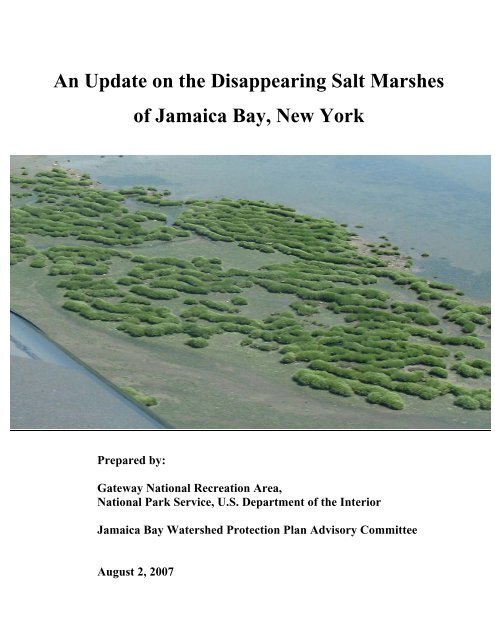
Photo Credit:<br />
M. Kathryn Mellander. 2002, July. Nati<strong>on</strong>al Park Service, Gateway Nati<strong>on</strong>al Recreati<strong>on</strong> Area.<br />
Secti<strong>on</strong> <strong>of</strong> Black Wall Marsh.
AN UPDATE ON THE DISAPPEARING SALT MARSHES OF JAMAICA BAY, NEW YORK<br />
Prepared by Gateway Nati<strong>on</strong>al Recreati<strong>on</strong> Area, Nati<strong>on</strong>al Park Service, U.S. Department <strong>of</strong> <strong>the</strong> Interior<br />
and <strong>the</strong> <strong>Jamaica</strong> <strong>Bay</strong> Watershed Protecti<strong>on</strong> Plan Advisory Committee<br />
August 2, 2007<br />
Table <strong>of</strong> C<strong>on</strong>tents<br />
Executive Summary ............................................................................................................................................. 1<br />
Background........................................................................................................................................................... 2<br />
Sidebar: The Value <strong>of</strong> <strong>Jamaica</strong> <strong>Bay</strong>’s Wetlands .................................................................................... 3<br />
Methodology......................................................................................................................................................... 4<br />
Sidebar: Why Are <strong>the</strong> <strong>Jamaica</strong> <strong>Bay</strong>’s Wetlands <strong>Disappearing</strong>?.............................................................. 6<br />
Results and Discussi<strong>on</strong> ......................................................................................................................................... 8<br />
C<strong>on</strong>clusi<strong>on</strong> .......................................................................................................................................................... 16<br />
Appendix A: Local Law 71<br />
Appendix B: List <strong>of</strong> Committee Members Including Affiliati<strong>on</strong>s and Biographies<br />
Appendix C: Int. No. 376<br />
Appendix D: Mapping Reference Panel<br />
Appendix E: Mapping Classificati<strong>on</strong> Descripti<strong>on</strong>s<br />
Appendix F: Vegetated Marsh Maps for East High, Yellow Bar, Black Wall, Elders Point, and Pumpkin Patch<br />
<strong>Marshes</strong>
Executive Summary<br />
For at least a decade, it has been recognized that <strong>Jamaica</strong> <strong>Bay</strong>’s tidal wetlands are rapidly disappearing. In 2001,<br />
mapping analysis c<strong>on</strong>ducted by <strong>the</strong> <strong>New</strong> York State Department <strong>of</strong> Envir<strong>on</strong>mental C<strong>on</strong>servati<strong>on</strong> (DEC) showed<br />
that between 1924 and 1999, half <strong>of</strong> <strong>the</strong> bay’s vegetated marsh islands disappeared. 1 Even more alarmingly, DEC<br />
determined that <strong>the</strong> rate <strong>of</strong> loss had been increasing over time. 2 Between 1994 and 1999, for example, <strong>the</strong> rate <strong>of</strong><br />
loss had nearly doubled from that <strong>of</strong> 1974-1994; assuming that rate <strong>of</strong> loss c<strong>on</strong>tinued baywide into <strong>the</strong> future, it<br />
was calculated that <strong>the</strong> marsh islands would completely vanish by 2024. 3<br />
The <strong>Jamaica</strong> <strong>Bay</strong> Watershed Protecti<strong>on</strong> Plan Advisory Committee (Advisory Committee or Committee), created<br />
by <strong>New</strong> York City municipal law in 2005, and <strong>the</strong> Gateway Nati<strong>on</strong>al Recreati<strong>on</strong> Area (GNRA), which<br />
encompasses more than half <strong>of</strong> <strong>the</strong> bay within its <strong>Jamaica</strong> <strong>Bay</strong> Unit, c<strong>on</strong>ducted this study to obtain a current<br />
understanding <strong>of</strong> <strong>the</strong> marsh loss problem, and specifically to determine whe<strong>the</strong>r <strong>the</strong> rate <strong>of</strong> loss had c<strong>on</strong>tinued to<br />
accelerate since DEC released its 1999 results. For this report, <strong>the</strong> Committee and GNRA relied up<strong>on</strong><br />
comprehensive (baywide) analysis <strong>of</strong> 2003 satellite imagery and aerial photography previously c<strong>on</strong>ducted by<br />
GNRA. The Committee and GNRA also obtained 2005 aerial photography <strong>of</strong> representative marshes from DEC,<br />
which was <strong>the</strong>n analyzed and extrapolated to <strong>the</strong> bay as a whole, for <strong>the</strong> purpose <strong>of</strong> updating <strong>the</strong> 2003 analysis.<br />
Like <strong>the</strong> DEC analysis, this analysis focused <strong>on</strong>ly <strong>on</strong> <strong>the</strong> salt marsh islands where loss is known to be <strong>the</strong> most<br />
severe, and did not encompass fringe marshes or <strong>the</strong> upper reaches <strong>of</strong> <strong>the</strong> bay bey<strong>on</strong>d John F. Kennedy<br />
Internati<strong>on</strong>al Airport. It is assumed that <strong>the</strong> bay’s fringe marshes, <strong>the</strong> bay’s upper salt marsh, and <strong>the</strong> margins <strong>of</strong><br />
<strong>the</strong> dredge-spoil islands will degrade at a slower pace.<br />
The analysis <strong>of</strong> <strong>the</strong> 2003 satellite imagery and aerial photography and 2005 aerial photography, and comparis<strong>on</strong>s<br />
to earlier aerial photography using <strong>the</strong> protocols described infra, indicate that <strong>the</strong> rate <strong>of</strong> tidal wetlands loss in<br />
<strong>Jamaica</strong> <strong>Bay</strong> c<strong>on</strong>tinues to accelerate. Field observati<strong>on</strong>s support this c<strong>on</strong>clusi<strong>on</strong>. From 1989-2003, <strong>the</strong> calculated<br />
average rate <strong>of</strong> loss was 33 acres per year, compared to a fairly c<strong>on</strong>sistent rate <strong>of</strong> approximately 18 acres per year<br />
from 1951-1989. This supports DEC’s earlier c<strong>on</strong>clusi<strong>on</strong> that <strong>the</strong> marsh loss rate started to rapidly accelerate in<br />
<strong>the</strong> 1990s. By 2003, just 37 percent <strong>of</strong> <strong>the</strong> salt marsh islands that had been present in <strong>Jamaica</strong> <strong>Bay</strong> in 1951 were<br />
calculated to be left. <str<strong>on</strong>g>An</str<strong>on</strong>g>alysis <strong>of</strong> <strong>the</strong> 2005 aerial photography for five selected marshes representing different<br />
areas in <strong>the</strong> bay, and comparis<strong>on</strong>s to <strong>the</strong> 2003 baywide map, yielded startling results. From 2003-2005, just a twoyear<br />
period, it was calculated that four <strong>of</strong> <strong>the</strong> five marshes lost 54 acres, or almost 30 percent <strong>of</strong> <strong>the</strong> extent in 2003<br />
(187 acres) (<strong>the</strong> fifth marsh, Elders Point, which had already lost more than 90 percent <strong>of</strong> its wetlands, remained<br />
approximately <strong>the</strong> same). The analysis indicated that a marsh in <strong>the</strong> south <strong>of</strong> <strong>the</strong> bay, Black Wall, which had been<br />
relatively stable, lost more than half <strong>of</strong> its remaining tidal wetlands over <strong>the</strong> two-year period. At a landscape<br />
scale, what is generally happening <strong>on</strong> <strong>the</strong> marsh islands is that tidal creeks are expanding and vegetated areas are<br />
transforming into mud flats, <strong>the</strong>n to sand flats as <strong>the</strong>y disappear.<br />
Because <strong>the</strong> rate <strong>of</strong> marsh island loss appears to have c<strong>on</strong>tinued to increase, prior projecti<strong>on</strong>s that <strong>the</strong> marsh<br />
islands will disappear by 2024 are also likely too optimistic, probably by a significant margin. In a manner similar<br />
to prior projecti<strong>on</strong>s, if <strong>the</strong> 2003-2005 observed loss for <strong>the</strong> five representative marshes is extrapolated to <strong>the</strong> entire<br />
bay, <strong>the</strong> bay’s marsh islands would be projected to all disappear by 2012, just five years from now. Because this<br />
projecti<strong>on</strong> is based <strong>on</strong> a short time period and marsh loss rates vary between individual marsh islands, some<br />
islands may persist for l<strong>on</strong>ger and some for shorter. It should also be noted that <strong>on</strong>ly two years <strong>of</strong> data to<br />
represent current trends, as well as adequate aerial photography for <strong>on</strong>ly five marshes, was available. It will be<br />
important to collect and analyze additi<strong>on</strong>al years <strong>of</strong> data, including for additi<strong>on</strong>al marshes, to check for possible<br />
bias in this dataset. Also, if loss rates slow when <strong>on</strong>ly elevated vestiges <strong>of</strong> marsh island remain, <strong>the</strong>n <strong>the</strong>se<br />
projecti<strong>on</strong>s will be overly pessimistic, while a c<strong>on</strong>tinued trend towards accelerating loss rates would have <strong>the</strong><br />
opposite effect. Finally, interventi<strong>on</strong> to successfully reverse <strong>the</strong>se trends will obviously affect <strong>the</strong> future scenario.<br />
<strong>Jamaica</strong> <strong>Bay</strong> remains <strong>on</strong>e <strong>of</strong> <strong>the</strong> largest and most productive coastal ecosystems in <strong>the</strong> nor<strong>the</strong>astern United States,<br />
and includes <strong>the</strong> largest tidal wetland complex in <strong>the</strong> <strong>New</strong> York metropolitan area. 4 The bay’s waters and marshes<br />
are c<strong>on</strong>sidered a critical stopover point for migrating birds – estimated to be visited annually by nearly twenty<br />
percent <strong>of</strong> <strong>the</strong> c<strong>on</strong>tinent’s different bird species – and home for more than eighty fish species, as well as many<br />
threatened and endangered species. 5 <strong>Jamaica</strong> <strong>Bay</strong>’s tidal marshes also provide flood protecti<strong>on</strong> for nearby<br />
businesses and residences, and serve as, toge<strong>the</strong>r with <strong>the</strong> wildlife that depend <strong>on</strong> <strong>the</strong>m, a unique recreati<strong>on</strong>al,<br />
aes<strong>the</strong>tic, and cultural resource for <strong>New</strong> York City.<br />
1
Although <strong>the</strong> exact causes <strong>of</strong> <strong>the</strong> accelerating marsh loss remain unknown, <strong>the</strong> gravity <strong>of</strong> <strong>the</strong> problem warrants<br />
immediate acti<strong>on</strong>. Where possible c<strong>on</strong>tributing causes and how to address <strong>the</strong>m have been identified, acti<strong>on</strong><br />
should taken immediately. Poor water quality in <strong>the</strong> bay, and specifically significant nitrogen polluti<strong>on</strong> from <strong>the</strong><br />
city’s wastewater treatment plants, falls into this category. In o<strong>the</strong>r words, as <strong>the</strong> Advisory Committee has<br />
previously recommended, steps to dramatically reduce nitrogen discharges into <strong>the</strong> bay should be undertaken<br />
immediately. In additi<strong>on</strong>, marsh island restorati<strong>on</strong> should be c<strong>on</strong>tinued and expanded in order to help balance out<br />
marsh island loss until its underlying causes are addressed. Finally, <strong>the</strong> scientific and engineering effort to<br />
pinpoint <strong>the</strong> causes <strong>of</strong> <strong>the</strong> marsh loss and how to effectively address <strong>the</strong>m (e.g., determine how to address possible<br />
causes o<strong>the</strong>r than excess nitrogen) should be immediately and significantly scaled up.<br />
Background<br />
In <strong>the</strong> late 1990s, DEC began analyzing aerial photography <strong>of</strong> <strong>Jamaica</strong> <strong>Bay</strong> dating back to 1924 in collaborati<strong>on</strong><br />
with c<strong>on</strong>cerned local groups, such as <strong>the</strong> <strong>Jamaica</strong> <strong>Bay</strong> Eco Watchers. In 2001, <strong>the</strong> agency produced <strong>the</strong> first<br />
<strong>of</strong>ficial report <strong>on</strong> <strong>the</strong> extent <strong>of</strong> <strong>the</strong> bay’s tidal wetlands loss. It would be an underestimate to say that this report<br />
c<strong>on</strong>firmed c<strong>on</strong>cerns that <strong>the</strong> bay’s wetlands had been disappearing – indeed, DEC calculati<strong>on</strong>s show that between<br />
1924 and 1999 <strong>the</strong> bay had lost fully half <strong>of</strong> its tidal wetlands. 6 Even more alarming, <strong>the</strong> analysis showed that <strong>the</strong><br />
rate <strong>of</strong> loss had been accelerating over time. From 1924 to 1974, DEC calculated that 780 acres <strong>of</strong> marsh islands<br />
were lost because <strong>of</strong> direct dredge and fill activities (which were more strictly regulated after <strong>the</strong> 1970s) and 510<br />
acres were lost due to o<strong>the</strong>r reas<strong>on</strong>s at roughly 10 acres a year. 7 More than 500 acres were again lost between<br />
1974 and 1994 – approximately <strong>the</strong> same loss <strong>of</strong> land in half <strong>the</strong> time. <str<strong>on</strong>g>An</str<strong>on</strong>g>d between 1994 and 1999, <strong>the</strong> rate<br />
increased again, with DEC calculating an additi<strong>on</strong>al 220 acres <strong>of</strong> loss. 8 DEC roughly estimated that if <strong>the</strong> loss<br />
were to c<strong>on</strong>tinue at <strong>the</strong> rate <strong>of</strong> 44 acres per year, it was predicted that – 100 years after <strong>the</strong> first aerial mapping <strong>of</strong><br />
<strong>the</strong> bay in 1924 – all <strong>of</strong> <strong>the</strong> marsh islands in <strong>Jamaica</strong> <strong>Bay</strong> could be g<strong>on</strong>e. 9<br />
While restorati<strong>on</strong> efforts in <strong>the</strong> bay had been <strong>on</strong>going for a number <strong>of</strong> years, DEC’s report triggered an intensified<br />
effort to protect and restore salt marsh and to determine <strong>the</strong> cause <strong>of</strong> <strong>the</strong> wetlands loss and possible soluti<strong>on</strong>s. In<br />
1999, <strong>the</strong> <strong>Jamaica</strong> <strong>Bay</strong> Ecosystem Research and Restorati<strong>on</strong> Team (JABERRT) investigated twelve potential salt<br />
marsh restorati<strong>on</strong> sites within <strong>Jamaica</strong> <strong>Bay</strong>, and several <strong>of</strong> <strong>the</strong>se sites (e.g., Gerritsen <strong>Bay</strong> and Spring Creek) have<br />
been partially restored. 10 In 2001, GNRA c<strong>on</strong>vened a “blue ribb<strong>on</strong>” panel <strong>of</strong> nati<strong>on</strong>al experts to examine <strong>the</strong><br />
possible causes <strong>of</strong> <strong>the</strong> bay’s marsh loss, focusing mainly <strong>on</strong> reduced sediment supply and suspensi<strong>on</strong> problems.<br />
The panel recommended a number <strong>of</strong> additi<strong>on</strong>al studies and restorati<strong>on</strong> projects, such as <strong>the</strong> Big Egg Marsh thin<br />
layer sediment spraying, to add sediment to areas, which are <strong>the</strong>n planted to help restore healthy marsh<br />
elevati<strong>on</strong>s. 11<br />
In 2005, <strong>New</strong> York City resp<strong>on</strong>ded to <strong>the</strong> marsh loss crisis, as well as o<strong>the</strong>r problems besetting <strong>Jamaica</strong> <strong>Bay</strong>, by<br />
enacting Local Law 71. The law required <strong>the</strong> <strong>New</strong> York City Department <strong>of</strong> Envir<strong>on</strong>mental Protecti<strong>on</strong> (DEP) to<br />
develop a comprehensive <strong>Jamaica</strong> <strong>Bay</strong> Watershed Protecti<strong>on</strong> Plan (Plan) to “restore and maintain <strong>the</strong> water<br />
quality and ecological integrity <strong>of</strong> <strong>Jamaica</strong> bay.” 12 (See Appendix A.) The new law also established <strong>the</strong> Advisory<br />
Committee; its seven members are charged with assisting DEP in Plan development. (See Appendix B.) ♦<br />
Not surprisingly, <strong>Jamaica</strong> <strong>Bay</strong>’s marsh loss became <strong>on</strong>e <strong>of</strong> <strong>the</strong> Advisory Committee’s priority c<strong>on</strong>cerns. The<br />
Committee was surprised to find, despite <strong>the</strong> recognized gravity <strong>of</strong> <strong>the</strong> problem and <strong>the</strong> attenti<strong>on</strong> it has received,<br />
<strong>the</strong> current extent <strong>of</strong> <strong>the</strong> marsh loss was unknown, and specifically that it was unknown whe<strong>the</strong>r <strong>the</strong> rate <strong>of</strong> loss<br />
was c<strong>on</strong>tinuing to increase. DEC has not updated its analysis with post-1999 data. Although GNRA staff had<br />
♦ The original timeline in <strong>the</strong> law called for submissi<strong>on</strong> <strong>of</strong> <strong>the</strong> final Plan by September 1, 2006; this timeline was extended to<br />
October 1, 2007 by Introducti<strong>on</strong> 376 (See Appendix C). Local Law 71, as amended, provided an iterative process for <strong>the</strong><br />
Plan’s development, with several opportunities for <strong>the</strong> Advisory Committee to provide formal input to DEP. Pursuant to this<br />
process, <strong>on</strong> June 29, 2006, <strong>the</strong> Advisory Committee provided Planning for <strong>Jamaica</strong> <strong>Bay</strong>’s Future: Preliminary<br />
Recommendati<strong>on</strong>s <strong>on</strong> <strong>the</strong> <strong>Jamaica</strong> <strong>Bay</strong> Watershed Protecti<strong>on</strong> Plan, <strong>on</strong> September 1, 2006, DEP submitted an Interim Report<br />
<strong>on</strong> <strong>the</strong> <strong>Jamaica</strong> <strong>Bay</strong> Watershed Protecti<strong>on</strong> Plan, and <strong>on</strong> March 1, 2007 DEP submitted its Draft <strong>Jamaica</strong> <strong>Bay</strong> Watershed<br />
Protecti<strong>on</strong> Plan (Draft Plan). On June 1, 2007, <strong>the</strong> Advisory Committee provided its Final Recommendati<strong>on</strong>s <strong>on</strong> <strong>the</strong> <strong>Jamaica</strong><br />
<strong>Bay</strong> Watershed Protecti<strong>on</strong> Plan; however, because <strong>the</strong> Committee believes that <strong>the</strong> DEP’s Draft Plan did not c<strong>on</strong>tain <strong>the</strong> level<br />
<strong>of</strong> detail called for by <strong>the</strong> legislati<strong>on</strong>, <strong>the</strong> Committee intends to supplement <strong>the</strong>ir recommendati<strong>on</strong>s following <strong>the</strong> submissi<strong>on</strong><br />
<strong>of</strong> DEP’s final Plan <strong>on</strong> October 1, 2007.<br />
2
The Value <strong>of</strong> <strong>Jamaica</strong> <strong>Bay</strong>’s Wetlands<br />
Made <strong>of</strong> glacial till left behind during <strong>the</strong> last ice age and shaped by erosi<strong>on</strong> and wave acti<strong>on</strong>, <strong>the</strong> open water and<br />
wetlands porti<strong>on</strong> <strong>of</strong> <strong>Jamaica</strong> <strong>Bay</strong> is approximately eight miles l<strong>on</strong>g, four miles wide and covers 26,645 acres, more<br />
than half <strong>of</strong> which is part <strong>of</strong> Gateway Nati<strong>on</strong>al Recreati<strong>on</strong> Area’s <strong>Jamaica</strong> <strong>Bay</strong> Unit. 13 Wetlands, also known as<br />
marshes, are land areas intermittently covered with shallow water or have soil saturated with moisture. 14<br />
<strong>Salt</strong>water marshes, such as those found in <strong>Jamaica</strong> <strong>Bay</strong>, are a type <strong>of</strong> tidal wetland, which become flooded<br />
periodically by tidal acti<strong>on</strong>. 15<br />
<strong>Jamaica</strong> <strong>Bay</strong> comprises <strong>on</strong>e <strong>of</strong> <strong>the</strong> largest and most productive coastal ecosystems in <strong>the</strong> nor<strong>the</strong>astern United<br />
States, and includes <strong>the</strong> largest tidal wetland complex in <strong>the</strong> <strong>New</strong> York metropolitan area. 16 These wetlands play a<br />
vital role in <strong>the</strong> city’s ecological and ec<strong>on</strong>omic health:<br />
� <strong>Jamaica</strong> <strong>Bay</strong>’s marshes provide critical wildlife habitat for more than eighty fish species and for nearly twenty<br />
percent <strong>of</strong> <strong>the</strong> c<strong>on</strong>tinent’s species <strong>of</strong> birds that visit <strong>the</strong> bay every year as <strong>the</strong>y traverse <strong>the</strong> Eastern Flyway<br />
migrati<strong>on</strong> route to <strong>the</strong>ir breeding grounds fur<strong>the</strong>r north. <strong>Salt</strong>water marshes not <strong>on</strong>ly serve as nursery sites for<br />
finfish and shellfish, but also for feeding, spawning, and refuge from predators; 17 edge marshes are used by<br />
transient and resident fish and crustacean species, while interior marshes provide an important food sources<br />
for adult transient fishes. 18 Endangered and threatened species like peregrine falc<strong>on</strong>s, piping plovers, and <strong>the</strong><br />
Atlantic Ridley sea turtle reside in or visit <strong>the</strong> bay, al<strong>on</strong>g with more than 325 kinds <strong>of</strong> waterfowl and<br />
shorebirds (sixty-two <strong>of</strong> which are c<strong>on</strong>firmed to breed in <strong>the</strong> bay). 19 The bay’s wildlife depends <strong>on</strong> <strong>the</strong><br />
wetlands for survival.<br />
� <strong>Jamaica</strong> <strong>Bay</strong>’s wetlands mitigate flooding and provide shoreline erosi<strong>on</strong> c<strong>on</strong>trol for homes and businesses in<br />
Brooklyn and Queens. The neighborhoods surrounding <strong>Jamaica</strong> <strong>Bay</strong> are home to more than five hundred<br />
thousand <strong>New</strong> Yorkers and <strong>the</strong> marshes serve as coastline buffers from waves, tides, winds, and floods, and<br />
can help reduce coastline erosi<strong>on</strong> and property damage during storm events. 20 Marsh grass can decrease wave<br />
energy 10-fold and, due to its unique properties, even trap sediment instead <strong>of</strong> eroding during storm events. 21<br />
With intense “hundred-year flood” storms predicted to become twice or even four times more frequent from<br />
global warming, natural barriers like wetlands are more important than ever. 22<br />
� The bay’s wetlands act as <strong>the</strong> ecosystem’s kidneys to filter out pollutants in <strong>the</strong> water. Wetlands act as<br />
nutrient buffers for coastal waters, capable <strong>of</strong> transforming large quantities <strong>of</strong> organic pollutants, suspended<br />
solids, and metals from run<strong>of</strong>f and wastewater effluent into organic matter, and thus act as sinks as organic<br />
matter is buried through marsh accreti<strong>on</strong> and as bacterial denitrificati<strong>on</strong> releases nitrogen gas into <strong>the</strong> air. 23<br />
This cycling is important because overabundance <strong>of</strong> nitrogen and organic matter spurs <strong>the</strong> growth <strong>of</strong> algae<br />
blooms that turn <strong>the</strong> bay’s waters murky. As <strong>the</strong> algae die, sink to <strong>the</strong> bottom, and decompose, <strong>the</strong> water’s<br />
oxygen levels drop, killing any aquatic life unable to swim away. 24 <strong>Salt</strong> marshes’ roles as nutrient buffers are<br />
amplified in cases where <strong>the</strong>re is anthropogenic nutrient enrichment in coastal waters (e.g., sewage effluent<br />
and agriculture), but <strong>the</strong> efficiency by which <strong>the</strong>y do so is hampered by excessive nutrient loadings. 25 It<br />
should be noted that, in <strong>the</strong> case <strong>of</strong> <strong>Jamaica</strong> <strong>Bay</strong>, <strong>the</strong> four city sewage treatment plants that surround <strong>the</strong> bay<br />
discharge more than 250 milli<strong>on</strong> gall<strong>on</strong>s <strong>of</strong> treated wastewater c<strong>on</strong>taining thirty to forty thousand pounds <strong>of</strong><br />
nitrogen into <strong>the</strong> bay every day. 26 This is far too much nitrogen for <strong>the</strong> bay’s current wetlands to assimilate –<br />
<strong>on</strong>e estimate puts <strong>the</strong> removal capacity <strong>of</strong> existing marshes somewhere between a tenth and a fifth <strong>of</strong> <strong>the</strong> total<br />
nitrogen inputs. 27<br />
� <strong>Salt</strong> marshes have <strong>the</strong> highest primary productivity <strong>of</strong> any floral community; moreover, <strong>the</strong> algal and<br />
phytoplankt<strong>on</strong> communities <strong>the</strong>y support significantly c<strong>on</strong>tribute to overall rates <strong>of</strong> carb<strong>on</strong> fixati<strong>on</strong>, which<br />
helps reduce carb<strong>on</strong> dioxide in <strong>the</strong> atmosphere. 28 Each acre <strong>of</strong> Spartina grass produces ten t<strong>on</strong>s <strong>of</strong> organic<br />
matter annually, which <strong>the</strong>n enters <strong>the</strong> food chain to provide fuel for higher orders <strong>of</strong> organisms. 29 In order to<br />
reach Mayor Bloomberg’s PlaNYC goal <strong>of</strong> reducing <strong>the</strong> city’s greenhouse gas emissi<strong>on</strong>s 30 percent by 2030,<br />
we will need to protect all <strong>of</strong> <strong>the</strong> city’s green space – especially <strong>the</strong> bay’s wetlands. 30<br />
� The marshes serve as a recreati<strong>on</strong>al haven and living laboratory with educati<strong>on</strong>, research, and recreati<strong>on</strong>al<br />
opportunities. Groups like <strong>the</strong> American Littoral Society provide educati<strong>on</strong>al programs about <strong>the</strong> bay’s<br />
resources to schools and civic groups, and <strong>the</strong> <strong>New</strong> York/<strong>New</strong> Jersey Harbor Estuary Program has broadcast<br />
educati<strong>on</strong> programs for high school students live from <strong>the</strong> bay. 31 Accessible to America’s most populated city<br />
by subway and bus, milli<strong>on</strong>s <strong>of</strong> people who visit <strong>the</strong> area each year c<strong>on</strong>sider <strong>the</strong> waters, parks, and open space<br />
surrounding <strong>the</strong> bay “a sanctuary or haven from <strong>the</strong> stress <strong>of</strong> <strong>the</strong> city.” 32<br />
3
c<strong>on</strong>ducted some additi<strong>on</strong>al and, in certain respects, enhanced, mapping <strong>of</strong> <strong>the</strong> bay, including using 2003 aerial<br />
photography, this informati<strong>on</strong> required fur<strong>the</strong>r updating and analysis.<br />
The Advisory Committee and GNRA decided that <strong>the</strong>y would attempt to update <strong>the</strong> picture <strong>of</strong> <strong>the</strong> bay’s wetlands<br />
loss problems, as such updated informati<strong>on</strong> was almost certain to be relevant to <strong>the</strong> significant decisi<strong>on</strong>s that need<br />
to be made with respect to <strong>the</strong> bay, including as part <strong>of</strong> <strong>the</strong> development and implementati<strong>on</strong> <strong>of</strong> <strong>the</strong> Plan. As<br />
explained in greater detail infra (Methodology), working with mapping analysts at GNRA, <strong>the</strong> Committee has<br />
updated <strong>the</strong> 1999 report findings with a comprehensive look at <strong>the</strong> bay in 2003 obtained from satellite imagery<br />
and aerial photography and, for select marshes, from 2005 aerial photography.<br />
As detailed infra (Results and Discussi<strong>on</strong>), <strong>the</strong> dramatic increase in <strong>the</strong> rate <strong>of</strong> marsh loss we found is shocking.<br />
The Advisory Committee and GNRA present this updated look at <strong>Jamaica</strong> <strong>Bay</strong>’s marsh island loss in <strong>the</strong> hopes<br />
that this analysis will fur<strong>the</strong>r underscore <strong>the</strong> emergency in what is, figuratively, <strong>the</strong> backyard <strong>of</strong> milli<strong>on</strong>s <strong>of</strong> <strong>New</strong><br />
Yorkers, a unit <strong>of</strong> <strong>the</strong> Nati<strong>on</strong>al Park system, and a resource <strong>of</strong> enormous ecological value, and – most importantly<br />
– in order to galvanize us to <strong>the</strong> necessary acti<strong>on</strong>. Given <strong>the</strong> short time that appears to be remaining for <strong>the</strong> marsh<br />
islands, this may be our last chance to save <strong>Jamaica</strong> <strong>Bay</strong>.<br />
Methodology<br />
This report relies up<strong>on</strong> a salt marsh mapping study c<strong>on</strong>ducted by GNRA. The purpose <strong>of</strong> GNRA’s mapping study<br />
was to document salt marsh habitats and <strong>the</strong>ir status over time in <strong>Jamaica</strong> <strong>Bay</strong>. Unlike previous studies, such as<br />
that c<strong>on</strong>ducted by DEC, GNRA GIS <strong>of</strong>fice mapped not <strong>on</strong>ly vegetated areas <strong>of</strong> marsh, but also internal marsh<br />
structures such as tidal creeks, mud flat, and areas <strong>of</strong> degrading vegetati<strong>on</strong> at a fine scale. This highly specific<br />
mapping has allowed analysis <strong>of</strong> change in <strong>the</strong> amount and distributi<strong>on</strong> <strong>of</strong> vegetati<strong>on</strong>. It has also enabled analysis<br />
<strong>of</strong> change from vegetati<strong>on</strong> to mud flat, expansi<strong>on</strong> <strong>of</strong> tidal creeks, and o<strong>the</strong>r changes made evident in a more robust<br />
analysis <strong>of</strong> <strong>the</strong> interior <strong>of</strong> <strong>the</strong> marshes over time. Am<strong>on</strong>g o<strong>the</strong>r things, it is hoped that this type <strong>of</strong> record <strong>of</strong> <strong>the</strong><br />
marshes at various times over <strong>the</strong> modern history <strong>of</strong> <strong>the</strong> bay will aid in identifying factors influencing marsh loss<br />
and how <strong>the</strong> marshes react to <strong>the</strong>se stressors. For this report, analysis was c<strong>on</strong>ducted for <strong>the</strong> salt marsh islands<br />
including JoCo marsh; fringe marshes are excluded from <strong>the</strong> analysis, as well as <strong>the</strong> upper reaches <strong>of</strong> <strong>the</strong> bay<br />
bey<strong>on</strong>d John F. Kennedy Internati<strong>on</strong>al Airport.<br />
GNRA utilized <strong>the</strong> following aerial interpretati<strong>on</strong> and mapping methodology:<br />
Scanned aerial photography <strong>of</strong> <strong>Jamaica</strong> <strong>Bay</strong> was obtained from DEC for <strong>the</strong> years 1951, 1974, 1989, 2003, and –<br />
for selected marshes – 2005. The photography ranged from digital photos <strong>of</strong> blown-up black and white mosaics<br />
(1951), to high resoluti<strong>on</strong> natural color and color-infrared aerials, flown at a ground resoluti<strong>on</strong> <strong>of</strong> well under a<br />
meter (1974, 1989, 2003, 2005). Care was taken to ensure that <strong>the</strong> images matched in terms <strong>of</strong> seas<strong>on</strong> and tidal<br />
cycle. With a reference panel that included wetlands scientists, GIS specialists, and remote sensing experts, a<br />
wetlands classificati<strong>on</strong> scheme was developed that included several levels <strong>of</strong> vegetati<strong>on</strong> densities, tidal creeks,<br />
pools, mud flats, and sand. (See Appendix D). Mapping staff worked toge<strong>the</strong>r to calibrate interpretati<strong>on</strong> <strong>of</strong> <strong>the</strong><br />
aerials for a comparable and c<strong>on</strong>sistent result.<br />
The 2005 aerial photography was obtained and analyzed for five marshes: East High, Yellow Bar, Black Wall,<br />
Elders Point, and Pumpkin Patch. The purpose <strong>of</strong> analyzing <strong>the</strong> 2005 photography was to gain an understanding<br />
<strong>of</strong> <strong>the</strong> most recent marsh loss trends in <strong>the</strong> bay. C<strong>on</strong>sultati<strong>on</strong>s with Nati<strong>on</strong>al Park Service (NPS) staff and o<strong>the</strong>rs<br />
who c<strong>on</strong>duct field work in <strong>the</strong> bay was d<strong>on</strong>e to verify that <strong>the</strong> five marshes are c<strong>on</strong>sidered representative for <strong>the</strong>ir<br />
secti<strong>on</strong>s <strong>of</strong> <strong>the</strong> bay and can serve to provide an understanding <strong>of</strong> trends within <strong>the</strong>se areas <strong>of</strong> <strong>the</strong> bay, and in <strong>the</strong><br />
bay as a whole.<br />
The individual aerial scans were geo-rectified at GNRA GIS Office to <strong>the</strong> <strong>New</strong> York City land base aerials from<br />
1996, and checked for accuracy against <strong>the</strong> <strong>New</strong> York City aerials, as well as a more recent set <strong>of</strong> NPS aerials.<br />
Marsh polyg<strong>on</strong>s were digitized <strong>on</strong>-screen over an aerial backdrop using specialized vector editing s<strong>of</strong>tware. The<br />
high resoluti<strong>on</strong> <strong>of</strong> <strong>the</strong> scans for most <strong>of</strong> <strong>the</strong> photography involved allowed large scale mapping at around 1:600<br />
scale, with a minimum mapping unit <strong>of</strong> approximately 20 square meters. The resulting time series <strong>of</strong> maps for<br />
each marsh island were overlaid after checking for attribute accuracy, and corrected for spatial variati<strong>on</strong> that<br />
4
esulted from geo-rectificati<strong>on</strong> <strong>of</strong> aerials in an undeveloped natural area with few ground c<strong>on</strong>trol points available.<br />
Tidal creek intersecti<strong>on</strong>s, spatially very stable, functi<strong>on</strong>ed as c<strong>on</strong>trol points and as points <strong>of</strong> comparis<strong>on</strong> when<br />
overlaying and adjusting <strong>the</strong> various temporal data layers. Field ground-truthing from 2003 and 2005 mapping<br />
has been and is being performed to verify interpretive and spatial accuracy. In additi<strong>on</strong>, 2003 results have been<br />
compared to an automated marsh mapping protocol developed for <strong>the</strong> NPS, and specifically GNRA, using high<br />
resoluti<strong>on</strong> satellite imagery and automated image processing techniques and <strong>the</strong> same class scheme as for <strong>the</strong><br />
photo-based project. In this comparis<strong>on</strong>, results were very similar.<br />
Mapping <strong>the</strong> study area from 1951 aerials using <strong>the</strong> same NPS protocol as for <strong>the</strong> o<strong>the</strong>r aerial layers in <strong>the</strong> time<br />
series was a challenge. In all <strong>of</strong> <strong>the</strong> o<strong>the</strong>r sets <strong>of</strong> aerials, mapping was d<strong>on</strong>e from high resoluti<strong>on</strong> scanned images<br />
<strong>of</strong> high quality aerial photography flown at low altitudes (4,000–7,000 feet) with a ground resoluti<strong>on</strong> <strong>of</strong> 1–1.5 feet.<br />
These images were all flown by c<strong>on</strong>tract within an hour <strong>of</strong> low tide at times <strong>of</strong> peak biomass (late summer). The<br />
1951 aerials, however, were digital pictures <strong>of</strong> poster-sized blow-ups <strong>of</strong> hand-mosaicked 9 x 9 inches black and<br />
white aerial photos. The same mapping protocols were used, but it is challenging to distinguish <strong>the</strong> complex<br />
interiors <strong>of</strong> <strong>the</strong> marshes. Tidal creeks, vegetated areas, and some <strong>of</strong> <strong>the</strong> mud flat areas were sufficiently clear;<br />
however, <strong>the</strong> relative clarity <strong>of</strong> <strong>the</strong> water in 1951 makes it difficult to distinguish low marsh from submerged<br />
areas.<br />
In <strong>the</strong> summary maps showing marsh loss from 1951 to 2003, and in selected cases, to 2005, <strong>on</strong>ly fully and<br />
partially vegetated classes are displayed. The category <strong>of</strong> sparsely vegetated was excluded from <strong>the</strong>se maps<br />
because it <strong>on</strong>ly represented severely fragmented areas that c<strong>on</strong>tained less than 10 percent vegetati<strong>on</strong> or areas<br />
that had any remnants <strong>of</strong> vegetati<strong>on</strong>. (See Appendix E.)<br />
Statistical analyses performed <strong>on</strong> <strong>the</strong> resulting marsh maps range from simple area calculati<strong>on</strong>s to cross-tabulati<strong>on</strong><br />
algorithms resulting in a “what changed to what” analysis to evaluati<strong>on</strong> <strong>of</strong> where losses <strong>of</strong> each type have<br />
occurred within <strong>the</strong> individual marshes and within <strong>Jamaica</strong> <strong>Bay</strong> overall. Results have been reported in GNRA<br />
“loss” maps, statistical reports, and o<strong>the</strong>r forms <strong>of</strong> presentati<strong>on</strong> media. The project reference panel was c<strong>on</strong>sulted<br />
at all stages <strong>of</strong> mapping and analytical planning.<br />
The results <strong>of</strong> this study have also been compared with DEC <strong>on</strong>going salt marsh mapping projects, with general<br />
agreement in rates <strong>of</strong> loss and overall marsh status between <strong>the</strong> two studies. The differences in acreage within<br />
individual marsh areas are due to <strong>the</strong> different mapping scales and <strong>the</strong> difference in classificati<strong>on</strong> schemes used by<br />
DEC and NPS. When NPS mapped Yellow Bar, for example, <strong>the</strong>re were many polyg<strong>on</strong> areas within <strong>the</strong> marsh<br />
that were not mapped as vegetated areas, such as mud flats and tidal creeks; DEC mapped <strong>on</strong>ly <strong>the</strong> perimeter <strong>of</strong><br />
marshes using <strong>the</strong>ir regulatory tidal wetlands classificati<strong>on</strong>, including two vegetative categories, HM (high marsh)<br />
and IM (inter-tidal marsh). Within <strong>the</strong>se perimeter polyg<strong>on</strong>s, DEC did not differentiate between solid and<br />
fragmenting vegetati<strong>on</strong>, nor did it map interior mud flats as a separate category. In additi<strong>on</strong>, NPS mapped at a<br />
scale <strong>of</strong> 1:600, except for <strong>the</strong> 1951 imagery, which was completed at approximately 1:1000. DEC mapped at a<br />
scale <strong>of</strong> 1:12,000. DEC's estimate <strong>of</strong> vegetated marsh extent <strong>the</strong>refore was probably c<strong>on</strong>sistently higher than<br />
GNRA figures, which subtracted areas <strong>of</strong> mud flat and even small tidal creeks from <strong>the</strong> vegetated area estimates.<br />
In several meetings, discussi<strong>on</strong>s, and email/ph<strong>on</strong>e c<strong>on</strong>versati<strong>on</strong>s, DEC and NPS have compared results and<br />
methodologies, and believe that, despite <strong>the</strong> slight differences in results, <strong>the</strong> data support <strong>the</strong> underlying primary<br />
results <strong>of</strong> both studies: marsh loss is occurring at a fast rate, and that rate is increasing.<br />
5
6<br />
Why Are <strong>Jamaica</strong> <strong>Bay</strong>’s Wetlands <strong>Disappearing</strong>?<br />
The exact cause or causes <strong>of</strong> <strong>Jamaica</strong> <strong>Bay</strong>’s wetlands degradati<strong>on</strong> are still unknown. Increasingly, marsh loss is<br />
occurring within <strong>the</strong> interior <strong>of</strong> marsh islands. When tidal pools expand, marsh areas become fragmented as <strong>the</strong><br />
vegetati<strong>on</strong>, largely salt marsh cordgrass, Spartina alterniflora, becomes waterlogged and drowns, loosening <strong>the</strong> root<br />
structures that hold <strong>the</strong> salt marsh substrate in place and turning into unvegetated mud flats. 33 On some islands, more<br />
than 75 percent <strong>of</strong> <strong>the</strong> vegetati<strong>on</strong> has disappeared in <strong>the</strong> past three decades. 34<br />
Changes in sediment depositi<strong>on</strong> to <strong>the</strong> bay<br />
c<strong>on</strong>tinues to attract c<strong>on</strong>siderable scientific<br />
attenti<strong>on</strong> as a possible culprit. A hardening <strong>of</strong><br />
<strong>the</strong> bay’s perimeter from increased residential<br />
and commercial development and <strong>the</strong> channeling<br />
<strong>of</strong> overland flow through storm sewers and<br />
combined sewer overflows (CSOs) has reduced<br />
and redistributed <strong>the</strong> overall sediment load to <strong>the</strong><br />
bay and, hence, to <strong>the</strong> marshes.<br />
Pink shading shows increased development around <strong>Jamaica</strong> <strong>Bay</strong>.<br />
35 Without new<br />
sediment washing over <strong>the</strong> marsh islands, <strong>the</strong>y<br />
may be eroding and disappearing. Changes in<br />
<strong>the</strong> bay’s physical c<strong>on</strong>tours by westward<br />
progressi<strong>on</strong> <strong>of</strong> <strong>the</strong> Rockaway Peninsula, <strong>the</strong><br />
dredging <strong>of</strong> navigati<strong>on</strong>al channels, <strong>the</strong><br />
stabilizati<strong>on</strong> <strong>of</strong> Rockaway Inlet, landfills, and<br />
<strong>the</strong> c<strong>on</strong>structi<strong>on</strong> <strong>of</strong> John F. Kennedy<br />
Internati<strong>on</strong>al Airport (JFK) and its runway into<br />
<strong>the</strong> bay have altered sediment transport and<br />
affected water circulati<strong>on</strong>. <strong>Jamaica</strong> <strong>Bay</strong>’s tributaries, basins creeks and canals have also been highly altered over <strong>the</strong><br />
years and tend to have little or no freshwater flow o<strong>the</strong>r than that c<strong>on</strong>veyed by <strong>the</strong> sewage treatment or water<br />
polluti<strong>on</strong> c<strong>on</strong>trol plants (WPCPs) and/or storm sewers. 36 Hardened shorelines and dredging have also removed <strong>the</strong><br />
natural graded edge between habitats, which is <strong>of</strong>ten <strong>the</strong> most productive strip. Borrow pits and o<strong>the</strong>r areas from<br />
which sandy sediment was dredged to c<strong>on</strong>struct JFK and o<strong>the</strong>r areas around <strong>the</strong> bay and establish navigati<strong>on</strong><br />
channels may be acting as sediment sinks, and <strong>the</strong> increased wave energy and sediment flushing time caused by a<br />
deeper average depth may affect sediment accreti<strong>on</strong>. 37 It also may be that <strong>the</strong> physical alterati<strong>on</strong>s made over time to<br />
<strong>the</strong> bay’s waterways may have resulted in changed tidal hydrodynamics – actual increases in water levels over <strong>the</strong><br />
wetlands may be greater than that due to sea level rise al<strong>on</strong>e. 38 Changes in hydrology also affect <strong>the</strong> bay’s salinity<br />
and, if significant enough, can make <strong>the</strong> bay unsuitable for many <strong>of</strong> its native species <strong>of</strong> flora and fauna.<br />
Recent research has brought attenti<strong>on</strong> to ano<strong>the</strong>r potential cause: water polluti<strong>on</strong>. Every day, <strong>the</strong> four city WPCPs<br />
(26 th Ward, C<strong>on</strong>ey Island, <strong>Jamaica</strong>, and Rockaway plants) that encircle <strong>the</strong> bay discharge more than 250 milli<strong>on</strong><br />
gall<strong>on</strong>s <strong>of</strong> treated wastewater c<strong>on</strong>taining thirty to forty thousand pounds <strong>of</strong> nitrogen into <strong>the</strong> bay every day – far too<br />
much nitrogen for <strong>the</strong> remaining marshes to use up or assimilate. 39 In additi<strong>on</strong>, rainfall intensity as low as 0.15<br />
centimeters per hour for 6.7 hours will exceed <strong>the</strong> city’s limited sewer and plant storage capacity, causing overflow<br />
<strong>of</strong> untreated sewage high in organic pollutants combined with stormwater through numerous outfalls ringing <strong>the</strong><br />
bay’s waters. 40 Although system upgrades c<strong>on</strong>tinue to be made to combat <strong>the</strong> CSO problem, according to city<br />
records and based <strong>on</strong> a 40-year average rainfall, <strong>on</strong>ly about 32 percent <strong>of</strong> <strong>the</strong> bay’s CSO is being captured. 41<br />
Stormwater from places such as <strong>the</strong> Belt Parkway and JFK also flows directly into <strong>the</strong> bay without treatment. The<br />
DEC has included <strong>Jamaica</strong> <strong>Bay</strong> <strong>on</strong> its Secti<strong>on</strong> 303(d) impaired water list since 1998 because <strong>of</strong> violati<strong>on</strong>s <strong>of</strong> water<br />
quality standards relating to pathogens, nitrogen, and oxygen demand, and lists CSOs and wastewater as <strong>the</strong> primary<br />
causes <strong>of</strong> <strong>the</strong> impairment. 42 In fact, DEP’s modeling discussed in <strong>the</strong> Draft <strong>Jamaica</strong> <strong>Bay</strong> Watershed Protecti<strong>on</strong> Plan<br />
“… clearly show[s] that <strong>the</strong> WPCPs are <strong>the</strong> major c<strong>on</strong>tributors to <strong>the</strong> phosphorus, nitrogen, silica, and carb<strong>on</strong><br />
loadings to <strong>Jamaica</strong> <strong>Bay</strong>. CSOs are just as clearly <strong>the</strong> major c<strong>on</strong>tributor to <strong>the</strong> pathogen loadings to <strong>the</strong> <strong>Bay</strong>.” 43<br />
Finally, although playing no known role in <strong>the</strong> marsh loss problem, <strong>the</strong>re is increasing c<strong>on</strong>cern about <strong>the</strong> ecological<br />
impacts <strong>of</strong> horm<strong>on</strong>e disrupting chemicals in <strong>the</strong> wastewater and stormwater discharged into <strong>the</strong> bay.* 44<br />
Some research indicates that <strong>the</strong> high amounts <strong>of</strong> organic c<strong>on</strong>tent from wastewater and CSOs in <strong>the</strong> bay are<br />
c<strong>on</strong>tributing to high c<strong>on</strong>centrati<strong>on</strong>s <strong>of</strong> sulfide; l<strong>on</strong>ger periods <strong>of</strong> flooding also lead to a gradual build up <strong>of</strong> hydrogen<br />
sulfide in sediments. S. alterniflora has limited ability to oxygenate its roots and detoxify sulfide. At high sulfide
c<strong>on</strong>centrati<strong>on</strong>s, it cannot<br />
recover; its roots degrade,<br />
marsh grass loss occurs and <strong>the</strong><br />
marsh begins to lose its<br />
physical integrity and<br />
fragments. 45<br />
O<strong>the</strong>r factors are likely<br />
exacerbating and/or<br />
c<strong>on</strong>tributing to <strong>the</strong> marsh loss.<br />
The bay’s remaining natural<br />
uplands serve as important<br />
buffers in maintaining <strong>the</strong> bay’s<br />
wetlands, reducing stormwater<br />
flow, and providing habitat<br />
corridors. But <strong>the</strong>se uplands<br />
c<strong>on</strong>tinue to be lost to<br />
development, and those that<br />
remain are frequently in<br />
degraded c<strong>on</strong>diti<strong>on</strong>. 46<br />
Additi<strong>on</strong>ally, certain species <strong>of</strong> geese graze <strong>on</strong> S. alterniflora and/or eat <strong>the</strong> roots. When marshes were more<br />
plentiful this did not pose a serious problem, but as <strong>the</strong> wetlands disappear, <strong>the</strong> geese’s impacts increase. 47 Mussel<br />
banks block <strong>the</strong> natural drainage channels <strong>of</strong> <strong>the</strong> marshes, allowing p<strong>on</strong>ds to form <strong>on</strong> marshlands and immersing S.<br />
alterniflora for l<strong>on</strong>ger periods each year. 48 Tides bring wrack (sea lettuce, straw, dried seaweed, and floatable debris)<br />
into <strong>the</strong> bay to cover <strong>the</strong> marshes and smo<strong>the</strong>r <strong>the</strong> remaining S. alterniflora. 49 There is also <strong>the</strong> possibility that<br />
nitrogen-enriched water is causing an excessive growth <strong>of</strong> Ulva sp. (sea lettuce), which is carpeting <strong>the</strong> bay’s bottom<br />
and preventing sediments from being resuspended into <strong>the</strong> water for redistributi<strong>on</strong> <strong>on</strong>to <strong>the</strong> marsh surfaces. 50<br />
The bay’s sediment accreti<strong>on</strong> rate has historically kept pace with relative sea level rise. 51 However, global climate<br />
models predict an increase in sea level rise, which would exceed <strong>the</strong> historical accreti<strong>on</strong> rate <strong>of</strong> <strong>the</strong> bay, leading to<br />
more frequent inundati<strong>on</strong> <strong>of</strong> <strong>the</strong> marshes, marsh erosi<strong>on</strong>, and greater wave acti<strong>on</strong>, <strong>the</strong>reby potentially transforming<br />
<strong>the</strong>m to mud flats. 52 Additi<strong>on</strong>ally, inundati<strong>on</strong> <strong>of</strong> <strong>the</strong> marshes leads to a chemical reacti<strong>on</strong> whereby <strong>the</strong> salt marsh<br />
produces phyotoxin hydrogen sulfide, and this also c<strong>on</strong>tributes to <strong>the</strong>ir demise. 53 In research c<strong>on</strong>ducted for <strong>the</strong> U.S.<br />
Global Climate Change Research Program, a number <strong>of</strong> sea level rise projecti<strong>on</strong>s were compared with plausible rates<br />
<strong>of</strong> marsh growth; analysis suggests that if enough sediment were available to marshes, <strong>the</strong> wetlands could survive all<br />
but <strong>the</strong> most extreme cases <strong>of</strong> future sea level rise. 54 However, with increased sea level rise predicti<strong>on</strong>s, additi<strong>on</strong>al<br />
marsh elevati<strong>on</strong> is needed to <strong>of</strong>fset global warming impacts. The additi<strong>on</strong> <strong>of</strong> mineral sediment to <strong>the</strong> marshes, which<br />
supplies ir<strong>on</strong> and manganese to precipitate hydrogen sulfide, can lead to fur<strong>the</strong>r plant growth and organic matter<br />
producti<strong>on</strong>. 55 As little as 2-8 centimeters <strong>of</strong> artificially supplied sediment can stimulate plant growth and<br />
productivity in S. alterniflora. 56 Using <strong>the</strong> experience from <strong>the</strong> Big Egg Marsh Restorati<strong>on</strong> Project, proper amounts<br />
<strong>of</strong> sediment could be determined and applied to o<strong>the</strong>r marsh islands in need.<br />
* Current treatment plant technologies do not screen out horm<strong>on</strong>e disrupting chemicals from wastewater. Recent studies have<br />
revealed that trace substances with horm<strong>on</strong>e-like properties from prescripti<strong>on</strong> and over-<strong>the</strong>-counter drugs, and chemicals from<br />
soaps and o<strong>the</strong>r products exist in treatment plant effluent, and could be accumulating in <strong>the</strong> sediments <strong>of</strong> receiving<br />
waterbodies. For example, estrogen from pharmaceuticals and industrial detergents that break down into products that mimic<br />
<strong>the</strong> horm<strong>on</strong>e estrogen can c<strong>on</strong>tribute to higher levels <strong>of</strong> estrogen-like materials in treatment plant effluent. These chemicals<br />
can build up in <strong>the</strong> sediments and affect development <strong>of</strong> marine life by depressing <strong>the</strong> male to female ratio, causing delayed<br />
development and reduced hatch and survival rates, such as that observed by scientists in <strong>the</strong> bay’s winter flounder populati<strong>on</strong>s.<br />
Photo credit: Previous page, Gateway Nati<strong>on</strong>al Recreati<strong>on</strong> Area, GIS Staff. This page, Gateway Nati<strong>on</strong>al Recreati<strong>on</strong> Area Staff,<br />
from informati<strong>on</strong> supplied by <strong>New</strong> York City Department <strong>of</strong> Envir<strong>on</strong>mental Protecti<strong>on</strong> through HydroQual, Inc.<br />
7
Results and Discussi<strong>on</strong><br />
Using <strong>the</strong> method discussed supra, it was calculated that, in 2003, <strong>Jamaica</strong> <strong>Bay</strong>’s salt marsh islands encompassed<br />
876 acres (see Table 1). * This represents an approximately 63 percent decline in <strong>the</strong> bay’s vegetated salt marsh<br />
islands since 1951, for which 2,347 acres were mapped (see Figure 2). (As noted previously, analysis was <strong>on</strong>ly<br />
c<strong>on</strong>ducted for <strong>the</strong> bay’s salt marsh islands; fringe marshes and <strong>the</strong> upper reaches <strong>of</strong> <strong>the</strong> bay bey<strong>on</strong>d John F.<br />
Kennedy Internati<strong>on</strong>al Airport were not included in this report.) From 1989-2003, <strong>the</strong> average rate <strong>of</strong> loss was<br />
calculated to be 33 acres/year (see Table 2). † In <strong>the</strong> two preceding time periods, 1974-1989 and 1951-1974, <strong>the</strong><br />
calculated average rate <strong>of</strong> loss was 18 acres/year and 17 acres/year (after accounting for dredge and fill activities)<br />
respectively. ‡ In o<strong>the</strong>r words, <strong>the</strong> 1989-2003 calculated average rate <strong>of</strong> loss was almost double <strong>the</strong> 1951-1974 and<br />
1974-1989 rates, c<strong>on</strong>sistent with what <strong>the</strong> 1999 DEC analysis had shown. §<br />
Table 1<br />
Vegetated Marsh<br />
(Acres)<br />
Table 2<br />
Average Rate <strong>of</strong> Loss<br />
(Acres/Year)<br />
JAMAICA BAY MARSH ISLANDS: Total Vegetated Marsh<br />
Time Period<br />
1951 1974 1989 2003<br />
2347 1610 1333 876<br />
JAMAICA BAY MARSH ISLANDS: Rate <strong>of</strong> Marsh Loss<br />
Time Period<br />
1951 - 1974 1974 – 1989 1989 - 2003<br />
17 18 33<br />
* Please note that all calculati<strong>on</strong>s in <strong>the</strong> text and tables have been rounded to <strong>the</strong> nearest whole number<br />
† Even JoCo marsh, which is adjacent to East High in <strong>the</strong> nor<strong>the</strong>ast <strong>of</strong> <strong>the</strong> bay and which had seemed immune to <strong>the</strong> bay’s<br />
marsh loss issue, has begun to show significant rates <strong>of</strong> loss, losing marsh at a calculated average rate <strong>of</strong> 5 acres/year from<br />
1989-2003, comparable to <strong>the</strong> rate elsewhere in <strong>the</strong> bay and five times higher than <strong>the</strong> average rate it had shown for <strong>the</strong> prior<br />
period, 1974-1989 (1 acre/year), and eighteen times <strong>the</strong> average rate <strong>of</strong> loss for <strong>the</strong> period 1951-1974 (< 1 acre/year). JoCo’s<br />
total vegetated marsh was calculated to be 387 acres in 1951, 381 acres in 1974, 367 acres in 1989, and 299 acres in 2003.<br />
‡ From 1951 to 1974, 57 marsh acres were calculated as lost due to <strong>the</strong> c<strong>on</strong>structi<strong>on</strong> <strong>of</strong> West P<strong>on</strong>d and 283 acres lost as a<br />
result <strong>of</strong> <strong>the</strong> Broad Creek and Goose P<strong>on</strong>d marsh impoundments. O<strong>the</strong>r factors accounted for <strong>the</strong> loss <strong>of</strong> <strong>the</strong> remaining 398<br />
acres.<br />
§ As explained in <strong>the</strong> Methodology secti<strong>on</strong> supra, because GNRA and DEC utilized different mapping methodologies and<br />
generally examined different time periods, specific wetlands loss rates from this study and <strong>the</strong> 1999 DEC analysis cannot be<br />
readily compared. Generally, <strong>the</strong> wetlands loss rates calculated are similar across <strong>the</strong> two studies and <strong>the</strong> two studies str<strong>on</strong>gly<br />
support similar trends, including specifically an accelerating rate <strong>of</strong> tidal wetlands loss in <strong>the</strong> bay starting in <strong>the</strong> 1990s.<br />
8
Canarsie<br />
Pol<br />
Duck<br />
Point<br />
Ruffle<br />
Bar<br />
St<strong>on</strong>y<br />
Creek<br />
Elders<br />
Point<br />
Pumpkin<br />
Patch<br />
Black<br />
Bank<br />
Yellow<br />
Bar<br />
Figure 1. <strong>Jamaica</strong> <strong>Bay</strong>’s salt marsh islands in 1951 and 2003.<br />
Little<br />
Egg<br />
Black<br />
Wall<br />
Big Egg<br />
Rulers Bar<br />
Hassock<br />
Rulers<br />
Bar<br />
Broad<br />
Creek<br />
East<br />
High<br />
Silver<br />
Hole<br />
JoCo
Figure 2<br />
10<br />
Percent <strong>of</strong> Marsh Remaining<br />
120%<br />
100%<br />
80%<br />
60%<br />
40%<br />
20%<br />
JAMAICA BAY MARSH ISLANDS:<br />
Vegetated Marsh as a Estimated Percentage <strong>of</strong> 1951 Marsh Extent<br />
100%<br />
69%<br />
0%<br />
1950 1960 1970 1980 1990 2000 2010<br />
Year<br />
<str<strong>on</strong>g>An</str<strong>on</strong>g>alysis <strong>of</strong> <strong>the</strong> 2005 aerial photography for <strong>the</strong> five representative marshes generated more surprising – and<br />
alarming – results. By 2003, <strong>the</strong>se specific five marshes had already lost significant tidal wetlands – what was<br />
calculated to be a total <strong>of</strong> 415 acres, or 68 percent <strong>of</strong> <strong>the</strong>ir acreage in 1951 (see Tables 3 and 4, Figures 3 and 4).<br />
However, from 2003-2005, just a two-year period, four <strong>of</strong> <strong>the</strong> five marshes were calculated to have lost 54 acres,<br />
or almost 30 percent <strong>of</strong> <strong>the</strong>ir tidal wetlands extent in 2003 (187 acres); Elders Point, which had already lost more<br />
than 90 percent <strong>of</strong> its wetlands, was calculated to have remained approximately <strong>the</strong> same. While it is important to<br />
note that <strong>the</strong> uncertainty <strong>of</strong> rate calculati<strong>on</strong>s is greater when <strong>the</strong> time is shorter (i.e., 2 years compared to 50 years),<br />
<strong>the</strong>re is no data to suggest that <strong>the</strong> rate has not increased significantly in <strong>the</strong> last several years. Field observati<strong>on</strong>s<br />
support this c<strong>on</strong>clusi<strong>on</strong> as well.<br />
The last several years have been particularly hard <strong>on</strong> Yellow Bar and Black Wall marshes located in <strong>the</strong> south <strong>of</strong><br />
<strong>the</strong> bay. According to <strong>the</strong> analysis, <strong>the</strong>se marshes had been generally losing wetlands at a steady, but not<br />
significantly increasing, rate over <strong>the</strong> three time periods (spanning 1951-2003). But between <strong>the</strong> time periods<br />
1989-2003 and 2003-2005, Yellow Bar’s average calculated rate <strong>of</strong> loss jumped from 2 acres/year to 6 acres/year.<br />
The situati<strong>on</strong> <strong>on</strong> Black Wall marsh was even worse, with <strong>the</strong> calculated rate <strong>of</strong> wetlands loss increasing from < 1<br />
acre/year in <strong>the</strong> period 1989-2003 to 7 acres/year in <strong>the</strong> years 2003-2005, an increase <strong>of</strong> more than 7 times. It was<br />
calculated that Black Wall lost fully 30 percent <strong>of</strong> <strong>the</strong> tidal wetlands that existed in 1951 over just <strong>the</strong> two yearperiod;<br />
at this rate, Black Wall is losing more than 27 percent <strong>of</strong> its wetlands each year.<br />
The status <strong>of</strong> marshes in <strong>the</strong> nor<strong>the</strong>ast <strong>of</strong> <strong>the</strong> bay is similarly dismal. These marshes, like those in <strong>the</strong> south, had<br />
been relatively healthy, although <strong>the</strong>re were some indicati<strong>on</strong>s <strong>of</strong> an accelerating rate <strong>of</strong> loss. One <strong>of</strong> <strong>the</strong> most<br />
significant marshes in that area, East High marsh, had been losing marsh at an average calculated rate <strong>of</strong> 1<br />
acre/year from 1951-1974, 2 acres/year from 1974-1989, and 2 acres/year from 1989-2003. In 2003-2005, East<br />
High’s average calculated rate <strong>of</strong> wetlands loss greatly accelerated to 12 acres/year. This means that, at this rate,<br />
East High marsh is losing more than 20 percent <strong>of</strong> its wetlands every year.<br />
In <strong>the</strong> northwestern part <strong>of</strong> <strong>the</strong> bay, <strong>the</strong> news is more mixed. Pumpkin Patch marsh c<strong>on</strong>tinues to rapidly disappear,<br />
and its tidal marshes are calculated to now be just 9 percent <strong>of</strong> <strong>the</strong>ir 1951 extent. But <strong>the</strong> status <strong>of</strong> Elders Point<br />
marsh is less clear. Of all <strong>the</strong> <strong>Jamaica</strong> <strong>Bay</strong> marsh islands, Elders Point was hit <strong>the</strong> hardest and earliest by marsh<br />
loss. Between 1951 and 1974, <strong>the</strong> analysis indicated that Elders Point lost 65 percent <strong>of</strong> its salt marshes. By<br />
1989, <strong>on</strong>ly 14 percent <strong>of</strong> <strong>the</strong> 1951 acreage was calculated to be left. Since <strong>the</strong>n, however, <strong>the</strong> rate has slowed<br />
significantly, at least <strong>on</strong> an average acres lost per year basis. <str<strong>on</strong>g>An</str<strong>on</strong>g>d, between 2003 and 2005, no significant<br />
difference in tidal wetlands extent was found.<br />
57%<br />
37%
Table 3<br />
CALCULATED VEGETATED MARSH SIZE 1951 TO 2005<br />
East High<br />
Yellow<br />
Bar<br />
Black<br />
Wall<br />
Elders<br />
Point<br />
Pumpkin<br />
Patch<br />
1951 Acres 155 184 46 142 88<br />
1974<br />
1989<br />
2003<br />
2005<br />
Acres 125 131 37 50 24<br />
Remaining<br />
Marsh as<br />
Percentage<br />
<strong>of</strong> 1951<br />
Extent<br />
81% 71% 81% 35% 27%<br />
Acres 90 117 29 20 19<br />
Remaining<br />
Marsh as<br />
Percentage<br />
<strong>of</strong> 1951<br />
Extent<br />
58% 63% 63% 14% 22%<br />
Acres 57 93 25 11 12<br />
Remaining<br />
Marsh as<br />
Percentage<br />
<strong>of</strong> 1951<br />
Extent<br />
37% 50% 55% 8% 13%<br />
Acres 34 80 12 11 7<br />
Remaining<br />
Marsh as<br />
Percentage<br />
<strong>of</strong> 1951<br />
Extent<br />
22% 43% 25% 8% 9%<br />
11
Table 4<br />
12<br />
1951<br />
to<br />
1974<br />
1974<br />
to<br />
1989<br />
1989<br />
to<br />
2003<br />
2003<br />
to<br />
2005<br />
Average<br />
Acres Lost<br />
Per Year<br />
Percent <strong>of</strong><br />
Marsh Lost<br />
Each Year<br />
Average<br />
Acres Lost<br />
Per Year<br />
Percent <strong>of</strong><br />
Marsh Lost<br />
Each Year<br />
Average<br />
Acres Lost<br />
Per Year<br />
Percent <strong>of</strong><br />
Marsh Lost<br />
Each Year<br />
Average<br />
Acres Lost<br />
Per Year<br />
Percent <strong>of</strong><br />
Marsh Lost<br />
Each Year<br />
CALCULATED MARSH LOSS FROM 1951 TO 2005<br />
East High<br />
Yellow<br />
Bar<br />
Black<br />
Wall<br />
Elders<br />
Point<br />
Pumpkin<br />
Patch<br />
1 2 0 4 3<br />
1% 1% 1% 3% 3%<br />
2 1 1 2 0<br />
2% 1% 1% 4% 1%<br />
2 2 0 1 1<br />
3% 1% 1% 3% 3%<br />
12 6 7 0 2<br />
20% 7% 27% 0% 18%<br />
In sum, it appears that areas <strong>of</strong> <strong>the</strong> bay with significant and previously relatively healthy marshes, i.e., <strong>the</strong><br />
nor<strong>the</strong>ast and <strong>the</strong> south, are now seeing <strong>the</strong> same rapid decline that <strong>the</strong> northwest has experienced. It is possible<br />
that more elevated remaining tufts <strong>of</strong> marsh islands may be able to persist for some period <strong>of</strong> time. However,<br />
wetland loss for <strong>the</strong>se decimated marshes will likely still occur over time (in this regard, <strong>the</strong>re is no sign that<br />
marsh loss at Pumpkin Patch, adjacent to Elders Point, is slowing), in part because <strong>the</strong> remaining marsh vestiges<br />
are more vulnerable to disturbance, such as severe wea<strong>the</strong>r events.
Figure 3a. Yellow Bar, Black Wall and East High<br />
marshes in 1951 and 2005.
Figure 3b. Elders Point and Pumpkin Patch<br />
marshes in 1951 and 2005.
Figure 4<br />
CASE STUDY MARSHES: Vegetated Marsh as a Percentage <strong>of</strong> 1951 Marsh Extent<br />
Percent <strong>of</strong> Marsh Remaining<br />
120%<br />
100%<br />
80%<br />
60%<br />
40%<br />
20%<br />
0%<br />
1950 1960 1970 1980 1990 2000 2010<br />
Year<br />
Yellow Bar<br />
East High<br />
Black Wall<br />
Elders Point<br />
Pumpkin Patch<br />
If <strong>the</strong> vegetated tidal wetlands <strong>on</strong> <strong>the</strong> bay’s marsh islands disappear at <strong>the</strong> rate most recently dem<strong>on</strong>strated at five<br />
<strong>of</strong> its marsh islands, <strong>the</strong>y will be g<strong>on</strong>e significantly so<strong>on</strong>er than <strong>the</strong> 2024 date previously calculated by <strong>the</strong> DEC<br />
1999 analysis (see Table 5 for individual marsh loss projecti<strong>on</strong>s). For example, for purposes <strong>of</strong> updating <strong>the</strong> prior<br />
DEC projecti<strong>on</strong>, <strong>the</strong> combined mapped acreage <strong>of</strong> <strong>the</strong>se vegetated marshes in 2003 was 199 acres, or 23 percent <strong>of</strong><br />
<strong>the</strong> 2003 baywide acreage. The five representative marshes were calculated to have lost a total <strong>of</strong> 54 acres in two<br />
years (2003-2005); if <strong>the</strong> same percentage loss (27 percent) is assumed for <strong>the</strong> rest <strong>of</strong> <strong>the</strong> bay, <strong>the</strong> bay as a whole<br />
can be projected to have lost 237 acres in <strong>the</strong> same two year time period. Assuming an average yearly loss <strong>of</strong> 119<br />
acres, <strong>the</strong> bay’s remaining total vegetated acreage would be projected to be g<strong>on</strong>e in as little as 7 years, or 2012<br />
(counting from 2005), just five years from now. Because this projecti<strong>on</strong> is based <strong>on</strong> a short time period and marsh<br />
loss rates vary between individual marsh islands, some islands may persist for l<strong>on</strong>ger and some for shorter. We<br />
also note that such projecti<strong>on</strong>s should be interpreted cautiously, as <strong>the</strong>y assume <strong>the</strong> 2003-2005 rate <strong>of</strong> marsh loss<br />
for <strong>the</strong> five marsh islands is representative <strong>of</strong> both c<strong>on</strong>diti<strong>on</strong>s in <strong>the</strong> future and <strong>the</strong> bay as a whole; inter-annual<br />
variability, in particular, in rates <strong>of</strong> marsh loss may be significant, making it important to collect and analyze<br />
additi<strong>on</strong>al years <strong>of</strong> aerial photography or satellite imagery in order to minimize any anomalies associated with <strong>the</strong><br />
2003-2005 time frame. Also, if marsh loss slows <strong>on</strong>ly when a few remaining vestiges are left, as might occur,<br />
<strong>the</strong>n <strong>the</strong> projecti<strong>on</strong> would be excessively pessimistic; however, if <strong>the</strong> rate <strong>of</strong> loss c<strong>on</strong>tinues to accelerate,<br />
c<strong>on</strong>sistent with past trends, it might be too optimistic. Such a projecti<strong>on</strong> also assumes <strong>the</strong>re is no interventi<strong>on</strong> to<br />
reverse <strong>the</strong> marsh loss.<br />
Table 5<br />
Projected Number <strong>of</strong> Years Until Vegetated Marsh Disappears (as <strong>of</strong> 2005),<br />
Based <strong>on</strong> 2003-2005 Trends<br />
East High Yellow Bar Black Wall Elders Point Pumpkin Patch<br />
3 12 2 18 4<br />
Projecti<strong>on</strong>s based <strong>on</strong> 2003-2005 average rate <strong>of</strong> loss, except for Elders Point, which is based <strong>on</strong> a 1989-2003 average rate <strong>of</strong> loss.<br />
While <strong>the</strong> exact mechanism and cause(s) <strong>of</strong> <strong>the</strong> wetlands loss is unclear, GNRA’s technical analysis shows that<br />
vegetated intertidal marsh is being c<strong>on</strong>verted to n<strong>on</strong>vegetated lands. In 2001, DEC staff observed that “… <strong>the</strong><br />
interior porti<strong>on</strong>s <strong>of</strong> <strong>the</strong> marsh appear to be at a lower elevati<strong>on</strong> and water logged, s<strong>of</strong>t and compressed ra<strong>the</strong>r than<br />
‘sp<strong>on</strong>gy’ like healthy marshes.”<br />
15<br />
57 GNRA’s more detailed mapping c<strong>on</strong>firms this intertidal wetlands loss, and also<br />
shows that much <strong>of</strong> <strong>the</strong> vegetated area is changing to mud flat and, over time, to sand. (See Appendix F.) For<br />
example, Black Wall over time has lost much <strong>of</strong> its perimeter, and a significant secti<strong>on</strong> <strong>of</strong> its nor<strong>the</strong>rn area has
transformed into mud flat and sand; its tidal creeks, like o<strong>the</strong>r marshes in <strong>Jamaica</strong> <strong>Bay</strong>, have widened and mud flat<br />
and sand can be found <strong>on</strong> <strong>the</strong>ir embankments. The smaller crescent-shaped marsh found to <strong>the</strong> east <strong>of</strong> <strong>the</strong> East<br />
High’s main marsh in 1951 has lost its upper range over time and has almost completely transformed into sandbar<br />
and mud flat. While mud flat does have some habitat value, it does not provide <strong>the</strong> same set <strong>of</strong> ecological values<br />
that <strong>the</strong> area’s wildlife has grown to rely <strong>on</strong> – intertidal marsh is <strong>the</strong> most productive <strong>of</strong> all tidal wetlands – and<br />
does not provide equivalent flood mitigati<strong>on</strong> for surrounding neighborhoods and businesses. 58<br />
C<strong>on</strong>clusi<strong>on</strong><br />
Based <strong>on</strong> <strong>the</strong> mapping analysis and field observati<strong>on</strong>s, <strong>the</strong> signature salt marsh islands <strong>of</strong> <strong>Jamaica</strong> <strong>Bay</strong> are<br />
disappearing much more rapidly than previously anticipated. Without a c<strong>on</strong>certed effort to counteract this loss,<br />
<strong>the</strong>se marshes, and <strong>the</strong> benefits <strong>the</strong>y provide to <strong>the</strong> bay’s wildlife and <strong>the</strong> regi<strong>on</strong>al ecosystem, and to <strong>the</strong><br />
surrounding communities, can be anticipated to be lost in <strong>the</strong> near future.<br />
There must be an immediate and aggressive effort to address this emergency. Generally, a stepped-up science<br />
effort for <strong>the</strong> bay is needed, including specifically additi<strong>on</strong>al investigati<strong>on</strong> <strong>of</strong> <strong>the</strong> factors c<strong>on</strong>tributing to marsh loss<br />
in <strong>the</strong> bay and how to address <strong>the</strong>m. GNRA has replaced <strong>the</strong> original “blue ribb<strong>on</strong>” panel with a science advisory<br />
committee, with many <strong>of</strong> <strong>the</strong> same members – this group should be rec<strong>on</strong>vened for a public update <strong>on</strong> <strong>the</strong>ir<br />
individual and joint efforts to fur<strong>the</strong>r understand <strong>the</strong> bay’s wetlands loss and to determine necessary next steps.<br />
To keep pace with <strong>the</strong> problem as much as possible <strong>the</strong>re should be a significantly expanded effort to restore and<br />
expand marsh habitat <strong>on</strong> existing islands, as well as to protect and restore fringe tidal marshes around <strong>the</strong> bay. **<br />
In additi<strong>on</strong>, all levels <strong>of</strong> government – federal, state, and city – should c<strong>on</strong>vene a task force to ensure <strong>the</strong><br />
necessary acti<strong>on</strong>s to address <strong>the</strong> marsh loss crisis are taken, including providing adequate funding and to ensure<br />
that agencies are coordinated in <strong>the</strong>ir work within <strong>the</strong> bay.<br />
Also, as <strong>the</strong> Advisory Committee previously recommended, in its Planning for <strong>Jamaica</strong> <strong>Bay</strong>’s Future: Final<br />
Recommendati<strong>on</strong>s <strong>on</strong> <strong>the</strong> <strong>Jamaica</strong> <strong>Bay</strong> Watershed Protecti<strong>on</strong> Plan, dated June 1, 2007 (“Final<br />
Recommendati<strong>on</strong>s”), a <strong>Jamaica</strong> <strong>Bay</strong> nitrogen c<strong>on</strong>trol strategy at least equal, i.e., a 55% reducti<strong>on</strong> from current<br />
levels by 2015, to that <strong>of</strong> L<strong>on</strong>g Island Sound should be put in place. Not <strong>on</strong>ly is nitrogen polluti<strong>on</strong> possibly linked<br />
to <strong>the</strong> marsh loss directly, but it is resp<strong>on</strong>sible for o<strong>the</strong>r significant problems in <strong>the</strong> bay, including low dissolved<br />
oxygen levels, algal blooms, and poor water clarity (improvements in each <strong>of</strong> <strong>the</strong>se areas will provide <strong>the</strong><br />
necessary ecological support to help reduce fur<strong>the</strong>r marsh losses and improve success in current and future marsh<br />
restorati<strong>on</strong>s.) The recommended reducti<strong>on</strong> in nitrogen loadings needs to be initiated now, c<strong>on</strong>sidering <strong>the</strong> time it<br />
will take to fund and c<strong>on</strong>struct <strong>the</strong> necessary improvements.<br />
The city is truly fortunate to have a unit <strong>of</strong> <strong>the</strong> Nati<strong>on</strong>al Park Service within its borders, including <strong>the</strong> <strong>on</strong>ly wildlife<br />
refuge accessible by subway. The bay’s waters and marshes are home to a diversity <strong>of</strong> wildlife, and a haven for<br />
milli<strong>on</strong>s <strong>of</strong> people who fish, boat and enjoy a view <strong>of</strong> Manhattan from within this urban oasis. 59 The bay’s<br />
wetlands serve as a nursery for fishes and <strong>the</strong> o<strong>the</strong>r marine life that swim our waterways and are caught by <strong>the</strong><br />
city’s fishermen. <str<strong>on</strong>g>An</str<strong>on</strong>g>d <strong>the</strong> wetlands mitigate flooding and provide shoreline erosi<strong>on</strong> c<strong>on</strong>trol for surrounding homes<br />
and businesses in Brooklyn and Queens. As <strong>the</strong> Advisory Committee noted in its Final Recommendati<strong>on</strong>s: “If <strong>the</strong><br />
bay’s wetlands are lost, <strong>the</strong> bay’s resources as a general matter will not be far behind, and <strong>the</strong> city will be a much<br />
poorer place.”<br />
**<br />
While salt marsh restorati<strong>on</strong> at Big Egg Marsh has been implemented, and numerous Buffer <strong>the</strong> <strong>Bay</strong> recommended sites,<br />
including Vernam-Barbados Peninsula, Paerdegat Basin and Fresh Creek Basin, have been wholly or partially acquired and<br />
larger salt marsh restorati<strong>on</strong> efforts funded by <strong>the</strong> Army Corps <strong>of</strong> Engineers and Port Authority <strong>of</strong> NY/NJ and implemented<br />
through an extensive partnership with o<strong>the</strong>rs, including NPS, DEC, and DEP, have been undertaken at Elders Point and<br />
Yellow Bar, more must be d<strong>on</strong>e to keep pace with rising sea levels and accelerating marsh loss.<br />
16
1<br />
<strong>New</strong> York State Department <strong>of</strong> Envir<strong>on</strong>mental C<strong>on</strong>servati<strong>on</strong>. 2001. Tidal wetland losses, <strong>Jamaica</strong> <strong>Bay</strong>, Queens County,<br />
NY. Accessed 23 July 2007 from http://www.dec.ny.gov/lands/5489.html.<br />
Mushacke, F. and E. Picard. 2004. 1974-1999 Vegetated Tidal Wetlands <strong>of</strong> <strong>the</strong> <strong>New</strong> York Metropolitan Area and <strong>the</strong> Lower<br />
Huds<strong>on</strong> River: Final Report.<br />
The <strong>Jamaica</strong> <strong>Bay</strong> Blue Ribb<strong>on</strong> Panel. 2001, July. The <strong>Jamaica</strong> <strong>Bay</strong> Blue Ribb<strong>on</strong> Panel <strong>on</strong> Marsh Loss and Coastal Sea<br />
Level Rise: A Future Agenda for Mitigati<strong>on</strong> and Pilot Investigati<strong>on</strong>s. Requested by C<strong>on</strong>gressman <str<strong>on</strong>g>An</str<strong>on</strong>g>th<strong>on</strong>y Weiner, Nati<strong>on</strong>al<br />
Park Service, and Gateway Nati<strong>on</strong>al Recreati<strong>on</strong> Area.<br />
Fred Mushacke. 2007, July 31. Pers<strong>on</strong>al Communicati<strong>on</strong>.<br />
Nati<strong>on</strong>al Park Service, Gateway Nati<strong>on</strong>al Recreati<strong>on</strong> Area, and <strong>Jamaica</strong> <strong>Bay</strong> Institute. 2004. The Evolving Legacy <strong>of</strong><br />
<strong>Jamaica</strong> <strong>Bay</strong>.<br />
2<br />
<strong>New</strong> York State Department <strong>of</strong> Envir<strong>on</strong>mental C<strong>on</strong>servati<strong>on</strong>. 2001.<br />
3<br />
Huds<strong>on</strong> River Foundati<strong>on</strong>. 2004. Health <strong>of</strong> <strong>the</strong> Harbor: The First Comprehensive Look at <strong>the</strong> State <strong>of</strong> <strong>the</strong> NY/NJ Harbor<br />
Estuary. Prepared for <strong>the</strong> NY/NJ Harbor Estuary Program.<br />
<strong>New</strong> York State Department <strong>of</strong> Envir<strong>on</strong>mental C<strong>on</strong>servati<strong>on</strong>. 2001.<br />
The <strong>Jamaica</strong> <strong>Bay</strong> Blue Ribb<strong>on</strong> Panel. 2001, July.<br />
Fred Mushacke. 2007, July 31. Pers<strong>on</strong>al Communicati<strong>on</strong>.<br />
4<br />
City <strong>of</strong> <strong>New</strong> York Local Law 71. 2005.<br />
5<br />
Nati<strong>on</strong>al Park Service, Gateway Nati<strong>on</strong>al Recreati<strong>on</strong> Area, and <strong>Jamaica</strong> <strong>Bay</strong> Institute. 2004.<br />
U.S. Army Corps <strong>of</strong> Engineers-<strong>New</strong> York District. 2004, June. Huds<strong>on</strong>-Raritan Estuary Envir<strong>on</strong>mental Feasibility Study:<br />
<strong>Jamaica</strong> <strong>Bay</strong> Study Area Report.<br />
Davis, T. H. 2002. Birds <strong>of</strong> <strong>Jamaica</strong> <strong>Bay</strong>. Pamphlet revised 2002 by D. Taft; Gateway Nati<strong>on</strong>al Recreati<strong>on</strong> Area. Accessed<br />
23 July 2007 from http://www.nps.gov/gate/jbu/pdf_files/nature_birds_<strong>of</strong>_jamaica_bay_brochure.pdf.<br />
<strong>New</strong> York State Department <strong>of</strong> Envir<strong>on</strong>mental C<strong>on</strong>servati<strong>on</strong>. 2001.<br />
6<br />
<strong>New</strong> York State Department <strong>of</strong> Envir<strong>on</strong>mental C<strong>on</strong>servati<strong>on</strong>. 2001.<br />
The <strong>Jamaica</strong> <strong>Bay</strong> Blue Ribb<strong>on</strong> Panel. 2001, July.<br />
Fred Mushacke. 2007, July 31. Pers<strong>on</strong>al Communicati<strong>on</strong>.<br />
7<br />
<strong>New</strong> York State Department <strong>of</strong> Envir<strong>on</strong>mental C<strong>on</strong>servati<strong>on</strong>. 2001.<br />
8 .<br />
<strong>New</strong> York State Department <strong>of</strong> Envir<strong>on</strong>mental C<strong>on</strong>servati<strong>on</strong>. 2001<br />
9 <strong>New</strong> York State Department <strong>of</strong> Envir<strong>on</strong>mental C<strong>on</strong>servati<strong>on</strong>. 2001.<br />
10 U.S. Army Corps <strong>of</strong> Engineers-<strong>New</strong> York District. 2006, July 6. Stemming <strong>the</strong> tide <strong>of</strong> marsh loss in <strong>Jamaica</strong> <strong>Bay</strong> with<br />
$13M urban wetlands project. Press release. Accessed 23 July 2007 from<br />
http://www.nan.usace.army.mil/news/newsrels/marsh.pdf.<br />
U.S. Army Corps <strong>of</strong> Engineers. 2005, August 3. Draft integrated ecosystem restorati<strong>on</strong> report and envir<strong>on</strong>mental<br />
assessment, <strong>Jamaica</strong> <strong>Bay</strong> Marsh Islands, <strong>Jamaica</strong> <strong>Bay</strong>, <strong>New</strong> York. Presentati<strong>on</strong> from August 3, 2005 Public Informati<strong>on</strong><br />
Sessi<strong>on</strong>. Accessed 23 July 2007 from http://www.nan.usace.army.mil/project/newyork/factsh/jamaica/index.htm.<br />
11 Frame, G.W., M.K. Mellander, and D.A. Adamo. 2006. Big Egg marsh restorati<strong>on</strong> in <strong>Jamaica</strong> <strong>Bay</strong>, <strong>New</strong> York. In People,<br />
Places, and Parks: Proceedings <strong>of</strong> <strong>the</strong> 2005 George Wright Society C<strong>on</strong>ference <strong>on</strong> Parks, Protected Areas, and Cultural<br />
Sites. D. Harm<strong>on</strong> (Ed.). Hancock, Michigan: The George Wright Society.<br />
Gateway Nati<strong>on</strong>al Recreati<strong>on</strong> Area. 2004, May. The Nati<strong>on</strong>al Park Service’s Big Egg Marsh Experimental Restorati<strong>on</strong><br />
Project, Gateway Nati<strong>on</strong>al Recreati<strong>on</strong> Area, NY: Progress Report.<br />
12 City <strong>of</strong> <strong>New</strong> York Local Law 71. 2005.<br />
13 Nati<strong>on</strong>al Park Service, Gateway Nati<strong>on</strong>al Recreati<strong>on</strong> Area, and <strong>Jamaica</strong> <strong>Bay</strong> Institute. 2004.<br />
U.S. Army Corps <strong>of</strong> Engineers-<strong>New</strong> York District. No date. <strong>Jamaica</strong> <strong>Bay</strong> Marsh Islands, NY. Ecosystem restorati<strong>on</strong> study<br />
fact sheet. Accessed 23 July 2007 from http://www.nan.usace.army.mil/project/newyork/factsh/jamaica/index.htm.<br />
Swans<strong>on</strong>, R.L., A.S. West-Valle, and C.J. Decker. 1992. Recreati<strong>on</strong> vs. waste disposal: The use and management <strong>of</strong><br />
<strong>Jamaica</strong> <strong>Bay</strong>. L<strong>on</strong>g Island Historical Journal, 5(1):21-41.<br />
14 Merriam-Webster Online. 2007. Wetland Definiti<strong>on</strong>. Accessed 23 July 2007 from http://www.m-<br />
w.com/dicti<strong>on</strong>ary/wetlands.<br />
15 U.S. Fish and Wildlife Service. No date. Wetland Primer. Nati<strong>on</strong>al Wetlands Inventory, Nor<strong>the</strong>ast Regi<strong>on</strong> Ecological<br />
Services. Accessed 23 July 2007 from http://www.fws.gov/nor<strong>the</strong>ast/Wetlands/.<br />
16 City <strong>of</strong> <strong>New</strong> York Local Law 71. 2005. .<br />
17<br />
Goodbred, C. 2005, November. Suffolk County Vector C<strong>on</strong>trol and Wetlands Management L<strong>on</strong>g-Term Plan: <strong>Salt</strong> Marsh<br />
Functi<strong>on</strong> and Value. Prepared for County <strong>of</strong> Suffolk, Office <strong>of</strong> <strong>the</strong> County Executive, Hauppauge, NY.<br />
Peters<strong>on</strong>, G.W. and R.E. Turner. 1994. The value <strong>of</strong> salt marsh edge vs. interior as a habitat for fish and decapod<br />
crustaceans in Louisiana Tidal Marsh. Estuaries. 17(18):235-262.<br />
18<br />
Peters<strong>on</strong>, G.W. and R.E. Turner. 1994.<br />
19<br />
Davis, T. H. 2002.<br />
<strong>New</strong> York State Department <strong>of</strong> Envir<strong>on</strong>mental C<strong>on</strong>servati<strong>on</strong>. 2001.<br />
U.S. Army Corps <strong>of</strong> Engineers-<strong>New</strong> York District. 2004, June.<br />
Nati<strong>on</strong>al Park Service, Gateway Nati<strong>on</strong>al Recreati<strong>on</strong> Area, and <strong>Jamaica</strong> <strong>Bay</strong> Institute. 2004.<br />
20<br />
Karpati, A., X. Lu, F. Mostashari, L. Thorpe, and T.R. Frieden. 2003. The Health <strong>of</strong> Canarsie and Flatlands. NYC<br />
community health pr<strong>of</strong>iles; <strong>New</strong> York City Department <strong>of</strong> Health and Mental Hygiene, 1(31):1-12.<br />
17
Karpati, A., X. Lu, F. Mostashari, L. Thorpe, and T.R. Frieden. 2003a. The Health <strong>of</strong> Southwest Queens. NYC community<br />
health pr<strong>of</strong>iles; <strong>New</strong> York City Department <strong>of</strong> Health and Mental Hygiene, 1(30):1-12.<br />
Karpati, A., X. Lu, F. Mostashari, L. Thorpe, and T.R. Frieden. 2003b. The Health <strong>of</strong> <strong>the</strong> Rockaways. NYC community<br />
health pr<strong>of</strong>iles; <strong>New</strong> York City Department <strong>of</strong> Health and Mental Hygiene, 1(22):1-12.<br />
21 Goodbred, C. 2005.<br />
22 City <strong>of</strong> <strong>New</strong> York. 2007. PlaNYC: A greener greater <strong>New</strong> York. Accessed 23 July 2007 from<br />
http://www.nyc.gov/html/planyc2030/html/downloads/download.shtml.<br />
23 Hammer, D. and R.K. Bastian. 1989. Wetlands ecosystems: Natural water purifiers? In D.A. Hammer (Ed.), C<strong>on</strong>structed<br />
Wetlands for Wastewater Treatment: Municipal, Industrial and Agricultural, Chapter 2. Lewis Publishers, Inc., Chelsea MI.<br />
p 5-20.<br />
24 <strong>New</strong> York City Department <strong>of</strong> Envir<strong>on</strong>mental Protecti<strong>on</strong>. 2004. The 2003 <strong>New</strong> York Harbor Water Quality Report.<br />
Sambrotto, R. No date. Nitrogenous nutrients and plankt<strong>on</strong> producti<strong>on</strong> in <strong>Jamaica</strong> <strong>Bay</strong>, NY. In Integrated Rec<strong>on</strong>naissance<br />
<strong>of</strong> <strong>the</strong> Physical and Biogeochemical Characteristics <strong>of</strong> <strong>Jamaica</strong> <strong>Bay</strong>. Gateway Nati<strong>on</strong>al Recreati<strong>on</strong>al Area and Columbia<br />
Earth Institute.<br />
25 Goodbred, C. 2005 .<br />
26<br />
Potts, M. 2004, December 5. A Shell <strong>of</strong> <strong>the</strong> Former Industry. <strong>New</strong>sday, G07.<br />
<strong>New</strong> York City Department <strong>of</strong> Envir<strong>on</strong>mental Protecti<strong>on</strong>. 2007. Draft <strong>Jamaica</strong> <strong>Bay</strong> Watershed Protecti<strong>on</strong> Plan.<br />
Schreibman, M. P. 2006, May 15. <strong>Jamaica</strong> <strong>Bay</strong> Watershed Protecti<strong>on</strong> Plan. Presentati<strong>on</strong> to <strong>the</strong> <strong>Jamaica</strong> <strong>Bay</strong> Watershed<br />
Protecti<strong>on</strong> Plan Advisory Committee.<br />
Wils<strong>on</strong>, R.E. 2006, 15 May. Present and historic hydrodynamics and sediment dynamics <strong>of</strong> <strong>Jamaica</strong> <strong>Bay</strong>, NY. Presentati<strong>on</strong><br />
to <strong>the</strong> <strong>Jamaica</strong> <strong>Bay</strong> Watershed Protecti<strong>on</strong> Plan Advisory Committee.<br />
Mankiewicz, P.S. 2005, March 30. Memo to <strong>the</strong> H<strong>on</strong>orable James F. Gennaro, Chair <strong>of</strong> <strong>the</strong> <strong>New</strong> York City Council<br />
Committee <strong>on</strong> Envir<strong>on</strong>mental Protecti<strong>on</strong>, Re: Intro. 565 and Res. No. 830.<br />
27<br />
Mankiewicz, P.S. 2005, March 30.<br />
28<br />
Goodbred, C. 2005.<br />
Mitsch, W.J. and J.G. Gosselink. 2000. Wetlands. John Wiley and S<strong>on</strong>s, Inc., <strong>New</strong> York, NY.<br />
Childers, D.L., J.W. Day, and H. McKellar. 2000. Twenty more years <strong>of</strong> marsh and estuarine flux studies: Revisiting Nix<strong>on</strong><br />
(1980). In M.P. Weinstein and D.A. Kreeger (Editors), Internati<strong>on</strong>al Symposium: C<strong>on</strong>cepts and C<strong>on</strong>troversies in Tidal<br />
Marsh Ecology. Kluwer Academic Publishers, Dordrecht, p. 389-421.<br />
29<br />
Teal J. and M. Teal. 1969. Life and Death <strong>of</strong> <strong>the</strong> <strong>Salt</strong> Marsh. Ballantine Books, <strong>New</strong> York, NY.<br />
30<br />
City <strong>of</strong> <strong>New</strong> York. 2007. plaNYC: A greener, greater <strong>New</strong> York. Accessed 26 July 2007 from<br />
http://www.nyc.gov/html/planyc2030/html/downloads/download.shtml<br />
31<br />
<strong>New</strong> York/<strong>New</strong> Jersey Harbor Estuary Program. 2004. About <strong>the</strong> Teacher’s Guide. Accessed 23 July 2007 from<br />
http://www.seagrant.sunysb.edu/hep/teachers.htm.<br />
American Littoral Society. No date. General Informati<strong>on</strong>. Accessed 23 July 2007 from http://www.alsnyc.org/geninfo.htm.<br />
32 Nati<strong>on</strong>al Park Service, Gateway Nati<strong>on</strong>al Recreati<strong>on</strong> Area, and <strong>Jamaica</strong> <strong>Bay</strong> Institute. 2004.<br />
33 Nati<strong>on</strong>al Park Service, Gateway Nati<strong>on</strong>al Recreati<strong>on</strong> Area, and <strong>Jamaica</strong> <strong>Bay</strong> Institute. 2004.<br />
Hartig, E.K., D. Fall<strong>on</strong>, F. Mushacke, and A. Kolker. 2001. Wetlands. In C. Rosenzweig and W.D. Solecki (Editors),<br />
Climate Change and a Global City: The Potential C<strong>on</strong>sequences <strong>of</strong> Climate Variability and Change—Metro East Coast.<br />
Report for <strong>the</strong> U.S. Global Change Research Program, Nati<strong>on</strong>al Assessment <strong>of</strong> <strong>the</strong> Potential C<strong>on</strong>sequences <strong>of</strong> Climate<br />
Variability and Change for <strong>the</strong> United States, Columbia Earth Institute, <strong>New</strong> York. 224.<br />
34 Nati<strong>on</strong>al Park Service, Gateway Nati<strong>on</strong>al Recreati<strong>on</strong> Area, and <strong>Jamaica</strong> <strong>Bay</strong> Institute. 2004.<br />
35 Hartig, E.K., A. Kolker, and V. Gornitz. No date. Investigati<strong>on</strong>s into recent salt marsh losses in <strong>Jamaica</strong> <strong>Bay</strong>, <strong>New</strong> York. In<br />
Integrated Rec<strong>on</strong>naissance <strong>of</strong> <strong>the</strong> Physical and Biogeochemical Characteristics <strong>of</strong> <strong>Jamaica</strong> <strong>Bay</strong>. Gateway Nati<strong>on</strong>al<br />
Recreati<strong>on</strong> Area and Columbia Earth Institute.<br />
Regents <strong>of</strong> <strong>the</strong> University <strong>of</strong> California and <strong>the</strong> Kavli Institute. 2003, June 25. Living with coastal change: Sediment budget.<br />
Accessed 24 July 2007 from http://earthguide.ucsd.edu/coastalchange/st3_basics/budgets.html.<br />
36 <strong>New</strong> York City Department <strong>of</strong> Envir<strong>on</strong>mental Protecti<strong>on</strong>. 2007.<br />
Hartig, E.K., A. Kolker, and V. Gornitz. No date<br />
37 U.S. Envir<strong>on</strong>mental Protecti<strong>on</strong> Agency, Nati<strong>on</strong>al Estuaries Program. 2001, October. Where did all <strong>the</strong> grass go? Sudden<br />
marsh loss in <strong>Jamaica</strong> <strong>Bay</strong>, <strong>New</strong> York. Coastlines, 11.5. Accessed 24 July 2007 from<br />
http://www.epa.gov/owow/estuaries/coastlines/01oct.pdf.<br />
U.S. Army Corps <strong>of</strong> Engineers-<strong>New</strong> York District. 2004, June.<br />
38 Swans<strong>on</strong>, R.L. and R.E. Wils<strong>on</strong>. 2007. Increased tidal ranges coinciding with <strong>Jamaica</strong> <strong>Bay</strong> development c<strong>on</strong>tribute to marsh<br />
flooding. In press.<br />
39 Potts, M. 2004, December 5.<br />
<strong>New</strong> York City Department <strong>of</strong> Envir<strong>on</strong>mental Protecti<strong>on</strong>. 2007.<br />
Schreibman, M.P. 2006, May 15.<br />
Wils<strong>on</strong>, R.E. 2006, May 15.<br />
Mankiewicz, P.S. 2005, March 30.<br />
40 Swans<strong>on</strong>, R.L. and R.L. Zimmer. 1990. Meterological c<strong>on</strong>diti<strong>on</strong>s leading to <strong>the</strong> 1987 and 1988 washup <strong>of</strong> floatable wastes<br />
<strong>on</strong> <strong>New</strong> York and <strong>New</strong> Jersey beaches and comparis<strong>on</strong> <strong>of</strong> <strong>the</strong>se c<strong>on</strong>diti<strong>on</strong>s with <strong>the</strong> historical records. Estuarine, Coastal<br />
and Shelf Science, 30:59-78.<br />
18
41<br />
Swans<strong>on</strong>, R.L., D.J. T<strong>on</strong>jes, N. Georgas, and B.W. Stephens. 2000. <strong>New</strong> York City 1999 Regi<strong>on</strong>al Harbor Survey. <strong>New</strong><br />
York City Department <strong>of</strong> Envir<strong>on</strong>mental Protecti<strong>on</strong>. 107 pp.<br />
42<br />
<strong>New</strong> York State Department <strong>of</strong> Envir<strong>on</strong>mental C<strong>on</strong>servati<strong>on</strong>. 2006, June 30. Proposed Final <strong>New</strong> York State 2006 Secti<strong>on</strong><br />
303(d) List <strong>of</strong> Impaired Waters Requiring a TMDL/O<strong>the</strong>r Strategy. Accessed 24 July 2007 from<br />
http://www.dec.ny.gov/chemical/31290.html. .<br />
43<br />
<strong>New</strong> York City Department <strong>of</strong> Envir<strong>on</strong>mental Protecti<strong>on</strong>. 2007.<br />
44<br />
McElroy, A.E. 2006, May 15. Endocrine disruptors in <strong>Jamaica</strong> <strong>Bay</strong>. Presentati<strong>on</strong> to <strong>the</strong> <strong>Jamaica</strong> <strong>Bay</strong> Advisory Committee.<br />
45<br />
Kolker, A. 2006, April 26. <strong>Salt</strong> marsh loss in <strong>Jamaica</strong> <strong>Bay</strong> and its relati<strong>on</strong>ship to vertical accreti<strong>on</strong>, human impacts and<br />
sediment chemistry. Presentati<strong>on</strong> to <strong>the</strong> <strong>Jamaica</strong> <strong>Bay</strong> Watershed Protecti<strong>on</strong> Plan Advisory Committee.<br />
Hartig, E.K., A. Kolker, and V. Gornitz. No date.<br />
46<br />
The Trust for Public Land and <strong>New</strong> York City Audub<strong>on</strong> Society. 1987. Buffer <strong>the</strong> <strong>Bay</strong>: <str<strong>on</strong>g>An</str<strong>on</strong>g> <str<strong>on</strong>g>Update</str<strong>on</strong>g>d Report <strong>on</strong> <strong>Jamaica</strong><br />
<strong>Bay</strong>’s Open Shoreline and Uplands.<br />
47<br />
Frame, G.W., M.K. Mellander, and D.A. Adamo. 2006.<br />
Mundy, D. 2004, March 3. Marsh loss and bird grazing. In <strong>Jamaica</strong> <strong>Bay</strong>’s <strong>Disappearing</strong> <strong>Marshes</strong>. Nati<strong>on</strong>al Park Service,<br />
Gateway Nati<strong>on</strong>al Recreati<strong>on</strong> Area.<br />
48<br />
Franz, D.R. and I. Friedman. 2004, March 3. Erosi<strong>on</strong> and pool formati<strong>on</strong> in a <strong>Jamaica</strong> <strong>Bay</strong> fringing marsh-<strong>the</strong> mussel berm<br />
hypo<strong>the</strong>sis. In <strong>Jamaica</strong> <strong>Bay</strong>’s <strong>Disappearing</strong> <strong>Marshes</strong>. Nati<strong>on</strong>al Park Service, Gateway Nati<strong>on</strong>al Recreati<strong>on</strong> Area.<br />
49<br />
Frame, G.W., M.D. Byer, M.P. Schreibman, W.S. Panagakos, M.K. Waaijer, and M.K. Mellander. 2004, March 3. Effects<br />
<strong>of</strong> wrack (straw & sea lettuce mats) <strong>on</strong> Smooth Cordgrass Spartina alterniflora survival and recovery in <strong>Jamaica</strong> <strong>Bay</strong><br />
Wildlife Refuge, <strong>New</strong> York: A progress report. In <strong>Jamaica</strong> <strong>Bay</strong>’s <strong>Disappearing</strong> <strong>Marshes</strong>. Nati<strong>on</strong>al Park Service, Gateway<br />
Nati<strong>on</strong>al Recreati<strong>on</strong> Area.<br />
50 .<br />
Hartig, E.K., A. Kolker, and V. Gornitz. No date<br />
51<br />
Hartig, E.K., A. Kolker, and V. Gornitz. No date.<br />
52<br />
Hartig, E.K., D. Fall<strong>on</strong>, F. Mushacke, and A. Kolker. 2001.<br />
53<br />
Baumnan, R.H., J.W. Day, Jr., and C.A. Miller. 1984. Mississippi deltaic wetland survival: Sedimentati<strong>on</strong> versus coastal<br />
submergence. Science 224:1093-1095.<br />
Reed, D.J. and D.R. Caho<strong>on</strong>. 1992. The relati<strong>on</strong>ship between marsh surface topography, hydroperiod, and growth <strong>of</strong><br />
Spartina alterniflora in deteriorating Louisiana. Journal <strong>of</strong> Coastal Research 8:77-87.<br />
Mendelssohn, I.A., K.L. McKee, and W.H. Patrick, Jr. 1981. Oxygen deficiency in Spartina alterniflora roots: Metabolic<br />
adaptati<strong>on</strong> to anoxia. Science 214:439-441.<br />
Mendelssohn, I.A. and K.L. McKee. 1988. Spartina alterniflora die-back in Louisiana: Time-course investigati<strong>on</strong> <strong>of</strong> soil<br />
water-logging effects. Journal <strong>of</strong> Ecology 76:509-521.<br />
Koch, M.S. and I.A. Mendelssohn. 1989. Sulphide as a soil phytotoxin: Differential resp<strong>on</strong>ses in two marsh species.<br />
Journal <strong>of</strong> Ecology 77:565-578.<br />
Kolker, A. 2006, April 26.<br />
54<br />
<str<strong>on</strong>g>An</str<strong>on</strong>g><strong>on</strong>ymous. 2002, April 4. Columbia study shows wetlands disappearing near Kennedy Airport. Earth Institute <strong>New</strong>s.<br />
Accessed <strong>on</strong> 24 July 2007 from www.earth.columbia.edu/news/story04_04_02.html.<br />
Hartig, E.K., V. Gornitz, A. Kolker, F. Mushacke, and D. Fall<strong>on</strong>. 2002. <str<strong>on</strong>g>An</str<strong>on</strong>g>thropogenic and climate-change impacts <strong>on</strong> salt<br />
marshes <strong>of</strong> <strong>Jamaica</strong> <strong>Bay</strong>, <strong>New</strong> York City. Wetlands: 22(1).<br />
55<br />
King, G.M., M.J. Klug, R.G. Wiegert, and A.G. Chalmers. 1982. Relati<strong>on</strong> <strong>of</strong> soil water movement and sulfide c<strong>on</strong>centrati<strong>on</strong><br />
to Spartina alterniflora producti<strong>on</strong> in a Georgia marsh. Science 218:61-63.<br />
56<br />
Reimold, R.J., M.A. Hardisky, and P.C. Adams. 1978. The effects <strong>of</strong> smo<strong>the</strong>ring a Spartina alterniflora salt marsh with<br />
dredged material. U.S. Army Corps <strong>of</strong> Engineers, Technical Report D-78-38, Washingt<strong>on</strong> D.C.<br />
Wilber, P. 1993. Envir<strong>on</strong>mental effects <strong>of</strong> dredging technical notes: Managing <strong>of</strong> dredged material via thin-layer disposal in<br />
coastal marshes. U.S. Army Corps <strong>of</strong> Engineers. Technical Note EEDP-01-32.<br />
Ford, M.A., D.D. Caho<strong>on</strong>, and J.C. Lunch. 1999. Restoring marsh elevati<strong>on</strong> in a rapidly subsiding salt marsh by thin layer<br />
depositi<strong>on</strong> <strong>of</strong> dredged material. Ecological Engineering 12: 189-205.<br />
57<br />
<strong>New</strong> York State Department <strong>of</strong> Envir<strong>on</strong>mental C<strong>on</strong>servati<strong>on</strong>. 2001.<br />
58<br />
Hartig, E.K., D. Fall<strong>on</strong>, F. Mushacke, and A. Kolker. 2001.<br />
59<br />
Nati<strong>on</strong>al Park Service, Gateway Nati<strong>on</strong>al Recreati<strong>on</strong> Area, and <strong>Jamaica</strong> <strong>Bay</strong> Institute. 2004.<br />
U.S. Army Corps <strong>of</strong> Engineers-<strong>New</strong> York District. 2004, June.<br />
Davis, T. H. 2002.<br />
19
Appendix A
LOCAL LAWS<br />
OF<br />
THE CITY OF NEW YORK<br />
FOR THE YEAR 2005<br />
No. 71<br />
Introduced by Council Members Gennaro, Avella, Barr<strong>on</strong>, Brewer, Clarke, Comrie,<br />
Fidler, G<strong>on</strong>zalez, Jennings, Koppell, Liu, Nels<strong>on</strong>, Palma, Quinn, Recchia, Sanders,<br />
Vall<strong>on</strong>e Jr. and Weprin.<br />
A LOCAL LAW<br />
To amend <strong>the</strong> administrative code <strong>of</strong> <strong>the</strong> city <strong>of</strong> <strong>New</strong> York, in relati<strong>on</strong> to developing<br />
a watershed protecti<strong>on</strong> plan for <strong>the</strong> watershed/sewershed <strong>of</strong> <strong>Jamaica</strong> <strong>Bay</strong>.<br />
Be it enacted by <strong>the</strong> Council as follows:<br />
Secti<strong>on</strong> 1. Legislative findings and intent. In October <strong>of</strong> 1972, <strong>the</strong> United States<br />
C<strong>on</strong>gress established <strong>the</strong> Gateway Nati<strong>on</strong>al Recreati<strong>on</strong> Area (“Gateway”) as part <strong>of</strong> an<br />
effort to bring <strong>the</strong> Nati<strong>on</strong>al Park System and its ethic <strong>of</strong> preserving and protecting<br />
outstanding resources closer to major urban areas.<br />
Gateway encompasses <strong>the</strong> largest collecti<strong>on</strong> <strong>of</strong> natural systems, wildlife habitats,<br />
historic resources, and recreati<strong>on</strong>al opportunities in <strong>the</strong> <strong>New</strong> York City/<strong>New</strong> Jersey<br />
metropolitan area. It also encompasses numerous sites <strong>of</strong> critical natural and cultural<br />
importance to <strong>the</strong> health <strong>of</strong> local ecosystems, to <strong>the</strong> life <strong>of</strong> migratory and native species<br />
and to <strong>the</strong> military, navigati<strong>on</strong>al and aviati<strong>on</strong> history <strong>of</strong> <strong>the</strong> regi<strong>on</strong> and <strong>the</strong> nati<strong>on</strong>,<br />
especially in <strong>the</strong> c<strong>on</strong>text <strong>of</strong> attendant defenses <strong>of</strong> <strong>New</strong> York Harbor.<br />
According to <strong>the</strong> Nati<strong>on</strong>al Park Service (NPS), Gateway is <strong>the</strong> <strong>on</strong>ly extensive public<br />
natural area in <strong>the</strong> <strong>New</strong> York City regi<strong>on</strong>. The <strong>Jamaica</strong> <strong>Bay</strong> Unit is <strong>on</strong>e <strong>of</strong> several units,<br />
c<strong>on</strong>sisting <strong>of</strong> lands, waters, marshes and submerged lands, comprising Gateway. The<br />
<strong>Jamaica</strong> <strong>Bay</strong> Wildlife Refuge (“Refuge”), established by <strong>the</strong> City <strong>of</strong> <strong>New</strong> York in 1948,<br />
is located within <strong>the</strong> <strong>Jamaica</strong> <strong>Bay</strong> Unit. The Refuge, a State and nati<strong>on</strong>ally recognized<br />
important bird area, encompasses 2,500 acres within <strong>the</strong> boroughs <strong>of</strong> Brooklyn and<br />
Queens. The <strong>on</strong>ly wildlife refuge in <strong>the</strong> Nati<strong>on</strong>al Park System, it provides a shelter for<br />
rare and endangered birds and a variety <strong>of</strong> habitats for more than 325 kinds <strong>of</strong> waterfr<strong>on</strong>t<br />
and shorebirds. It is also a critical stop-over area al<strong>on</strong>g <strong>the</strong> Eastern Flyway migrati<strong>on</strong><br />
route and is <strong>on</strong>e <strong>of</strong> <strong>the</strong> best and world renowned bird-watching locati<strong>on</strong>s in <strong>the</strong> western<br />
hemisphere.<br />
<strong>Jamaica</strong> <strong>Bay</strong> is <strong>on</strong>e <strong>of</strong> <strong>the</strong> largest and most productive coastal ecosystems in <strong>the</strong><br />
State <strong>of</strong> <strong>New</strong> York, as well as within <strong>the</strong> Nor<strong>the</strong>astern United States, and is an important<br />
recreati<strong>on</strong>al destinati<strong>on</strong> for local, nati<strong>on</strong>al and internati<strong>on</strong>al visitors. It c<strong>on</strong>tains<br />
approximately 13,000 acres <strong>of</strong> surface waters, including <strong>the</strong> largest tidal wetland
2<br />
complex in <strong>New</strong> York State. These wetlands provide benefits such as natural water<br />
quality improvement, flood protecti<strong>on</strong> and shoreline erosi<strong>on</strong> c<strong>on</strong>trol for <strong>the</strong> commercial<br />
and residential areas in and around <strong>the</strong> <strong>Bay</strong> in Brooklyn and Queens. Unfortunately,<br />
c<strong>on</strong>structi<strong>on</strong> and development within <strong>the</strong> <strong>Jamaica</strong> <strong>Bay</strong> watershed has <strong>of</strong>ten been<br />
c<strong>on</strong>ducted without c<strong>on</strong>siderati<strong>on</strong> <strong>of</strong> potential adverse impacts <strong>on</strong> <strong>the</strong> <strong>Bay</strong> and sometimes<br />
without notice to all interested governmental agencies, civic groups and o<strong>the</strong>r interested<br />
parties. One such governmental agency is <strong>the</strong> NPS, which is <strong>the</strong> primary steward <strong>of</strong> <strong>the</strong><br />
<strong>Bay</strong>, itself, and with whom, am<strong>on</strong>g many o<strong>the</strong>r agencies, it is critical for <strong>the</strong> City to<br />
collaborate in order to protect <strong>the</strong> <strong>Bay</strong>.<br />
<strong>Jamaica</strong> <strong>Bay</strong>’s future as an oasis <strong>of</strong> great ecological importance is in severe jeopardy<br />
due to <strong>the</strong> fact that thousands <strong>of</strong> acres <strong>of</strong> <strong>the</strong> <strong>Bay</strong>’s marshy islands, which serve as<br />
nesting and feeding areas for an abundance <strong>of</strong> birds and o<strong>the</strong>r wildlife, are rapidly and<br />
mysteriously vanishing. Scientists predict that <strong>the</strong> <strong>Jamaica</strong> <strong>Bay</strong> marshlands will<br />
completely vanish in less than twenty years if <strong>the</strong> cause <strong>of</strong> <strong>the</strong>ir deteriorati<strong>on</strong> and a<br />
soluti<strong>on</strong> to <strong>the</strong>ir preservati<strong>on</strong> are not found.<br />
This legislati<strong>on</strong> would require <strong>the</strong> <strong>New</strong> York City Department <strong>of</strong> Envir<strong>on</strong>mental<br />
Protecti<strong>on</strong> to create a watershed protecti<strong>on</strong> plan for <strong>the</strong> watershed/sewershed <strong>of</strong> <strong>Jamaica</strong><br />
<strong>Bay</strong>, and would create a <strong>Jamaica</strong> <strong>Bay</strong> watershed protecti<strong>on</strong> plan advisory committee. The<br />
Council finds that such watershed planning is vital to <strong>the</strong> future <strong>of</strong> <strong>Jamaica</strong> <strong>Bay</strong>. This<br />
legislati<strong>on</strong> establishes <strong>the</strong> initial pathway towards restoring and maintaining <strong>the</strong> water<br />
quality and ecological integrity <strong>of</strong> <strong>the</strong> <strong>Bay</strong> by comprehensively assessing threats to <strong>the</strong><br />
<strong>Bay</strong> and coordinating envir<strong>on</strong>mental remediati<strong>on</strong> and protecti<strong>on</strong> efforts in a focused and<br />
cost-effective manner. Watershed protecti<strong>on</strong> planning for <strong>Jamaica</strong> <strong>Bay</strong> is an efficient<br />
and effective means <strong>of</strong> promoting <strong>the</strong> sustainability <strong>of</strong> <strong>the</strong> <strong>Bay</strong>’s envir<strong>on</strong>ment, <strong>the</strong><br />
ec<strong>on</strong>omy associated with <strong>the</strong> <strong>Bay</strong>, and <strong>the</strong> linkages between <strong>the</strong> two.<br />
§2. Chapter five <strong>of</strong> title 24 <strong>of</strong> <strong>the</strong> administrative code <strong>of</strong> <strong>the</strong> city <strong>of</strong> <strong>New</strong> York is<br />
hereby amended by adding <strong>the</strong>reto a new secti<strong>on</strong> 24-527 to read as follows:<br />
§24-527 Watershed protecti<strong>on</strong> plan for <strong>the</strong> watershed/sewershed <strong>of</strong> <strong>Jamaica</strong> bay. a.<br />
No later than September 1, 2006, <strong>the</strong> commissi<strong>on</strong>er shall complete a watershed<br />
protecti<strong>on</strong> plan for <strong>the</strong> watershed/sewershed <strong>of</strong> <strong>Jamaica</strong> bay, which shall, am<strong>on</strong>g o<strong>the</strong>r<br />
things, include measures <strong>the</strong> city can implement to help protect <strong>Jamaica</strong> bay. The<br />
overall goal <strong>of</strong> such plan shall be to restore and maintain <strong>the</strong> water quality and<br />
ecological integrity <strong>of</strong> <strong>Jamaica</strong> bay.<br />
b. The commissi<strong>on</strong>er shall assess <strong>the</strong> technical, legal, envir<strong>on</strong>mental and ec<strong>on</strong>omical<br />
feasibility <strong>of</strong> including <strong>the</strong> following measures, at minimum, in <strong>the</strong> plan prepared<br />
pursuant to subdivisi<strong>on</strong> a <strong>of</strong> this secti<strong>on</strong>:<br />
(1) best management practices for <strong>the</strong> minimizati<strong>on</strong> and c<strong>on</strong>trol <strong>of</strong> soil erosi<strong>on</strong> and<br />
stormwater run<strong>of</strong>f and reducti<strong>on</strong> <strong>of</strong> both point and n<strong>on</strong>-point source polluti<strong>on</strong>, including,<br />
but not limited to, <strong>the</strong> promoti<strong>on</strong> <strong>of</strong> development practices such as <strong>the</strong> <strong>on</strong>-site detenti<strong>on</strong><br />
and infiltrati<strong>on</strong> <strong>of</strong> stormwater run<strong>of</strong>f, <strong>the</strong> minimizati<strong>on</strong> <strong>of</strong> impervious surfaces and <strong>the</strong><br />
creati<strong>on</strong> <strong>of</strong> natural systems to c<strong>on</strong>trol and minimize stormwater run<strong>of</strong>f;<br />
(2) measures to address threats to aquatic habitat, including, but not limited to,<br />
stabilizing and restoring salt marshes, wetlands, soils and o<strong>the</strong>r natural areas,<br />
streng<strong>the</strong>ning ecological buffers, restoring natural features to <strong>the</strong> <strong>Jamaica</strong> bay<br />
watershed/sewershed shoreline, and reestablishing water flows;<br />
(3) land acquisiti<strong>on</strong> and land use planning practices and opportunities, including,<br />
but not limited to, incentives, such as expedited permitting and property tax relief, for<br />
infill, brownfield redevelopment and o<strong>the</strong>r envir<strong>on</strong>mentally beneficial development, and
3<br />
disincentives, such as stricter development guidelines, for development that may<br />
adversely impact <strong>Jamaica</strong> bay;<br />
(4) a protocol for coordinati<strong>on</strong> with appropriate federal, state and city governmental<br />
entities that have jurisdicti<strong>on</strong> over <strong>the</strong> <strong>Jamaica</strong> bay area, with respect to, but not limited<br />
to, efforts to restore and maintain <strong>the</strong> water quality and ecological integrity <strong>of</strong> <strong>Jamaica</strong><br />
bay and notificati<strong>on</strong> regarding proposed development projects within <strong>the</strong> <strong>Jamaica</strong> bay<br />
watershed/sewershed that may adversely impact <strong>Jamaica</strong> bay;<br />
(5) a protocol for coordinati<strong>on</strong> with <strong>the</strong> <strong>of</strong>fice <strong>of</strong> envir<strong>on</strong>mental coordinati<strong>on</strong> that<br />
ensures that envir<strong>on</strong>mental assessments and reviews <strong>of</strong> projects within <strong>the</strong> <strong>Jamaica</strong> bay<br />
watershed/sewershed address potential impacts to <strong>Jamaica</strong> bay and are c<strong>on</strong>ducted<br />
pursuant to all applicable federal, state and city envir<strong>on</strong>mental quality review laws and<br />
regulati<strong>on</strong>s;<br />
(6) a public educati<strong>on</strong> program, including, but not limited to, programs for schools,<br />
developers, commercial facilities, civic groups and o<strong>the</strong>r local organizati<strong>on</strong>s and entities<br />
to increase awareness about <strong>the</strong> ecological significance and degradati<strong>on</strong> <strong>of</strong> <strong>Jamaica</strong><br />
bay; potential threats to <strong>Jamaica</strong> bay; restorati<strong>on</strong> and watershed stewardship activities<br />
undertaken by <strong>the</strong> department and o<strong>the</strong>rs involving <strong>Jamaica</strong> bay; and methods and<br />
practices to reduce polluti<strong>on</strong> in <strong>Jamaica</strong> bay; and<br />
(7) a program to target enforcement efforts that will help reduce polluting behaviors<br />
and operati<strong>on</strong>s that may adversely impact <strong>Jamaica</strong> bay.<br />
c. The watershed protecti<strong>on</strong> plan prepared pursuant to subdivisi<strong>on</strong> a <strong>of</strong> this secti<strong>on</strong>,<br />
as it may be revised pursuant to subdivisi<strong>on</strong> f <strong>of</strong> this secti<strong>on</strong>, shall c<strong>on</strong>tain <strong>the</strong> following:<br />
(1) specific goals related to restoring and maintaining <strong>the</strong> water quality and<br />
ecological integrity <strong>of</strong> <strong>Jamaica</strong> bay;<br />
(2) <strong>the</strong> geographic boundaries <strong>of</strong> <strong>the</strong> watershed/sewershed <strong>of</strong> <strong>Jamaica</strong> bay for <strong>the</strong><br />
purpose <strong>of</strong> achieving <strong>the</strong> goals <strong>of</strong> such plan and an explanati<strong>on</strong> for <strong>the</strong> selecti<strong>on</strong> <strong>of</strong> such<br />
boundaries;<br />
(3) <strong>the</strong> assessments <strong>the</strong> commissi<strong>on</strong>er completed for each measure c<strong>on</strong>sidered for<br />
inclusi<strong>on</strong> in such plan;<br />
(4) for any final recommendati<strong>on</strong> <strong>of</strong> <strong>the</strong> <strong>Jamaica</strong> bay watershed protecti<strong>on</strong> plan<br />
advisory committee established pursuant to subdivisi<strong>on</strong> h <strong>of</strong> this secti<strong>on</strong> that was not<br />
assessed for inclusi<strong>on</strong> or incorporated in such plan, an explanati<strong>on</strong> for such omissi<strong>on</strong>;<br />
and<br />
(5) a schedule, including interim and final milest<strong>on</strong>es, for implementing <strong>the</strong><br />
measures and achieving <strong>the</strong> specific goals included in such plan and methods <strong>of</strong><br />
m<strong>on</strong>itoring progress towards achieving such milest<strong>on</strong>es and goals.<br />
d. The commissi<strong>on</strong>er shall implement <strong>the</strong> plan prepared pursuant to subdivisi<strong>on</strong> a <strong>of</strong><br />
this secti<strong>on</strong>, as it may from time to time be revised pursuant to subdivisi<strong>on</strong> f <strong>of</strong> this<br />
secti<strong>on</strong>, in accordance with its provisi<strong>on</strong>s.<br />
e. The commissi<strong>on</strong>er shall submit to <strong>the</strong> mayor and <strong>the</strong> speaker <strong>of</strong> <strong>the</strong> council <strong>the</strong><br />
watershed protecti<strong>on</strong> plan prepared pursuant to subdivisi<strong>on</strong> a <strong>of</strong> this secti<strong>on</strong>, or any<br />
revised plan prepared pursuant to subdivisi<strong>on</strong> f <strong>of</strong> this secti<strong>on</strong>, no later than five business<br />
days after its completi<strong>on</strong>.<br />
f. The watershed protecti<strong>on</strong> plan prepared pursuant to subdivisi<strong>on</strong> a <strong>of</strong> this secti<strong>on</strong><br />
shall be reviewed and revised as necessary to achieve its goals, but in no event shall such<br />
review occur less <strong>of</strong>ten than <strong>on</strong>ce every two years.<br />
g. No later than October 1, 2007, and no later than October 1 every two years<br />
<strong>the</strong>reafter, <strong>the</strong> commissi<strong>on</strong>er shall submit a report to <strong>the</strong> mayor and <strong>the</strong> speaker <strong>of</strong> <strong>the</strong><br />
council, which shall include, but not be limited to:
4<br />
(1) <strong>the</strong> implementati<strong>on</strong> status <strong>of</strong> <strong>the</strong> measures included in <strong>the</strong> watershed protecti<strong>on</strong><br />
plan prepared pursuant to subdivisi<strong>on</strong> a <strong>of</strong> this secti<strong>on</strong>, as it may have been revised<br />
pursuant to subdivisi<strong>on</strong> f <strong>of</strong> this secti<strong>on</strong>; and<br />
(2) where <strong>the</strong> plan has been reviewed in accordance with subdivisi<strong>on</strong> f <strong>of</strong> this secti<strong>on</strong><br />
and <strong>the</strong> commissi<strong>on</strong>er determines that no revisi<strong>on</strong>s are required, such determinati<strong>on</strong> and<br />
<strong>the</strong> reas<strong>on</strong>s for it.<br />
h. (1) A <strong>Jamaica</strong> bay watershed protecti<strong>on</strong> plan advisory committee shall be<br />
established, which shall provide advice to <strong>the</strong> commissi<strong>on</strong>er for <strong>the</strong> durati<strong>on</strong> <strong>of</strong> its term<br />
and provide final recommendati<strong>on</strong>s to <strong>the</strong> commissi<strong>on</strong>er and <strong>the</strong> speaker <strong>of</strong> <strong>the</strong> council<br />
<strong>on</strong> <strong>the</strong> watershed protecti<strong>on</strong> plan prepared pursuant to subdivisi<strong>on</strong> a <strong>of</strong> this secti<strong>on</strong><br />
regarding:<br />
i. <strong>the</strong> specific goals <strong>of</strong> such plan related to restoring and maintaining <strong>the</strong> water<br />
quality and ecological integrity <strong>of</strong> <strong>Jamaica</strong> bay;<br />
ii. <strong>the</strong> geographic boundaries <strong>of</strong> <strong>the</strong> watershed/sewershed <strong>of</strong> <strong>Jamaica</strong> bay to be<br />
included in such plan;<br />
iii. any measures that should be assessed by <strong>the</strong> commissi<strong>on</strong>er for inclusi<strong>on</strong> in such<br />
plan, in additi<strong>on</strong> to those listed in subdivisi<strong>on</strong> b <strong>of</strong> this secti<strong>on</strong>;<br />
iv. <strong>the</strong> assessment <strong>of</strong> <strong>the</strong> technical, legal, envir<strong>on</strong>mental and ec<strong>on</strong>omical feasibility<br />
<strong>of</strong> including in such plan <strong>the</strong> measures listed in subdivisi<strong>on</strong> b <strong>of</strong> this secti<strong>on</strong> and any<br />
additi<strong>on</strong>al measures; and<br />
v. a schedule, including interim and final milest<strong>on</strong>es, for implementing <strong>the</strong> measures<br />
and achieving <strong>the</strong> specific goals to be included in such plan and methods <strong>of</strong> m<strong>on</strong>itoring<br />
progress towards achieving such milest<strong>on</strong>es and goals.<br />
(2) Such advisory committee shall be comprised <strong>of</strong> seven members, three <strong>of</strong> whom<br />
shall be appointed by <strong>the</strong> speaker <strong>of</strong> <strong>the</strong> council and four by <strong>the</strong> mayor. The members<br />
shall be appointed within forty-five days after <strong>the</strong> effective date <strong>of</strong> this secti<strong>on</strong> and shall<br />
serve without compensati<strong>on</strong>. The chairpers<strong>on</strong> shall be elected from am<strong>on</strong>gst <strong>the</strong><br />
members. <str<strong>on</strong>g>An</str<strong>on</strong>g>y vacancy shall be filled in <strong>the</strong> same manner as <strong>the</strong> original appointment<br />
for <strong>the</strong> remainder <strong>of</strong> <strong>the</strong> unexpired term. The commissi<strong>on</strong>er may provide staff to assist <strong>the</strong><br />
advisory committee.<br />
(3) Such members <strong>of</strong> <strong>the</strong> advisory committee shall serve until three m<strong>on</strong>ths after <strong>the</strong><br />
date up<strong>on</strong> which <strong>the</strong> commissi<strong>on</strong>er completes <strong>the</strong> watershed protecti<strong>on</strong> plan prepared<br />
pursuant to subdivisi<strong>on</strong> a <strong>of</strong> this secti<strong>on</strong>, after which time <strong>the</strong> committee shall cease to<br />
exist.<br />
(4) No later than July 1, 2006, <strong>the</strong> chairpers<strong>on</strong> <strong>of</strong> such committee shall submit a<br />
report c<strong>on</strong>taining its final recommendati<strong>on</strong>s to <strong>the</strong> commissi<strong>on</strong>er and <strong>the</strong> speaker <strong>of</strong> <strong>the</strong><br />
council.<br />
§3. This local law shall take effect immediately.
5<br />
THE CITY OF NEW YORK, OFFICE OF THE CITY CLERK, s.s.:<br />
I hereby certify that <strong>the</strong> foregoing is a true copy <strong>of</strong> a local law <strong>of</strong> <strong>the</strong> City <strong>of</strong> <strong>New</strong><br />
York, passed by <strong>the</strong> Council <strong>on</strong> June 30, 2005, and approved by <strong>the</strong> Mayor <strong>on</strong> July 20,<br />
2005.<br />
VICTOR L. ROBLES, City Clerk <strong>of</strong> <strong>the</strong> Council<br />
CERTIFICATION PURSUANT TO MUNICIPAL HOME RULE LAW §27<br />
Pursuant to <strong>the</strong> provisi<strong>on</strong>s <strong>of</strong> Municipal Home Rule Law §27, I hereby certify that<br />
<strong>the</strong> enclosed Local Law (Local Law 71 <strong>of</strong> 2005, Council Int. No. 565-A) c<strong>on</strong>tains <strong>the</strong><br />
correct text and:<br />
Received <strong>the</strong> following vote at <strong>the</strong> meeting <strong>of</strong> <strong>the</strong> <strong>New</strong> York City Council <strong>on</strong> June<br />
30, 2005: 50 for, 0 against, 0 not voting.<br />
Was signed by <strong>the</strong> Mayor <strong>on</strong> July 20, 2005.<br />
Was returned to <strong>the</strong> City Clerk <strong>on</strong> July 21, 2005.<br />
JEFFREY D. FRIEDLANDER, Acting Corporati<strong>on</strong> Counsel
Appendix B
LIST OF COMMITTEE MEMBERS INCLUDING AFFILIATIONS AND BIOGRAPHIES<br />
Doug Adamo<br />
Since his appointment as Chief <strong>of</strong> <strong>the</strong> Divisi<strong>on</strong> <strong>of</strong> Natural Resources at Gateway Nati<strong>on</strong>al Recreati<strong>on</strong><br />
Area in March, 2003, Doug Adamo has worked in coordinati<strong>on</strong> with Park natural resource staff <strong>on</strong> a<br />
variety <strong>of</strong> issues/efforts focusing <strong>on</strong> <strong>Jamaica</strong> <strong>Bay</strong> Resources. The largest effort was <strong>the</strong> Big Egg Marsh<br />
Experimental <strong>Salt</strong>marsh Restorati<strong>on</strong> Project, for which Mr. Adamo provided administrative assistance<br />
and began shortly after he reported to Gateway. In a multi-agency effort over <strong>the</strong> past 13 m<strong>on</strong>ths, Mr.<br />
Adamo worked <strong>on</strong> compliance, alternative, and m<strong>on</strong>itoring issues for <strong>the</strong> proposed Elder’s Point –<br />
Yellow Bar <strong>Salt</strong>marsh Restorati<strong>on</strong> Project sp<strong>on</strong>sored by <strong>the</strong> U.S. Army Corps <strong>of</strong> Engineers, <strong>New</strong> York<br />
City Department <strong>of</strong> Envir<strong>on</strong>mental Protecti<strong>on</strong>, and <strong>the</strong> Port Authority <strong>of</strong> NY/NJ.<br />
Mr. Adamo also serves <strong>on</strong> <strong>the</strong> Harbor Estuary Program’s Management Committee and <strong>the</strong> L<strong>on</strong>g-Term<br />
C<strong>on</strong>trol Planning Government Steering Committee, both <strong>of</strong> which involve c<strong>on</strong>siderable efforts toward<br />
improving water quality in <strong>Jamaica</strong> <strong>Bay</strong>. In additi<strong>on</strong>, he has coordinated development <strong>of</strong> and sought<br />
funding for several Nati<strong>on</strong>al Park Service project proposals to restore ecosystem health to <strong>Jamaica</strong> <strong>Bay</strong>.<br />
In April 2005, he hosted <strong>the</strong> first symposium <strong>on</strong> oysters and eelgrass in <strong>Jamaica</strong> <strong>Bay</strong> and plans to hold a<br />
sec<strong>on</strong>d symposium in <strong>the</strong> spring <strong>of</strong> 2006.<br />
Mr. Adamo has a B.S. in Wildlife Biology and M.S. in Soil Science from West Virginia University. He<br />
previously worked as a biologist for <strong>the</strong> U.S. Fish and Wildlife Service, U.S. Army Corps <strong>of</strong> Engineers,<br />
and <strong>the</strong> U.S. Forest Service.<br />
Manny Caughman<br />
A community and envir<strong>on</strong>mental activist, Manuel Caughman is an active member <strong>of</strong> <strong>the</strong> community,<br />
whose c<strong>on</strong>tributi<strong>on</strong>s in helping to resolve <strong>the</strong> envir<strong>on</strong>mental issues facing <strong>the</strong> residents <strong>of</strong> Sou<strong>the</strong>ast<br />
Queens has been evident for over almost a decade. As Chairman <strong>of</strong> <strong>the</strong> Community Board #12<br />
Envir<strong>on</strong>mental Committee, <strong>the</strong> 29 th Assembly District Envir<strong>on</strong>mental Committee, and a member <strong>of</strong> <strong>the</strong><br />
Brooklyn-Queens Aquifer Feasibility Study, he has been instrumental in bringing attenti<strong>on</strong> to and<br />
resolving <strong>the</strong> issues currently facing <strong>the</strong> residents <strong>of</strong> Sou<strong>the</strong>ast Queens.<br />
Having received numerous awards for his dedicati<strong>on</strong> to envir<strong>on</strong>mental issues pertaining to water quality,<br />
soil c<strong>on</strong>taminati<strong>on</strong> and protecti<strong>on</strong> <strong>of</strong> aquifers, Mr. Caughman is recognized in <strong>the</strong> community by residents<br />
and elected <strong>of</strong>ficials <strong>on</strong> every level <strong>of</strong> government as a respected authority <strong>on</strong> issues facing <strong>the</strong><br />
envir<strong>on</strong>ment. The remediati<strong>on</strong> <strong>of</strong> <strong>the</strong> West Side Hazardous Waste Site was paramount in improving<br />
envir<strong>on</strong>mental issues by removing petrochemicals from <strong>the</strong> soil that could possibly c<strong>on</strong>taminate <strong>the</strong><br />
aquifers. Mr. Caughman is currently working al<strong>on</strong>g with city and elected <strong>of</strong>ficials to address <strong>the</strong> rising<br />
water table affecting Sou<strong>the</strong>astern Queens.<br />
Len Houst<strong>on</strong><br />
Len Houst<strong>on</strong> is Chief <strong>of</strong> <strong>the</strong> Envir<strong>on</strong>mental <str<strong>on</strong>g>An</str<strong>on</strong>g>alysis Branch for <strong>the</strong> U.S. Army Corps <strong>of</strong> Engineers, <strong>New</strong><br />
York District. He holds a B.S. in Biology from Brooklyn College and a M.S. in Marine Biology from<br />
L<strong>on</strong>g Island University.<br />
Mr. Houst<strong>on</strong> authored <strong>the</strong> Rec<strong>on</strong>naissance Report (1999) recommending that <strong>the</strong> Federal government<br />
undertake (with <strong>the</strong> <strong>New</strong> York City Department <strong>of</strong> Envir<strong>on</strong>mental Protecti<strong>on</strong> as partner) preparati<strong>on</strong> <strong>of</strong> a<br />
Feasibility Study for Envir<strong>on</strong>mental Improvements to <strong>Jamaica</strong> <strong>Bay</strong>. He was <strong>the</strong> Team Leader who<br />
developed <strong>the</strong> <strong>Jamaica</strong> <strong>Bay</strong> Envir<strong>on</strong>mental Survey that identified 50+ potential improvement opti<strong>on</strong>s, and<br />
1
developed a scope <strong>of</strong> work and funding transfers for extensive field studies to investigate and assess many<br />
<strong>of</strong> those sites as part <strong>of</strong> <strong>the</strong> <strong>Jamaica</strong> <strong>Bay</strong> Ecosystem Restorati<strong>on</strong> Program field study undertaken by<br />
AREAC (under oversight and guidance <strong>of</strong> <strong>the</strong> Gateway Nati<strong>on</strong>al Recreati<strong>on</strong> Area). As Chief <strong>of</strong> <strong>the</strong><br />
Special Studies Secti<strong>on</strong>, Mr. Houst<strong>on</strong> worked with <strong>the</strong> <strong>New</strong> York City Parks and Recreati<strong>on</strong> Department<br />
to initiate and complete studies for envir<strong>on</strong>mental restorati<strong>on</strong> projects at Gerritsen Beach and Spring<br />
Creek; <strong>the</strong> former <strong>of</strong> which was completed and lead to <strong>the</strong> signing <strong>of</strong> a Project Cooperati<strong>on</strong> Agreement<br />
with City Parks Department to c<strong>on</strong>struct <strong>the</strong> recommended marsh restorati<strong>on</strong> project up<strong>on</strong> appropriati<strong>on</strong><br />
<strong>of</strong> Federal studies. As Branch Chief, he worked with Gateway, <strong>the</strong> <strong>New</strong> York State Department <strong>of</strong><br />
Envir<strong>on</strong>mental C<strong>on</strong>servati<strong>on</strong>, Port Authority <strong>of</strong> NY/NJ and <strong>the</strong> <strong>New</strong> York City Department <strong>of</strong><br />
Envir<strong>on</strong>mental Protecti<strong>on</strong> to initiate a study for a pilot project at Elders Point and Yellow Bar to address<br />
marsh island losses in <strong>Jamaica</strong> <strong>Bay</strong>. The Elders Point project has been funded and a c<strong>on</strong>tract to restore <strong>the</strong><br />
mostly eroded marsh using stockpiled sand from <strong>the</strong> maintenance <strong>of</strong> Rockaway Inlet was awarded and is<br />
scheduled for completi<strong>on</strong> in summer 2006.<br />
Mr. Houst<strong>on</strong> is <strong>the</strong> author <strong>of</strong> several presentati<strong>on</strong>s <strong>on</strong> restorati<strong>on</strong> needs/opti<strong>on</strong>s in <strong>Jamaica</strong> <strong>Bay</strong> for<br />
c<strong>on</strong>ferences sp<strong>on</strong>sored by Gateway and AREAC. He is <strong>the</strong> Corps representative to <strong>the</strong> <strong>Jamaica</strong> <strong>Bay</strong> Task<br />
Force.<br />
Dan Mundy<br />
Dan Mundy is a retired Fire Captain and a lifel<strong>on</strong>g resident <strong>of</strong> Broad Channel, Queens. In 1995 he was<br />
<strong>the</strong> first to notice <strong>the</strong> disappearance <strong>of</strong> <strong>the</strong> marshes in <strong>Jamaica</strong> <strong>Bay</strong> and in 1996 founded <strong>the</strong> <strong>Jamaica</strong> <strong>Bay</strong><br />
Eco Watchers, an envir<strong>on</strong>mental group advocating for <strong>the</strong> restorati<strong>on</strong> and funding to protect this great<br />
resource. He is <strong>the</strong> envir<strong>on</strong>mental chairpers<strong>on</strong> <strong>of</strong> Community Board #14 and also serves <strong>on</strong> citizens<br />
advisory committees for <strong>the</strong> Harbor Estuary Program and Polluti<strong>on</strong> C<strong>on</strong>trol. Mr. Mundy has been active<br />
in <strong>the</strong> planning, c<strong>on</strong>structi<strong>on</strong>, and m<strong>on</strong>itoring <strong>of</strong> <strong>the</strong> Big Egg Marsh Restorati<strong>on</strong> project as well as <strong>the</strong> next<br />
restorati<strong>on</strong> project with <strong>the</strong> U.S. Army Corps <strong>of</strong> Engineers, <strong>New</strong> York State Department <strong>of</strong><br />
Envir<strong>on</strong>mental C<strong>on</strong>servati<strong>on</strong> and <strong>New</strong> York City Department <strong>of</strong> Envir<strong>on</strong>mental Protecti<strong>on</strong>.<br />
Eco Watchers also c<strong>on</strong>ducts water quality m<strong>on</strong>itoring and works closely with o<strong>the</strong>r scientists working in<br />
<strong>Jamaica</strong> <strong>Bay</strong>. For <strong>the</strong> past four years Mr. Mundy has led Operati<strong>on</strong> Clean Sweep, a cooperative effort<br />
with Nati<strong>on</strong>al Park Service, <strong>New</strong> York Department <strong>of</strong> Envir<strong>on</strong>mental C<strong>on</strong>servati<strong>on</strong>, <strong>New</strong> York<br />
Department <strong>of</strong> State, Port Authority <strong>of</strong> NY/NJ, and <strong>the</strong> <strong>New</strong> York Police Department, and <strong>the</strong> <strong>Jamaica</strong><br />
<strong>Bay</strong> Guardian in removing hundreds <strong>of</strong> derelict boats and debris from <strong>the</strong> water and marshes <strong>of</strong> <strong>Jamaica</strong><br />
<strong>Bay</strong>.<br />
Bradford H. Sewell<br />
Bradford H. Sewell is a senior attorney with <strong>the</strong> Natural Resources Defense Council, Inc. (NRDC), a<br />
public interest organizati<strong>on</strong> specializing in envir<strong>on</strong>mental protecti<strong>on</strong>. He is Director <strong>of</strong> <strong>the</strong> NRDC NY/NJ<br />
Harbor Bight Project, which focuses <strong>on</strong> NY/NJ marine envir<strong>on</strong>mental issues, including marine water<br />
quality and fisheries. Since 1998, Mr. Sewell has also served as Director <strong>of</strong> <strong>the</strong> NRDC Everglades<br />
Project.<br />
NRDC has been working to reduce <strong>the</strong> impacts <strong>on</strong> <strong>Jamaica</strong> <strong>Bay</strong> <strong>of</strong> combined sewer overflows and<br />
nitrogen polluti<strong>on</strong> from <strong>New</strong> York City’s wastewater treatment facilities. NRDC also provided legal<br />
assistance in <strong>the</strong> creati<strong>on</strong> <strong>of</strong> Gateway Nati<strong>on</strong>al Recreati<strong>on</strong> Area. O<strong>the</strong>r relevant areas <strong>of</strong> NRDC’s <strong>on</strong>going<br />
work include <strong>the</strong> clean-up <strong>of</strong> c<strong>on</strong>taminated sediments in <strong>New</strong>ark <strong>Bay</strong> (including minimizing impacts <strong>of</strong><br />
navigati<strong>on</strong>al dredging projects), cleanup <strong>of</strong> Huds<strong>on</strong> River PCBs, preserving <strong>the</strong> Hackensack<br />
Meadowlands, coastal habitat preservati<strong>on</strong> around <strong>New</strong> York City, and green building design in <strong>the</strong> City.<br />
NRDC annually publishes “Testing <strong>the</strong> Waters,” which details <strong>the</strong> problem <strong>of</strong> beach closings as a result<br />
2
<strong>of</strong> water polluti<strong>on</strong>; also, in 2002, NRDC published a report entitled “Cape May to M<strong>on</strong>tauk: A Coastal<br />
Protecti<strong>on</strong> Report Card.”<br />
Mr. Sewell has a bachelor's degree from Stanford University, a law degree from Columbia University,<br />
and a master's in public health from <strong>the</strong> Divisi<strong>on</strong> <strong>of</strong> Envir<strong>on</strong>mental Sciences at Columbia's School <strong>of</strong><br />
Public Health. He is an adjunct faculty member at Columbia University School <strong>of</strong> Public Health,<br />
Divisi<strong>on</strong> <strong>of</strong> Envir<strong>on</strong>mental Sciences. From 1992-1998, Mr. Sewell was an attorney at <strong>the</strong> <strong>New</strong> York law<br />
firm <strong>of</strong> Paul, Weiss, Rifkind, Whart<strong>on</strong> and Garris<strong>on</strong>, where he litigated and counseled clients c<strong>on</strong>cerning<br />
envir<strong>on</strong>mental matters.<br />
Dr. R. Lawrence Swans<strong>on</strong><br />
Dr. R. Lawrence Swans<strong>on</strong> received his Ph.D. in Physical Oceanography from Oreg<strong>on</strong> State University in<br />
1971. Since 1987, he has been <strong>the</strong> director <strong>of</strong> <strong>the</strong> Waste Reducti<strong>on</strong> and Management Institute (WRMI),<br />
and since 2003 also <strong>the</strong> Associate Dean <strong>of</strong> <strong>the</strong> Marine Sciences Research Center, St<strong>on</strong>y Brook University<br />
(SBU). Prior to his appointment at SBU, he was with <strong>the</strong> Nati<strong>on</strong>al Oceanic and Atmospheric<br />
Administrati<strong>on</strong> and served in a variety <strong>of</strong> capacities including Project Manager <strong>of</strong> <strong>the</strong> Marine Ecosystems<br />
<str<strong>on</strong>g>An</str<strong>on</strong>g>alysis Program for <strong>the</strong> <strong>New</strong> York Bight; Director <strong>of</strong> <strong>the</strong> Office <strong>of</strong> Marine Polluti<strong>on</strong> Assessment; and<br />
<strong>the</strong> Executive Director <strong>of</strong> <strong>the</strong> Office <strong>of</strong> Oceanic and Atmospheric Research.<br />
Dr. Swans<strong>on</strong> plays an active role in <strong>New</strong> York City’s marine policy, <strong>of</strong>ten testifying at public hearings<br />
and producing government reports and policy recommendati<strong>on</strong>s. He has c<strong>on</strong>ducted research <strong>on</strong> water<br />
quality, ocean dumping, marine debris and medical wastes, hypoxia, marine polluti<strong>on</strong> issues, and<br />
waterfr<strong>on</strong>t uses in and around <strong>New</strong> York City. Dr. Swans<strong>on</strong> serves as <strong>the</strong> principal investigator <strong>on</strong> <strong>the</strong><br />
<strong>New</strong> York State comp<strong>on</strong>ent <strong>of</strong> <strong>the</strong> Nati<strong>on</strong>al Coastal Assessment Program, where he coordinates sampling<br />
<strong>of</strong> water quality, sediment toxicity and biological health <strong>of</strong> <strong>New</strong> York waters, including specific sites in<br />
<strong>Jamaica</strong> <strong>Bay</strong>. He also served as co-editor <strong>of</strong> a Nati<strong>on</strong>al Oceanic and Atmospheric Administrati<strong>on</strong> book<br />
c<strong>on</strong>cerning hypoxia and mass mortalities in <strong>the</strong> <strong>New</strong> York Bight. Dr. Swans<strong>on</strong>’s work c<strong>on</strong>tributed to<br />
passage <strong>of</strong> federal legislati<strong>on</strong> and also led to <strong>the</strong> nati<strong>on</strong>al emphasis <strong>on</strong> regulating combined sewer<br />
overflows.<br />
More recently, he syn<strong>the</strong>sized large data sets for <strong>the</strong> <strong>New</strong> York City Department <strong>of</strong> Envir<strong>on</strong>mental<br />
Protecti<strong>on</strong> in order to expand <strong>the</strong> utility <strong>of</strong> <strong>the</strong> City’s annual water quality m<strong>on</strong>itoring program. This past<br />
year, he, al<strong>on</strong>g with o<strong>the</strong>r members <strong>of</strong> his research team, published a m<strong>on</strong>itoring plan for <strong>the</strong> Huds<strong>on</strong><br />
River for <strong>the</strong> <strong>New</strong> York State Department <strong>of</strong> Envir<strong>on</strong>mental C<strong>on</strong>servati<strong>on</strong>. Swans<strong>on</strong> and a colleague,<br />
R.E. Wils<strong>on</strong>, have also prepared a paper for publicati<strong>on</strong> syn<strong>the</strong>sizing historical data sets as <strong>the</strong>y pertain to<br />
hypoxia in Western L<strong>on</strong>g Island Sound.<br />
Christopher R. Zeppie<br />
Christopher R. Zeppie is Director <strong>of</strong> <strong>the</strong> Office <strong>of</strong> Envir<strong>on</strong>mental Policy, Programs and Compliance at <strong>the</strong><br />
Port Authority <strong>of</strong> <strong>New</strong> York and <strong>New</strong> Jersey. Since coming to <strong>the</strong> Port Authority in 1979, Mr. Zeppie<br />
has held positi<strong>on</strong>s <strong>of</strong> increasing resp<strong>on</strong>sibility as Envir<strong>on</strong>mental Compliance Specialist; Manager, Permits<br />
and Governmental Approvals; Attorney, Envir<strong>on</strong>mental Law Divisi<strong>on</strong>; Assistant Director, Office <strong>of</strong><br />
Envir<strong>on</strong>mental Management; and Chief Envir<strong>on</strong>mental Policy Officer.<br />
Mr. Zeppie serves <strong>on</strong> <strong>the</strong> Transportati<strong>on</strong> Research Board’s “Committee <strong>on</strong> Climate Change and U.S.<br />
Transportati<strong>on</strong>” as well as <strong>the</strong> Steering Committee <strong>of</strong> <strong>the</strong> Envir<strong>on</strong>mental Divisi<strong>on</strong> <strong>of</strong> <strong>the</strong> <strong>New</strong> York<br />
Academy <strong>of</strong> Sciences, <strong>the</strong> Advisory Committee to <strong>New</strong> York State Sea Grant, and <strong>the</strong> NYS<br />
Implementati<strong>on</strong> Plan Coordinating Council for <strong>the</strong> Federal Clean Air Act.<br />
3
He holds a B.S. degree in biology and ecology from Manhattan College, a M.S. degree in marine<br />
envir<strong>on</strong>mental science from <strong>the</strong> Marine Sciences Research Center at St<strong>on</strong>y Brook, and a J.D. degree from<br />
St. John’s University School <strong>of</strong> Law. His Master Thesis is entitled “Vertical Pr<strong>of</strong>iles and Sedimentati<strong>on</strong><br />
Rates <strong>of</strong> Cd, Cr, Cu, Ni and Pb in <strong>the</strong> Sediments <strong>of</strong> <strong>Jamaica</strong> <strong>Bay</strong>, <strong>New</strong> York”, and entailed extensive<br />
research in and around <strong>Jamaica</strong> <strong>Bay</strong>.<br />
Prior to coming to <strong>the</strong> Port Authority, Mr. Zeppie worked as an Oceanographer at <strong>the</strong> <strong>New</strong> York District<br />
Corps <strong>of</strong> Engineers, Water Quality Compliance Branch and he has also held <strong>the</strong> positi<strong>on</strong> <strong>of</strong> envir<strong>on</strong>mental<br />
engineer at <strong>the</strong> <strong>New</strong> York Power Authority. He has been an adjunct faculty member at St<strong>on</strong>y Brook and<br />
<strong>the</strong> <strong>New</strong> York Institute <strong>of</strong> Technology.<br />
Mr. Zeppie lives <strong>on</strong> L<strong>on</strong>g Island in Rockville Centre and has three children and <strong>on</strong>e grandchild.<br />
4
Appendix C
Int. No. 376<br />
By Council Members Gennaro, Addabbo Jr., Brewer, Clarke, Fidler, Gers<strong>on</strong>, James, Koppell,<br />
Liu, Mark-Viverito, M<strong>on</strong>serrate, Nels<strong>on</strong>, Sanders Jr., Sears and Weprin<br />
A Local Law to amend <strong>the</strong> administrative code <strong>of</strong> <strong>the</strong> city <strong>of</strong> <strong>New</strong> York, in relati<strong>on</strong> to <strong>the</strong><br />
watershed protecti<strong>on</strong> plan for <strong>the</strong> watershed/sewershed <strong>of</strong> <strong>Jamaica</strong> <strong>Bay</strong>.<br />
Be it enacted by <strong>the</strong> Council as follows:<br />
Secti<strong>on</strong> 1. Secti<strong>on</strong> 24-527 <strong>of</strong> <strong>the</strong> administrative code <strong>of</strong> <strong>the</strong> city <strong>of</strong> <strong>New</strong> York is amended<br />
to read as follows:<br />
§24-527 Watershed protecti<strong>on</strong> plan for <strong>the</strong> watershed/sewershed <strong>of</strong> <strong>Jamaica</strong> bay. a. No<br />
later than September 1, [2006]2007, <strong>the</strong> commissi<strong>on</strong>er shall complete a watershed protecti<strong>on</strong><br />
plan for <strong>the</strong> watershed/sewershed <strong>of</strong> <strong>Jamaica</strong> bay, which shall, am<strong>on</strong>g o<strong>the</strong>r things, include<br />
measures <strong>the</strong> city can implement to help protect <strong>Jamaica</strong> bay. The overall goal <strong>of</strong> such plan shall<br />
be to restore and maintain <strong>the</strong> water quality and ecological integrity <strong>of</strong> <strong>Jamaica</strong> bay.<br />
b. The commissi<strong>on</strong>er shall assess <strong>the</strong> technical, legal, envir<strong>on</strong>mental and ec<strong>on</strong>omical<br />
feasibility <strong>of</strong> including <strong>the</strong> following measures, at minimum, in <strong>the</strong> plan prepared pursuant to<br />
subdivisi<strong>on</strong> a <strong>of</strong> this secti<strong>on</strong>:<br />
(1) (1) best management practices for <strong>the</strong> minimizati<strong>on</strong> and c<strong>on</strong>trol <strong>of</strong> soil erosi<strong>on</strong> and<br />
stormwater run<strong>of</strong>f and reducti<strong>on</strong> <strong>of</strong> both point and n<strong>on</strong>-point source polluti<strong>on</strong>, including, but not<br />
limited to, <strong>the</strong> promoti<strong>on</strong> <strong>of</strong> development practices such as <strong>the</strong> <strong>on</strong>-site detenti<strong>on</strong> and infiltrati<strong>on</strong><br />
<strong>of</strong> stormwater run<strong>of</strong>f, <strong>the</strong> minimizati<strong>on</strong> <strong>of</strong> impervious surfaces and <strong>the</strong> creati<strong>on</strong> <strong>of</strong> natural<br />
systems to c<strong>on</strong>trol and minimize stormwater run<strong>of</strong>f;<br />
(2) (2) measures to address threats to aquatic habitat, including, but not limited to,<br />
stabilizing<br />
1
and restoring salt marshes, wetlands, soils and o<strong>the</strong>r natural areas, streng<strong>the</strong>ning ecological<br />
buffers, restoring natural features to <strong>the</strong> <strong>Jamaica</strong> bay watershed/sewershed shoreline, and<br />
reestablishing water flows;<br />
(3) land acquisiti<strong>on</strong> and land use planning practices and opportunities, including, but not<br />
limited to, incentives, such as expedited permitting and property tax relief, for infill, brownfield<br />
redevelopment and o<strong>the</strong>r envir<strong>on</strong>mentally beneficial development, and disincentives, such as<br />
stricter development guidelines, for development that may adversely impact <strong>Jamaica</strong> bay;<br />
(4) (4) a protocol for coordinati<strong>on</strong> with appropriate federal, state and city governmental<br />
entities<br />
that have jurisdicti<strong>on</strong> over <strong>the</strong> <strong>Jamaica</strong> bay area, with respect to, but not limited to, efforts to<br />
restore and maintain <strong>the</strong> water quality and ecological integrity <strong>of</strong> <strong>Jamaica</strong> bay and notificati<strong>on</strong><br />
regarding proposed development projects within <strong>the</strong> <strong>Jamaica</strong> bay watershed/sewershed that may<br />
adversely impact <strong>Jamaica</strong> bay;<br />
(5) (5) a protocol for coordinati<strong>on</strong> with <strong>the</strong> <strong>of</strong>fice <strong>of</strong> envir<strong>on</strong>mental coordinati<strong>on</strong> that<br />
ensures<br />
that envir<strong>on</strong>mental assessments and reviews <strong>of</strong> projects within <strong>the</strong> <strong>Jamaica</strong> bay<br />
watershed/sewershed address potential impacts to <strong>Jamaica</strong> bay and are c<strong>on</strong>ducted pursuant to all<br />
applicable federal, state and city envir<strong>on</strong>mental quality review laws and regulati<strong>on</strong>s;<br />
(6) a public educati<strong>on</strong> program, including, but not limited to, programs for schools,<br />
developers, commercial facilities, civic groups and o<strong>the</strong>r local organizati<strong>on</strong>s and entities to<br />
increase awareness about <strong>the</strong> ecological significance and degradati<strong>on</strong> <strong>of</strong> <strong>Jamaica</strong> bay; potential<br />
threats to <strong>Jamaica</strong> bay; restorati<strong>on</strong> and watershed stewardship activities undertaken by <strong>the</strong><br />
2
department and o<strong>the</strong>rs involving <strong>Jamaica</strong> bay; and methods and practices to reduce polluti<strong>on</strong> in<br />
<strong>Jamaica</strong> bay; and<br />
(7) a program to target enforcement efforts that will help reduce polluting behaviors and<br />
operati<strong>on</strong>s that may adversely impact <strong>Jamaica</strong> bay.<br />
c. The watershed protecti<strong>on</strong> plan prepared pursuant to subdivisi<strong>on</strong> a <strong>of</strong> this secti<strong>on</strong>, as it<br />
may be revised pursuant to subdivisi<strong>on</strong> [f]h <strong>of</strong> this secti<strong>on</strong>, shall c<strong>on</strong>tain <strong>the</strong> following:<br />
(1) (1) specific goals related to restoring and maintaining <strong>the</strong> water quality and<br />
ecological<br />
integrity <strong>of</strong> <strong>Jamaica</strong> bay;<br />
(2) (2) <strong>the</strong> geographic boundaries <strong>of</strong> <strong>the</strong> watershed/sewershed <strong>of</strong> <strong>Jamaica</strong> bay for <strong>the</strong><br />
purpose<br />
<strong>of</strong> achieving <strong>the</strong> goals <strong>of</strong> such plan and an explanati<strong>on</strong> for <strong>the</strong> selecti<strong>on</strong> <strong>of</strong> such boundaries;<br />
in such plan;<br />
(3) (3) <strong>the</strong> assessments <strong>the</strong> commissi<strong>on</strong>er completed for each measure c<strong>on</strong>sidered for<br />
inclusi<strong>on</strong><br />
(4) for any final recommendati<strong>on</strong> <strong>of</strong> <strong>the</strong> <strong>Jamaica</strong> bay watershed protecti<strong>on</strong> plan advisory<br />
committee established pursuant to subdivisi<strong>on</strong> [h]j <strong>of</strong> this secti<strong>on</strong> that was not assessed for<br />
inclusi<strong>on</strong> or incorporated in such plan, an explanati<strong>on</strong> for such omissi<strong>on</strong>; and<br />
(5) a schedule, including interim and final milest<strong>on</strong>es, for implementing <strong>the</strong> measures and<br />
achieving <strong>the</strong> specific goals included in such plan and methods <strong>of</strong> m<strong>on</strong>itoring progress towards<br />
achieving such milest<strong>on</strong>es and goals.<br />
3
d. No later than September 1, 2006, <strong>the</strong> commissi<strong>on</strong>er shall complete an interim report <strong>on</strong><br />
<strong>the</strong> preparati<strong>on</strong> <strong>of</strong> <strong>the</strong> watershed protecti<strong>on</strong> plan required pursuant to subdivisi<strong>on</strong> a <strong>of</strong> this<br />
secti<strong>on</strong>, which shall include, at minimum, <strong>the</strong> following elements:<br />
(1) a descripti<strong>on</strong> <strong>of</strong> <strong>the</strong> current status <strong>of</strong> <strong>the</strong> plan preparati<strong>on</strong>, including, but not limited to,<br />
<strong>the</strong> status <strong>of</strong> all feasibility assessments <strong>of</strong> measures c<strong>on</strong>ducted pursuant to subdivisi<strong>on</strong> b <strong>of</strong> this<br />
secti<strong>on</strong>; and<br />
(2) for each preliminary recommendati<strong>on</strong> <strong>of</strong> <strong>the</strong> <strong>Jamaica</strong> bay watershed protecti<strong>on</strong> plan<br />
advisory committee provided to <strong>the</strong> commissi<strong>on</strong>er pursuant to paragraph four <strong>of</strong> subdivisi<strong>on</strong> j <strong>of</strong><br />
this secti<strong>on</strong>, <strong>the</strong> commissi<strong>on</strong>er shall state whe<strong>the</strong>r:<br />
i. i. <strong>the</strong> recommendati<strong>on</strong> will be incorporated into <strong>the</strong> plan required pursuant<br />
to<br />
subdivisi<strong>on</strong> a <strong>of</strong> this secti<strong>on</strong>;<br />
ii. ii. <strong>the</strong> recommendati<strong>on</strong> will not be incorporated into such plan, in which<br />
case <strong>the</strong><br />
commissi<strong>on</strong>er shall provide a detailed explanati<strong>on</strong> <strong>of</strong> <strong>the</strong> basis for any such omissi<strong>on</strong>; or<br />
iii. iii. <strong>the</strong> recommendati<strong>on</strong> will be fur<strong>the</strong>r assessed for inclusi<strong>on</strong> in such plan,<br />
in which case<br />
<strong>the</strong> commissi<strong>on</strong>er shall provide a detailed explanati<strong>on</strong> <strong>of</strong> <strong>the</strong> reas<strong>on</strong> for such fur<strong>the</strong>r assessment,<br />
including a timeline for such assessment’s completi<strong>on</strong>.<br />
e. No later than March 1, 2007, <strong>the</strong> commissi<strong>on</strong>er shall complete a draft <strong>of</strong> <strong>the</strong> watershed<br />
protecti<strong>on</strong> plan for <strong>the</strong> watershed/sewershed <strong>of</strong> <strong>Jamaica</strong> bay required pursuant to subdivisi<strong>on</strong> a <strong>of</strong><br />
this secti<strong>on</strong>.<br />
f. The commissi<strong>on</strong>er shall implement <strong>the</strong> plan prepared pursuant to subdivisi<strong>on</strong> a <strong>of</strong> this<br />
4
secti<strong>on</strong>, as it may from time to time be revised pursuant to subdivisi<strong>on</strong> [f]h <strong>of</strong> this secti<strong>on</strong>, in<br />
accordance with its provisi<strong>on</strong>s.<br />
[e]g. The commissi<strong>on</strong>er shall submit to <strong>the</strong> mayor and <strong>the</strong> speaker <strong>of</strong> <strong>the</strong> council <strong>the</strong><br />
watershed protecti<strong>on</strong> plan, draft <strong>of</strong> such plan and interim report prepared pursuant to<br />
subdivisi<strong>on</strong>s a, d and e <strong>of</strong> this secti<strong>on</strong>, or any revised plan prepared pursuant to subdivisi<strong>on</strong> [f]h<br />
<strong>of</strong> this secti<strong>on</strong>, no later than five business days after its completi<strong>on</strong>.<br />
[f]h. The watershed protecti<strong>on</strong> plan prepared pursuant to subdivisi<strong>on</strong> a <strong>of</strong> this secti<strong>on</strong><br />
shall be reviewed and revised as necessary to achieve its goals, but in no event shall such review<br />
occur less <strong>of</strong>ten than <strong>on</strong>ce every two years.<br />
[g]i. No later than October 1, [2007]2008, and no later than October 1 <strong>of</strong> every<br />
[two]sec<strong>on</strong>d year[s] <strong>the</strong>reafter, <strong>the</strong> commissi<strong>on</strong>er shall submit a report to <strong>the</strong> mayor and <strong>the</strong><br />
speaker <strong>of</strong> <strong>the</strong> council, which shall include, but not be limited to:<br />
(1) (1) <strong>the</strong> implementati<strong>on</strong> status <strong>of</strong> <strong>the</strong> measures included in <strong>the</strong> watershed protecti<strong>on</strong><br />
plan<br />
prepared pursuant to subdivisi<strong>on</strong> a <strong>of</strong> this secti<strong>on</strong>, as it may have been revised pursuant to<br />
subdivisi<strong>on</strong> [f]h <strong>of</strong> this secti<strong>on</strong>; and<br />
(2) where <strong>the</strong> plan has been reviewed in accordance with subdivisi<strong>on</strong> [f]h <strong>of</strong> this secti<strong>on</strong><br />
and <strong>the</strong> commissi<strong>on</strong>er determines that no revisi<strong>on</strong>s are required, such determinati<strong>on</strong> and <strong>the</strong><br />
reas<strong>on</strong>s for it.<br />
[h]j. (1) A <strong>Jamaica</strong> bay watershed protecti<strong>on</strong> plan advisory committee shall be<br />
established, which shall provide advice to <strong>the</strong> commissi<strong>on</strong>er for <strong>the</strong> durati<strong>on</strong> <strong>of</strong> its term and<br />
provide preliminary and final recommendati<strong>on</strong>s to <strong>the</strong> commissi<strong>on</strong>er and <strong>the</strong> speaker <strong>of</strong> <strong>the</strong><br />
5
council <strong>on</strong> <strong>the</strong> watershed protecti<strong>on</strong> plan prepared pursuant to subdivisi<strong>on</strong> a <strong>of</strong> this secti<strong>on</strong><br />
regarding:<br />
i. <strong>the</strong> specific goals <strong>of</strong> such plan related to restoring and maintaining <strong>the</strong> water quality<br />
and ecological integrity <strong>of</strong> <strong>Jamaica</strong> bay;<br />
ii. <strong>the</strong> geographic boundaries <strong>of</strong> <strong>the</strong> watershed/sewershed <strong>of</strong> <strong>Jamaica</strong> bay to be included<br />
in<br />
such plan;<br />
iii. any measures that should be assessed by <strong>the</strong> commissi<strong>on</strong>er for inclusi<strong>on</strong> in such plan,<br />
in additi<strong>on</strong> to those listed in subdivisi<strong>on</strong> b <strong>of</strong> this secti<strong>on</strong>;<br />
iv. <strong>the</strong> assessment <strong>of</strong> <strong>the</strong> technical, legal, envir<strong>on</strong>mental and ec<strong>on</strong>omical feasibility <strong>of</strong><br />
including in such plan <strong>the</strong> measures listed in subdivisi<strong>on</strong> b <strong>of</strong> this secti<strong>on</strong> and any additi<strong>on</strong>al<br />
measures; and<br />
v. a schedule, including interim and final milest<strong>on</strong>es, for implementing <strong>the</strong> measures and<br />
achieving <strong>the</strong> specific goals to be included in such plan and methods <strong>of</strong> m<strong>on</strong>itoring progress<br />
towards achieving such milest<strong>on</strong>es and goals.<br />
(2) Such advisory committee shall be comprised <strong>of</strong> seven members, three <strong>of</strong> whom shall<br />
be appointed by <strong>the</strong> speaker <strong>of</strong> <strong>the</strong> council and four by <strong>the</strong> mayor. The members shall be<br />
appointed within forty-five days after <strong>the</strong> effective date <strong>of</strong> this secti<strong>on</strong> and shall serve without<br />
compensati<strong>on</strong>. The chairpers<strong>on</strong>(s) shall be elected from am<strong>on</strong>gst <strong>the</strong> members. <str<strong>on</strong>g>An</str<strong>on</strong>g>y vacancy<br />
shall be filled in <strong>the</strong> same manner as <strong>the</strong> original appointment for <strong>the</strong> remainder <strong>of</strong> <strong>the</strong> unexpired<br />
term. The commissi<strong>on</strong>er may provide staff to assist <strong>the</strong> advisory committee.<br />
6
(3) Such members <strong>of</strong> <strong>the</strong> advisory committee shall serve until three m<strong>on</strong>ths after <strong>the</strong> date<br />
up<strong>on</strong> which <strong>the</strong> commissi<strong>on</strong>er completes <strong>the</strong> watershed protecti<strong>on</strong> plan prepared pursuant to<br />
subdivisi<strong>on</strong> a <strong>of</strong> this secti<strong>on</strong>, after which time <strong>the</strong> committee shall cease to exist.<br />
(4) No later than July 1, 2006, <strong>the</strong> chairpers<strong>on</strong>(s) <strong>of</strong> such committee shall submit a report<br />
c<strong>on</strong>taining <strong>the</strong> committee’s preliminary recommendati<strong>on</strong>s regarding <strong>the</strong> watershed protecti<strong>on</strong><br />
plan prepared pursuant to subdivisi<strong>on</strong> a <strong>of</strong> this secti<strong>on</strong> to <strong>the</strong> commissi<strong>on</strong>er and <strong>the</strong> speaker <strong>of</strong> <strong>the</strong><br />
council.<br />
(5) No later than [July 1, 2006]June 1, 2007, <strong>the</strong> chairpers<strong>on</strong>(s) <strong>of</strong> such committee shall<br />
submit a report c<strong>on</strong>taining [its]<strong>the</strong> committee’s final recommendati<strong>on</strong>s regarding <strong>the</strong> watershed<br />
protecti<strong>on</strong> plan prepared pursuant to subdivisi<strong>on</strong> a <strong>of</strong> this secti<strong>on</strong> to <strong>the</strong> commissi<strong>on</strong>er and <strong>the</strong><br />
speaker <strong>of</strong> <strong>the</strong> council.<br />
PCW 6/7/06<br />
LS #1173<br />
§2. This local law shall take effect immediately.<br />
7
Appendix D
MAPPING REFERENCE PANEL<br />
Kathryn Mellander, GIS Specialist, Nati<strong>on</strong>al Park Service, Gateway Nati<strong>on</strong>al Recreati<strong>on</strong> Area,<br />
Divisi<strong>on</strong> <strong>of</strong> Natural Resources<br />
Patrick Kiprotich, Student C<strong>on</strong>servati<strong>on</strong> Associati<strong>on</strong> Intern, Nati<strong>on</strong>al Park Service, Gateway<br />
Nati<strong>on</strong>al Recreati<strong>on</strong> Area, Divisi<strong>on</strong> <strong>of</strong> Natural Resources<br />
George W. Frame, Ph.D., Biologist (Natural Resources), Nati<strong>on</strong>al Park Service, Gateway<br />
Nati<strong>on</strong>al Recreati<strong>on</strong> Area, Divisi<strong>on</strong> <strong>of</strong> Natural Resources<br />
Doug Adamo, Chief <strong>of</strong> Divisi<strong>on</strong> <strong>of</strong> Natural Resources, Nati<strong>on</strong>al Park Service, Gateway Nati<strong>on</strong>al<br />
Recreati<strong>on</strong> Area<br />
Megan Lew, <strong>New</strong> York/<strong>New</strong> Jersey Harbor-Bight Project Assistant, Natural Resources Defense<br />
Council<br />
Fred Mushacke, Marine Biologist, <strong>New</strong> York State Department <strong>of</strong> Envir<strong>on</strong>mental C<strong>on</strong>servati<strong>on</strong>,<br />
Bureau <strong>of</strong> Marine Resources
Appendix E
MAPPING CLASSIFICATION DESCRIPTIONS<br />
Name Descripti<strong>on</strong>/definiti<strong>on</strong><br />
Spartina >50% Vegetati<strong>on</strong> (altern. and patens) covers ><br />
50% <strong>of</strong> area - c<strong>on</strong>tiguous; (n<strong>on</strong>fragmented<br />
salt marsh vegetati<strong>on</strong>)<br />
Spartina 10-50% Vegetati<strong>on</strong> covers 10-50% <strong>of</strong> area<br />
(fragmenting marsh).<br />
Spartina
Appendix F<br />
Vegetated Marsh Maps for East High, Yellow Bar, Black Wall, Elders Point, and<br />
Pumpkin Patch <strong>Marshes</strong>
East High<br />
1951 1974
East High<br />
1989 2003
East High<br />
2005
Yellow Bar<br />
1951<br />
1974
Yellow Bar<br />
1989<br />
2003
Yellow Bar<br />
2005
Black Wall<br />
1951<br />
1974<br />
Tidal creeks were not mapped for Black Wall in 1974.
Black Wall<br />
1989<br />
2005<br />
The vegetati<strong>on</strong> map for Black Wall in 2003 has been omitted because <strong>the</strong> classificati<strong>on</strong> was based <strong>on</strong><br />
satellite imagery, and not an aerial photograph. The classificati<strong>on</strong> using <strong>the</strong> satellite image is not<br />
visually compatible with <strong>the</strong> aerial photographs, and thus, is omitted here.
Elders Point<br />
1951<br />
1974
Elders Point<br />
1989<br />
2003
Elders Point<br />
2005
Pumpkin Patch<br />
1951<br />
1974
Pumpkin Patch<br />
1989<br />
2003
Pumpkin Patch<br />
2005
Report C<strong>on</strong>tributors:<br />
Doug Adamo<br />
Manny Caughman<br />
Alis<strong>on</strong> Chase<br />
Jennifer Coady<br />
George W. Frame<br />
Len Houst<strong>on</strong><br />
Patrick Kiprotich<br />
Megan Lew<br />
Kathryn Mellander<br />
Dan Mundy<br />
Fred Mushacke<br />
Christine O’C<strong>on</strong>nell<br />
Brad Sewell<br />
R. Lawrence Swans<strong>on</strong><br />
Christopher Zeppie