2. Measurement systems; sampler of applications
2. Measurement systems; sampler of applications
2. Measurement systems; sampler of applications
- No tags were found...
You also want an ePaper? Increase the reach of your titles
YUMPU automatically turns print PDFs into web optimized ePapers that Google loves.
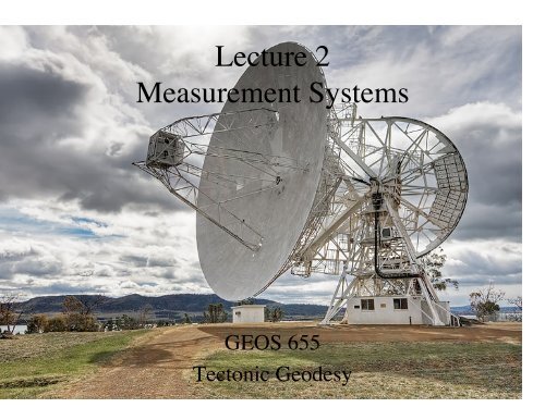
Lecture 2<strong>Measurement</strong> SystemsGEOS 655Tectonic Geodesy
VLBI and SLRVLBI – Very Long BaselineInterferometrySLR – Satellite Laser Ranging
The VLBI CorrelatorLooked like a movie-version computer command center.Today the correlator is done in s<strong>of</strong>tware, and data can be digital streams
Quasar Radio Emissions Recorded• Quasar = “Quasi-stellarobject”• Each quasar emits a uniqueand time-varying radio signal• Radio emissions from quasarsrecorded– Several telescopes record samequasar at same time– Then re-orient and record adifferent quasar– Repeat• Recordings sent to specialcomputer called a correlator
Signals Filtered, Down-converted
Cross-correlation• Signals cross-correlated (spectral), 3 observables:– Phase delay (ambiguous but very precise)– Group delay (unambiguous)– Phase delay rate <strong>of</strong> change (unambiguous)
Very Long Baseline InterferometryVLBIGeometric Delayand rateδgS B )BaselineEarth surfaceδg B.S≡ τ ( t)= + Δτ( tc
Observation Equationδg B.S≡ τ ( t)= + Δτ( t)c• <strong>Measurement</strong>s to different quasars meandifferent direction vectors S.– Measure different components <strong>of</strong> B• Tau represents other path delays
Very Long Baseline InterferometryVLBIGeometric Delayand rateδgS B )BaselineEarth surfaceδg B.S≡ τ ( t)= + Δτ( tc
A Sample VLBI Baseline• Plot shows evolution <strong>of</strong>baseline length– Westford (Massachusetts)– Wettzell (southern Germany)• Note improvement inscatter over time• Baseline length is invariantto rotations <strong>of</strong> network =most precise measure
VLBI Site Velocities Circa 1995• No sites in formerSoviet Union, most <strong>of</strong>Africa• Poor southernhemisphere coverage• But sufficient to provethat plate motions over1980-1990 agreedwith NUVEL-1 modelToday there are a few more sites, but not many more – very expensive
VLBI in Alaska!• NASA developedsome Mobile VLBI<strong>systems</strong>, and evenbrought one to Alaska– Smaller dish (5m)– All fit in one trucktrailer– Shipped across Alaskain connex containers!
LunarSatelliteLaser RangingLLRSLRMeasuring Time PropagationMoonEarth
SLR Principles• Emit laser pulse; start clock• Photon detector stops clock on returnedpulse– Shorter-duration pulse = higher precision• No need for simultaneous observations,high-accuracy timing, just an accurate“stopwatch”• Many pulses sent for each orbit
SLR Principles
SLR Principles• In practice, a week’s data is used todetermine a weekly average position. Untilthe 2000s they used monthly solutions.• SLR satellites have very stable orbits, canestimate a single orbit for >10 years <strong>of</strong>observations• SLR very sensitive to geocenter, large-scalegravity field
SLR Compared to Plate ModelEarly 1990s results
Geodesy and NUVEL-1A• Geodetic plate motion rates in the 1980s wereabout 5-6% slower than the NUVEL-1 platemotion model predicted, but all in the samedirection.• The cause was an error in the magnetic timescale.When the timescale was updated in the early1990s, the anomaly used for NUVEL-1s magneticpr<strong>of</strong>iles was found to be about 6% older.• The plate motion model was recalibrated andgeodesy and geology were found to agree.
An Update on this Theme• Nazca–South Americamotion has sloweddown over the last 15Ma• Geodesy agrees withthe most recentgeologic time (~1million year average)Norabuena et al.
VLBI and SLR• Originally designed for measurement <strong>of</strong> crustalmotion• Today’s uses:– SLR: determination <strong>of</strong> geocenter– SLR: changes in earth’s gravity field (J2, etc).– SLR: tracking <strong>of</strong> some satellites– VLBI: earth rotation rate– VLBI: earth orientation in space– both: contribute to stable definition <strong>of</strong> reference frame• IAG services provide weekly solutions for ITRF– IVS for VLBI– ILRS for SLR
International Association <strong>of</strong> GeodesySpace Geodesy Services• International Earth Rotation and Reference SystemsService (IERS) (1988)• Intern. GNSS Service (IGS) (1994)• Intern. Laser Ranging Service (ILRS) (1998)• Intern. VLBI Service (IVS) (1999)• Intern. DORIS Service (IDS) (2003)• And more …• Unifying project: Global Geodetic Observing System(GGOS)http://www.iag-aig.org/
International Association <strong>of</strong> GeodesyOther Services• International Gravimetric Service• International Gravity Field Service• International Center for Earth Tide• Permanent Service for Mean Sea Level• Time Section <strong>of</strong> the International Bureau <strong>of</strong>Weights and Measures• IAG Bibliographic Service http://www.iag-aig.org/
Global Positioning SystemGPSSatelliteEarthGPS AntennaNavigation Message sent by eachsatellite:- Orbit parameters- Clock correctionsGPS <strong>Measurement</strong>s:- Pseudorange- Phase
IGS Current Network
IGS = International GNSS Service• IGS coordinates operation <strong>of</strong> global satellitetracking network• IGS provides– Daily and weekly coordinate solutions– Daily and weekly precise orbit products– Estimates <strong>of</strong> earth orientation/rotation• IGS Central Bureau– http://www.igs.org run by JPL• Several projects (ionosphere estimates, GPS attide gauges, precise time transfer, etc.)
IGS Orbit Quality• Orbit quality improved from 20 cm in 1993to 2-3 cm since 2004, approaching 1-2 cm.
Rapid Orbit Quality (1 day)• Accuracy today < 2-3 cm.
Rapid Orbit Quality (3 hours)• Accuracy today < 5 cm.
The IGS as an Official ServiceFull exploitation <strong>of</strong> signal• Exceptionally high TEC values observed by IGS on October 29, 2003
The IGS as an Official ServiceFull exploitation <strong>of</strong> signal• Mean TEC was high, but not extraordinary on Oct 29, 2003.
Getting IGS Data and Products• 8 IGS Analysis Centers– 4 in USA: NGS, JPL/NASA, UC San Diego, MIT• 4 IGS Global Data Centers: Raw data, orbits,clocks, troposphere, ionosphere– UC San Diego (SOPAC, sopac.ucsd.edu)– NASA/CDDIS (cddis.gsfc.nasa.gov)– Institute Geographique National, France(igs.ensg.ign.fr)– Korean Astronomical and Space Institute(gdc.kasi.re.kr)


