the coolidge range summer recreation trails - Vermont State Parks
the coolidge range summer recreation trails - Vermont State Parks
the coolidge range summer recreation trails - Vermont State Parks

Create successful ePaper yourself
Turn your PDF publications into a flip-book with our unique Google optimized e-Paper software.
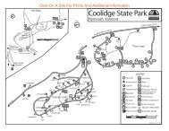
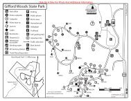
HikingThere are more than 30 miles of maintainedhiking <strong>trails</strong> on public land in <strong>the</strong> Coolidge Rangearea. Trails are identified with colored rectangularblazes. There are also many miles of woods roadsfor walking and exploring.1. Shrewsbury Peak Trail (1.8 miles to Shrewsbury Peak, 4.0 milesto Long Trail) Blue blazes. This trail links <strong>the</strong> CCC Road with <strong>the</strong>Long Trail near Little Killington Peak. It begins at <strong>the</strong> Russell Hillparking lot on CCC Road and ascends steeply to Shrewsbury Peak.There are remnants of Civilian Conservation Corps-era constructionincluding <strong>the</strong> pavilion chimney, wishing well and Russell Hill leanto.The trail begins in nor<strong>the</strong>rn hardwood forests but enters spruce-firforests at higher elevations. Views to <strong>the</strong> south and east from <strong>the</strong> peakinclude Plymsbury wetlands and Saltash Mountain. Elevation change:2,340 to 3,500 feet.2. Bessenyey Trail (1.5 miles) Blue blazes. This is primarily a crosscountryski trail. However, this system of old skid roads can also beused as walking paths in <strong>the</strong> <strong>summer</strong>. Parking is available on OldPlymouth Road. The trail head is ¼ mile east along <strong>the</strong> town road onnorth side. Remnant Norway spruce plantations, lowland spruce-firforests and nor<strong>the</strong>rn hardwood forests can all be seen along this trail.Elevation change: 2,100 to 2,400 feet.3. Long Trail/Appalachian Trail White blazes. A section of <strong>the</strong>Appalachian Trail/Long Trail (AT/LT) runs through <strong>the</strong> CoolidgeRange. It enters <strong>the</strong> region near Governor Clement Shelter and leaveson <strong>the</strong> north slope of Killington Peak, continuing through privateand federal lands before <strong>the</strong> two <strong>trails</strong> diverge and <strong>the</strong> AT continueseast through Gifford Woods <strong>State</strong> Park. The trail travels throughhigh elevation nor<strong>the</strong>rn hardwoods and spruce-fir forests. There arespectacular views from <strong>the</strong> summit of Killington Peak accessed by <strong>the</strong>Killington Spur Trail (0.2 miles). (Elevation change: 3,300 to 4,235feet). For more detailed information on <strong>the</strong> AT/LT system refer to <strong>the</strong>Green Mountain Club’s Long Trail Guide.4. Sherburne Pass Trail (2.9 miles to Route 4) Blue blazes. Thisis <strong>the</strong> former route of <strong>the</strong> Long Trail between Pico Camp and Route4 at Sherburne Pass, and currently connects to <strong>the</strong> AT/LT at both itsnorth and south ends. The Pico Link (0.4 miles) leads to <strong>the</strong> summit ofPico Peak. This trail is on private land with a public access easement.Elevation change: 3,600 feet (Pico Camp) to 2,700 feet (Old Maine Jct).5. Kent Brook Trail (1 mile) Yellow blazes. This loop trail follows <strong>the</strong>perimeter of Gifford Woods <strong>State</strong> Park through a nor<strong>the</strong>rn hardwoodforest. Trail intersects <strong>the</strong> AT at <strong>the</strong> halfway point. Accessible from<strong>the</strong> park entrance; day fee charged during operating season.6. Gifford Woods Interpretive Trail (0.3 mile). This loop trail hasinterpretive exhibits exploring <strong>the</strong> natural and cultural history of <strong>the</strong>Gifford Woods old-growth forest. Accessible from <strong>the</strong> park entrance;day fee charged during operating season.7. Bucklin Trail (3.4 miles). Blue blazes. This popular side trail to <strong>the</strong>AT/LT begins at Brewer’s Corners on Wheelerville Road in Mendonand ascends <strong>the</strong> western flank of Killington Peak. It follows an oldlogging road for much of its length. The trail ends at an intersectionwith <strong>the</strong> Long Trail. Elevation change: 1,800 to 3,600 feet.8. Tinker Brook Trail (0.4 Miles to Tinker Brook gorge) Blue blazes.This trail begins at a sharp turn on <strong>the</strong> CCC Road in <strong>the</strong> Town ofPlymouth. This moderate hike along an old woods road leads to <strong>the</strong>Tinker Brook Shelter and <strong>the</strong> Tinker Brook Natural Area. The NaturalArea includes 65 acres of Hemlock-Red Spruce Forest on <strong>the</strong> rockyslopes of Tinker Brook Gorge. It is thought to be old growth withmany of <strong>the</strong> trees around 200 years old. Elevation change: 1,800 to2,000 feet.9. Black Swamp Trail (2.1 miles) Blue blazes. This trail begins at<strong>the</strong> Black Swamp parking area on <strong>the</strong> CCC Road and follows <strong>the</strong>gated Black Swamp Road to its end through hardwood forests. BlackSwamp, an important bear feeding area in spring, is to <strong>the</strong> nor<strong>the</strong>ast.From <strong>the</strong>re <strong>the</strong> trail ascends through spruce-fir forests to ShrewsburyPeak. This route is a more gradual ascent than <strong>the</strong> ShrewsburyPeak Trail. The Shrewsbury Peak Shelter is just below <strong>the</strong> summit.Elevation change: 2,400 to 3,500 feet.10. CCC Trail (1.5 miles) Blue blazes. Coolidge <strong>State</strong> Park.Start at <strong>the</strong> park entrance off Route 100A near a wooden bridgeleading to <strong>the</strong> site of a former picnic shelter. The trail leads steeplyuphill and connects to an old fire road that climbs moderately forapproximately ½ mile to an intersection. Straight ahead a spur trailleads to <strong>the</strong> lean-to loop and office. To <strong>the</strong> right <strong>the</strong> CCC Trail dropssteeply downhill through a hemlock grove, crosses a brook, and <strong>the</strong>ncontinues uphill for ½ mile to ano<strong>the</strong>r intersection where a spur trailon <strong>the</strong> left leads to <strong>the</strong> tent loop. The CCC Trail continues straightand winds steadily uphill for <strong>the</strong> final ½ mile before coming out at<strong>the</strong> Bradley Hill picnic shelter. The trail continues past <strong>the</strong> shelter andcomes out on <strong>the</strong> park road opposite a parking area and <strong>the</strong> entranceto <strong>the</strong> Slack Hill Trail. Day fee charged during operating season.Elevation change: 1,050 to 1,850 feet.11. Slack Hill Trail (2.5 miles) Blue blazes. Coolidge <strong>State</strong> Park.The Slack Hill Trail begins at <strong>the</strong> park office, climbing moderatelyfor <strong>the</strong> first ½ mile through hardwoods; <strong>the</strong>n a short steep sectioncontinues to a trail intersection. The trail on <strong>the</strong> right descends backto <strong>the</strong> park road just above <strong>the</strong> office. The main trail continues leftclimbing moderately for one mile before descending a short distanceto a vista located near <strong>the</strong> 2,174 foot summit of Slack Hill. On cleardays Mount Ascutney can be seen in <strong>the</strong> distance. The trail continuesalternately climbing and descending for ano<strong>the</strong>r mile to <strong>the</strong> day usearea parking lot. Day fee charged during operating season. Elevationchange: 1,550 to 1,850 feet.Forest Legacy EasementsPublic access easements are held by <strong>the</strong> <strong>State</strong> on private land forpublic <strong>recreation</strong>. Several properties adjacent to Coolidge Rangelands have <strong>the</strong>se easements. The public access easements arefunded through <strong>the</strong> <strong>Vermont</strong> Forest Legacy Program.Parking and Fee AreasSeveral improved parking areas as well as pull-offs along roadsand old log landings serve as parking for <strong>summer</strong> <strong>recreation</strong>activities. The CCC Road provides access for <strong>recreation</strong>al activitiesincluding fall foliage viewing and hunting, but is not maintainedfor automobiles in winter. Gifford Woods and Coolidge <strong>State</strong><strong>Parks</strong> have parking and modern facilities, and charge entry feesduring <strong>the</strong> operations season. Do not block gates or roadways.Off-Road Vehicles ProhibitedThe use of ATVs, dirt bikes, or any o<strong>the</strong>r motorized, off-roadvehicle is prohibited on <strong>the</strong>se lands, roads and <strong>trails</strong>.Killington Resort on <strong>State</strong> LandKillington/Pico Ski Resort Partners, LLCleases nearly 1,700 acres of Coolidge <strong>State</strong>Forest at Killington Resort and offersdownhill skiing, snowboarding, mountainbiking and hiking activities. The companycharges fees for use of <strong>the</strong>ir lifts andfacilities, and may control, limit or excludepublic use or access in certain situations.Pico Mountain operates on private landowned by <strong>the</strong> resort.Mountain Bikes and HorsesMountain bikes and horseback riding are allowed only on gravelsurfaced roads within Coolidge <strong>State</strong> Forest and gravel or pavedroads in state parks. Killington Resort has more than 30 milesof mountain bike <strong>trails</strong> (fees charged) within <strong>the</strong> ski lease areaof Coolidge <strong>State</strong> Forest; Pine Hill Park in nearby Rutlandoffers many miles of <strong>trails</strong> as well. Mountain bike <strong>trails</strong> are alsoavailable on <strong>the</strong> Green Mountain National Forest to <strong>the</strong> north inPittsfield, Stockbridge and Rochester.CampingPrimitive camping is permitted within <strong>the</strong> following guidelines:no permits are required for stays of less than 4 days or for groupsof less than 11 people; camping must be at least 100 feet from anystream or body of water, 200 feet from a trail or property line; andat least 1,000 feet from any traveled road. No camping is allowedwithin designated Natural Areas. Please practice “leave no trace”or “carry in carry out” camping techniques. There are 3 lean-toshelters available for overnight use (Russell Hill, Shrewsbury Peakand Tinker Brook). Gifford Woods and Coolidge <strong>State</strong> <strong>Parks</strong> offerdeveloped facilities for tent, RV, lean-to and cabin camping.Hunting, Fishing and TrappingThe Coolidge Range offers over 18,600 of acres of public land forhunting, fishing and trapping. This large acreage is well suited tohunting large game including white-tailed deer, black bear, andmoose. Ruffed grouse, snowshoe hare and turkey hunting is alsopopular. Several brooks offer fishing opportunities, primarily forbrook trout. These activities require a license from <strong>the</strong> <strong>Vermont</strong>Fish and Wildlife Deparment.Trail PartnersTrails in <strong>the</strong> Coolidge Range are managed and maintained byForests, <strong>Parks</strong> & Recreation with many partners, including <strong>the</strong>Green Mountain Club, Farm & Wilderness Foundation, Killington-Pico Ski Resort Partners, <strong>Vermont</strong> Association of Snow Travelers,Catamount Trail Association and <strong>the</strong> Shrewsbury Outing Club.Winter RecreationSnowmobiling, cross-country skiing and snowshoeing are popularwinter activities. There are 33 miles of groomed snowmobile<strong>trails</strong>. Cross-country skiers and snowshoers can ski along <strong>the</strong>Catamount Trail, bushwack to any area of <strong>the</strong> property, enjoy <strong>the</strong><strong>trails</strong> on a 600-acre block of non-motorized forest area, or share <strong>the</strong>miles of groomed snowmobile <strong>trails</strong>. The Coolidge Range WinterRecreation Guide has more detailed information on wintertimeactivities.For More InformationPlease contact <strong>the</strong> Agency of Natural Resources Rutland Northoffice located at 271 N Main St, Suite 215, Rutland, VT 05701, orcontact by phone at (802)786-0060. On <strong>the</strong> web at: www.vtfpr.org,www.vtfishandwildlife.com and www.vtstateparks.com.Natural AreasThere are four designated Natural Areas (NA) in <strong>the</strong> CoolidgeRange. Tinker Brook NA is characterized by a steep, rocky gorgethat supports old growth yellow birch and red spruce. ShrewsburyPeak NA and Mendon Peak NA consist of high elevation spruce-firforests. Gifford Woods NA encompasses an old-growth nor<strong>the</strong>rnhardwood forest.The Coolidge Range forms a “bridge” along <strong>the</strong> Green Mountainspine that connects blocks of Green Mountain National Forestland to <strong>the</strong> north and to <strong>the</strong> south. This large block of remotepublic land provides nearly endless opportunities for low intensity,dispersed <strong>recreation</strong>al activities including hiking, hunting, fishing,birding, primitive camping and cross-country skiing. Focusedparcels provide more intensive <strong>recreation</strong>al opportunities such asdown-hill skiing (Killington Resort) or snowmobiling. Severalnearby state parks offer developed camping and day use facilities.Coolidge <strong>State</strong> Forest and Plymsbury Wildlife Management Areaprovide access to more than 18,600 acres of state lands. Thearea is most noted for mountainous terrain, expansive forests andassociated wetlands. Elevations <strong>range</strong> between 1,900 and 4,235feet, and include a “high peaks” area containing Killington Peak(<strong>Vermont</strong>’s 2nd highest peak, 4,235’), Little Killington (3,939’),Shrewsbury (3,720’), Mendon (3,840’) and Smith (3,220’) peaks.This area, along with Gifford Woods <strong>State</strong> Park and Coolidge <strong>State</strong>Park is referred to as <strong>the</strong> ‘Coolidge Range.’Welcome to <strong>the</strong> Coolidge Range AreaTHE COOLIDGE RANGESUMMER RECREATION TRAILS GUIDECoolidge <strong>State</strong> ForestCoolidge <strong>State</strong> ParkGifford Woods <strong>State</strong> ParkPlymsbury Wildlife Management AreaThis brochure is available upon request in largeprint, Braille, and audio cassette. Vt TDD Relay(800)253-0191.Printed on recycled paper02/10 LT/ERP Department of Fish and Wildlife