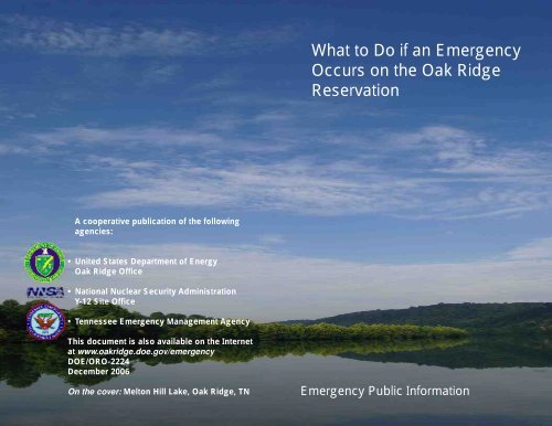
What To Do If An Emergency Occurs On - DOE Oak Ridge Operations
What To Do If An Emergency Occurs On - DOE Oak Ridge Operations
What To Do If An Emergency Occurs On - DOE Oak Ridge Operations
- No tags were found...

You also want an ePaper? Increase the reach of your titles
YUMPU automatically turns print PDFs into web optimized ePapers that Google loves.
ContentsHow Safe is the <strong>Oak</strong> <strong>Ridge</strong> Reservation?4Key <strong>Emergency</strong> Information5<strong>If</strong> You Hear the Sirens8<strong>If</strong> You Are Advised to Shelter-In-Place10<strong>If</strong> You Are Asked to Evacuate to Shelters11Evacuation Sector Maps and Shelters14<strong>Emergency</strong> Supplies Checklist37About Radiation38About Chemical Hazards40<strong>Oak</strong> <strong>Ridge</strong> Reservation Facilities4223
How Safe is the <strong>Oak</strong> <strong>Ridge</strong> Reservation?Key <strong>Emergency</strong> InformationThe Department of Energy (<strong>DOE</strong>)places its highest importance onthe safety of our employees andthe public while protecting theenvironment. Our missions arecomplex. They include cuttingedgescience, national security,environmental cleanup, and thenext generation of nuclear energytechnology.Our employees perform this workat three major sites spread across<strong>An</strong>derson and Roane counties,including the <strong>Oak</strong> <strong>Ridge</strong> NationalLaboratory (ORNL), the Y-12National Security Complex (Y-12),and the East TennesseeTechnology Park (ETTP)/HeritageCenter.FACTS: <strong>DOE</strong> in <strong>Oak</strong> <strong>Ridge</strong>• 13,000 employees• $2.7 billion budget• 33,725 acres• 1,456 buildingsDec. 2006Each site is unique. Some of ouroperations involve handlingradioactive and hazardousmaterials while others involvetearing down old industrialfacilities that are no longerneeded. <strong>What</strong>ever the task, wediligently strive to understand thehazards involved and take theproper precautions to protect ourworkers and the public.The risk of a major emergency,however, is very low. That’sbecause of extensive environment,safety and health programs inplace at our facilities to protect thehealth and safety of employeesand the public. That means that<strong>DOE</strong>, its contractors, and stateand local governments are trainedto respond to ensure public safetyand protection of the environmentif something happens.The following sections highlightactions you should take in theevent of an emergency along withbackground information on ourfacilities. Preparing makes sense,so take a moment to becomefamiliar with what you will need todo if an emergency occurs on the<strong>Oak</strong> <strong>Ridge</strong> Reservation.Gerald Boyd<strong>Oak</strong> <strong>Ridge</strong> OfficeManagerTed SherryY-12 Site OfficeManager<strong>What</strong> do I do when there is anemergency?<strong>DOE</strong> is committed to public safetyin the event an emergency arises.You will likely be made aware thatan emergency is happeningthrough the television or radioand, depending on the level ofemergency, the public warningsiren system.<strong>If</strong> an emergency is declared,trained responders are paged tothe site's <strong>Emergency</strong> <strong>Operations</strong>Center. Conditions are thenassessed to determine whatshould be done to protect thepublic and the environment. Withinan hour, a news release would beissued to the media stating that anemergency is in progress alongwith any protective actions thepublic should take asdirected by theTennessee <strong>Emergency</strong>Management Agency.Often these events areconfined to thebuilding or site and,therefore, impact onlythe employeesworking in theimmediate area.Should an event affectthe area beyond oursite boundaries,warning sirens locatedwithin two miles of the site wouldbe sounded. <strong>If</strong> you live in anaffected area, you may be askedto remain in your residence if youare at home, or you may be askedto change your route if you aredriving. When theseannouncements are made,specific instructions will be givenand will vary depending on whereyou live. The key is to stay tunedto the television and radio mediafor the latest information.The pages that follow describe thisprocess in detail. You will know thetypes of emergencies declared,some background on our facilities,and a map to locate where you liveand work. By the end of thispublication, you will know what todo if an emergency occurs on the<strong>Oak</strong> <strong>Ridge</strong> Reservation.<strong>Emergency</strong> Web site:www.oakridge.doe.gov/emergency45
Key <strong>Emergency</strong> InformationKey <strong>Emergency</strong> InformationHow We Notify the PublicFor less severe emergencies,when there is not a hazardousmaterials release or the release isnot causing a level of concern offthe <strong>Oak</strong> <strong>Ridge</strong> Reservation, newsreleases will be issued. Protectiveactions by the public may not benecessary.When there has been a release ofhazardous materials resulting in alevel of concern off the <strong>Oak</strong> <strong>Ridge</strong>Reservation, a combination ofresources is utilized to notify thepublic to take protective actions.These include the Public WarningSiren System and the <strong>Emergency</strong>Alert System.Categorization andClassification of EventsThe following describes howemergencies are classified at <strong>DOE</strong>facilities. These levels increase inseverity based on the emergency.You will hear these terms usedduring public announcements.Events that do not involve asignificant offsite release ofhazardous materials but requiresignificant response by the site,such as evacuation of buildingsand response by the FireDepartment, may be categorizedas an Operational <strong>Emergency</strong>.Events resulting in the airborne release of hazardous materials arefurther classified into one of three levels in order of increasing severity.The figure below provides a representation of the classification levels.Classifying the event into a severity level activates the needed resourcesfor the given condition.<strong>Emergency</strong> ClassificationAlertRelease PointSite Area<strong>Emergency</strong>Facilities<strong>On</strong>siteOffsiteGeneral<strong>Emergency</strong>AlertHarmful levels of release not exceeding the facility boundary.Site Area <strong>Emergency</strong>Harmful levels of release go beyond the building but are still onsite.General <strong>Emergency</strong><strong>Oak</strong> <strong>Ridge</strong> Protective ForceHarmful levels of release have either the potential to or have goneoffsite.Site is defined as the boundaries of either Y-12, ETTP or ORNL.67
<strong>If</strong> You Hear the Sirens<strong>If</strong> You Hear the SirensPublic Warning SirensSTATION NAMESTATION IDSirens are placed around each of the three sites to alert individualswithin an approximate two-mile area of each site. The sirens aredesigned to provide warning to the public. In the unlikely event that anemergency impacts the area beyond our reservation boundary,warning sirens located within 2 milesof the affected site will be sounded,and a steady wailing sound will beheard for three to five minutes.Upon hearing the sirens, immediatelygo inside a building or automobile andtune to a local radio or televisionstation for specific instructionsreceived over the <strong>Emergency</strong> AlertSystem (EAS). <strong>If</strong> you are on a lake ora river, leave the area by turning awayfrom the sirens and tune to a radiostation for specific instructionsbroadcast over the EAS.RadioWIVK (Primary - Knoxville)WNML (Knoxville)WOKI (Knoxville)TelevisionWATE (regional ABC affiliate)FM 107.7FM 99.1/AM 990FM 98.7WNOX (Knoxville) FM 100.3Channel 6<strong>Emergency</strong> Alert SystemThe EAS is a network of radio andtelevision stations on whichemergency instructions are providedto the public. The radio and televisionstations in the <strong>Oak</strong> <strong>Ridge</strong> area thatbroadcast EAS messages are listed on the following page. Warningmessages may also be sent over the weather alert radios.Protective ActionsPublic Warning Sirens aretested the first Wednesday ofeach month around noon.WBIR (regional NBC affiliate)WVLT (regional CBS affiliate)WTNZ (regional FOX affiliate)BBB Communications CableChannel 10Channel 8Channel 43Channel 12Protective actions are taken to avoid or minimize the exposure ofindividuals to the hazard. During emergencies, the local authoritiesmay direct the public to take protective actions. The two primaryprotective actions are to shelter-in-place or evacuate. These aredescribed in further detail on the following pages.<strong>If</strong> an emergency situation requires continuous updates to the public, a JointInformation Center will be opened for the media to obtain the latest informationfor broadcast to the public. A citizen's hotline may also be activated at(865) 362-8600 to answer questions from concerned citizens. Information mayalso be posted to the Internet at www.oakridge.doe.gov/emergency.89
<strong>If</strong> You Are Advised to Shelter-in-Place<strong>If</strong> You Are Asked to Evacuate to SheltersShelter-in-placeSheltering-in-place providesprotection from potential airbornehazardous materials that may havebeen released.<strong>If</strong> you are asked to shelter-in-placeat work or at home, follow theseinstructions:• Bring everyone inside (includingpets).• Close all doors and windows.• Turn off or close all ventilationsystems, including:• Air conditioning• Attic & exhaust fans• Furnaces• Fireplace dampers• Heating/cooling systems• Determine what sector you are in(see pages 14-15).• Continue to shelter-in-place andlisten to one of the EAS stations.• When the outside air is no longerdangerous, you will be instructedby the EAS that sheltering-inplacehas ended and to openand ventilate your home orbuilding.• Shelters may be opened forindividuals who cannot returnhome because a shelter-in-placehas been ordered for the area inwhich they live. <strong>If</strong> you areaffected in this manner, pleaselisten to EAS stations forannouncements of shelters beingopened or go to the home of afriend or relative that is outsidethe area of concern.Evacuation<strong>An</strong> evacuationmay beconducted whenthere is a concernthat hazardousmaterials mayimpact people in acertain area. <strong>If</strong> youare directed toevacuate fromyour home orwhile at yourworkplace, followthese guidelines:• Write down the evacuation routeand designated shelter providedover the EAS station. Theseinstructions will depend on whatsector you are currently in (seemap and shelter list on pages14-15 ) and what plant site isinvolved in the emergency.• <strong>If</strong> you do not have transportation,call a neighbor or co-worker forassistance. DO NOT CALL 911.• Keep your vehicle windowsclosed and turn off air systemsto eliminate the possible intakeof outside air into your vehicle.• Tune your vehicle’s radio to oneof the EAS stations listed onpage 9.• Secure your home or workplace.Before leaving home, tie a whitecloth or towel on your front doorto indicate to emergency officialsthat you have gone.• <strong>If</strong> you are at home, gather itemsyou will need for a short stayaway from home, such as:cellular phonemedicationstoiletriesspecial diet foodblankets & pillowscheckbookcredit cards<strong>Emergency</strong> Planningimportant papersa change of clothing10<strong>Oak</strong> <strong>Ridge</strong> <strong>Emergency</strong> <strong>Operations</strong> Center11
<strong>If</strong> You Are Asked to Evacuate to Shelters<strong>If</strong> You Are Asked to Evacuate to SheltersSpecial Needs<strong>If</strong> you or someone in yourhousehold has special needs,such as hearing or physicalimpairments that would preventtaking protective actions, contactthe local government serving yourresidence to submit a specialneeds request.For citizens in the city limits of <strong>Oak</strong><strong>Ridge</strong>, contact the <strong>Oak</strong> <strong>Ridge</strong>Police Department at 425-4399.For county residents, contact theidentified office in your respectivecounty: Roane County Sheriff’sDepartment at 354-8045,<strong>An</strong>derson County Sheriff’sDepartment at 457-2414, andLoudon County <strong>Emergency</strong>Management Agency Office at988-0175.Children inSchoolDuring anemergency,affected schoolswill be contactedimmediately bylocal officials.Your children willbe sheltered intheir school untilit is safe to leave.In the event of arelocation, yourchildren will beevacuated to apre-determined location, awayfrom the affected area by schoolofficials.<strong>Do</strong> not pick your children up fromtheir school or shelter until you aretold it is safe to do so.ETTP Two-Mile Sector (K) SchoolRelocationsSchools and daycares will relocateto Roane State CommunityCollege in Harriman.School administration will handle emergency actions attheir facilities.ORNL Two-Mile Sector (X)School RelocationsThere are no permanentresidences or schools located inthe ORNL Immediate NotificationZone, which is entirely within the<strong>DOE</strong> <strong>Oak</strong> <strong>Ridge</strong> Reservation.Y-12 Two-Mile Sector (Y) SchoolRelocationsSchools and daycares willrelocate to <strong>An</strong>derson County HighSchool in Clinton.<strong>If</strong> relocation is necessary forsectors beyond the two-mile area,relocation information will bereleased through mediabroadcasts.Special needs assistance is available through local governments.1213
Evacuation Shelters by SectorEvacuation Shelters by Sector2-mile Area5-mile AreaVVVVThe following pages show sectorson and around the <strong>Oak</strong> <strong>Ridge</strong>Reservation. Each sector has atleast one evacuation shelter.Shelters are opened based on thesite where the incident has occurredand the impacts of the event.SiteETTPORNLY-12SectorA B C D E F G H J K L M N P Q R S X YLC RS RS RS RS OR OR - - RS - - - - - - - OR -LC - - - - RS RS AC- RS - - - - KHS KHS LC KHS CHS- - - - - RS RS RS RS - AC AC CHS KHS KHS LC - LC ACAC - <strong>An</strong>derson County High School, CHS - Clinton High School, KHS - Karns High School, LC - Lenoir City High School, OR - <strong>Oak</strong> <strong>Ridge</strong> High School,RS - Roane State Community College (Harriman campus)14A dash in a sector’s box indicates that no action is required.15
Where the Shelters are Located<strong>An</strong>derson County High School130 Maverick CircleClinton, Tennessee 37716Where the Shelters are LocatedKarns High School2710 Byington Solway RoadKnoxville, Tennessee 37931Clinton High School425 Dragon DriveClinton, Tennessee 37716Lenoir City High School1485 Old Highway 95Lenoir City, Tennessee 37771<strong>Oak</strong> <strong>Ridge</strong> High School127 Providence Road<strong>Oak</strong> <strong>Ridge</strong>, Tennessee 37830Roane State CommunityCollege - Harriman Campus276 Patton LaneHarriman, Tennessee 377481617
Sector ASector BVVVVVVVVVVVRelocation Shelter for Sector A<strong>If</strong> there is an emergency at ETTP or ORNL requiring evacuation,Sector A reports to the shelter at:Lenoir City High School1485 Old Highway 95Lenoir City, Tennessee 37771Relocation Shelter for Sector B<strong>If</strong> there is an emergency at ETTP requiring evacuation,Sector B reports to the shelter at:Roane State Community College276 Patton LaneHarriman, Tennessee 37748Take most direct route to Highway 321. Travel on Highway 321 Southtoward Lenoir City to Old Highway 95. Travel for approximately 2 mileson Old Highway 95 to Lenoir City High School.Take most direct route to Interstate 40 westbound. Take Midtown Exit350 to Highway 70 West. Travel toward Rockwood for 7 miles to PattonLane. Turn right onto Patton Lane to Roane State Community College.1819
Sector ESector FVV VVVVVVVVVVVVVVRelocation Shelter for Sector ERelocation Shelters for Sector F<strong>If</strong> there is an emergency at ETTP requiring evacuation,Sector E reports to the shelter at:Roane State Community College276 Patton LaneHarriman, Tennessee 37748Take most direct route to Highway 27-61 southbound toward Rockwood.Turn left onto Patton Lane, approximately 2 miles after crossing underInterstate 40. Roane State Community College is on Patton Lane.<strong>If</strong> there is an emergency at ETTPrequiring evacuation, Sector Freports to the shelter at:<strong>Oak</strong> <strong>Ridge</strong> High School127 Providence Road<strong>Oak</strong> <strong>Ridge</strong>, Tennessee 37830Take most direct route tonorthbound <strong>Oak</strong> <strong>Ridge</strong> Turnpike to<strong>Oak</strong> <strong>Ridge</strong>. <strong>Oak</strong> <strong>Ridge</strong> High Schoolis on the left.<strong>If</strong> there is an emergency at ORNLor Y-12 requiring evacuation,Sector F reports to the shelter at:Roane State Community College276 Patton LaneHarriman, Tennessee 37748Take most direct route to Highway 27-61 southbound toward Rockwood.Turn left onto Patton Lane,approximately 2 miles after crossingunder Interstate 40. Roane StateCommunity College is on PattonLane.2223
VVVSector GSector HVVVW.VVW.VVVVVVRelocation Shelters for Sector GRelocation Shelters for Sector H<strong>If</strong> there is an emergency at ETTPrequiring evacuation, Sector Greports to the shelter at:<strong>If</strong> there is an emergency at ORNLor Y-12 requiring evacuation,Sector G reports to the shelter at:<strong>If</strong> there is an emergency at ORNLrequiring evacuation, Sector Hreports to the shelter at:<strong>If</strong> there is an emergency at Y-12requiring evacuation, Sector Hreports to the shelter at:<strong>Oak</strong> <strong>Ridge</strong> High School127 Providence Road<strong>Oak</strong> <strong>Ridge</strong>, Tennessee 37830Roane State Community College276 Patton LaneHarriman, Tennessee 37748<strong>An</strong>derson County High School130 Maverick CircleClinton, Tennessee 37716Roane State Community College276 Patton LaneHarriman, Tennessee 37748Take most direct route tonorthbound <strong>Oak</strong> <strong>Ridge</strong> Turnpike to<strong>Oak</strong> <strong>Ridge</strong>. <strong>Oak</strong> <strong>Ridge</strong> High Schoolis on the left.Take most direct route to Highway27-61 southbound towardRockwood. Turn left onto PattonLane, approximately 2 miles aftercrossing under Interstate 40. RoaneState Community College is onPatton Lane.Take most direct route to <strong>Oak</strong> <strong>Ridge</strong>Turnpike going east. Continue eastuntil road turns into Highway 61.Follow this northbound into Clinton.Turn left onto Maverick Circle to<strong>An</strong>derson County High School.Take most direct route to southbound<strong>Oak</strong> <strong>Ridge</strong> Turnpike. Then takewestbound Highway 58 (GallaherHighway) to I-40 westbound. Take Exit350 (Midtown) off I-40 to Highway 70,and travel toward Rockwood for 7 milesto Patton Lane. Turn right to Roane StateCommunity College.2425
Sector JSector KVVVVVW.VVW.VVRelocation Shelter for Sector J<strong>If</strong> there is an emergency at Y-12 requiring evacuation,Sector J reports to the shelter at:Roane State Community College276 Patton LaneHarriman, Tennessee 37748Relocation Shelter for Sector K<strong>If</strong> there is an emergency at ETTP or ORNL requiring evacuation,Sector K reports to the shelter at:Roane State Community College276 Patton LaneHarriman, Tennessee 37748Take most direct route to Highway 27-61 southbound toward Rockwood.Turn left onto Patton Lane, which is 2 miles after crossing under I-40.Roane State Community College is on Patton Lane.Take most direct route to Interstate 40 westbound. Take Midtown Exit350 to Highway 70 West. Travel toward Rockwood for 7 miles to PattonLane. Turn right onto Patton Lane to Roane State Community College.2627
W.Sector LSector MVVVVVVVVVVVVVVVVW.Relocation Shelter for Sector L<strong>If</strong> there is an emergency at Y-12 requiring evacuation,Sector L reports to the shelter at:<strong>An</strong>derson County High School130 Maverick CircleClinton, Tennessee 37716Relocation Shelter for Sector M<strong>If</strong> there is an emergency at Y-12 requiring evacuation,Sector M reports to the shelter at:<strong>An</strong>derson County High School130 Maverick CircleClinton, Tennessee 37716Take most direct route to State Route 61 northbound to Clinton. Turn leftonto Maverick Circle to <strong>An</strong>derson County High School.Take most direct route to State Route 61 northbound to Clinton. Turn leftonto Maverick Circle to <strong>An</strong>derson County High School.2829
Sector NSector PVVVVVVVVVVRelocation Shelter for Sector N<strong>If</strong> there is an emergency at Y-12 requiring evacuation,Sector N reports to the shelter at:Clinton High School425 Dragon DriveClinton, Tennessee 37716Relocation Shelter for Sector P<strong>If</strong> there is an emergency at Y-12 requiring evacuation,Sector P reports to the shelter at:Karns High School2710 Byington Solway RoadKnoxville, Tennessee 37931Take most direct route to <strong>Oak</strong> <strong>Ridge</strong> Turnpike (Highway 95) going east.Continue east until road turns into Highway 61. Follow this northboundinto Clinton. Turn left onto Hillcrest St., then right onto Dragon Drive toClinton High School.Take most direct route to State Route 62 (<strong>Oak</strong> <strong>Ridge</strong> Highway)eastbound to Knoxville. Turn right (south) onto State Route 131(Byington Beaver <strong>Ridge</strong>) to Byington Community to Karns High School.3031
Sector QSector RVVVVVVVRelocation Shelter for Sector QRelocation Shelters for Sector R<strong>If</strong> there is an emergency at ORNL or Y-12 requiring evacuation,Sector Q reports to the shelter at:Karns High School2710 Byington Solway RoadKnoxville, Tennessee 37931<strong>If</strong> there is an emergency at ORNLrequiring evacuation, Sector R reportsto the shelter at:Karns High School2710 Byington Solway RoadKnoxville, Tennessee 37931<strong>If</strong> there is an emergency atY-12 requiring evacuation,Sector R reports to the shelter at:Lenoir City High School1485 Old Highway 95Lenoir City, Tennessee 3777132Take most direct route to State Route 62 (<strong>Oak</strong> <strong>Ridge</strong> Highway)eastbound to Knoxville. Turn right (south) onto State Route 131(Byington Beaver <strong>Ridge</strong>) to Byington Community to Karns High School.Take most direct route to Hardin ValleyRoad eastbound. Then turn left ontoState Route 131 to the ByingtonCommunity to Karns High School.Take most direct route to Interstate75 southbound toward Lenoir City.Take Exit 81 (Lenoir City) to Highway321 into Lenoir City. Turn right ontoMcGee Boulevard for about 6/10mile to Kingston Street. Turn righton Kingston Street for 2 miles toLenoir City High School.33
VSector SSector XVVVVVVVVVVVVVVVVVVV34Relocation Shelter for Sector S<strong>If</strong> there is an emergency at ORNL requiring evacuation,Sector S reports to the shelter at:Lenoir City High School1485 Old Highway 95Lenoir City, Tennessee 37771Take most direct route to Interstate 75 southbound toward Lenoir City.Take Exit 81 (Lenoir City) to Highway 321 into Lenoir City. Turn right(west) onto McGee Boulevard for about 6/10 mile to Kingston Street.Turn right (north) on Kingston Street for 2 miles to Lenoir City HighSchool.Relocation Shelters for Sector X<strong>If</strong> there is an emergency at ETTP requiring evacuation, Sector X reports to the shelter at:<strong>Oak</strong> <strong>Ridge</strong> High School127 Providence Road<strong>Oak</strong> <strong>Ridge</strong>, TN 37830<strong>If</strong> there is an emergency at ORNL requiring evacuation, Sector X reports to the shelter at:Karns High School2710 Byington Solway RoadKnoxville, TN 37931<strong>If</strong> there is an emergency at Y-12 requiring evacuation, Sector X reports to the shelter at:Lenoir City High School1485 Old Highway 95Lenoir City, TN 37771Take most direct route to northbound Bethel ValleyRoad toward <strong>Oak</strong> <strong>Ridge</strong>. Turn left onto Illinois Avenue(Highway 62). Turn right onto <strong>Oak</strong> <strong>Ridge</strong> Turnpike andturn left to <strong>Oak</strong> <strong>Ridge</strong> High School.Take most direct route to northbound Bethel Valley Roadtoward Knoxville. Then take a left at Highway 62(<strong>Oak</strong> <strong>Ridge</strong> Highway) eastbound to Knoxville. Take aright onto State Route 131 (Byington Beaver <strong>Ridge</strong>) toKarns High School.Take most direct route to State Route 95 southboundtoward Lenoir City. Then to Highway 321 towardLenoir City. Then travel south on Old Highway 95 for twomiles to Lenoir City High School.17 35
Sector Y<strong>Emergency</strong> Supplies ChecklistVVVV<strong>To</strong> help you prepare for any type of emergency, we haveprovided two lists of supplies.The first contains items you may need to keep in your home toaid in response to any emergency. The second contains suppliesto take with you if you are asked to evacuate. Add any additionalsupplies that you need. You may desire to prepare an overnightbag in case of an emergency. <strong>If</strong> you are evacuating with a pet,please ensure you transport your pet in a carrier with plentyof food and water.<strong>Emergency</strong> supplies for your home:Relocation Shelters for Sector Y<strong>If</strong> there is an emergency at ORNLrequiring evacuation, Sector Yreports to the shelter at:Clinton High School425 Dragon DriveClinton, Tennessee 37716Take most direct route to <strong>Oak</strong> <strong>Ridge</strong>Turnpike (Highway 95) going east.Continue east until road turns intoHighway 61. Follow this northbound intoClinton. Turn left onto Hillcrest Street,then right onto Dragon Drive to ClintonHigh School.<strong>If</strong> there is an emergency at Y-12requiring evacuation, Sector Yreports to the shelter at:<strong>An</strong>derson County High School130 Maverick CircleClinton, Tennessee 37716Take most direct route to <strong>Oak</strong> <strong>Ridge</strong>Turnpike going east. Continue eastuntil road turns into Highway 61.Follow this northbound into Clinton.Turn left onto Maverick Circle to<strong>An</strong>derson County High School.• This booklet• First aid kit• <strong>To</strong>olbox• Candles and matches• Portable radio• Flashlight• Extra batteries• Food and waterEvacuation supplies:• This booklet• Medicine and all prescriptions• Personal health products (shaving cream, deodorant, andtoothbrush)• Special diet food and supplies• Food and water• Blankets and pillows or sleeping bag• Cash, checkbook, credit cards, important papers• Items for baby (diapers, formula, clothing)• Items for children (toys, books, clothing)• Change of clothing• Cellular phone3637
About RadiationAbout Radiation<strong>What</strong> is radiation?Radiation is a form of energy thatis a part of our everyday lives. Allof us receive a "dose" of radiationeach day. Most of the dosecomes from naturally occurringradioactive materials such asuranium, thorium, radon, andcertain forms of potassium andcarbon. The air we breathecontains radon, the food we eatcontains uranium and thoriumfrom the soil, and our bodiescontain radioactive forms ofpotassium and carbon. Cosmicradiation from the sun alsocontributes to our naturalradiation dose.We also receive radiation dosesfrom man-made sources such asX-rays, nuclear medicalprocedures, power plants, smokedetectors and older televisionsets. Some people, such asnuclear plant operators, flightcrews, and nuclear medicine staffmay also receive an occupationalradiation dose.Measuring <strong>Do</strong>seRadiation doses are normallymeasured in a unit called the rem.The dose is based both on theamount of radiation received byan individual and the biologicaleffect associated with the particulartype of radiation. Since ourradiation doses are normally verysmall, we usually record the dosein millirem (mrem). <strong>On</strong>e remequals 1,000 mrem.Most of us receive about 360mrem a year from the radioactivesources listed above. About 300mrem comes from natural sources,and the other 60 mrem from manmadesources. <strong>To</strong> put this inperspective, the average dosefrom a chest X-ray is about 10mrem, and we get about 3 mremwhen we make a cross countryflight.The <strong>DOE</strong> has established a 100-millirem dose limit to members ofthe public from exposure pathwaysthat are the result of its operations.The maximum dose any memberof the public could have possiblyreceived from normal operationson the <strong>Oak</strong> <strong>Ridge</strong> Reservation in2004 was 12 mrem. This includeseating deer, turkey, fish, and geeseharvested on or near theReservation; drinking the mostcontaminated water; and breathingthe most contaminated air. It isvery unlikely any one person couldhave actually received this dose.Types of RadiationYou may be familiar with some ofthe common types of radiation:alpha and beta particles, gammarays and neutrons. Alpha andbeta particles are usuallyhazardous only if inhaled oringested. Gamma rays andneutrons can penetrate the bodyfrom the outside. All radioactivematerials emit at least one ofthese radiations. <strong>If</strong> a nuclearemergency occurs in <strong>Oak</strong> <strong>Ridge</strong>,it is not necessary to rememberthe differences in the types ofradiation, since all of the typescould be encountered.Levels of RadiationA Nuclear <strong>Emergency</strong> in <strong>Oak</strong><strong>Ridge</strong>?While it is possible that a nuclearemergency impacting the <strong>Oak</strong><strong>Ridge</strong> area could occur, it is notlikely. <strong>If</strong> there is a nuclearemergency, most members of thepublic would not be expected toreceive a radiation dose. For thosepeople who did, the averagedoses would be expected to beless than the 360 mrem the publicreceives each year.Gastrointestinal series (upper and lower)..................... 1400 milliremCT scan (head and body)............................................... 1100 milliremRadon in average household......................................... 200 millirem/yearPlutonium-powered pacemaker..................................... 100 millirem/yearNatural radioactivity in our body.................................... 40 millirem/yearCosmic radiation............................................................. 31 millirem/yearMammogram................................................................... 30 milliremSmoking cigarettes (1 pack/day)................................... 15-20 millirem/year*Maximum possible from normal operations on the<strong>Oak</strong> <strong>Ridge</strong> Reservation................................................... 12 millirem/yearConsumer products........................................................ 11 millirem/yearChest X-ray...................................................................... 10 milliremDental X-ray..................................................................... 10 milliremUsing natural gas in the home....................................... 9 millirem/yearRoad construction materials.......................................... 4 millirem/yearLiving near a nuclear power station............................... 1 millirem/yearAir travel (every 2000 miles)........................................... 1 millirem38*Source, 2004 <strong>DOE</strong> <strong>An</strong>nual Site Environmental Report Summary39
About Chemical HazardsAbout Chemical Hazards<strong>What</strong> Is a Chemical Hazard?A chemical hazard is anysubstance that can cause harm,primarily to people. Chemicals ofall kinds are stored in our homesand can result in serious injuries ifnot properly handled. Householditems such as bleach can result inharmful chlorine gas orhydrochloric acid if carelesslyused. Gasoline fumes fromcontainers for lawnmowers orboats can result in major healthhazards if inhaled.• Acetronitrile• Acids• Asbestos• Beryllium• Cadmium• Cyanide compounds• Hydrogen Chloride• Hydrogen Fluoride<strong>DOE</strong> <strong>Oak</strong> <strong>Ridge</strong> uses thousands ofchemicals in its varied researchand other operations. Newchemicals are or can be created asa result of the research or otheractivities. <strong>DOE</strong> follows nationalsafety requirements in storing andhandling these chemicals tominimize the risk of injuries from itschemical usage. However,accidents can occur despite carefulattention to proper handling andstorage procedures.Types of Chemicals Used at the <strong>Oak</strong> <strong>Ridge</strong> Facilities• Lead• Lithium compounds• Mercury• Methylene Chloride• Nickel• PCBs• Sodium• UraniumA federal law called the <strong>Emergency</strong> Planning and Community Right toKnow Act gives you the right to know about toxic chemicals beingreleased into the environment. The <strong>To</strong>xics Release Inventorymaintained by the U.S. Environmental Protection Agency providesinformation about the types and amounts of toxic chemicals that arereleased each year to the air, water, and land as well as informationon the quantities of toxic chemicals sent to other facilities for furtherwaste management.Data for Department of Energy facilities in <strong>Oak</strong> <strong>Ridge</strong> is included inthis Inventory. You can view this information at the Web sitewww.epa.gov/tri. By entering the <strong>Oak</strong> <strong>Ridge</strong> zip code "37831" at theprompt, you can view information on the types of chemicals used atthe <strong>DOE</strong> facilities.Chemical <strong>Emergency</strong> in<strong>Oak</strong> <strong>Ridge</strong><strong>DOE</strong> <strong>Oak</strong> <strong>Ridge</strong> has dozens offacilities engaged in chemicaloperations. Most operations involvesuch small quantities of chemicalsthat an accident poses little threat topeople. However, <strong>DOE</strong> also hassome larger chemical operationsand, in some locations, largeramounts of stored chemicals whereworkers and the public can beimpacted by accidents.While accidents are possible, <strong>DOE</strong>believes the risk of exposure to itsworkers is low due to the safetyprecautions followed throughout the<strong>DOE</strong> <strong>Oak</strong> <strong>Ridge</strong> Reservation. Therisk to the public from harmfulLaboratory testing activitiesbeing released outside of the <strong>DOE</strong>property areas is even lower. In theevent of a chemical release with thepotential for off-site impacts, thesirens will sound and a messagewill be broadcast on the<strong>Emergency</strong> Alert System.However, as a matter of simpleprudence and for compliance withFederal government safetyrequirements, <strong>DOE</strong> has preparedemergency response plans foraccidents that could occur. <strong>DOE</strong>and its contractors maintain anexperienced group of emergencyresponse personnel trained torespond to chemical accidents.4041
East Tennessee Technology ParkEast Tennessee Technology ParkThe EastTennesseeTechnologyPark wasoriginallynamed “The<strong>Oak</strong> <strong>Ridge</strong>GaseousDiffusionPlant.” Aspart of theManhattanProject, thePlant was designed to produceenriched uranium for use inatomic weapons operationsduring World War II.East Tennessee Technology ParkAfter the war, this Plant wasrenamed the <strong>Oak</strong> <strong>Ridge</strong> K-25Site and produced enricheduranium for the commercialnuclear power industry from1945 to 1985. In 1987, <strong>DOE</strong>renamed the site the EastTennessee Technology Park(ETTP) and began a majorenvironmental cleanup projectwith the long-term goal ofFACTS: ETTP• Sector K• Located approximately 13 mileswest of downtown <strong>Oak</strong> <strong>Ridge</strong> offHighway 58 in Roane County• 2,400 employees• 640 acres• www.bechteljacobs.com• www.croet.comindustrial park called HeritageCenter. Cleanup activities arebeing conducted by BechtelJacobs Company. As cleanup iscompleted, <strong>DOE</strong> transfersownership of the uncontaminatedbuildings to the Community ReuseOrganization of East Tennessee(CROET), who in turn leases thisproperty for immediate privateindustrial use.Some of the key facilities include:TSCA IncineratorETTP is home to the <strong>DOE</strong> <strong>To</strong>xicSubstances Control Act (TSCA)Incinerator off Blair Road, the onlyU.S. facility permitted to burncertain radioactive and/orhazardous wastes. TheIncinerator treats both solid andliquid wastes originating from <strong>DOE</strong>sites.The Incinerator is located on theIncinerator operator develops andfollows detailed procedures toensure safety and compliance withrules and regulations issued by<strong>DOE</strong>, the EnvironmentalProtection Agency, and the Stateof Tennessee.Periodic tests and evaluations areconducted to ensure performancemeets requirements. A burn plandetailing what waste will be treatedis av ailable on the Web sitehttp://www.bechteljacobs.com/tsca.K-25/27 Demolition ProjectThe U-shaped K-25 Building isapproximately one mile long andhas 44 acres under one roof. Thebuilding is near the center of ETTPand was built in 1943. The K-27Building is a rectangular buildingthat is approximately 374,000square feet. It was built in 1945.Except for the shape and size, thetwo buildings are very similar inconstruction and materials.Both buildings contain radioactivecontamination and hazardousmaterials in the building structuresand plans are to demolish them.Main PlantMost facilities at ETTP, exceptthose designated for reuse, havebeen, or are scheduled to be,demolished as part of <strong>DOE</strong>’sEnvironmental Cleanup Program.Approximately 500 above-groundfacilities, including buildings,tanks, sheds, and other structureshave been demolished. Mosthave actual or potential elevatedconcentrations of radiologicaland/or other hazardoussubstances. Several largeindustrial buildings at the site willbe demolished within the next twoyears.More than 150 facilities, includingthe former administration building,cafeteria, and medical facility, havealready been demolished. Otherbuildings, including K-1225,K-1330, K-1007, K-1580, K-1036,and K-1400, have been transferredto CROET for reuse by privateindustry.TSCA Incinerator4243
<strong>Oak</strong> <strong>Ridge</strong> National Laboratory<strong>Oak</strong> <strong>Ridge</strong> National LaboratoryThe <strong>Oak</strong> <strong>Ridge</strong> NationalLaboratory (ORNL) is <strong>DOE</strong>'slargest multipurpose sciencelaboratory and is managed by UT-Battelle LLC. ORNL wasestablished in 1943 as a part of theManhattan Project and wasformerly known as the X-10 site.<strong>To</strong>day, ORNL is an internationalleader in a range of scientific areasthat support <strong>DOE</strong>’s mission in theOffice of Science. TheLaboratory’s six major scientificcompetencies include neutronscience, energy, high performancecomputing, complex biologicalsystems, advanced materials, andnational security.Spallation Neutron SourceThis one-of-a-kind facility was builton Chestnut <strong>Ridge</strong> by apartnership of six<strong>DOE</strong> laboratoriesto provide the mostintense pulsedneutron beams inthe world forscientific researchand industrialdevelopment.Neutron researchat the SpallationNeutron Sourcehelps researchersimprove materialsFACTS: ORNL• Sector X• Located on Bethel ValleyRoad in the Roane Countysection of <strong>Oak</strong> <strong>Ridge</strong>• 4,000 employees and 3,000guest researchers annually• 4,470 acres• www.ornl.govused in high-temperaturesuperconductors, powerfullightweight magnets, aluminumbridge decks, and stronger,lighter plastic products. Thisresearch has already led toimproved shatter-proofwindshields, pocket calculators,adjustable seats, and moreaccurate satellite weatherforecast information.High Flux IsotopeReactorThe High FluxIsotope Reactor(HFIR) began fullpoweroperations in1966 and is one ofthe world's mostpowerful researchreactors.<strong>On</strong>e of the originalprimary purposes ofthe HFIR was the production ofcalifornium-252 and othertransuranium isotopes for research,industrial, and medicalapplications. <strong>To</strong>day, the principaluse of HFIR is for neutron physicsresearch.Radiochemical EngineeringDevelopment Center - Building7920Since the mid-1960s, theRadiochemical EngineeringDevelopment Center (REDC) hasbeen the production, storage, anddistribution center for the heavyelementresearch program of <strong>DOE</strong>.This includes work with transuranicelements, such as neptunium,americium, and californium. Theseelements are used in a number ofapplications, including medicalresearch and industry.High Flux Isotope ReactorThe heart of the REDC is a batteryof nine heavily shielded hot cellshoused in a two-story building. Ofthe nine cells, four containchemical processing equipmentfor dissolution, solvent extraction,ion exchange, and precipitationoperations. Three containequipment for the preparation andinspection of transuranic elementtargets, while one cell is used foranalytical chemistry operations,and another is used for wastecollection and sorting.Transuranic (TRU) Waste FacilityThe Transuranic Waste ProcessingCenter is managed by EnergX onbehalf of Foster Wheeler. The siteis located on 5.2 acres of land offHighway 95.Spallation Neutron Source4445
<strong>Oak</strong> <strong>Ridge</strong> National Laboratory<strong>Oak</strong> <strong>Ridge</strong> National LaboratoryThe TWPC mission is to receivelegacy TRU wastes and futurewastes to be generated fromdecontamination anddecommissioning, remediation,and ongoing mission operationsat the ORNL complex. The facilityprocesses, treats, repackages andships the waste for final disposalat the Waste Isolation Pilot Plant,Nevada Test Site, or any otherdesignated disposal facility.The site is the only facility of itstype in the region specificallydesigned to accomplish thismission. Low-level and low-levelmixed wastes generated as abyproduct of TRU processoperations are also processed forshipment to the Nevada Test Siteor other appropriate disposalfacility.Molten Salt Reactor ExperimentFacilityThe Molten Salt ReactorExperiment (MSRE) operated atORNL from 1965 to 1969. Itspurpose was to test an alternativeconcept for powering a nuclearreactor. Rather than using fuelrods to contain the radioactivesource, as do today's commercialpower reactors, the MSREpumped a mixture of radioactivemolten salt through a series ofpipes to generate heat and powerthe reactor.When the reactor was shut down,the fuel salt was drained into twolarge metal tanks. A flush salt wasthen circulated through the tankand drained into a third storagetank. In late 1994, researchersdetected thatradioactivematerial hadtraveled from thestorage tanksinto pipesconnected to thedrain tanks. Thematerial wasremoved fromthe pipes, and<strong>DOE</strong> is nowplanning theremoval of fuelsalts from thedrain tanks.<strong>An</strong> expected nine metric tons ofmaterial will be removed from thetanks and transported to astorage facility at ORNL, where itwill await final disposal at anappropriate site.Radiochemical DevelopmentFacility - Building 3019Building 3019 is one of thenation's few repositories foruranium-233 (U-233) and otherspecial nuclear materials, with ahistory dating back to theManhattan Project. Located nearthe center of the ORNL campus,3019 is where the majority of thenation's separated U-233 isstored.U-233 is an alpha-particle emitter,similar to the better-knownisotope, U-235. Associated withthe U-233 and regarded as acontaminant is U-232. Thisuranium isotope emits high-energygamma radiation that requiresextensive shielding to protectworkers.Transuranic Waste FacilityORNL Fire Protection4647
Y-12 National Security ComplexSee Map and Remember...Y-12 National Security ComplexThe focus of the Y-12 NationalSecurity Complex (Y-12) is theproduction and refurbishment ofweapons components, storage ofnuclear material and prevention ofthe spread of weapons of massdestruction. Y-12 is managed byBWXT Y-12 LLC for the NationalNuclear Security Administration.Y-12 has five primary missions:• Producing, refurbishing anddismantling nuclear weaponscomponents;• Safeguarding special nuclearmaterials;• Preventing the proliferation ofweapons of mass destruction;• Providing the U.S. Navy withsafe, effective nuclear propulsionsystems; and• Providing support for othernational security needs andcustomers, as required.Built between twomountain ridges, the Y-12(previously Y-12 Plant)mission was to processuranium for the first atomicbomb. Construction of Y-12 began in February1943; enriched uraniumproduction began inNovember 1943.Construction, however,was not finished until 1945.After World War II, Y-12evolved into a high-precisionmanufacturing, assembly andinspection facility whilemaintaining the nation's uraniumand lithium technology base.Every weapon in the stockpilehas some componentsmanufactured at Y-12.FACTS: Y-12• Sector Y• Located on 800 acres in<strong>An</strong>derson County off BearCreek Road• 2-½ miles long x ½ mile widecomplex• 4,500 BWXT Y-12 employees• 80 NNSA employees• 500 buildings• 7 million square feet of floorspace on 811 acres• www.y12.doe.govI live in Sector:_____________I work in Sector:____________Evacuation Locations for my Children’s Schools:__________________________For More Information:• <strong>DOE</strong> <strong>Oak</strong> <strong>Ridge</strong> Office Public Affairs(865) 576-0885• NNSA Y-12 Site Office Public Affairs(865) 576-9918• Tennessee <strong>Emergency</strong> Management Agency1-800-533-7343This brochure is available on the <strong>DOE</strong> <strong>Emergency</strong>Communications Web Site at:http://www.oakridge.doe.gov/emergencyCopies may also be obtained at:The <strong>DOE</strong> Information Center475 <strong>Oak</strong> <strong>Ridge</strong> Turnpike<strong>Oak</strong> <strong>Ridge</strong>, Tennessee 37830(865) 241-478048