We 'n' Our Society - 6.pdf - School Books Publishers India
We 'n' Our Society - 6.pdf - School Books Publishers India
We 'n' Our Society - 6.pdf - School Books Publishers India

You also want an ePaper? Increase the reach of your titles
YUMPU automatically turns print PDFs into web optimized ePapers that Google loves.
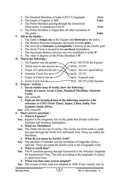
3. The Standard Meridian of <strong>India</strong> is 82½º E longitude. True4. The length of Equator is 360º. False5. The Prime Meridian passing through the GreenwichObservatory is considered to be 0º.True6. The Prime Meridian is longer than all other meridians ofthe globe.FalseC. Fill in the blanks :1. The Earth is bulges out at the Equator and flattened at the poles.2. The distance between longitudes decreases towards poles.3. The network of latitudes and longitudes is known as the Earth's grid.4. The Arctic Circle is located in the northern hemisphere.5. The maximum distance between any two meridians is at the 0°.6. The value in degrees of the Prime Meridian is 0º.D. Match the following :1. The Equator cuts the globe (a) 66½ºS fo the Equator2. Torrid zone is also known as (b) 23½ºN3. Tropic of Capricorn lies at (c) into two equal halves4. Antarctic Circle lies at (d) 23½ºS5. Tropic of Cancer lies at (e) Tropical zone6. Arctic Circle lies at (f) 66½ºN of the Equator.E. Project / Activity :1. On an outline map of world, show the following :Tropic of Cancer, Arctic Circle, Standard Meridian, AntarcticCircle.Ans. (Do yourself)2. Find out the Standard time of the following countries withreference to GMT (Noon Time): Japan, China, <strong>India</strong>, NewZealand, South Africa.Ans. (Do yourself)F. Short answer questions :1. What is Equator?Ans. Equator is the imaginary line on the globe that divides earth intoNorthern and Southern Hemisphere.2. What are Meridians?Ans. The Globe has two set of circles. The circles run from north to southand pass through the North Pole and South Pole. These are called theMeridians.3. What do you mean by Earth's Grid?Ans. The parallels of latitudes and the meridians of longitudes form anetwork. These are called the Earth's Grid or the Geographic Grid.4. What is world time?Ans. The 0º meridian passing through Greenwich is the reference longitudefor International Time. The time according to the longitude of a placeis called local time.5. When was time zone system adopted?Ans. The system of time zone was adopted in 1884. Every country sets its6Horizon Press <strong>We</strong> <strong>'n'</strong> <strong>Our</strong> <strong>Society</strong> – 6

![Enjoy with Social Life-4 [74-105] - School Books Publishers India](https://img.yumpu.com/49489719/1/166x260/enjoy-with-social-life-4-74-105-school-books-publishers-india.jpg?quality=85)


![Enjoy with Social Life-2 [26-50] - School Books Publishers India](https://img.yumpu.com/44509443/1/166x260/enjoy-with-social-life-2-26-50-school-books-publishers-india.jpg?quality=85)