Grande Cache Guide
Grande Cache Guide
Grande Cache Guide

Create successful ePaper yourself
Turn your PDF publications into a flip-book with our unique Google optimized e-Paper software.
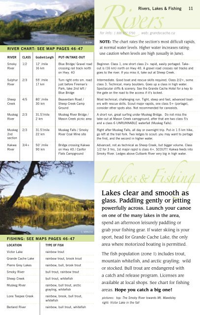
Rivers, Lakes & Fishing 11Riversfor info: 1 888 827 3790 web: grandecache.caRIVER CHART: SEE MAP PAGES 46-47RIVER CLASS Gradient/Length PUT-IN/TAKE-OUTJ. DEENIKNOTE: The chart rates the section’s most difficult rapids,at normal water levels. Higher water increases rating:use caution when levels are high (usually in June).SmokyRiver1/2 12’ /mile16 kmBlue Bridge/ Gravel roadcrossing rail track northon Hwy. 40Beginner. Class 1, one short class 2+ rapid, easily portaged. Takeoutis (16 km) north on Hwy 40. A gravel road crosses rail tracks andgoes to the river. If you miss it, take out at Sheep Creek.SulphurRiver2/3 55’ /mile17 kmTurn right onto sm. roadjust before Fireman’sPark, take 2nd left /Blue BridgeIntermediate. Good boat and rescue skills required. Class 2/2+, someclass 3. Technical, many boulders. Goes up a class in high water.Spectacular cliffs & scenery. See the <strong>Grande</strong> <strong>Cache</strong> Hotel for a key tothe gate on the road to the access if it’s locked.SheepCreek4/5 80’ /mile30 kmBeaverdam Road /Sheep Creek CampGroundMost technical, challenging run. Tight, steep and fast, advanced boaterswith rescue skills. Scout major rapids, one class 5+ (portage),consider other spots also. Not recommended for canoeists.MuskegRiver2/331.5’/mile2 kmMuskeg River Bridge /Mason Creek picnic areaA short run, great surfing under Muskeg Bridge. Do not miss thetake-out at Mason Creek campground, after that are two class 5’sand a class 6 UNRUNNABLE waterfall (Muskeg Falls).Muskeg2ndsection2/331.5’/mile22 kmMuskeg Falls / SmokyRiver Coal Mine siteRight after Muskeg Falls, all day or overnight trip. Put-in 1.5 km hike,go left at the trail fork. Two ledges to scout: you may want to portagethe first, and the second in higher water.KakwaRiver3/4+ 50’ /mile90 kmBridge crossing Kakwaon Hwy 40 / CanforFlats CampgroundAdvanced, not as technical as Sheep Creek, but bigger volume. Class1/2 for 3 hrs, 1st major rapid is class 4+. SCOUT!! Kakwa feeds intoSmoky River. Ledges above Cutbank River very big in high water.FISHING: SEE MAPS PAGES 46-47LOCATIONTYPE OF FISHC. WANLESSLakes & FishingLakes clear and smooth asglass. Paddling gently or jettingpowerfully across. Launch your canoeon one of the many lakes in the area,spend an afternoon leisurely paddling orgrab your fishing gear. If water skiing is yoursport, head for <strong>Grande</strong> <strong>Cache</strong> Lake, the onlyarea where motorized boating is permitted.Victor Lake<strong>Grande</strong> <strong>Cache</strong> LakePierre Grey LakesSmoky RiverSheep CreekMuskeg RiverLone Teepee CreekBerland Riverrainbow troutrainbow trout, brook troutrainbow, bull, brook troutbull trout, rainbow troutbull trout, whitefishrainbow, bull trout, arcticgrayling, whitefishrainbow, brook, bull trout,whitefishrainbow, bull trout, whitefishThe fish population (zone 1) includes trout,mountain whitefish, and arctic grayling; wildor stocked. Bull trout are endangered witha catch and release program. Licenses areavailable at local shops. See chart for fishingareas. Hope you catch a big one!pictures: top: The Smoky River towards Mt. Mawdsleyright: Victor Lake in the fall