Grande Cache Guide
Grande Cache Guide
Grande Cache Guide

You also want an ePaper? Increase the reach of your titles
YUMPU automatically turns print PDFs into web optimized ePapers that Google loves.
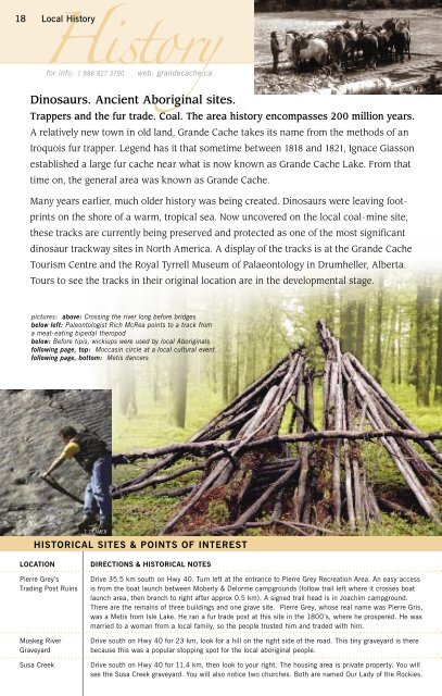
18 Local HistoryHistoryfor info: 1 888 827 3790web: grandecache.caV. MOBERLEYDinosaurs. Ancient Aboriginal sites.Trappers and the fur trade. Coal. The area history encompasses 200 million years.A relatively new town in old land, <strong>Grande</strong> <strong>Cache</strong> takes its name from the methods of anIroquois fur trapper. Legend has it that sometime between 1818 and 1821, Ignace Giassonestablished a large fur cache near what is now known as <strong>Grande</strong> <strong>Cache</strong> Lake. From thattime on, the general area was known as <strong>Grande</strong> <strong>Cache</strong>.Many years earlier, much older history was being created. Dinosaurs were leaving footprintson the shore of a warm, tropical sea. Now uncovered on the local coal-mine site,these tracks are currently being preserved and protected as one of the most significantdinosaur trackway sites in North America. A display of the tracks is at the <strong>Grande</strong> <strong>Cache</strong>Tourism Centre and the Royal Tyrrell Museum of Palaeontology in Drumheller, Alberta.Tours to see the tracks in their original location are in the developmental stage.pictures: above: Crossing the river long before bridgesbelow left: Paleontologist Rich McRea points to a track froma meat-eating bipedal theropodbelow: Before tipis, wickiups were used by local Aboriginalsfollowing page, top: Moccasin circle at a local cultural eventfollowing page, bottom: Metis dancersT. DEAMERHISTORICAL SITES & POINTS OF INTERESTLOCATIONPierre Grey’sTrading Post RuinsMuskeg RiverGraveyardSusa CreekDIRECTIONS & HISTORICAL NOTESDrive 35.5 km south on Hwy 40. Turn left at the entrance to Pierre Grey Recreation Area. An easy accessis from the boat launch between Moberly & Delorme campgrounds (follow trail left where it crosses boatlaunch area, then branch to right after approx 0.5 km). A signed trail head is in Joachim campground.There are the remains of three buildings and one grave site. Pierre Grey, whose real name was Pierre Gris,was a Metis from Isle Lake. He ran a fur trade post at this site in the 1800’s, where he prospered. He wasmarried to a woman from a local family, so the people trusted him and traded with him.Drive south on Hwy 40 for 23 km, look for a hill on the right side of the road. This tiny graveyard is therebecause this was a popular stopping spot for the local aboriginal people.Drive south on Hwy 40 for 11.4 km, then look to your right. The housing area is private property. You willsee the Susa Creek graveyard. You will also notice two churches. Both are named Our Lady of the Rockies.