- Page 1 and 2: Hong Kong Geology Guide Book
- Page 3 and 4: Hong Kong Geology Guide Book Geotec
- Page 5 and 6: FOREWORD Despite having a relativel
- Page 7 and 8: Table of Contents Page Preface 1 Fo
- Page 9 and 10: 21. Power of Weathering - Erosion T
- Page 11: Plover Cove Reservoir, Northeast Ne
- Page 15 and 16: Conglomerate overlying horizontally
- Page 17 and 18: Bureau of Geology and Mineral Resou
- Page 19 and 20: How to Get There The Permian sedime
- Page 21 and 22: Guide to Field Observations Because
- Page 23 and 24: Comments Outcrops of Permian rocks
- Page 25 and 26: Kau San Tei, Tai O, Lantau Island I
- Page 27 and 28: ock make up 95% of the Formation. I
- Page 29 and 30: Sediments infilling a groove - tran
- Page 31 and 32: Lai Chi Chong, East New Territories
- Page 33 and 34: Footpath from Pak Sha O to Lai Chi
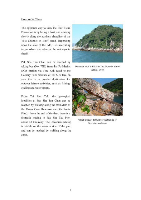
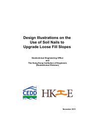
- Page 35 and 36: Guide to Field Observations The opt
- Page 37 and 38: Newsletter, v. 4, pp 1-4. Sewell, R
- Page 39 and 40: Outline of the Geology Exposures of
- Page 41 and 42: Formation Rock Type Depositional En
- Page 43 and 44: East Ping Chau, Eastern New Territo
- Page 45 and 46: The dolomitic siltstone, particular
- Page 47 and 48: Study of the rock outcrops, particu
- Page 49 and 50: Tai Shek Mo, Lo Wu, Northern Territ
- Page 51 and 52: contact with the Jurassic Tai Mo Sh
- Page 53 and 54: Comments In addition to extensive e
- Page 55 and 56: Tsing Shan Monastery, Tuen Mun, Wes
- Page 57 and 58: Ling Tao Monastery is best reached
- Page 59 and 60: and may have been formed by small-s
- Page 61 and 62: these outcrops stand out prominentl
- Page 63 and 64:
References Rock cores with marble c
- Page 65 and 66:
Ho Tin Tsuen Service Reservoir, Tue
- Page 67 and 68:
Brecciated andesite near Tuen Mun N
- Page 69 and 70:
contains very few brecciated clasts
- Page 71 and 72:
Shek Lung Kung, Tsuen Wan Chapter 1
- Page 73 and 74:
with some quartzite or chert debris
- Page 75 and 76:
Comments The Repulse Bay Formation,
- Page 77 and 78:
Tai Mo Shan, New Territories Introd
- Page 79 and 80:
and quartz, with minor biotite mica
- Page 81 and 82:
taken on rock outcrops, and not on
- Page 83 and 84:
Nei Lak Shan, Ngong Ping, Lantau Is
- Page 85 and 86:
which crop out on the lower part of
- Page 87 and 88:
are represented by faults, which su
- Page 89 and 90:
Silverstrand Bay / HKUST, Sai Kung,
- Page 91 and 92:
Welded tuff, eastern side of Silver
- Page 93 and 94:
Comments During the geological surv
- Page 95 and 96:
Cape Collinson Road, Siu Sai Wan, H
- Page 97 and 98:
Tuff-breccia (1) Tuff-breccia (2) T
- Page 99 and 100:
References Allen, P. M. & Stephens,
- Page 101 and 102:
Outline of the Geology Access to Lu
- Page 103 and 104:
Water Bay Formation, Kau Sai Chau V
- Page 105 and 106:
pp 1053-1066. Sewell, R.J., Campbel
- Page 107 and 108:
Outline of the Geology Access to th
- Page 109 and 110:
1) At the base of many of the rock
- Page 111 and 112:
plus 14 plates & 3 maps. Fisher, R.
- Page 113 and 114:
lapilli crystal tuff of the Jurassi
- Page 115 and 116:
Mafic dyke with xenoliths of quartz
- Page 117 and 118:
Evolution of a headland, and the fo
- Page 119 and 120:
Sham Shui Kok, Lantau Introduction
- Page 121 and 122:
Geological map of Sham Shui Kok (fr
- Page 123 and 124:
within the feldsparphyric rhyolite,
- Page 125 and 126:
Sketch of Phase II dykes at Penny
- Page 127 and 128:
Li, X.C., Sewell, R.J. & Fletcher,
- Page 129 and 130:
How to Get There Buses from Tung Ch
- Page 131 and 132:
Joint pattern in Tong Fuk Quartz Mo
- Page 133 and 134:
and the Lion Rock Suite. A total of
- Page 135 and 136:
How to Get There The type locality
- Page 137 and 138:
Pegmatite vein formed in the pluton
- Page 139 and 140:
References Allen, P. M. & Stephens,
- Page 141 and 142:
in the properties and appearance of
- Page 143 and 144:
emains of weathering profiles becom
- Page 145 and 146:
piping, rilling and gullying. Hong
- Page 147 and 148:
pace for about half an hour. Pyrami
- Page 149 and 150:
Stacked stones covering a valley Er
- Page 151 and 152:
“Broken tortoise head” should b
- Page 153 and 154:
Lam Tsuen Valley, Tai Po, New Terri
- Page 155 and 156:
Outline of the Geology The Lam Tsue
- Page 157 and 158:
(Looking southwestward toward Lam T
- Page 159 and 160:
References Addison, R. 1986. Geolog
- Page 161 and 162:
Sha Tin, Ma On Shan, East New Terri
- Page 163 and 164:
silicon and aluminium selectively t
- Page 165 and 166:
open mining platform, which is loca
- Page 167 and 168:
Appendix I Outline History and Geol
- Page 169 and 170:
500 m in a NE-SW orientation at an
- Page 171 and 172:
haulage drive at the 110 m level. T
- Page 173 and 174:
Current condition of Ma On Shan min
- Page 175 and 176:
Mineral Origin and Occurrence Hardn
- Page 177:
Mineral Origin and Occurrence Hardn