Original - The MAN & Other Families
Original - The MAN & Other Families
Original - The MAN & Other Families
- No tags were found...

Create successful ePaper yourself
Turn your PDF publications into a flip-book with our unique Google optimized e-Paper software.
Special edition 'with additional plates limitedto 230 copies.
Nun's Cross.
THEUndent Stone Crosses ofDartmoorand itsBorderlandWILLIAMBYCROSSINGAUTHOR OF4"Amid Devonians Alps,"" Tales of the Dartmoor Pixies,'"A Hundred Years on Dartmoor," etc.REVISEDEDITIONIllustrated by T. A. Falcon, M,A.In many a green and solemn place,Girt with the wild hills round,<strong>The</strong> shadow of the Holy Cross,Yet sleepeth on the ground.RICHARD JOHN KING,<strong>The</strong> Forest of tlte Dartmoors.JAMES G.Exeter1902COMMIN
3 1963\\IorjH*^H 7 11605
viContents.CHAPTER VI.THK CROSSES OF MEAVY : <strong>The</strong> Meavy Oak A Missing Village CrossIts Discovery and Restoration Meavy Church Cross in Wallof Transept Tomb of Lady Seccombe Tomb of Walterof St. Matthew Greenwell DownMattacott Gratton ChapelGreenwell Girt Base of a Wayside Cross Urgles WigfordDown An Old Path. ... ... ... ... ...52CHAPTER VII.CROSSES ox THE LANDS OF AMICIA, COUNTESS OF DEVON :BickleighVale Maynstone Cross Woolwell Cross Bickleigh Cross<strong>The</strong> Church Socket Stone Copris Cross Buckland AbbeyBuckland Monachorum Cross Shaft of Cross on CrapstoneFarm Horrabridge Smalacumbe Cross Sheepstor Cross AMoorland Church An Ancient Church House <strong>The</strong> Pixies'Cave <strong>The</strong> Path of the Monks ... ... ... ...57CHAPTER VIII.MEAVY TO SAMPFORD SPINEY : Yennadon Socket Stone at DouslandWalkampton Church An Old Church House Socket-stoneHuckworthy Bridge Cross on Huck worthy CommonSampford Spiney Cross Whitchurch Down ... ... 67CHAPTER IX.THE ABBOTS' WAY : An Ancient Track Brock Hill Mire Red LakeFord Broad Rock Plym Steps Springs of the PlymSiward's Cross Its Early Mention Inscription on the CrossBond mark of the Monks' Moor Course of the Abbots' Way<strong>The</strong> Windypost Moortown Cross on Whitchurch DownMonkeys' Castle A Broken Wayside Cross Some TavistockWorthies ... ... ... ... ... ... 71CHAPTER XA GREEN PATH OF THE MOOR : Buckland to the South-east BorderCrazy Well Pool Piers Gaveston A Broken Cross Remainsof Cross by the Wayside Stone Pillar Fox Tor Tomb ofChilde the Hunter A Tradition of the Forest A DespoiledMonument Discovery ,of a Kistvaen Death of the Lord ofPlymstock Fox Tor Newtake and its Crosses Crosses of TerHill Stannaburrows <strong>The</strong> Down Ridge Crosses Horse FordHorn's Cross An Old Road Queen Victoria's Cross atHexworthy Holne Moor Cross in Holne Churchyard Birthplaceof Charles Kingsley Cross at Hawson Buckfast AbbeyBase at Ashburton Cross at Gulwell ... ... ...84CHAPTER XLFROM THE TAVY TO THE TAW : Tavistock Old Market CrossHermitage of St. John Inscribed Stones A Period of ReligiousActivity Tavistock Abbey Remains of Cross at Peter Tavy
Contents.viiSteven's Grave Longtimber Tor Mary Tavy Clam MaryTavy Cross Forstal Cross Brent Tor Lydford Bra TorBase at Sourton Cross on Sourton Down An AncientInscription Cross formerly at Okehampton North Lew CrossOkehampton Park Cross at Fitz's Well Pixy-led TravellersInscribed Stones at Belstone and Sticklepath ... ... 108CHAPTER XII.AT THE FOOT OF COSDON : Zeal Head Cross Cross at South ZealStory of John Stanbury Moon's Cross South TawtonOxenham Cross Tradition of the White Bird Cross at RingholeCopse Cross at Addiscott Firestone Ley Cross at WestWeek An Ancient Border Farmhouse ... ... ... 126CHAPTER XIII.THROWLEIQH TO MORETONHAMPSTEAD :Fragments of Crosses atThrowleigh An Ancient Base Restoration of the CrossGidleigh Murchington Gidleigh Park and Leigh BridgeCross at Holy Street Base of Cross at Chagford Cross atWay Barton Surroundings of Chagford Cross near CranbrookStone Cross Week Down Shorter Cross ... ...132CHAPTER XIV.FROM MORETONHAMPSTEAD TO THE WESTERN BORDER COMMONS :An Old Road Cross at Lynscott Headless Cross AncientGuiding Stones Beetor Cross A Traditionary Battle Bennet'sCross Heath Stone Newhouse Story of the Grey WethersMeripit Hill Maggie Cross Jonas Coaker Cut Lane <strong>The</strong>Lich Path Clapper Bridges <strong>The</strong> Rundle Stone Long AshHill ... ... ... ... ... ... ...140CHAPTER XV.CROSSES ON THE BOVEY RIVER : Horse Pit Cross An Old-timeVillage North Bovey Cross Cross at Hele Tradition of aChapel by the Stream Disappearance of the Manaton CrossIts Socket-stone Cross at South Harton Gate Cross Park<strong>The</strong> Bishop's Stone Inscribed Stone at Lustleigh Crosses iatBovey Tracey Cross at Sanduck ... ... ... ...152CHAPTER XVI.WIDECOMBE-IN-THE-MOOR AND THE CROSSES IN ITS NEIGHBOUR-HOOD :Ilsington Bag Tor Mill Cross on Rippon Tor Crossin Buckland Churchyard Wayside Cross at Buckland DunstoneCross in Vicarage Garden at Widecombe Base of Crosson Widecombe Green Cross in the Churchyard ThunderStorm of 1638 Hameldon and its Barrows Hameldon Cross<strong>The</strong> Coffin Stone Dartmeet Ouldsbroom Cross CrossFurzes Dean Prior Ancient Track to Plympton Conclusion. 161
PREFACE.IN mycountry,former notices of the Stone Crosses of the Dartmoorthose existing- on the moor, and those to be foundin the cultivated portions of the border parishes,with in separate books. In the following pageswere dealtthese twoare combined, and much new matter, rendered necessary bythe altered state of some of the objects described, has beenadded. This has required some re-casting, and renders thepresent in great measure a new book.Some of the remarks prefixed to my earlier description ofthe Old Crosses of the Moorlands I venture to repeat here.I stated that my explorationson Dartmoor had extendedover many years, and had enabled me to gather much ofinterest pertaining to its history, its customs, and its objects ofantiquity. My researches in that regionof tor and streamI have never tired of pursuing, a love for its dear old hills,extending back as far as memory will carry me, attractingme to its wild solitudes, where, by the side of the stonecircle and the moss-covered cairn, we seem to stand on theborderland between the present and the distant past.How much of poetryis there in the memorials of apeople who lived on these hills, and who saw the moor aswe see it now ages ago. <strong>The</strong>re is truly a rich reward offeredto the student of our antiquities, which is denied to thosewho look with indifference upon the remains of a bygoneday. <strong>The</strong> light shed by the grey stones of the Celt, enablesus to read something of the past, and as we advance to
xPreface.historic times, and find the menhir no longer reared upon theheath, and that the circle and the dolmen cease to be upraised,the symbolof that faith which is the salvation offallen man, rough-hewn from the moorstone block, takestheir place, and the lamp is kept brightly burning.But these memorials which testify to the presence of menwho set up by the green paths of the moor the emblem oftheir religion, have, in many instances yielded to the rudebuffetings of the wintry blast, or have been cast down bythose in whom, in a later day, these rudely fashioned stonescould call up no tender feelings. Too often have I discoveredan old cross overturned and partially hidden fromview by the heather,its broken shaft and mutilated armssilently upraiding the carelessness that permitted itto remainprostrate on the ground.To chronicle the existence of such as were previouslyunknown and to collect evidence, if such might be discovered,respecting the time and purpose of their erection,as well as of those of which mention had been made byothers, has been to me a very pleasant and congenial task ;and the happy days spent on the breezy hills of Dartmoorin my search for these relics, which the companionship Ienjoyed rendered happier still, will never be forgotten.<strong>The</strong>se remarks were written some fifteen years ago, andDartmoor is now to me as ever it was. But previous totheir appearance had made I an appeal in behalf of thestone crosses of that old-time region, and it has been asource of gratification to me to find that what little I havedone has not been without its effect. Since I first drewattention to these memorials about fifteen of them havebeen re-erected, and once more are seen by the wayside andin the villages as they were of old. Such evidence respectingthe particular purposes they were designed to serve as Icould bring together, my knowledge of the topography of thedistrict enabled me the more clearly to read, and to draw the
Preface.xiconclusions set forth in these pages, and which in the opinionof a reviewer in Notes and Queries are not incorrect.One of my objects that of rescuing the wayside andvillage cross from neglecthas to some extent been accomplished.Another has been the furnishing of a correctdescription of them, that those who take an interest in thesememorials may learn something of their appearanceand surroundings, and so far as is possible, of their history ;and in this, too,I venture to hope I have not been entirelyunsuccessful. While we venerate the cross as a symbol ofthe Christian religion, it is less that this is so than that it isan object of antiquity that I have called attention to it, andpleaded for its Ipreservation. should desire that the samecare I have asked for the cross should also be bestowed uponthe stone remains we usually connect with paganism.I desire to express my indebtedness to Mr. T. A. Falconfor the pains he has taken in obtaining so fine a series ofphotographs for the express purpose of illustrating thisvolume, and for the use of a few which appeared in his bookDartmoor Illustrated.WM. CROSSING.Black Down, Dartmoor,June, 1902.
Wa Cruets liHa IDera.<strong>The</strong> dark'ning shadows filledthe vale,<strong>The</strong> way seemed long and drear,Rough was the track and hard to trace,And none to guide was near ;And soon my falt'ring steps were stayed,Two paths before me lay,Oh, for a friendly hand to aidAnd show to me the way !When lo,a rudely fashioned stoneFrom out the gloom appeared,A moss-grown cross, in days long flownBy pious hands upreared.It showed a straight and narrow pathNo more my steps would strayAnd doubts had ceased to trouble nowThat I had found the way.'Twas thus when in the wilderness,I tried to pierce the gloom,And find a path to that bright landThat liesbeyond the tomb,<strong>The</strong> Promise of the Book shone forth,And by its cheering rayRevealed the Cross of Calvary,And then I knew the way.
THEANCIENT STONE CROSSESOFDARTMOOR & ITS BORDERLAND,CHAPTER I.An Old World Region and One of its Antiquities*Extent of Dartmoor <strong>The</strong> Border Towns Wildness of the Moor<strong>The</strong> Forest Perambulations A home of Ancient Customs BorderScenery 'Antiquities <strong>The</strong> Cross an Object of Veneration Purposesof the Stone Cross Dartmoor Crosses Rude in Appearance <strong>The</strong>irSurroundings <strong>The</strong> Border Crosses.<strong>The</strong> wild and elevated tract of country known as Dartmooris situated in South Devon, and, according to a reportby Dr. Berger, in Moore's history of the county, containsnearly three hundred and fifty square miles of surface.<strong>Other</strong> authorities, however, estimate it to be considerablyless in extent, the difference arising accordingly as the severalcommons lying near what is now considered as Dartmoorproper, have been included or not. <strong>The</strong>se commons partakeof its character to a very great degree, and undoubtedly atno distant time formed a part of it. <strong>The</strong>re is a large extentof moorland lying to the eastward of Moretonhampstead andLustleigh, bounded by the river Teign, which De la Beche, inhis Report on the Geology of Cornwall, Devon, and West Somerset,considers to be both geologically and geographically a partof Dartmoor, and it was by including this and other similartracts, that Dr. Berger arrived at the estimate he has given ofits size. <strong>The</strong>se portions of moorland have, however, been cutoff by cultivation from the moor proper, and have not beenincluded by the other authorities when making their estimates.B
2 <strong>The</strong> Ancient Stone CrossesIn the report of a Committee of the House of Commons,made in the early years of the nineteenth century, the size ofthe moor is given as one hundred and thirty thousand acres,or two hundred and three square miles, and this we may considerto be the extent of what is now generally known asDartmoor.<strong>The</strong> market towns and principal villages on its bordersare Okehampton, Chagford, Moretonhampstead, Ashburton,Holne, South Brent, Ivybridge, Cornwood, Plympton,Shaugh, Meavy, Walkhampton, Tavistock, Lydford andBridestowe. Its most southerly point is at the foot of theWestern Beacon above Ivybridge, and the distance from thisspot to its northern verge, immediately above the market townof Okehampton, is, as the crow flies, about twenty-threemiles. Its average breadth is about ten or twelve miles,though at its widest part, from Black Down on the west toIlsington Common on the east, it is over seventeen.<strong>The</strong> elevation of Dartmoor is between one thousandthree hundred and one thousand four hundred feet, whilemany of its hills attain an altitude of one thousand sevenhundred or one thousand eight hnndred feet, and some overtwo thousand, the highest being on its borders.Many of the hills are crowned with a rugged pile ofgranite rocks, known as a tor, which frequently assume grandand fantastic proportions. Numerous rivers take their rise inthe bogs which are found in many of its more elevated parts,among which are the Dart (which gives name to thedistrict), Teign, Taw, Ockment, Tavy, Walkham, Plym,Yealm, Erme, and the Avon, each having a number oftributaries. Its principal river, the Dart, is sometimeserroneously stated to have been so called from the swiftnessof its current, which, however, is not more rapid thanthat of other streams on the moor. In all probability thethe name is derived from the Celtic word dwr water a rootfound in the names of several rivers in countries peopled byCeltic tribes.In some of the more desolate parts of Devon's lonely regionthe eye rests upon nothing but a vast stretch of heath, withhere and there a tor, peeping over the gloomy looking ridges, adesert waste, from which even the faintest signs of civilizationare absent. In other parts are deep valleys down which rush
Of Dartmoor and its Borderland. 3foaming torrents over rocky beds, the precipitous sides beingclothed with furze and heather, with many a huge graniteboulder half hidden in the wild and tangled growth, thenumerous tors lifting high their rugged crests and standinglike giant sentinels around.King John disafforested the whole of the County of Devon,with the exception of Dartmoor and Exmoor, and though theformer when it was afterwards bestowed upon Richard, Earlceased to be a forestof Cornwall, by his brother, Henry III.,in law, since none but a king can hold such unless by specialwarrant, it has nevertheless continued to be regarded as aforest down to our own day, and is generallyso called.It is part of the Duchy of Cornwall, and isconsequentlyalways held by the male heir apparent to the throne, as duke,but in the event of their being none such, it reverts to theCrown for the time being. Perambulations have been madefrom time to time for the purpose of denning the limits of theforest, which lies in the centre of the moorland region, itsboundaries being, in some parts, several miles from thecultivated country. <strong>The</strong> intervening tract, which presentssimilar characteristics to the forest, was formerly known asthe Commons of Devonshire. It is made up of parts of anumber of parishes surrounding the forest, many of whichof pasturage andpossess Venville rights, as certain privilegesturbary are termed. <strong>The</strong> forest itself lies entirelywithin theparish of Lydford.<strong>The</strong> return of a perambulation made in the year 1240when Richard, Earl of Cornwall, was the lord of Dartmoor,sets forth the bounds of the forest, and of this there areseveral copies extant. A survey of the forest was alsomade in 1609, and the bounds as named in this, approachvery closely to those generally recognised at the presenttime. <strong>The</strong>se are defined by natural objects, such as a hill,a tor, or a river. <strong>The</strong> forest is divided into quarters, ofwhich the north is the largest.Ancient customs still survive on Dartmoor, thoughgradually giving place to modern usages. Yet it is stilla home for many of our old superstitions and legendary tales,a place where much that found favour with our ancestors,and which, perhaps with questionable taste, is now voted outof fashion, still finds a refuge, and where freedom from all
4 <strong>The</strong> Ancient Stone Crossesartificiality may be enjoyed. <strong>The</strong> artist may there findample employment for his pencil, the disciple of Walton mayrevel to the full in the pursuit of his art. <strong>The</strong> geologist,the botanist, or the antiquary have there a rich field in whichto indulge their various tastes, and the lover of nature cannever tire of the delights afforded by a ramble through thesecluded valleys, and over the breezy hills of wild andrugged Dartmoor.But while the interior of the moor bears the palm forgrandeur and itsublimity, is on its borders that one mustlook for the fairer and more beautiful scenes, where nature'ssofter features are exhibited in striking contrast to the sterneraspect of the moor.Here are deep combes, having their sides partially cultivated,or clothed with thick coppices of oak, running far upinto the wilds, in many of them more than one substantiallybuilt farmhouse of ancient date nestling in some shelterednook, often in close proximity to a rugged tor ;narrow gorges,through which the rivers leave their mountain birth-place,affording a glimpse of the barrenness beyond steep hillsides;rising from enclosures formed by roughly constructed granitewalls, man's handiwork being of a ruder and more primitivestyle as the confines of the moor are approached roads wind-;ing by the base of these frontier heights, often carried over thestreams that rush impetuously down the valleys, by grey stonebridges, forming picturesque objects, which the artist delightsto pourtray ; quiet villages and hamlets on the very verge ofthe waste, the low towers of the little churches formed ofgranite from the rocky piles that rise so near to them ;andsomewhat further removed, the small market towns we havenamed, now brought more into communication with thelarger centres of population, but which for centuries sleptquietly in the shadow of the ancient hills.No district in our country can boast of so great a numberof rude stone remains as Dartmoor, every part of itfurnishingexamples of most of the pre-historic monuments known to theantiquary. And it is also rich in relics of mediaeval times, andamong these the stone cross is certainly not the least interesting.But of all the objects of antiquity few have, perhaps,come down to us in so mutilated a condition as this the onewe should expect would have had bestowed uponit the
Of Dartmoor and its Borderland. 5greatest care. Not only did the wayside and village crosssuffer at a time when men's mistaken zeal caused them tocommit acts of destruction in and around our churches, but inquite recent years they have received, in too many instances,but little consideration. In the one case the guiding influencewas bigotry in;the other, ignorance or apathy. <strong>The</strong> latter,it is pleasing to know, are being removed ;the former we canpity, without being so uncharitable as to blame. <strong>The</strong>re is, intruth, no room for blame. <strong>The</strong> men who cast out the gravenimages from the churches, and overturned and shattered thesculptured stones by the wayside and on the village green,warred not against the cross, but against idolatry.Apart from the interest attaching to the cross as a symbolof Christianity, it has other claims on our attention. Noobject in our island belonging to historic times is older. Itexisted before the earliest churches, for without doubt thelatter came to the cross the cross did not come to them.Where it was reared, people gathered for worship, and believershad before their eyes that which would cause them toremember the great work accomplished for mankind, as indays remote the stones set up in the sacred river remindedthe Israelites of their deliverance from bondage. <strong>The</strong>re is atradition connected with the church and cross at North Lew,a parish to the north of Dartmoor, which tells us that thelatter was anciently a preaching station of the monks ofTavistock. After a time a church was commenced to bebuilt. First one aisle, then a second and a third, and so thestructure was gradually completed.But the cross, though no longer needed for its originalpurpose when each parish had its church, remained still anobject of veneration, while within the sacred building itsplace was supplied by the great rood. And as it had beenduring long years the one point to which the littlecommunitywere drawn for worship, so it came to be looked upon as thecommon centre of the village, and from ittidings were proclaimedin which the people were interested, and much tookaround it that affected the common weal.placeAn object that could turn the thoughts to an event of suchimportance as the great sacrifice once offered for mankind, waspeculiarly fitted for setting up in such places as the wayfarermight pass, for it became a guide to him in a double sense.
6 <strong>The</strong> Ancient Stone CrossesAnd thus by the track that led from town to town, and by thelonely paths over the bleak and barren hills,was the crosserected, that he who journeyed might feel certain of his way.Where a road diverged from, or was crossed by another, itwas frequently placed* As the old tracks on Dartmoor werein many cases nothing more than a grassy path, and in placesscarcely to be distinguished, such marks were of the greatestutility, and no doubt often safely guided the traveller whenpursuing his way over the hills of the silent moor.As a bond-mark, too, was the cross particularly suitable.<strong>The</strong> importance in early times of such being respected wasvery great, and an object reverenced as was the cross wouldbecome an efficient guard against encroachments. Many ofthe possessions of religious houses had their boundaries sodefined, as is evidenced by records wherein these are named,not always by crosses set up for the purpose perhaps, but byadapting those already existing. That some of the crosses inthe Dartmoor country also marked the limits of a sanctuary isnot improbable.<strong>The</strong> cross was also erected at the place of burial. In veryremote times we know it was the custom to raise a stonepillar as a monument over the dead, and in the early days ofChristianity the cross took its place. <strong>The</strong> ancient observancewas not given up, the form of the monument was simplychanged, and the old menhir and the inscribed stone gaveway to the symbol of the new faith. It is indeed most likelythat the very earliest crosses were those connected with therites of sepulture. <strong>The</strong> sacred emblem was at first merelyinscribed upon the rude pillar, until at length men began togive the latter the shape of the former, and so the cross wasgradually substituted for the upright stone.<strong>The</strong> crosses which are to be found on Dartmoor, like mostof the Devonshire examples, are of simple form, and cannotboast of the beauty which belongs to some of those existingto the westward of the Tamar. A few only possess any"<strong>The</strong>y are often seen in such situations, and the former existence ofothers is revealed by the names of many places upon our highways and inour lanes. It is not, however, suggested that this is always the case whenthe word " Cross " is affixed to a name sometimes it means; nothing morethan a cross-road.
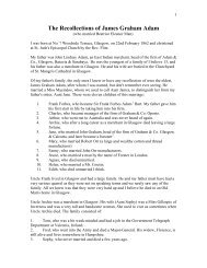
<strong>The</strong> Drizzlecombe Menhir.
Of Dartmoor and its Borderland. 7ornamentation, and that in a very slight degree; and, with oneor two exceptions, no inscriptions are to be seen on them.<strong>The</strong>ir surroundings, however, invest them with a charmpeculiarly their own ;for we cannot behold these old lichenstainedand weather-beaten memorials of the past, standing inclose proximity to the remains of the rude habitations of theCelts, without contrasting in our minds the dark times whenthose huts were peopled, with the clear daylight which beamedforth when the cross was planted, and with the blessingswhich Christianity has spread over the land.Among the grey tors theystand in solitude the farstretchingheath on every side with no sound to break thestillness that reigns around but that of the rushing of thestreams from the rugged hill-sides. As we gaze upon them,we can let our thoughts stray back to the time when they werefirst reared, and in fancy may see the wondrous events whichhave since taken place on the stage of this world's vast theatre.Nor will it fail to strike us how little have all these eventsaffected what we can see around us. <strong>The</strong> granite tors still lifttheir lofty heads to the sky, the heather and gorsestillbloom on the moor, the stream yet pursues itsway over itsrocky bed, and all is here unchanged. While events whichhave shaken the outside world, and have decided the fate ofnations, have been occurring, these hills and valleys, hugerocks and winding streams, have remained as in the days ofold, and these venerable stone crosses have been lost in thesolitariness of the moorlands.At early morn when all is fresh and bright, when the dewdropssparkle on the heather," And drowned in yonder living blue,<strong>The</strong> lark becomes a sightless song,"the impressionable mind will experience a pleasurable emotionat beholding here, far from the haunts of man, the emblem ofthe Christian faith. At the hour of sunset, when the shades ofevening are beginning to settle over the wilds, and we hearthat moaning sound so peculiar to the Dartmoor rivers as thetwilight approaches, a calm feeling steals over us, which isheightened when, perchance, we findourselves beside an oldgranite cross, alone on the heath ;and when night spreads herdark robe over mountain and plain, and the sole light is that
8 <strong>The</strong> Ancient Stone Crosseswhich is lent by the pale stars, that form will forcibly remindus of the power which the religion of the cross has exercisedover the darkness of our land, and which it has so happilydispelled.<strong>The</strong> hands that fashioned these time-worn relicshave longsince mouldered in the tomb ;and they themselves are ofttimesoverturned and shattered, deeply impressing us as wecontemplate their ruin, with the certainty that all the works ofman will fall and crumble away before the touch of Time.And in many of the rural settlements around the greatuplands, and on the roads that lead to them, we shall alsomeet with the objects which it is now our purpose to examine.Some of these will, of course, differ in character from thosethat exist upon the moor itself for here the market-cross and;the churchyard-cross will claim a share of our attention, whileon the waste they were set up either to mark a boundary, or asguides to the wayfarer. And the difference is not only in theircharacter, for although the crosses of the moorland bordersdisplay little elaboration in their fashioning, yet there arefew of quite so rude a type as the examples seen on themoor itself. We shall not be disappointed, however, in ourexamination of them, though we do find them lack ornamentation,for there is much in them and their associationsto interest and attract, while the scenery amid which weshall roam as we visit in turn these venerable memorials,will not fail to call forth our admiration, and constitute anadditional delight.In our ramble we shall seldom stray far from the old moor,and it will not need that we look towards its hills to tell us of itsproximity, for nearly every step we take will remind us of this.<strong>The</strong> old-fashioned farm-house with its wide porch and parviseroom, and mullioned windows, and the lowly thatched cottage,alike of granite and;boulders partly covered with moss, andhalf-hidden by ferns, by the sides of many of the narrowlanes, will all plainly reveal that we are near the land of tors,and will cause us to realise when we sometimes wander byenclosed fields, and by the dwellings of men, that we are yetin the Dartmoor country.
inOf Dartmoor and its Borderland. 9CHAPTERII.<strong>The</strong> Boundary Crosses of Brent Moor.Brent Hill Brent Fair Church of St. Patrick Christopher JellingerBrent Market Cross Hobajon's Cross Old Map of DartmoorButterdon Stone Row Three Barrows Western WhitaburrowPetre's Cross Sir William Petre Buckland Ford <strong>The</strong> Abbots'Way Clapper Bridge Huntingdon Cross <strong>The</strong> Valley of the Avon.On the left bank of the Avon, a stream that has its sourcein a solitary part of the south quarter of the forest, asthe central portion of the great moor is termed, is situatedthe small market town of South Brent, and it is here that weshall commence our ramble. It is distant some mile and ahalf from the confines of the moor, to which several roadslead. Immediately to the north of it rises a lofty eminenceknown as Brent Hill, and on the west it is overlooked by theEastern Beacon on Ugborough Moor.<strong>The</strong> chief attraction in the immediate vicinity of the townis the first-named height, whence is commanded a mostextensive view, the beauty of which amply compensates thevisitor for the toil of the ascent. <strong>The</strong> greater part of theSouth Hams of Devon lies, as it were, at the feet of thebeholder, while . the other direction is a grand sweep ofmoor, with the ridge of Hameldon rising huge and boldagainst the northern sky.On the summit of Brent Hill are the scanty ruins of asmall building, locally reported to have been a chapel. It isalso stated to be the remains of a windmill, erected towards theend of the eighteenth century by Dr. Tripe, of Ashburton.What truth there is in this I know not, but if any,it wouldseem more probable that he converted some ancient buildingto his purpose. Many years agoI learnt from one whoremembered when much more of the ruin than now exists wasstanding, that the walls were pierced with loop holes, and hehad always heard that it was used as a " look-out house."
io <strong>The</strong> Ancient Stone CrossesWhether this was so, and it had ever served the purpose of aplace of shelter to the watchers of the beacon fire, I am unableto offer an opinion, but that such blazed upon this prominentheight, there seems little reason to doubt.*Less than half a mile to the northward of Brent Hill, andby the side of the road that leads from Lutton Green toGigley Bridge, is a small marshy spot known as Bloody Pool,though it is only in very wet seasons that much water can beseen there. What were supposed to be weapons of bronze,but which are in reality the heads of ancient fishing spears,were found there many years since, and may be seen in theAlbert Memorial Museum at Exeter.<strong>The</strong> manor and church of Brent belonged from a veryearly period to the Abbey of Buckfast ;after the Dissolution,the former was bestowed upon Sir William Petre, and in 1806a great portion of it was sold. <strong>The</strong>re are two fairs yearly,and Risdon tells us this was so in his time, but more ancientlyit seems to have been held once a year only, at Michaelmas,and lasted for three days. According to Risdon, one fair wason May-day, and the other on St. Michael's-day, but in1778, more than a century and a half after our topographerwrote his Survey of Devon, the days on which they stillcontinue to be held were fixed. <strong>The</strong> fairs commence atnoon on the Monday before the last Tuesday in the months ofApril and September, and continue till the Wednesday night ;but the Tuesday is now the day of the actual fair. <strong>The</strong> oldcustom of holding it "under the glove" is not departed from,the glove being raised upon a pole when the fair commences,and kept there during its continuance. This still prevails inmany towns and villages, and is an ancient form of charter a;glove sent to the inhabitants was a token that the rightsprayed for were granted.* If a signalling station so near to the Eastern Beacon on UgboroughMoor should seem to have been unnecessary, it may be well to explainthat it is doubtful whether that ever was a beacon hill. <strong>The</strong> nameappears to be a corruption of Pigedon, by which appellation itwas anciently known, according to an old map of Dartmoor, nowin the Albert Memorial Museum at Exeter. On the same map, the moor-is marked as Pickegate at the foot of the hill (now called Peek Gate)Yeat, and old people in the neighbourhood used to speak of the height asPicken Hill. Brent Hill would also seem to be the more suitable of thetwo for the purpose of signalling.
Of Dartmoor and its Borderland. 1 1<strong>The</strong> parish church dedicated to St. Patrick is situated atone end of the little town, on a knoll, at the foot of which flowsthe Avon. <strong>The</strong> tower is of earlier date than the church, andis of late Norman character, with some Early English additions.<strong>The</strong> occurrence of arches in the bottom stage, point toits having been the central tower of a Norman church, and thebuilding now used as a vestry appears to have formed one ofthe transepts of this early structure. Although in four stagesthe tower is not of great height.<strong>The</strong> font is of red sandstone, and is most beautifullycarved, being of the late conventional Norman type.In the fifteenth century a vicar of the parish was murderedin the church, and when it was restored about the year 1870under the direction of Mr. James Hine, of Plymouth, somehighly finished portions of a recumbent effigy and tomb werediscovered, which Mr. Hine conjectured to belong to the tombof this vicar. In 1436 Bishop Lacy reconciled the church,after its profanation by the murder.Christopher Jellinger, one of the ministers ejected from theChurch of England by the Act of Uniformity, in 1662, wassometime vicar of this parish. He was born near Worms,and studied at Basil and Leyden. After the Restoration theMarquis of Winchester offered to prefer him if he wouldconform, but true to his principles, he refused. He died atKingsbridge, at the ripe age of 83 years, continuing to preachwhen he was very old.<strong>The</strong> ringers of Brent observe some quaint customs at theirannual meeting and supper, duly electing for the year" a lordchief " and a " crier." <strong>The</strong>ir signatures are then entered inthe " ringers' book," which dates back to 1789.A few years ago Brent had its cross ;now ignorance hasdone its work, and it no longer exists. Within living recollectionit stood against the wall of the old market house, whichwas demolished many years ago. <strong>The</strong> cross was then removedto a court behind the Anchor Hotel, where it lay neglecteduntil a very few years since, when a builder broke itup andcarted it off to a building he was erecting in the parish ofDiptford. It is lamentable that such things should be. <strong>The</strong>cross was the only antiquity Brent possessed, and that hasbeen suffered to be destroyed. <strong>The</strong> shaft and arms wereoctagonal in shape, and the former tapered slightly. Its
12 <strong>The</strong> Ancient Stone Crossesheight was five and a half feet, and across the arms itmeasured two feet seven inches.But though there is no cross now in Brent itself, themoor belonging to the parish can furnish us with an example,and, for the purpose of examining this, and others on theboundary line of the forest, we shall leave the littletown, and direct our steps to Three Barrows, a lofty hillrising high above the left bank of the Erme. Our way willfirst take us by the foot of Splatton Hill to Lydia or LeedyBridge, a single arch spanning the Avon. Immediatelyabove it is a fine waterfall, while below a stately row ofbeeches throw their branches partly over the stream, alongthe bank of which is a path leading by the vicarage lawn tothe church. Passing up the hill, we reach the hamlet ofAish, at the higher end of which we turn into a lane on theleft, and, still ascending, at length enter upon the commonknown as Aish Ridge.From this elevated down Three Barrows can be plainlyseen, and for some considerable distance we shall have theadvantage of a moorland track which runs towards it. Thispath will bring us to Brent Moor at Coryndon Ball Gate,soon after which we shall commence the ascent of the hill,where, on the slope near the summit, we shall find theshattered remains of one of the objectsit is now our purposeto examine, lying amid the granite with which the ground isstrewed.Three Barrows, which is about three and a half milesfrom Brent and some two miles to the northward of HarfordChurch, is crowned with three large cairns, whence its name,and during an exploration of one of them by Mr. Spence Bate,recorded in the fifth volume (1872) of the Transactions of theDevonshire Association, part of a cross, consisting of one ofthe arms and the top of the shaft, was found near at hand.This he, with great probability, supposed to be a portion ofone which he states was set up by a jury of survey, empanelledto settle some bounds in this part of the moor about a centuryand a half before.He also considered that in it he saw all that remained of across which is mentioned on an old map of Dartmoor asHobajon's Cross, and which is there represented as standingon two steps, and is situated nearly in the middle of a row of
Of Dartmoor and its Borderland. 13upright stones. This row extends from Butterdon Hill, nearthe Western Beacon above Ivybridge, to within a shortdistance of Sharp Tor, which overlooks the enclosure knownas Piles Newtake. At the former placeit is seen leadingdirectly from a circle thirty-five feet in diameter, of which thestones, with the exception of two (and those partially so) arefallen. This encloses a small cairn about twenty feet indiameter, much dilapidated.It has been supposed that the old map in question datesback as far as 1240, in which year a perambulation of theforest was made, or even earlier; but, as Mr. J. BrookingRowe points out in his Cistercian Homes of Devon,'-' thiscannot be the case, because on it there is a representation ofthe Abbey Church of Buckland, which abbey was not foundeduntil 1278. He considers it to be of two centuries later date.Further on, I shall bring forward some evidence which Ithink will show that this view is the more correct one ;butwithout going into this question now, it certainly appears fromthe map that a cross was standing in the stone-row at the timeit was drawn, but I am not so sure that it was ever fixed onsteps as it is there represented. Another cross, which weshall notice hereafter, is shown on the map as standing onsteps in the same manner, although nothing of the sort is to beseen near it now, so that it is possible that this was nomore than a conventional mode of the draughtsman to indicatethe existence of these crosses, and it was not, perhaps, intended,or considered necessary, to convey a perfectly correctidea of their form.Mr. Bate accounts for the cross being erected in thestone-row on the hypothesis that those who reared it, findingthe dark clouds of superstition clinging to the heathen relic,were anxious to plant the symbol of Christianity amid therude erections of the Pagans. This, indeed, may have beenthe case, but I am inclined to think it quite as probable thatthe cross was set up simply as a boundary mark. When theobject for which the stone-row was primarily erected wasforgotten, it was naturally looked upon as a boundary, andstill continues to serve as such, constituting, as far as itand Harfordextends, the line which divides Ugborough* Trans. Devon Assoc., Vol. vii., p. 345.
14 <strong>The</strong> Ancient Stone CrossesMoors. As fresh perambulations of the bounds were made,in all likelihood new marks were added, and Hobajon's Crosswe may not unreasonably consider to be one of these.<strong>The</strong> mutilated cross which is at present to be seen, consists,as stated, of the top of the shaft and one of the armsonly. <strong>The</strong> arm is ten inches in length, the shaft measuringsixteen inches from its upper surface, and being about fourteeninches in width. As the sides of it, however, are notquite parallel, the width is not the same throughout, but israther greater at the top. It must have been a massive crosswhen in itscomplete state, with a breadth across the arms ofabout two feet eight inches ;its height, of course, it isimpossible to determine. <strong>The</strong> fracture runs across obliquelyfrom under the remaining arm. One side of the shaft is teninches in thickness, the other only seven inches. It is nowlying on the slope of the hill toward the river Erme, notfar from the north-western cairn.From the absence of any other cross near the spot, Ithink we may safely conclude that this is the one that thejury, of whom Mr. Bate speaks, erected on one of the cairnson this hill ;and that it is also the old Hobajon's Cross isnearly certain, for, although the existence of this mutilatedhead is not generally known, the name still lingers here asmall heap of stones at no greatdistance from the tophill being called by the moormen Hobajon's Cross.of theThis point forms the starting place when the bounds ofa portion of the moor in this locality, over which the lord ofthe manor of Ermington exercises certain rights, are perambulatedthe first record of such perambulation being inthe year 1603.If the supposition be correct, as no doubt it is, that we nowsee on Three Barrows a portion of this ancient cross, we knowthat it must have been brought from the stone-row, as wehave no reason to consider the map wrong in representing itas standing there, but other hands. I think, than those of thejury of survey did this. From the fact of the manor boundarymark bearing the name of Hobajon's Cross, it would seem likelythat at one time it was erected there, in which case we shouldperhaps be inclined to consider that those who were engagedin marking out those bounds, were concerned in the removalof the cross ;but I am of opinion that they were not those
Of Dartmoor and its Borderland. 15who took it from its original position, althoughit is notimpossible that they may have used it as a mark for theirboundary,In the account of Buckfast Abbey in Dr. Oliver's Monasticonthere is an inquisition on the boundary of Brent Moor, dated1557,* at which time certain rights and privileges pertainingto it were held by Sir William Petre in virtue of hispossession of the manor of South Brent. This boundary linewas marked by four crosses at certain points one on the;centre cairn at Three Barrows, one on the cairn known asWestern Whitaburrow, a third at Buckland Ford, and afourth at the confluence of the Avon, or Aune, with theWestern Wellabrook, and they each had the words " Bundade Brentmore," engraven on their faces. I am inclined tobelieve that it was for the purpose of serving as a mark tothese bounds that Hobajon's Cross was taken from the rowof stones, and if it ever stood on the little cairn marking theboundary of the lands over which the manorial rights ofErmington extend, it was taken there from Three Barrows, inwhich case the jury of survey, to whom Mr. Bate has alluded,must have found it there, and set itup once more upon thegreat cairn on the hill. <strong>The</strong>re is no trace of any inscription tobe seen on the portion which now remains of thisinterestingrelic, and how it became so mutilated it is impossible to say.I have carefully examined the stone-row on several occasions,but could never find any traces of the steps as shownon the map, and, as before observed, it is doubtful whetherthey ever existed.On a stone at the extreme end of a rowt nearest SharpTor, and which is much larger than most of the otherswhich compose it, is a small incised cross measuring seveninches in height and five and a half inches across. This stoneis evidently an addition to the row, but is distinguishable, at aglance, from a modern boundary post. It stands about threeand a half feet above the ground, and appears to mark someimportant point,as it is placed in the middle of a small, rough* Monasticon Dioecesis Exoniensis, p. 378.f From its commencement at the circle on Butterdon Hill, to its terminationat this stone, the row is one thousand seven hundred and ninety-oneyards in length. <strong>The</strong> distance of the centre cairn on Three Barrows fromthe stone is two thousand three hundred and twenty-five yards.
1 6 <strong>The</strong> Ancient Stone Crossescircular pavement, about six feet nine inches in diameter.May we not allow that there is a probability that this inscribedstone marks the spot where, in years long since flown, the oldcross was standing, and that it was set up, after the removalof the latter, as a memorial of itby those who wereinterested in preserving these particular bounds ? I do notforget that the map represents Hobajon's Cross as being in thecentre of the stone-row, and this stone as I have said, is at itsend ;but the row is continued from this point by modernboundary stones, and in all probability was so continued byolder bond-marks at the time the map was drawn, so that ifthe cross really stood on the spot in question, in placingit inthe middle of the row, the map would be substantially correct.<strong>The</strong>re is one consideration we must not overlook, which is,that it would not have been a very difficult task to removethe cross from Three Barrows, and to have re-erectedit in the row, instead of setting up another stone there in itsplace. But it is not unlikely that it was found to be broken,though perhaps not in such a mutilated state as we see itnow, and was no longer in a condition to be placed in its oldposition.<strong>The</strong> view from the commanding height of Three Barrows,or as old records have it, Threberis, is one of great varietyand beauty. A large portion of the country lying betweenthe southern frontier of Dartmoor and the Channel is spreadout before us, and most of the prominent headlands on theSouth Devonshire coast are plainly visible. On the otherside we look into the moor. Away to the northward isseen the boggy land in the neighbourhood of Erme Head,with the distant tors peeping over the dark brown ridges.Westward the river flows at a great distance below thewind-swept height on which we stand, and Piles Wood isdiscernible far down the steep, stretching along the bankof the stream.Before leaving Three Barrows we must not omit toobserve the fine reave, or boundary bank, which runs up fromthe East Glaze to the centre cairn, and pursuesits coursedown the slope of the hill towards a little stream that fallsinto the Erme.Proceeding in a northerly direction we shall make ourway to Western Whitaburrow, one of the bounds of the
Of Dartmoor and its Borderland. 17forest ;and in so doing shall follow the line of posts thatmark the boundary of Brent Moor, which boundary appearsto be indicated on the old map by a line on which are placedwhat seems to be meant for three stones.<strong>The</strong> cairn which bears the name of Western Whitaburrowis sixty-three yards in circumference, and according to theinquisition alluded to, the second cross marked with the words" Bunda de Brentmore " was placed here. Until about theyear 1847 it was to be seen erect on the centre of the cairn ;but it was then partially destroyed by some workmen in theemploy of a company which was formed for the purposeof extracting naphtha from the peat that here abounds,but the undertaking was not a success. <strong>The</strong> workswere close to Shipley Bridge, and the peat was takenthither from this spot on tram-waggons the old tram-road;is now in a very ruinous condition, but still serves as abridle-path.<strong>The</strong>re being no place of shelter near, the labourers erecteda house on the cairn with the stones of which it was composed,and, requiring a large stone as a support for the chimneybreast,they knocked off the arms of the cross and used theshaft for that purpose.I learnt this over thirty years agoon the works atfrom one of the men who had been employedthe time, and gleaned further facts concerning the cross fromothers, who had then long known the moor. It may herebe well to correct a statement that appeared in a guide-book,published about three years since, to the effect that thecross was discovered by the Ordnance surveyors at a"factory building near Didworthy." <strong>The</strong>re is no foundationwhatever for it. <strong>The</strong> house at the cairn has been takendown for many years ; the walls, to the height of about threeor four feet, being all that is now to be seen of it, but theshaft of the cross has, fortunately, not been lost. It is nowset up on the cairn, and has had the broad arrow cut on itbythe Ordnance surveyors. It measures four feet in height,and about fifteen inches in width. At the end which is nowuppermost there is a tenon, and I therefore take this to bethe bottom of the shaft, which was so fashioned in orderthat itmight fit into a socket. <strong>The</strong> name of it, too,unforgotten, for the spot is seldom called byis stillits olderc
1 8 <strong>The</strong> Ancient Stone Crossesappellaton of Whitaburrow,* but is generally known asPetre's Cross.Sir William Petre, of whom Prince in his Worthies ofDevon gives us an account, and who was, as already stated,the possessor of certain rights over Brent Moor was bornat Tor Newton, in the parish of Tor Brian. He wasSecretary of State in four reigns, those of Henry VIII.,Edward VI., Mary, and Elizabeth ; and, it is said of him thatin this office he was " smooth, reserved, resolved, and yetobliging." He amassed great wealth derived from themonastic possessions which were granted to him. He diedin 1571, and was buried at Ingatestone in Essex.Our search for the third cross will take us to BucklandFord so we shall make our way down the hill in a northeasterlydirection, and passing a bound-stone, shall soonreach the foot of a steep narrow gully, close to which weshall observe an old path, which we shall descend for a shortdistance to a point where it crosses a small stream which fallsinto the Avon just below. This is Buckland Ford, but weshall look in vain for the cross. This ford is shown on somemaps as being on the Avon. This is wrong ; it is the crossing-placeover a tributary of that river, as above described.It doubtless was so called in consequence of being on themonks' path leading to Buckland. I have carefully searchedaround the spot, yet have never been able to find it, nor can Ilearn that any one has ever seen Some it. mining operationsappear to have been carried on near the bank of the Avon,and it is possible that the cross may have been destroyed bythose who were concerned in them.<strong>The</strong> old track which crosses the stream at this ford iscalled the Abbots' Way, and can be traced from Dean Moorfor several miles, passing the source of the Ernie, and thehead waters of the Plym.It formed a direct means of com-*So spelt with the addition of an e in the survey of the forest of 1609 ;in the perambulation of 1240, the name is spelled Whyteburghe. It isEastern Whitaburrow, however which is mentioned in these perambulations,and not Western Whitaburrow. <strong>The</strong> cairn known as EasternWhitaburrow is ninety yards in circumference, and twelve yards inheight. Tne name is pronounced with the i long, as though spelled\Vhite-a-burrow,
Of Dartmoor and its Borderland. 19munication between the abbeys of Buckland and Tavistock onone side of the moor, and Buckfast on the other. <strong>The</strong> nameby which I have always heard it called by the moor-men isJobbler's or Jobber's Path, which it doubtless obtained frombeing used by the yarn -jobbers in former days. <strong>The</strong> monksof Buckfast were extensive traders in wool, and this commodityand yarn spun from it, no donbt often formed theloads which were carried on the backs of horses on this oldroad. It appears more than probable that itpassed nearwhere Princetown now stands, for I find that Mr. Burt in hispreface to Carrington's Dartmoor, published in 1826, statesthat traces of a trackway called Jobbers' Cross were visibleacross bogs near the prison.Although we shall be unsuccessful in finding the cross atBuckland Ford, we shall be well repaid for having visited thespot, for the surroundings combine to form a most pleasingpicture of a moorland valley, secluded and quiet, and closed inby hills on every hand. Behind us stretches the heatheryslope known as Bush Meads, anciently Bishop's Meads to;our left (insummer time covered thickly with ferns) a hillrises precipitously from the Avon, which here bends round ina fine sweep. On our right hand the bottom of the valley isshut in by Dean Moor, and immediately in front of us, on theopposite side of the river, is Huntingdon Warren, a find boldhill of good hard ground, free from heather, but coveredin places with scattered granite. Several enclosures, the rudeerection of the Danmonii, are in sight, and tell us that thisquiet valley was once thickly peopled by the ancient inhabitantsof the moor.Not far from where we stand the Avon is spanned by arude bridge of two openings, formed of slabs laid on a centrepier, consisting partly of the natural rock.^ Further up the*Bridges formed of huge flat stones laid upon rudely wrought abutmentsand piers, are termed clappers, and are almost peculiar to the Dartmoorcountry. This bridge, although constructed in a precisely similarmanner to those which are undoubtedly of some age. is distinguishablefrom them at a glance. Here the edges of the granite are not rounded asthey are in the older examples. <strong>The</strong> two stones which form the roadwayand which once were evidently one, show the marks of wedges used inspliting them. I have been told that it was built by the first owner of thewarren, which was formed ear!}' in the nineteenth century. <strong>The</strong> bridgehowever, presents a very picturesque appearance.
2o <strong>The</strong> Ancient Stone Crossesstream is a craggy hollow, though we can see little of it, fromwhich the river issues. It there falls in a series of smallcascades and widely spreading rivulets over a number ofrocky ledges, olaced at the head of the solitary glen.From Buckland Ford we shall follow the Abbots' Wayto the Avon, and tracing the river downward shall crossit at another ford, at a spot known to the moormen asLower Huntingdon Corner, immediately above the confluenceof the stream with the Western Wellabrook. Itis here the inquisition says, the fourth cross was setup, and we shall be gratified at observing it standingerect a few yards from the bank of the river. It is nowknown as Huntingdon Cross, and is situated at the corner ofthe warren. It isimmediately within the forest bounds, andclose to the spot where the parish of Lydford (inwhich thewhole of the forest lies) joins the parishes of Dean andBrent.Although the crosses at Buckland Ford and Lower HuntingdonCorner were claimed in 1557 as marking the boundaryof Brent Moor, it is not at all probable that such was theiroriginal purpose. That, there is little doubt, was to mark theAbbots' W7ay, and they were adapted later as boundary stonesBut it is, nevertheless, certain that Brent Moor never extendedto Buckland P^ord. <strong>The</strong> Perambulation of 1240 andthe Survey of 1609 both show that the forest boundary lineruns from the confluence of the Wellabrook and the Avon toEastern Whitaburrow, and not directly to Western Whitaburrow,so that Buckland Ford would lie some way within theforest. <strong>The</strong> placing of the Brent boundary at the latter spotwas simply an encroachment on the duchy property, of whichthere are a number of similar instances in other paats of themoor.<strong>The</strong> name Huntingdonis not improbably derived from aun,water (in this particular instance the name of the river whichhere flows by) and dun, a hill, i.e., the water hill, which certainlycommends itself as a very suitable apellation, for thelatter is bounded on two sides by the Avon or Aune, and on athird by the Wellabrook.Huntingdon Cross is romantically situated in a kind ofhollow, the rising ground surroundingitbeing covered withpatches of heather, with here and there a grey boulder of
Of Dartmoor and its Borderland. 2 rgranite. All around is silent, save for the low murmuringof the waters as they run over their pebbly bed. <strong>The</strong> onlysigns of life are the furry inhabitants of the warren, and, perchance,a herd of Dartmoor ponies, wild as the country overwhich they roam, and a few sheep or cattle grazing on theslopes. <strong>The</strong> cross is surrounded by rushes, and a delapidatedwall the warren enclosure runs near it. It stands a littleout of the perpendicular, and is close upon four and a halffeet in height. Across the arms it measures one foot teninches. <strong>The</strong>re is no trace whatever of any inscription to beseen upon itEvidences of the occupancy of man, and of the works ofhis hand, are plainly visible in this spot. <strong>The</strong> Abbots' Wayis here distinctly seen ascending the left bank of the river asit makes for the enclosed country above Dean Burn. Alongthe bank of the Wellabrook old mining operations have lefttheir traces ;and on the slope of the hill to the east is a largecircular enclosure, two hundred and eighty yards in circumference,and between it and the Avon are nine hut circles.Further down the river these hut settlements are numerous,especially on the left bank.With our examination of Huntingdon Cross we shallconclude the survey of the four which formerly served tomark the bounds of what was claimed as Brent Moor, andshall make our way down the valley of the Avon to ShipleyBridge, a distance of about three miles. Here, passingthrough the moor gate, we enter upon a lane which willconduct us to the hamlet of Aish, whence descending oncemore to Lydia Bridge, we shall return to South Brent.
22 <strong>The</strong> Ancient Stone CrossesCHAPTERIII.By theSouthern Border Heights.TJgborough Moor Bagga's Bush Old Guide-post Sandowl CrossHookinoor Cross Ugborough Church Bishop Prideaux OwleySpurrell's Cross Harford Broomhill to Ivybridge.<strong>The</strong> lineof stone posts which we noticed in our progressfrom Three Barrows to Western Whitaburrow serves tomark the boundary between the moors of Brent and Ugborough.<strong>The</strong> latter common extends from the forest to thefoot of the Eastern Beacon, near Wrangaton, thrusting itssouthern extremity into the cultivated country.Not far from the foot of this is situated the village ofUgborough, and thither we shall now proceed, afterwardsentering again upon the commons, and crossing them to theparishWe of Harford.shall leave Brent by the old Plymouth coach-road, andon crossing Brent Bridge shall find that it takes a course tothe right of the present highway. About a quarter of a milefrom the bridge is a spot called Bagga's Bush, near which isa stone worthy of a passing notice. It is an old guide-post,standing close by the roadside, small in size and barely thirtyinches in height. On its face is the letter M denoting thedirection of Modbury, the road, or lane, leading to that place,diverging a short distance further on. Its eastern and westernsides bear respectively the letters E and P, standing forExeter and Plymouth. <strong>The</strong> letters are cut in relief, two ofthem being much worn.Following the Modbury lane we shall soon reach a bridgeover the Glaze, a stream serving as a boundary between theparishes of Brent and Ugborough, just beyond which, near awayside inn called the Carew Arms, we cross the modernroad to Plymouth. <strong>The</strong> lane ascends the hill, and will leadus direct to the spot where we shall find the object that willnext claim our attention.This is a stone set up in the centre of a small open space,whence several roads diverge, named Sandowl Cross, but at
Of Dartmoor and its Borderland. 23one time more generally known as Sign o' the Owl. It isrelated that a hostelry once stood upon the spot, called <strong>The</strong>Otvl, whence the latter name. Whether there isany truth inthis I am unable to say, but I should be inclined to think not,.as the correct name seems to be Sandowl. <strong>The</strong> stone doesnot appear to have ever been fashioned into the shape of across ;it is somewhat unsuitable for the shaft of such, nor.are there any traces of fracture, as would be the case had itever possessed a head and arms. But there isnothing in thefact of the place bearing the name which it does, to cause usto suppose that a cross must necessarily have once stood there,for as already has been observed, cross-roads are sufficient toconfer such a title. <strong>The</strong> height of the stone above the groundis about thirty-two inches, and it is about four feet in girth.Its four sides nearly face the cardinal points, and on each,near the top, is a letter, cut in relief. On the northern face(or strictly speaking N.E. by N.) is the letter B which standsfor Brent, and points out the road by which we have approachedthe stone from that place. On another face is theletter T indicating the direction of Totnes ;on a third face theletter K standing for Kingsbridge and on a fourth the;letter M, one of the side strokes of which is somewhat worn,meaning Modbury. <strong>The</strong> stone is very interesting as an oldguide-post, and the letters are similar in character to thosefound upon other stones in quite a different part of the moorlandborders.<strong>The</strong>re is a.very good view of a portion of the south-easternfrontier of Dartmoor from Sandowl Cross. <strong>The</strong> EasternBeacon looks, quite near, but its appearanceis not so fine aswhen viewed from Brent. To the left of it is the WesternBeacon above Ivybridge, and to the right several prominentheights on Brent Moor, with Brent Hill rising in the formof a bold, conical peak.<strong>The</strong> road to Modbury which passes through the village ofUgborough, branches off on the right hand, a short distanceto the westward of Sandowl Cross, and it is this which weshall now pursue. Very soon the road is crossed by another,and immediately around the corner of the hedge on our right,an object will be observed which will arouse our interest.This is a small granite cross, somewhat rudely fashioned, and.a little weathered, though otherwise in a complete state. It
24 <strong>The</strong> Ancient Stone Crossesis leaning toward the hedge, but only slightly ; its southernface fronts the road.It is known by the name of HookmoorCross, and served the same purpose as the stone we have justbeen examining, for on it are four letters cut in relief in apreciselysimilar manner. <strong>The</strong>se letters are M B T and Pstanding respectively for Modbury, Brent, Totnes, and Plymouth.<strong>The</strong> first isplaced between the arms on the southernface ;the second occupies a like position on the northern face,now hidden, as it fronts the hedge the third is cut on the;end of the eastern arm, and the last on the end of the westernone. <strong>The</strong> cross is two and a half feet in height, and measuresfifteen inches across the arms, which are about seven or eightinches deep, and project about four inches from the shaft.This is the height also that the head, which is tapering, risesabove them. Below the arms the shaft is only worked for afew inches, the bottom part of the stone from which the crossis formed beingleft in its original condition. Had the lettersbeen incised we might have imagined that they were placedon the cross at a period subsequent to its first erection, butcut as they are in relief,it is evident that this was done atthe time it was made, and it therefore becomes certain thatthe primary object of those who set it up was to point theway to the traveller, the emblem of his faith at the same timereminding him of the path he must pursue if he would safelyaccomplish that longer journey which ends only at the grave.Pursuing the southern road for a short distance we shallcome in sight of the village of Ugborough, and as we descendthe hill leading to it we shall be struck with the very imposingappearance of its church, the noble sixteenth centurytower rising to a height of nearly one hundred feet. <strong>The</strong>sacred edifice occupies a commanding position, upon risingground on the southern side of a large open space, roundwhich the houses of the village cluster, and is approachedby a broad, semi-circular flight of granite steps.We have seen that the tower at Brent is much older thanthe church ;the reverse is the case at Ugborough, for herethe church is of some two hundred years earlier date than thetower. Few country parishes in Devon can boast of one sowill find much in it oflarge, and the ecclesiastical antiquaryinterest. <strong>The</strong>re are a great number of finely carved bosses inthe roof of the north aisle, three of them towards the western
Of Dartmoor and its Borderland. 25end being very remarkable. One represents a smith at work ;another a sow suckling a litter of eight;and the third thehead of a Turk. In the north transept, which was restoredin 1862, is a stained window, with figures of the four evangelists,and in the east wall of the same is a brass, havingengraved upon it the effigy of a female. It was discovered inthe year just mentioned, close at hand, along with another,which was unfortunately destroyed. A portion only of thescreen remains, but it is very beautifullyA carved.little over three hundred years ago Ugborough Churchwas the scene of a competition between two candidates forthe post of parish clerk. In order to decide between them, anarrangement was made that they should " tune the psalm,"and this was accordingly carried out. <strong>The</strong> one who wasdefeated was John Prideaux, of Stowford, in the adjoiningparish of Harford, and he felt the disappointment very keenly.But it was the means of introducing him to higher things.Not long after he leftUgborough and made his way toOxford. Working first in the kitchen of Exeter College,he devoted all his spare time to study, and was at lengthadmitted to its literary privileges. In three years he tookthe degree of Bachelor of Arts, and was afterwards raised byCharles I. to a" bishopric. If I could have been parishclerk of Ugborough," he used to say, " I had never beenBishop of Worcester."In the parish of Ugborough was born in 1620, Sir JohnKempthorn, an eminent naval commander, who in engagementswith the Turks and Dutch proved himself a brave officer.A relic of pre-historic times was found in 1889, on WoodlandFarm. This was a stone adze, 3^ inches in length,2 T% inches in breadth, the hole in itmeasuring i inch by ofan inch. In the portion of this parish that lies uponDartmoor are not a few interesting memorials of the peoplewho at an early period made the wild hills their home.Bidding Ugborough and its church adieu, we shall makeour way to Owley Gate, which opens on to Ugborough Moor,below the Eastern Beacon, and for this purpose shall retraceour steps to Sandowl Cross, and thence proceed to WrangatonStation. Crossing the line and entering the lane leading to themoor, a walk of about a mile and a half will bring us to thegate. Here we shall observe a rough track, pursuing which
26 <strong>The</strong> Ancient Stone Crossesfor a short distance, and crossing the head of a little brook,we shall find it has become a smooth green path of considerablewidth. By following this grassy road, which runs nearlydue east and west, and which we shall be well able to do,even after it loses its present character and is covered withheather, for it is marked throughout the whole of its courseby small heaps of stones placed at short distances apart, weshall reach the moor gate at Harford. This path forms themost direct route to that place from O\\ley or from Brent.We shall find the object of which we are in quest abouta mile from the gate by which we have entered on themoor. It is the top of the shaft, and one of the armsof a very curious old cross, and it is much to be lamentedthat it has been so mutilated. It is known as Spurrell'sCross (though the moormen sometimes call itPurl's) and issituated by the side of the path we have been following, closeto the point where it is intersected by an old road, whichthough now exhibiting the marks of wheels and showing usthat it is sometimes used as a way for bringing in peat, isvery probably an ancient track, and can be traced a considerabledistance. It passes between Sharp Tor and ThreeBarrows, and goes direct to Left Lake Ford, and from thenceto one of the boundary stones of Ugborough and HarfordMoors. From this point it becomes a narrow path, but canbe followed as far as Hook Lake, a stream that runs down thehollow called Stony Bottom and falls into the Erme. ErmePound is at no great distance from that hollow, and a little tothe north of it the Abbots' Way crosses Red Lake. South ofthe cross this track may be traced to the enclosed lands belowthe Eastern Beacon.<strong>The</strong> shaft of Spurrell's Cross is missing, and the mutilatedhead issimply fixed up on a few loose stones. <strong>The</strong>re is little-doubt, however, that,being found at the intersection of paths,it is now on iis original site, or within a short distance of it.But besides marking the track from Owley and the onewhich crosses it, it also served to indicate the direction ofanother. This latter ran from Buckfast to Plympton, andnot far from where the cross is seen. Ijoins the Owley pathhave traced it for several miles along the verge of the moor.It crossed the Erme at Harford and went through Cornwood,and thence to Plympton by way of Sparkwell.
Of Dartmoor and its Borderland, 27Although what remains of Spurrell's Cross is but afragment, it is sufficient to show that it possessed a certainamount of roughly executed ornamentation. It appears tohave been cylindrical in shape, and across the upper andunder surfaces of the arm there are projections about an inchand a half high, and about two and a half inches wide. <strong>The</strong>same are also to be observed on each side of the top of theshaft, the only part of this which is now remaining. <strong>The</strong>semust have given the cross a very interesting appearance,when in its complete state. <strong>The</strong>re is no other example ofa Dartmoor cross in which this rude kind of ornamentationoccurs, nor is there anything of the sort to be observed onthose which are pourtrayed in Blight's Ancient Crosses andAntiquities of Cornwall.<strong>The</strong> portion that is left to us of this interesting relicmeasures from the top of the shaft to the fracture, whichis immediately below the arms, one foot eleven inches.and the end of the other isOne arm iscompletely gone,also broken. From the present extremity of this arm to thefurther side of the shaft from where the other has been brokenoff, the measurement is one foot five inches. From the uppersurface of the arm to the top of the shaft it is nine and a halfinches, and the diameter of the arm is about one foot.It presents a very weather-beaten appearance, and, thoughornamented in the manner described, isrougher on its surfacethan most of the crosses that are found on the moor. This,however, may have arisen from the wearing away of thegranite.Turning our faces towards the direction from which wehave come, a very pleasing view is presented. <strong>The</strong> littlemarket town of South Brent is seen, with the lofty eminencewhich we have noticed, rising conspicuously above it. <strong>The</strong>with the woods whichvale of the Avon towards Avon wick,cover the steep bank of the river, is plainly visible, and, asfar as the eye can reach, are fields, with here and there afarmstead nestling amid the trees. On our right are therocks on the summit of the Eastern Beacon, and near uson each hand several low, delapidated cairns.Proceeding once more in a westerly direction, we shallobserve at a short distance from the cross, a row of singleupright stones intersecting the path nearly at right angles ;
28 <strong>The</strong> Ancient Stone Crossesand a little further on, we shall again approach the row ofstones which runs from Butterdon Hill towards Sharp Tor,and which here crosses our grassy track. This will now takeus down a slope, and after passing the source of a rivulet thatfalls into the Erme, just below Harford, we shall soon reachthe moor gate.A walk of a few minutes will bring us to Harford Church,a little sanctuary pleasingly situated an the verge of thecommon. Here may be seen an altar tomb, on which is abrass with an effigy of a knight in complete armour. Itrepresents Thomas Williams, Speaker of the House ofCommons, in the reign of Elizabeth, and who died in 1566.A mural monument will also be observed, erected by JohnPricleaux, to the memory of his parents, who were buriedhere. His father and mother are represented, with theirtwelve children, seven sons and five daughters.In the centreis the Bishop in his robes, and underneath is an inscriptiontelling of him who rests below.From Harford a path leads by the vicarage, and crossingButter Brook by a single stone clapper, passes near therugged pile of Tor Rocks. <strong>The</strong> road is regained just oppositethe gate of Broomhill Farm, and a short distance further on itskirts the grounds of Lukesland, the pleasantly situated seatof Mr. James J.Mac Andrew. <strong>The</strong> mansion was built aboutforty years ago, close to the site of an older house, calledLukesland Grove, which was then pulled down. It presentsan imposing appearance, and the grounds about it are so carefullylaid out that a perfect harmony with the surroundings ispreserved. Although standing some six hundred feet abovesea level, the mansion, of which but a glimpseis obtainablefrom the road, is remarkably well sheltered.Soon after passing the lodge gates of Lukesland, the moremodern residence of Erme Wood will be observed on theright hand, and not far beyond this, just after commencingthe descent of the hill, Stowford is reached. <strong>The</strong> old househas, in great part, disappeared, and the modern one hasnothing in the shape of architectural beauties to recommendit. From Stowford we shall make our way to Ivybridge, thepleasing situation of which, and delightful surroundings, havecombined to render it one of the most favourite resorts onthe southern confines of the moor.
Of Dartmoor and its Borderland. 29CHAPTERIV.From the Erme to the Plym*Ivybridge <strong>The</strong> Erme Church of St. John Inscribed Stone FardleBlatchford Cornwood Hawns and Dendies Cross at CholwichTown An Ancient Farmhouse Biackaton Cross Cadaford Bridge.Situated on the high road to Plymouth, from which townit is distant about eleven miles, and having a station on theGreat Western Railway, Ivybridge is easily reached by thetourist, and there can be no better place from which toexplore the extensive commons that fringe the South quarterof Dartmoor Forest.<strong>The</strong> first object to claim our attention in this pleasantlittle town will be the old bridge spanning the river, andcovered in great part with ivy, but whether it is theactual one whence the place derives its name isopen toquestion. <strong>The</strong>re is, however, not much doubt about itsbeing the same that existed in Sir William Pole's day.That writer states that " Ivebrigge tooke its name fromye bridge which lieth over ye Erme beinge much inclinedto the ivy,"* but as the village was known by the nameit now bears long before his day,it would seem thatthe bridge took the place of a more ancient one. Itis plainly noticeable from beneath, that at some periodit has been widened. <strong>The</strong> original purpose of the bridge,that of affording the means of horses only crossing thestream, would not have necessitated the construction of oneof the width of that now existing. With our modern ideaswe should regardit as narrow, but we must not forget thatthere is some difference between what would be required forthe passage of a pack-horse, and for a wheeled vehicle. It* This was written in the early part of the seventeenth century. SirWilliam Pole dying in 1635.
30 <strong>The</strong> Ancient Stone Crossesis, however, of sufficient size for its present purpose, for about1832 a new one was built a short distance below, and it isthere the main road now crosses the stream, and consequentlythe former is relieved of most of the traffic. Fourparishes meet at the old bridge, those on the eastern bank ofthe river being Ugborough and Harford, and those on thewestern, Ermington and Cornwood.<strong>The</strong> Erme is a charming river, and to trace it to its sourcewill prove, for one who is not afraid of a day's walk, a mostdelightful ramble. In order to do this he should proceed upthe hill towards the railway station, and immediately afterpassing beneath the viaduct, a path will be observed on theright which leads directly to the river. <strong>The</strong> rambler will nowfind himself in Stowford Cleave, a deep winding valley whoseprecipitous sides are thickly clothed with trees, and running,between Henlake and Hanger Downs, and a portion ofHarford Moor. At each step new beauties will unfold themselves.Now the path is carried close to the river's brink,while a little further on the stream is lost in the thick andtangled foliage, to almost suddenly reappear at the head ofsome bend hitherto concealed by the dark firs. Here a deeppool, partly hidden by grey rocks, and above it an open reach,where the shallow waters run murmuringly over the pebbles.Above, the sky almost shut out from view by the livingcanopy of green below, the feet sinking deeply in moss, and;the tall ferns reaching nearly to one's waist, when for amoment the path is forsaken. <strong>The</strong> carolling of happy birds,the hum of insects, the gentle rustling of leaves and thesound of running waters, form fitting music to charm the earand call forth from the heart of the contemplative man praisesof nature's God. Anon the path becomes rougher, and inpart obliterated, and by-and-bye the valley widens a little,and glimpses of the moor are obtained. Further on, the hillscome in view, and up yonder, upon the very verge of thecommon, is the little church of Harford, with trees clusteringabout it, the whole picture at this point being as charming aone as it is possible to conceive. Still onward, the eyes ofthe rambler feasting upon the view before him tillleaving theriver for a small space, and crossing a field, he gains a lanethat will lead him to Harford Bridge, upon the skirts of themoor. Here he will linger to obssrve the many fresh beauties
Of Dartmoor and its Borderland. 31around him, ere entering upon the commons, and bestowsome notice upon the old structure thrown over the river.And now he will bid adieu to the fields and the woods, for themoor is before him. As he passes into its recesses he willmeet with much that will afford him delight. Nature will beseen in her ruder form, while the cairn and the stone circlewill speak of those who in the early days dwelt in the silentvalley through which flows the beautiful stream.Ivybridge Church is a modern building, having beenopening in 1882, and itpossesses but little to interest. <strong>The</strong>ruins of the old church close by are, however, very picturesque,being almost entirely covered with ivy, but can boastof no great antiquity, the original edifice only dating backto 1789, while some portion of what is now seen are theremains of additions made to it so late as 1835. Previous toan ecclesiastical district being formed out of the parishes ofUgborough, Ermington, and Cornwood,it was called St.John's Chapel, and was enlarged in the year just named, inconsequence of the increase in the number of inhabitants.When the present church was built the old one was dismantled,but the tower and the walls were suffered to remainintact, adding much to the attractivness of the surroundingsof the new edifice.Near the lower end of the town, and lying considerablyback from the road, isHighlands, the seat of Mr. WilliamCoryton, and where formerly resided Mr. William Cotton,the founder of the Cottonian Library at Plymouth. Below iton the other side of the way, is the chapel of the Wesleyans,a remarkably fine building, and nearly opposite to this wasformerly the chief hotel of the place. This is shown in anengraving in Moore's History of Devon, with the stage-coachready to start at the door.A road runs from Ivybridge to the town of Tavistock,passing through the village of Cornwood, where it is crossedby the one which we have already pointed out as the ancienttrack between Buckfast and Plympton. At the Plym theTavistock road joins another, which is also very ancient, andwhich we shall notice later on, but for the present shall confineour attention to the road from Ivybridge to the stream named.Leaving the old bridge over the Enne, we make our wayup the hillby the side of the churchyard, and passing the
32 <strong>The</strong> Ancient Stone Crossessubstantial granite building erected forthe accommodation ofthe Orphan Girls' School, founded by Dame Hannah Rogers,we shall soon reach a part of the road that runs parallel to therailway for a short distance. As we proceed we shall noticeon our left some buildings a littleway down the hill ;these arethe kennels of the Dartmoor hounds. Below them is Woodlands,a hamlet on the old Plymouth road, of which, accordingto Risdon, there were anciently lords bearing the same name,one of them Walter Woodland being servitor to the BlackPrince. After passing the lane that leads down to this placewe shall, at the distance of about three quarters of a mile,reach a small wood, which the road we are pursuing skirts fora hundred yards or so. From this a little rivulet issues, theroadway being carried over itby a bridge formed by stonesbeing laid across its channel, but it is only of small size. Itis known locally as Potsans Bridge, and though insignificantin itself, has yet some interest attaching to it, for it was herethat the inscribed stone, generally referred to as the FardleStone, was found.Its position in the bridge was at the lower end, a circumstanceto which it owes its preservation, for had it been placedin the centre, it would either have been covered entirely bythe road metalling, and so never have been discovered, or bybeing in the way of the traffic have suffered injury. It wastaken from the bridge to Fardle farm-court, whence it wasafterwards removed to the British Museum, through theinstrumentalityof Sir Edward Smirke. It is a matter forcongratulation that so interesting a stone has been preserved,but at the same time one cannot but feel that it would havebeen more satisfactory had steps been taken to effect thiswithout removing it far from the spot on which it was found.<strong>The</strong> stone, which Sir Edward described in an article in theTransactions of the Royal Institution of Cornwall, in 1861, is saidto be six feet three inches in length, two feet ten inches inbreadth, and to have a thickness of about seven inches.<strong>The</strong> inscriptions upon this stone have been variously read.One side is said to bear the word Sagranui, and the otherFanoni Maqvinni* both in the Roman character, while along* <strong>Other</strong> renderings are Sagramni, and Sapaiini, and in the secondname Maqvisuii. <strong>The</strong> Maq is equivalent to Mac, "the son of."
Of Dartmoor and its Borderland. 33its edge is an Ogham inscription, t which has been given asDr. Ferguson statesSafaqquci Maqiqici, or possibly, Maqinci.that the Ogham inscriptions of South Britain are nearlyalways accompanied by a corresponding one in the Romancharacter. But this does not seem to be the case on theFardle Stone, if the Oghams have been read correctly, theinscriptions appearing to be independent of each other, andcommemorating three different persons, Sagramnus, andFanonus, the son of Virinus (Fanon the son of Rian) in theRoman lettering, and Safaqquc, the son of Qici, or Cuic.<strong>The</strong> Fardle Stone and a stone at Tavistock are the only onesthat have been found in Devon with an Ogham inscription,but they prove that the symbol of the ancient Irishlanguage was in the far-away days not unknown in thispartof our island.f <strong>The</strong> characters of the Ogham alphabet, or symbols of the Erse, orancient Irish language, are simply notches and short lines cut on or acrossan upright line, the latter being generally in the angle of the stone onwhich the inscription is graven, and the letters so formed are readupwards. If we imagine ourselves to be looking at a stone on which thealphabet is cut, we shall find it to be as follows. <strong>The</strong> angle of the stoneshall form the fleasg, or upright line, and we must commence at thebottom.One notch - - - - aTwo notchesoThree- - - - uFour - - - eFive - - - iOne line across the uprightline - - - - mTwo lines g,,- -J.IHCCIlgFour- - stFive - - rOne line on the right of theupright lineTwo lines - - dThreetFour - - kFive - -qOne line on the left of theupright line - - bThree ne Two lines- - 1Three- - fFour-'Five- - nPrior to 1873 the sign for the letter B was not known, but in that yearthis was discovered, a stone now at Tavistock affording the requisiteinformation. Dr. Ferguson of Dublin having taken a cast of this stonewas able to decipher it on his return home, and the sign for B wasascertained without any doubt, as the stone bore the same inscription inthe Roman character as it did in the Ogham.It will be noticed that no letter is represented by more than five lines ;this has been considered as suggestive of these signs having had theirorigin from such as could be readily made by the fingers.Dh
34 <strong>The</strong> Ancient Stone CrossesFardle was the ancestral home of the Raleighs, thoughSir Walter himself was not born there, his father, eitherbefore, or soon after his first marriage, havingleft it forHayes, in the parish of East Budleigh. Of the ancient housemuch still remains, including a portion of the chapel. It isnow the property of Mr. J.D. Pode, of Slade, a charmingseat about a mile or so distant.Leaving Fardle, and passing over Houndle, or Houndale,Hill, we reach Moor Cross, where a road leads up on the righttoHanger Down, a common on the high ground between theof the Erme and the Yealm. Avalleysvisit to its breezy summit,where is a clump of trees, known as the Round Plantation,will well repay the rambler, the view it commands beingextensive and of varied interest. At Moor Cross is anentrance to Blachford, which domain is for some distanceskirted by the road we are now pursuing. Further on thisis carried over the Yealm, which here leaves the noble deerpark,and pausing for a space upon the bridge, we may obtaina view of its timbered slopes. A short walk up a gentleascent, with the park still stretching away on our right, andwe shall reach the village of Cornwood, or, as it is locallycalled, Cross.Whether a cross ever stood in this village, I have beenunable to learn. Its local name may, or may not, indicatethat such was the case, but apart from this there are considerationsthat render it not unlikely. As already stated^the road to Tavistock is here intersected by that running toPlympton from Buckfast, and which crossing the Erme atHarford Bridge, and leaving Blachford to the south, passesthrough the village at which we have arrived. It is therefore,more than probable that at the point where two suchimportant roads crossed each other, a stone cross was onceto be seen.But although at present such does not exist, it is satisfactoryto note that ere long this little village will haveanother claim to itshomely appellation. It has beendetermined to erect a Latin cross in memory of Lord andLady Blachford, from a design of Mr. James Hine. Itis, to be of granite raised in the parish, and will probablybe executed by a Cornwood man, under Mr. Hine'ssupervision.
Of Dartmoor and its Borderland. 35<strong>The</strong> church is Perpendicular in style with Early Englishchancel, and is dedicated to St Michael. It is pleasinglysituated, at a short distance from the village, and the churchyardcontains a number of grave stones with interestingepitaphs upon them. Built into the hedge by the roadsideabout a furlong south of the lich-gate, are several pieces of carvedstone, the occurrence of which here may probably arouse thecuriosity of the antiquary. But the Highway Board contractoris alone responsible for their present position. <strong>The</strong>ywere taken from the windows of the church, when the edificewas restored, and after lying for some time in the churchyard,were removed and utilized in the building of the hedge.Cornwood is but a small place, but picturesque in appearance,and with surroundings possessing much interest. Itis overlooked by the fine frontier height of Pen Beacon, one ofthe most prominent of the hills of Southern Dartmoor.Within a short distance of the village is Hawns andDendles, a thickly wooded valley, running up into themoor, down which the river Yealm flows over rocks andboulders of granite. It is deservedly renowned, its sylvanbeauties constituting a powerful attraction for the visitor,will beand even on the borders of the moor not many spotsfound to surpass <strong>The</strong> name it. is certainly peculiar. Hawnsis said to have been derived from a Madame Hawns, who,according to tradition, had a mansion somewhere in thevalley, but as this rests upon a very shadowy foundation,little or no reliance can be placed upon the statement. Mr. J.D.Pode states that title deeds in his possession show that formore than a hundred years past the spelling of the name hasnot varied (except that an e is sometimes placed before the s),so that there seems to be little doubt that the present formis correct, whatever its meaning may be. <strong>The</strong> derivationof Dendles is a matter about which we can be more certain.Mr. Pode looked through some title deeds with the lateLord Blachford and found the name to be a corruption ofDaniels.Resuming our way we shall proceed towards Piall Bridgehaving on our left the grounds of Delamore, the seat ofAdmiral Parker, and at one time the residence of WinthropMackworth Praed, the poet. At a much earlier period themansion, together with the manor of Cornwood, belonged to
36 <strong>The</strong> Ancient Stone Crossesthe Bellmains, to members of which family there is a monumentin the church.About half a mile beyond Piall Bridge we shall crossQuick's Bridge, and commence the ascent of the hill towardsTolch Moor Gate, the road being on the verge of a common.About midway we shall notice on our right hand a white gate,opening upon a private lane that leads to Cholwich Town, anancient farmhouse, and the former seat of the Cholwich family.A short distance within this is an old granite cross which wasfirst noticed several years ago by the Rev. W. C. Lukis incompany with Mr. D. J. Pode, and was serving, as it does atpresent, as a gate post.We shall find it to be a wayside cross of the rudest type,and as the greater part of each arm has been knocked off inorder to adapt it to its meaner purpose, it might very well bepassed without its real nature being discovered. That it wasfirst put to its present use a long while since is evident, fromthe point of fracture of one of the arms being worn quitesmooth.<strong>The</strong>re is little doubt that it originally stood by the side ofthe track on the line of which the road we have been followingis now formed, and it is not unlikely that it was also intendedto point the way to a fording-place on the stream at presentcrossed by Quick's Bridge.<strong>The</strong> height of this cross is rather over five and a half feet,and it is nearly four feet in girth immediately below the armsor what remains of them. <strong>The</strong>se are not quite opposite eachother, there having been apparently little care expended in thefashioning of this ancient stone.Cholwich Town farmhouse, which is about half a milefrom the cross, presents a good example of the old-time morolandmansion. Though most of the extensive outbuildingshave fallen to decay, being in great measure replaced bymodern ones, and the site only of the chapel can now be seen,the dwelling itself remains much as it was in bygone days.Its outside appearance is marred by its having been foundnecessary to plaster the walls, but the old chambers with theirgranite arched doorways and mullioned windows, the roomykitchen with its wide hearth, are still as of yore. Many yearshave passed since any of the Cholwich family dwelt in this" town"place under Pen Beacon, and but little is now
Of Dartmoor and its Borderland. 37known of them. It is said, but we know not with whattruth, that its last representative died in prison.Leaving Cholwich Town, we shall make our way to TolchMoor Gate at the summit of the hill, and thence descend tothe little bridge over the Torry near by. Crossing this weproceed towards Lee Moor House, with the evidences of thegreat china clay industry carried on in this part of the moorimmediately around us. Passing the house, and the enclosuressurrounding it, we shall shortly perceive anotherrelic of the days when the road we are pursuing was probablylittle other than a green path, for beside the highway, on ourright, we find an old stone cross. Near at hand a path leadsacross the common to the village of Shaugh, and we may notunreasonably suppose that its situation here was chosen notonly for the purpose of marking the forerunner of the presentroad, but also of indicating the point where this branchdiverged.Rowe, in his Perambulation of Dartmoor, has a passingnotice of this cross, "the shaft of which," he says," appearsto have been broken off, as there isonly enough now left toraise the cross slightly above the large block in which asocket has been formed to receive it." Since this was written,.however, it has been placed upon a shaft, and properly fixedin the socket, and now stands erect. Through having beenmisinformed, I was led to attribute this praiseworthy act toa nobleman who we can well believe would have undertakenit had the matter been brought to his notice. But I havesince found that the restoration of this cross was effectedby one with whom my father was many years ago associatedin religious work on this part of Dartmoor Mr. Phillips,formerly of Lee Moor. <strong>The</strong> stone now forming the shaft wasoriginally cut for a window-sill, which accounts for one of itscorners only being bevelled.<strong>The</strong> cross is five feet ten inches in height, and two feetacross the arms ;the block in which the socket is cut is aboutfourteen inches in thickness, and is circular in shape, itsdiameter being about three and a half feet.In myfirst notice of this cross I stated that it had beensuggested to me that the name by which it was known in theneighbourhood Roman's Cross had become attached to it inconsequence of its being usually referred to as the Roman,
38 <strong>The</strong> Ancient Stone Crossescross, the term at length becoming a proper name. Ialso said that it had occurred to me that this mayoriginally have been Rumon, one of the saints to whom theAbbey of Tavistock was dedicated, and that pilgrims journeyingover this road to the abbey may have bestowed thesaint's name upon the cross. When I wrote this I had neverheard, or seen, such a derivation of the name suggested, norwas Iby any means convinced of its correctness. I find itstated, however, in a paper read before the members of thePlymouth Institution in 1889, six years after my account ofthe cross first appeared, that " it has been suggested byseveral," not only that it derived its name from St. Rumon,but that it was once dedicated to him. I have not met withsuch suggestions in the pages of any writer, and I now believethe idea to be wrong.Since the first appearance of my account of this cross Ihave greatly extended my enquiries in its vicinity and havespent much time on and around Lee Moor. I have therefound not only this cross, but others in the neighbourhood,referred to constantly as the Roman, or Roman's cross, meaningthe Roman Catholic cross, and I am convinced that thesuggestion which traces the origin of the name to thisis correct and that it has nothing whatever to do withthe saint. All the older people on that side of the moorspeak of the cross as Blackaton Cross, and this is the namethat will now be found on the latest Ordnance Map. It takesits name from a slight depression near by, where muchpeat has been cut, and which is known to the moor people asBlackaton Slaggets.Mention must not be omitted of another object in theneighbourhood bearing a name similar to that bestowed uponthe cross. This is an excavation known as the Roman Camp,but which investigation has shown to be nothing of the kind.Mr. J. Brooking Rowe's idea that it was a reservoir for waternad is of comparatively modern construction, certainly commendsitself as being highly probable.A tradition affirms that Blackaton Cross was erected tomark the spot where St. Paul once preached, and we shallprobably not be sceptical regarding it when it is proved to oursatisfaction that St Paul ever set foot in Britain. In thename of the stream which rises below Cholwich Town, the
Blackaton Cross,
Of Dartmoor and its Borderland. 39Piall Brook, it is, perhaps, not unlikely that we see the originof the story of the saint's presence in the locality, suchbeing invariably called Pall by the moor people.Many rude stone remains are to be found in the vicinityof Blackaton Cross, but the spoliator has unfortunately beenstone will be seen on theat work among them. An uprighthigher ground to the north-west. This is Emmett's Post, amodern shaft, serving to mark the boundary between thelands of Lord Morley and Sir Massey Lopes.<strong>The</strong> view from Blackaton Cross embraces an extensiverange of the cultivated country to the south and south-west,bounded by, the Channel; while to the north and north-eastare seen numerous hills with their granite crests. Brent Toris a conspicuous object far away to the northward, while therocky piles of Great and Little Trowlsworthy Tors rise nearat hand.We pass onward and descend the hill to the Plym, whereat Cadaford Cridge, we shall find that our road, as alreadystated is joined by another. This as we shall presently seeis formed on the line of an ancient track leading from Plymptonto Tavistock, by way of Heavy and Sampford Spiney.To the first named town we shall therefore make our way inorder that we may trace the road from its commencementthere, and thus shall again reach the banks of the Plym atthis point, but by another route.
40 <strong>The</strong> A ncient Stone CrossesCHAPTER V.<strong>The</strong> Via Grocis of the Augustine Canons.Hemerdon Ball Plympton St. Maurice Plympton Castle <strong>The</strong> PrioryChurch of Plympton St. Mary Cross by the Torry BrowneyCross Base of Cross at Beatland Corner Shaugh Cross ShaughChurch <strong>The</strong> White Thorn <strong>The</strong> Dewerstone Cross near ShadenBrake Cross near Cadaford Bridge Lynch Down MarchantsCross.<strong>The</strong> road from Cornwood to Plympton,it is more thanprobable, takes nearly the same route as the old track whichwe have already referred to as running westward from Buckfast,and which we entered upon at Spurrell's Cross. Itagain becomes our path, and will conduct us from Cornwood toLutton, whence we shall follow itthrough Sparkwell, ahamlet in Plympton St. Mary parish, close to which areGoodamoor and Beechwood, and a little to the west of itHemerdon, three seats delightfully placed in well-woodedgrounds. On our right, but hidden from view by the trees, risesthe eminence known as Hemerdon Ball, on the summit ofwhich is a plantation, forming a conspicuous object in the landscapefor many miles round. <strong>The</strong> slopes of the hill, which isat the extremity of a spur of the moor, are now cultivated.Passing Hemerdon we descend West Park Hill, andnoticing the substantial farmhouse of Old Newnham near itsfoot, and the lodge at the entrance to the modern residence,shall soon after turn into a lane on the left. This will conductus to the higher part of Ridgway, whence a walk of a fewminutes will bring us to Plympton St. Maurice, otherwisePlympton Earl.Here near the south porch of the church is a very finecross, the ancient shaft of which has a not uninterestinghistory. It owes its preservation to Mr. J. Brooking Rowe, apainstaking and trustworthy antiquary, who has done a greatdeal in the direction of furnishing us with historical accountsof the religious foundations inthe county, and who has industriouslycollected much information relative to Plympton
Cross at Plympton St. Maurice.
Of Dartmoor and its Borderland. 41history. In 1861 alterations were made to the old Guildhall,when this shaft was found built into a wall separating thecourt from the lock-up, or clink, and which it issupposed wasbuilt in 1680. Mr. Rowe caused this interesting memorial ofold Plympton to be removed to the Churchyard, where itwas placed close to the tower, and there it remained untilthe last year of the nineteenth century. That year saw itsrestoration, and on the 2yth November the re-dedication ofthe cross took place.<strong>The</strong> shaft, in the top of which an iron dowell was fixedand so firmly as to resist allattempts to remove it, wasupwards of nine feet high. On this a new head was placedand the cross set upon a fine octagonal base of granite of threesteps, and three feet in height. <strong>The</strong> foot of the shaft issquare, but a short distance up the corners are chamfered, theoctagonal form thus produced, elegantly tapering. It will benoticed that one of the chamfers has been broken away andthe surface smoothed. This, it is supposed, was done when itwas built into the wall, of which it formed part of the face.Mr. Rowe conjectures it to have been the market cross, andits approximate date to be 1380.<strong>The</strong> restoration of the PlymptonCross has been mostsatisfactorily carried out, a great deal of care and thoughthaving been bestowed upon it. It is striking in appearance,and all who take an interest in the preservation of our antiquitieswill be gratified at seeing in this ancient market townan object so much in keeping with the surroundings.At the re-dedication service there were appropriateprayers and hymns, and an address was delivered by theBishop of Crediton.<strong>The</strong> Church is dedicated to St. Thomas of Canterbury,but is more commonly known as St. Maurice, from thechantry chapel in the south aisle, founded by John Brackley,towards the close of the fourteenth century. <strong>The</strong> secondname of the place Plympton Earl is derived from theancient Earls of Devon, who were formerlyits lords.Plympton as one of the four stannary town of Devon, andas an old borough once returning members to Parliament,while the remains of the Norman castle andis interesting, the many ancient buildings in the town render it doubly so.<strong>The</strong> castle was built by Richard de Redvers, upon whom
42 <strong>The</strong> Ancient Stone CrossesHenry I. bestowed the barony of Plympton, and also createdhim Earl of Devon, and it was long the seat of the family.Baldwin, the second earl, took up arms against Stephen, andwhile defending the city of Exeter, it is stated that those whowere holding Plympton Castle, surrendered to the king.Baldwin was banished, but afterwards returning, was reinstated.During the civil war Prince Maurice, while beseigingthe town of Plymouth, made the castle his headquarters.Little more than a portion of the keep, upon a mound, nowremains, but viewed from the entrance to the churchyard, it isa picturesque object, the huge fragments of massive wallbeing partially covered with ivy. <strong>The</strong> quaint old topographerLeland refers to it as " a faire large castelle and dungeon,whereof the waulles yet stonde, but the logginges within bedecayed." On the castle mound some years since was founda bronze coin of Ferdinandus II., Grand Duke of Etruria,whose son Cosmo III. landed at Plymouth, in April 1669,and made a tour of some months through England. A buildingworthy of notice is the Grammar School, built in 1664,Elize Hele, of Fardle, having left a sum of money forits foundation. <strong>The</strong> father of the celebrated Sir JoshuaReynolds was master of the school, and his son receivedsome portion of his education here. Here, too, some ninetyyears later, in the first decade of the nineteenth century, waseducated the Rev. Samuel Rowe, the author of the Perambulationof Dartmoor, a work involving a deal of research and evincingthe great love he bore for that " wild and wondrous region."Plympton House, a fine mansion of the time of QueenAnne, is now used as a private lunatic asylum.<strong>The</strong> guildhall is a quaint building with an old-time airabout it ;its front projects over the pavement and is supportedupon arches.<strong>The</strong> old Maudlin House is frequently referred to in theparish registers, one of the entries being as follows :" 1618 May 24 was buryed Charles Ffysher wch dyed within the pisheof Plympton Erell in the house over right against the Maudling house."Another entry sets forth that on the 2oth May 1613,"Was buryed a walking woman wch dyed in a ffeeld between PlimptonMarie and Cornvvood."This event had a sad parallel in 1891, when a poor womanlost her life near Sparkwell, in the blizzard of March of that
Of Dartmoor and its Borderland. 43year. She was found lying in the snow, only a few yardsfrom her door.We cannot leave the town of Plympton without a feelingof regret, its old-world appearance and associations so impressingus that we hesitate to break the spell which a longlingering by its venerable buildings casts upon us.<strong>The</strong> parish of Plympton St. Mary adjoins, and towardsits church, which isvery near, we now bend our steps. Onentering the churchyard we shall observe a modern cross, atthe western end of the building. This is a memorial to theRev. Merton Smith, a former vicar of the parish, who lost hislife in 1883, in the Pyrenees. <strong>The</strong> cross is of fine proportions,and stands upon a handsomely worked base, on apedestal consisting of five steps, and octagonal in shape. Itis a good example of the modern sculptor's art.<strong>The</strong> church is large, and contains several monuments. Itsstyle is a mixture of Decorated and Perpendicular, and inaddition to the two side aisles, there are two exterior aisles.<strong>The</strong> groining in the roof of the south porch will not fail toarrest the attention of the visitor upon entering.<strong>The</strong> legend so frequently attached to ecclesiastical buildings,of the arch enemy of man having removed the stonesfrom the site on which it was originally intended to erect theedifice is related of this church, which the tradition stateswould not have been placed in so low a situation but for this.In a little work by the Rev. W. I.Coppard, vicar of theparish, entitled Cottage Scenes during the Cholera, we read thatat a vestry meeting held on the I3th January, 1833, tne yearafter the visitation of the cholera, it was resolved :" That a small stone, in the shape of a cross, with the date 1832engraved upon it, be placed as a memorial at the head of all the graves ofpersons who had died of the awful disease of cholera."A priory of Augustine Canons formerly existed at Plympton,founded by Bishop Warlewast, who in 1121 suppressed aCollege of the Benedictine order, that had been founded hereby one of the Saxon kings. Baldwin de Redvers of thecastle endowed it, and it became one of the wealthiestfoundations in the county, its revenue being even greaterthan that of the rich abbey of Tavistock.Among the possessions of the priory were the manors ofShaugh, Meavy, and Sampford Spiney, and the monks' road
44 <strong>The</strong> Ancient Stone Crosses.to those places, as we shallshortly see, was marked by a lineof crosses. It runs over the moor and extends to Tavistock,and though not the most direct route from Plympton to thattown, we can readily understand, as itpassed through theabbey manors, was the one generally used by the brothers ofthe priory when they desired to visit the great Benedictinehouse on the Tavy. <strong>The</strong> monks of the latter probably alsooften used it when journeying to Plympton or to their manorof Plymstock indeed, there is every probability that in early;times it was a much frequented track.With the object of examining the crosses on it, it will benecessary that we trace the road to Tavistock, but for thepresent we shall follow itonly to the village of Heavy. Wetherefore, leave the church of St. Mary and make our way upthe right bank of the Torry, a stream rising on the moorunder Pen Beacon, and which we crossed near its source,when on our way to Lee Moor.At Plympton it is spanned by two bridges, one near thechurch we have just been noticing, and the other a shortdistance further up. A few yards below the latter, and inthe bed of the little river, but quite close to its left bank isthe shaft of a cross fixed into a socket-stone. <strong>The</strong> former isalmost covered with vegetation, and were it not that theouter side of the square block of granite in which the socketis cut has escaped being overgrown through the waterconstantly washing it, the whole would be undiscernible.This stone, and even the shaft of the cross itself, is partlybuilt into a garden wall that abuts on the river. <strong>The</strong> headand arms of the cross are gone. <strong>The</strong> shaft isvery similar inshape to that of the Plympton St. Maurice Cross, though it isnot of so great a height, but it is probable that a portion of ithas been broken off. It is five feet three inches high, and atthe bottom where it fits into the socket is square. <strong>The</strong>corners are, however, chamfered almost close down to thestone, so that it is really octagonal, the sides of this figuremeasuring five and a half inches each. <strong>The</strong> socket-stone hasbeen carefully worked. It istwenty-one inches high and fourfeet long, but being built into the wall its exact breadthcannot be seen ;its upper edges are bevelled.<strong>The</strong> situation of this cross on the very verge of a streamwould seem to point to its having marked a fording-place
Of Dartmoor and its Borderland. 45leading directly to the priory, the ancient bridge, if therewas one here, probably occupying a different site from thepresent structure near by. But however this may be, it iscertain that the old track we are about to follow started fromthis point, or very near it.Leaving the Torry we take the road that passes throughColebrook, which place is close by. Here we shall notice aschool and chapel belonging to the Methodist Free Church,the memorial stones of which, as the inscriptions on themtestify, were laid by Mrs. Joseph Crossing, of Plymouth, thatof the former in 1866, and the other in 1868. Our road turnsup on the left, and soon after leaving the village we shallreach a spot where the lane branches. We pursue the oneon the right, the leftleading to Boringdon, the former seat ofthe Parker family, the present Earls of Morleyit is now;used as a farm-house, and is a fine building, occupying a commandingsituation. A little further on we obtain glimpses ofNewnham and Elfordleigh, both surrounded by beautifullywooded grounds, and crossing the valley in which the latterstands, shall skirt Boringdon Wood. On reaching the top ofthe hill we perceive we are nearing the moor, several hillslying immediately before us, prominent among which we soondiscover the crest of the Dewerstone Hill, near Shaugh. Onour left, though not visible from the road, is Castle Ring,sometimes called Boringdon Camp, an ancient enclosure ofabout four acres in extent, and having traces of a ditch on theoutside of the rampart.Near an old granite post by the roadside we again commenceto descend, and soon cross the tram-road that runsfrom below the Laira Bridge to the clay works on Lee Moor,and then having mounted a gentle ascent, shall reach the firstof the objects of which we are in search.This isBrowney Cross, and in the old days when the wayfarerpassed over this road it not only assured him that he waspursuing the right path to Tavistock or Shaugh, but also indicatedwhere he was to turn off should he desire to go to Bickleigh.Now, a modern finger-post has taken its place, and theold cross has disappeared. All that remains to mark its site isthe socket-stone in which it was fixed, and a ruined foundation.This stone is in the centre of a large, open space,covered with turf, and is now somewhat weathered. It is
46 <strong>The</strong> Ancient Stone Crossesoctagonal in shape, and measures four feet across the centre,and is over a foot thick. <strong>The</strong> socket that received the shaft isnot quite square, being fifteen inches by thirteen, and aboutnine inches deep. <strong>The</strong> stone lies on a mound, and originallystood upon an elevated octagon, as is shown by four largestones close to it. <strong>The</strong>se have been roughly hewn into shape,and it would seem that there must originally have been eightof them, forming a foundation of about eight feet across, sothatthere would be a step of about two feet in width aroundthe socket stone. <strong>The</strong> latter has evidently not been movedaway from its place, although the despoilers of this interestingmemorial have partly raised it from its bed.Not very far off to the E.N.E. is Collard Tor, and PenBeacon with Shell Top rising behind it are also prominentobjects in the view. In the opposite direction the eye restsupon the woods of Mount Edgcumbe, and looking nearlynorth-west, the pinnacles or Bickleigh church tower can beseen, peeping over the hill two miles away. Bickleigh is notstrictly speaking a Dartmoor parish, that is to say, no part ofit lies upon the moor, but it is nevertheless in the Dartmoorcountry, and it will be necessary for us to visit it, as there is avery fine cross in the village. But this we shall do later on,when we come to examine another group of crosses, and forthat purpose shall return to this ancient way-mark. Atpresent we leave it and pass up the lane to Niel Gate.Here we enter upon the moor, which the road skirts forsome distance. But we shall not now pursueitvery far, forupon reaching the further corner of a plantation, and within aquarter of a mile of the gate, we shall find that a roaddiverges to Shaugh, and we shall turn a little from our wayin order to visit that village. <strong>The</strong> point we have reachedis known as Beatland Corner usually called Binlin's Cornerand here formerly stood another of the crosses marking thetract we have been following from Plympton, and also indicatingthe point at Avhich the wayfarer should leave it, if journeyingto Shaugh. Now, all that is to be seen is the base, orstone in which the shaft was fixed. It stands on the verge ofthe common, close by the road, and is very nearly two feetsquare. <strong>The</strong> socket, which is not now quite intact, the edge ofthe stone being broken, is very large, being fifteen inches bytwelve, and is seven inches deep. <strong>The</strong>re is no trace of the
Shaugh Cross,
Of Dartmoor and its Borderland. 4.7cross near it, but one that we shall presently notice possessesa shaft that would have fitted this socket. As, however, thestone is over three-quarters of a mile distant, it may perhapsnot be considered very probable, that it ever belonged to thisbase. We shall refer to this again when we come toexamine it.A walk of about half a mile will bring us to Shaugh,immediately on entering which we shall see, close to the gate,of the new vicarage, and some short distance to the east ofthe church, a very good specimen of a cross. It stands inthe hedge, being fixed in a socket-stone some three and a.half feet wide, and eight or nine inches thick, and issomewhat out of the perpendicular. One of the arms isslightly fractured, but otherwise this old cross is in avery fair state of preservation. It is about five and ahalf feet high, the shaft having a width of one foot, butit is not quite square, being a little less than that in thickness.<strong>The</strong> arms measure two feet across, and are about teninches deep. <strong>The</strong> corners have been chamfered, but owingto the wearing of the granite this is not immediately discernible,except at the arms. This old cross is a pleasingobject, its rude fashioning harmonizing well with itssurroundings, where everything speaks to us of the moor.Here is the substantially built church, that has so long withstoodthe fury of the blasts that often sweep down uponit fromthe rock-crowned hill behind ;and here the little cottages,reared near the rugged slope, with glimpses between them ofgrey rocks and patches of fern and gorse.In Shaugh Church, which dates back to the time ofHenry VI. is a , very beautiful font cover. This, it appears,had been removed from the church while it wasundergoing restoration in 1868 and 1869, and placed ina loft at a neighbouring farm. <strong>The</strong> Rev. PrebendaryBartholomew having called attention in 1878 to the fact ofits existence, the Rev. J. B. Strother, at that time vicar of theparish, made enquiries, and discovered it. It was in adamaged state, and has been most carefully restored. It is ofoak, and between eight and nine feet in height, and octagonalin plan. <strong>The</strong> sides of the two lower stages are perpendicular,but the upper one is of a spiral form. It is surmounted bythe figure of a mitred bishop.
48 <strong>The</strong> Ancient Stone CrossesOpposite the church is the village inn, the White Thorn,where formerly was to be seen a peat fire that had not beenextinguished for a great number of years. I remember thelandlord telling me in 1873, that he had then been living thereover twenty years, and that he had kept it burning during thattime, and his predecessor had told him that for a similarperiod he also had not suffered it to goA out.road leads from the village down the steep side of thecommon to Shaugh Bridge, the romantic surroundings ofwhich have earned for it a more than local fame. Its neighbourhoodwas a favourite resort of the poet Carrington, whoin some charming lines has picturedit at the close of abeautiful summer day.Retracing our steps, or, if we choose, taking an alternativeroute from the village, we regain the road, and resume ourwalk, with the enclosed country on the left. On nearing agrove of trees we shall observe, reared against the hedge ofShaden Brake, what appears to be a short cross, but which isreally the upper portion of a large one. For years it lay onthe ground, and formed the bottom stone of a stile formerly atthis place. It is of very rude workmanship, and measuresthree feet from the top of the head to where the shaft is fractured,but there are probably some three or four feet of thelatter missing. It istwenty-two inches across the arms,which spring some four inches from the shaft, and one of theseis broken. It is this cross that I suggest may have belongedto the base we examined at Beatland Corner. <strong>The</strong> shaft wouldjust fit the socket, it being nearly fifteen inches wide, andabout nine inches thick. It is true that some little distancenow separates them, but there are instances of crosses on themoor, and on its borders, having been removed even furtherfrom their original position ;the cross at Sheepstor is aninstance, and another is afforded by a cross on Terhill, inthe south quarter of the forest. <strong>The</strong> measurements seem to lendcolour to the supposition, as also does the style of workmanship,the cross and the socket-stone both being of a rude type.Shortly after passing the cross we commence the descenttowards the Plym, on reaching which we meet the road wehave already traced from Ivybridge and Cornwood.We shall cross the stream by the bridge, about the truename of which there seems to be some uncertainty. Cadaford
50 <strong>The</strong> Ancient Stone Crossesdirection of another, which, diverging from the main path,was carried over Wigford Down.<strong>The</strong> surroundings are of a very pleasing character. <strong>The</strong>Plym, sometimes called in this part of its course the Cad,flows at a short distance from us, on itsway to mingle itswaters with the Mew, at the foot of the romantic Dewerstone,from thence rolling onward" Thro' arching bridges, moss'd by hoary time,Or, hung with clustering verdure, thro' rich meads,Till flowing on thro' SALTRAM'S towery groves,It pours its tribute to the restless sea."*Trowlsworthy Warren house, with numerous enclosuresnear it, is seen on the hillside : a few tors lift their ruggedcrests above the slopes, while Pen Beacon and its companionheight of Shell Top rise above the whole, and a true pictureof Dartmoor border scenery is presented.Turning our back reluctantly upon this attractive scene weregain the road, which we shall follow to Lynch Down, alongthe verge of which we shall make our way to Lynch Hill.<strong>The</strong> road here winds down this steep hill to the Mew, andat the foot of it, on the very edge of the common, we shallbe pleased at discovering a remarkably fine cross.In the vicinity it is known as Marchants, or MerchantsCross, but, as I shall presently show, it is more than probablethat it once bore another name. It is the tallest of the ancientcrosses of the moor, being no less than eight feet two inches inheight. It measures across the arms two feet three inches,and they are fourteen inches in depth. From the bottom ofthe shaft to their under surface the distance is five feet teninches. Fourteen inches is the width of the shaft at its widestpart, but in some places it is not quite thirteen. Just belowthe arms the shaft is ten inches in thickness, but lower downis two inches less than this.On each face there is an incised cross in the centreof the shaft, where it is intersected by the arms. <strong>The</strong>y areboth of one size, and measure two feet four inches in height,and nearly fourteen inches across, being about one inchbroad.*Howard's Bicklcigli Vale, p. 33.
Of Dartmoor and its Borderland. 51From the under corner of one arm a small piece has beenbroken off, but otherwise the cross is in a fine state of preservation.In proportion to its height, the arms are rather short,projecting but seven inches on each side of the shaft, whilethe head rises fourteen inches above them. It leans alittle towards the east, and stands on a small patch ofgreensward on the right of the road in descending the hill;two lofty trees, an oak and an ash, spread their foliageabove it. An upland road here branches off to Sheepstor,which is about two miles distant.<strong>The</strong>re is a tradition that this cross marks the grave of asuicide ;but while it is possible that a burial may have takenplace near it, it is yet probable that its primary purpose wasto point out to those journeying over the road by which wehave reached it, the ford over the river below. <strong>The</strong>re is alsoevidence which seems to show that it marked a boundary. Itwas set up with one or both of these objects; 'but the pioushands which erected it had another that of bringing forciblybefore the minds of those who passed this way, the religionof which it was emblematical. Indeed tradition now relatesthat the wayfarer used, before setting out over the waste, tokneel before this cross and pray for protection on his journey.A charming bit of scenery is presented from MarchantsCross. We have lost sight of the more extensive prospectobservable from the top of Lynch Hill, but we have gained anear view of a beautifully wooded little valley. Yennadotaforms a barrier to the north, with a fine plantationof firsstretching part way up its slope.* To the north-east thethick foliage of Burrator Wood clothes the side of the valley,and trees also cover the bottom, hiding the stream whichcourses along it, while towards the east are pasture fieldsadjoining the common, which stretches around to the pointwhere we stand, and rises high behind us. <strong>The</strong> granite peakof Leather Tor is seen peeping over the trees at the head ofthe valley, forming a striking contrast to the softer features inthe foreground.* This common is generally known as Yennadon (or Yannadon) Down,but the addition of the latter word is, without doubt, a duplication. <strong>The</strong>moormen when speaking of the tors and other objects on the moor, oftensay Hentor Tor (Hen Tor), Ingator Tor (Inga Tor), Lakehead Head(Lake Head), Hameldon Down (Hameldon), and so on.
52 <strong>The</strong> Ancient Stone CrossesCHAPTERVI.<strong>The</strong> Crosses of Meavy.<strong>The</strong> Meavy Oak A Missing Village Cross Its Discovery and RestorationMeavy Church Cross in Wall of Transept Tomb of LadySeccombe Tomb of Walter Mattacott Gratton Chapel of St.Matthew Greenwell Down Greenwell Girt Base of a WaysideCross Urales Wi "ford Down An Old Path.Having followed the Monk's road from Plymptonto theMew, and noticed the crosses by which it was marked, weshall leave it for the present in order to visitMeavy, which,was one of the possessions of Plympton Priory.From the cross at the foot of Lynch Hill we proceed toMarchants Bridge near at hand, beneath which flows theMew as itemerges from its leafy screen, and crossingit shallmake our way by a lane to the little village.Here, a most pleasing picture meets our view. An opengreen, with a noble old oak, whose boughs, as though toprotect it, are flung over an ancient granite cross, rearedalmost close to its trunk ;and quite near to both, the gateof that sacred spot where" <strong>The</strong> rude forefathers of the hamlet sleep."<strong>The</strong> trunk of the tree is hollow, and in a note to Carrington'spoem of Dartmoor, published in 1826, it is stated on theauthority of the hostess of the village inn, that nine personsonce dined in the cavity. Though it is now but a mere shell,yet the branches put forth their leaves in due season, and it isto be hoped that the dayis far distant when the shadow of" Meavy's venerable oak " shall cease to fall across the villagegreen.For more than a hundred years the Meavybeneath the tree. Whither it had dis-base and pedestal told wheremissing from its placeappeared no man knew, but thecross wasit once had been. That it would ever be discovered and setup in its old place was imagined by none ;but that this was atlength the case, all who are interested in the preservation ofour antiquities will rejoice to learn.
Of Dartmoor and its Borderland. 53To a former rector, theRev. W. A. G. Gray, do we owethis, for it was his kindly hand that rescued the cross fromthe ignoble position whence it had been banished, and restoredit to its rightful place. About the year 1882 he found it, orrather the shaft, for the head and arms had been broken off,in one of the glebe fields, where it was serving as a gate-post.But its true character was easy recognizable, and causing afresh tenon to be cut so that itmightfit into the socket of thebase upon the green,it was once more erected under thesheltering boughs of the ancient oak. Like the pedestalit isform. <strong>The</strong> oldest manoctagonal, and of a beautiful taperingin the parish, who was then about ninety years of age, andwho possessed a remarkably clear recollection of all parishmatters, had been unable to give any information respectingits whereabouts, nor had he ever heard his father speak of it.It is therefore nearly certain that more than a century hadelapsed since the time this cross was removed from its pedestal,and the probability is that the period was much longer.When found there were six holes in it, one being filled withlead, in which some gate fastenings had evidently been fixed,and the disposition of these showed that the stone had beenmade use of as a gate-post in more than one position.For a considerable time the pedestal upon which the baseof the cross stood, consisted of two steps only, formed byeleven blocks of hewn granite, there being six in the lowerone, and five in the upper. <strong>The</strong> sides of the octagon were notequal, varying from about twenty-eight inches to forty-five inthe lower step, and it was evident that the stones had beenmoved from their proper positions, <strong>The</strong> lower stage wasabout nine feet in diameter, and about fifteen or sixteen incheshigh. On the upper stage was placed the octagonal base,which istwenty-two inches high, and sloping at the top.<strong>The</strong> shaft of the cross was five and a half feet high, and at itsfoot was just over four feet in girth.When, in 1895, the complete restoration of the cross wasdecided upon it was discovered that there were other stones inexistence similar in form to those composing the calvary onthe green. Investigation showed that they had certainlybelonged to it, and that originally it had consisted of threesteps. <strong>The</strong>se were brought back to their old place, and thepedestal was re-set, verylittle new work requiring to be
54 <strong>The</strong> Ancient Stone Crossesintroduced. A new head was made for the shaft by a stonemasonof Walkhampton, and the restoration was complete.Antiquaries will feel grateful to Mr. Gray for this good work,as indeed will all to whom the sight in our villages of thesememorials of the years that are flown is a source of pleasure.Entering the churchyard, we shall notice that there is asmall granite cross over the porch, and one also on the roofof the aisle, and another over the transept. Immediatelyabove the window of the latter is a niche in the wall,reaching to its apex, in which is a slab bearing upon it across in relief. <strong>The</strong> church is of the fifteenth century, butportions of it remain which are of earlier date, the northpillar of the chancel-arch exhibiting traces of Norman carving.In a corner of the churchyardis a monument erected overthe grave of Lady Seccombe, of Walreddon, who died in 1884,consisting of a beautiful white marble cross and pedestal and;nearer to the lich-gate is a squared granite block on whichan inscription is cut in relief. This marks the grave of oneWalter Mattacot, and the letters on the stone tells us that hedied in 1657.In the courtyard of Gratton Farm, in this parish, therewas formerly a stone with an incised cross. This probablybelonged to the old manor house there, thoughif it could beproved that the chapel of St. Matthew, licensed in 1433, theReluctantly leaving Meavy,site of which is now unknown, stood anywhere near, we mightbe right in supposing it to be a relic of that building.with its Elizabethan manorhouse,its time-worn cross, its granite tower and pleasantgreen, and its venerable oak, which tradition tells us was standingprior to the time when its lands were held by Judhael theNorman, we pass on our way to the extensive commonsoccupying the southern portion of the parish. <strong>The</strong> road atthe western end of the village will lead us to a picturesque oldbridge of one arch thrown across the Mew, whence by a trueDevonshire lane we shortly reach a cross-road, and turningup the hill, shall enter upon Calisham Down.Following the path that skirts this down, and passingthrough a gate we soon find ourselves on another common.This is Greenwell Down, across which we shall make ourway, keeping close to the enclosures on our left, and shallstrike a branch of the road that we have just forsaken, where
Of Dartmoor and its Borderland. 55it crosses an old working of the tin-miners, known as GreenwellGirt. Its sides are so overgrown with heather and fernthat it would almost appear to one unaccustomed to viewingthe remains of the old tinners' operations to be a naturallyformed combe. It acts as a dividing line between GreenwellDown and Wigford Down, and can be traced for a considerabledistance. It is carried down the hill towards HooeMeavy, the lower part being planted with trees, forming adelightful avenue, and now known as Shady Combe.Crossing this extensive working, we shall observe on abank, close by the way, a stone that once supported a cross.In shape it is octagonal, but it is rather rudely cut. Fourof its sides are perpendicular, the others slightly sloping.It is three feet across, and its greatest thickness is sixteeninches. This can be seen, as the low bank has slipped frombeneath a part of it, so that itoverhangs the side of the road,above which it is raised some four feet. <strong>The</strong> socket is fiveinches deep, and isvery nearly square, being eleven and ahalf inches by ten and a half. As there is a hedge on theother side of the road that encloses some cultivated land, it isnot unlikely that the cross which was once fixed on this oldbase was removed from its position to do duty as a gate-post.Proceeding for a short distance we shall notice a roughtrack on our right, and striking into this shall cross thecommon in a south-westerly direction and so regain the roadby which we entered on the down. This we shall follow untilnearly reaching the gate that leads off the moor to Goodameavy.Here, by the roadside and opposite the gate of Urgles Farm,is the base of a cross. It is a large flat stone, about a footthick, not exactly circular, its edge in one place being broken,which givesitsomething of a kidney shape. Its greatestdiameter is five feet. <strong>The</strong> socket that received the shaft isnot quite in the centre. It measures eleven inches by nine,and isvery shallow, being only a little over four inches indepth. <strong>The</strong>re is no trace of the cross, nor have I been able tolearn that anyone has ever seen it.In the preceding chapter we referred to a track over WigfordDown. This exists in the form of a green path, and maybe followed from the cross near Cadaford Bridge to Urgles.Whatever the original purpose of the cross at the latter placemay have been, it seems certain that one of its uses at all
56 <strong>The</strong> Ancient Stone Crossesevents was to indicate the directionof this path, and to pointto the ford, or bridge, at Goodameavy, in the valley below.<strong>The</strong> road leads to Roborough Down and Buckland Abbey,and like the one we have traced from Plympton Priory, wasdoubtless often traversed by the monks in the days" Ere yet, in scorn of Peter's-pence,And number'd bead and shrift,Bluff Harry broke into the spenceAnd turn'd the cowls adrift."In our progress across Wigford Down we shall have beengratified with the varied and extensive view that is commandedfrom it. <strong>The</strong> whole of the western fringe of thesouthern portion of Devon, extending from Plympton toBrent Tor is visible, backed by a wide range embracing theprincipalhills of East Cornwall. In the other direction a finesweep of moor is presented, with many a noble tor upliftingits granite head, and looking down grimly on the smilingborder valleys.
Of Dartmoor and its Borderland. 57CHAPTER VII.Crosses on the Lands of Amicia, Countess ofDevon.Bickleigh Vale Maynstone Cross Woolwell Cross Bickleigh Cross<strong>The</strong> Church Socket Stone Copris Cross Buckland Abbey BucklandMonachorum Cross Shaft of Cross on Crapstone FarmHorrabridge Smalacumbe Cross Sheepstor Cross A MoorlandChurch An Ancient Church House <strong>The</strong> Pixies' Cave <strong>The</strong> Pathof the Monks.In the lower valley of the Tavy, where the ground slopesgently to the river beneath the hanging woods, there rose inthe later years of the thirteenth century a stately pile of buildings.When the workmen had completed their task, and thesounds of their tools were no longer heard, those whosefuture home it was to be, a colony of Cistercian monks, tookup their abode there, and for the first time the hymn of praiseresounded within the walls of Buckland Abbey.This house was founded by Amicia, Countess of Baldwinde Redvers, Earl of Devon, who endowed it with certainlands, including three manors in the neighbourhood Buckland,Bickleigh and Walkhampton. <strong>The</strong> foundation deedwas signed by Amicia in the eighth of Edward I. (1280), andeleven years later the gift was confirmed by her daughter,Isabella de Fortibus, by charter. In these instruments thebounds of the lands bestowed upon the abbey are set forth,and among the various objects by which they were definedare named six crosses. <strong>The</strong>se are given as Crucem Siwardi,Smalacumbacrosse, Yanedonecrosse, Maynstoncrossa, Crucemde Wolewille and Copriscrosse. <strong>The</strong> first will claim ourattention when we come to describe the crosses on theAbbot's Way for the; present we shall confine our remarksto the others, noticing at the same time those which still existwithin the boundaries of the manors of the countess.We shall therefore now return to Browney Cross, whichwe may best do from Urgles by following the green path toCadaford Bridge, and retracing our steps over the Plymptonroad. Arrived at the cross we turn into the lane leading to
5 <strong>The</strong> Ancient Stone CrossesBickleigh, and passing Lower Whiteyborough, where is acottage and a smithy, shall gain the crest of the next hill andthence descend to Bickleigh Bridge.Close to this is the entrance to Bickleigh Vale, the charmsof which have been sung by Nathaniel Howard, sometimeschoolmaster at Tamerton Foliot, and a happy wooer of themuse. Near the lower end of the vale, and above the rightbank of the river, is Mainstone Wood, the name of whichfavours the supposition that in, or near it, the boundary crossof the Countess Amicia bearing that name formerly stood.But this cannot be determined with certainty. Indeed, itwould appear from the foundation deed that this cross shouldbe looked for to the east of the river, rather than on itswestern side. That it existed somewhere in this locality wethe deed cannot bemay be sure, but manyof the names onpositively identified, so that it becomes impossible to determineits exact situation.<strong>The</strong> name would seem to indicate that the crossreplaced an ancient menhir (maen-stone], or that it wassimply incised upon the monolith, or rudely fashioned outof it.With regard to the next cross mentioned on the deed, wecan locate it with a greater degree of certainty. <strong>The</strong> boundaryis drawn from Horyngbrok to the Plym "et ad Willebroke et adcrucem deW T olewille." so that the river,and the brook separatingthe parishes of Bickleigh and Egg Buckland, and which risesnot far from the farm of Woolwell, are clearly set forth. Weare therefore able to fix the site of the cross near this farm,and that it was on the present Tavistock road is morethan probable, since not onlyis that the situation in which itwould be likely to be placed, but the words of the deed alsolead us to suppose it. <strong>The</strong>re the boundaryis conterminouswith the road as at present, and is drawn from Woolwell toCopriscrosse. <strong>The</strong> latter we shall presently notice.As an endeavour to discover Maynstone Cross, or the oneformerly at Woolwell, would only end in disappointment, weshall resume our walk to Bickleigh, and having mounted thesteep hill leading from the bridge, shall shortly reach -thevillage, where on the green and within a few yards of thechurchyard gate, we shall find, if not one of the objects of ourquest, one that will at least interest us.
Of Dartmoor and its Borderland. 59Bickleigh Cross is in appearance striking, being wellplaced, and mounted on a calvary, consisting of twosteps. <strong>The</strong> lower one is a square of six feet, formedby four granite stones, each constituting a side. <strong>The</strong> upperstep is constructed somewhat differently, the stones, of whichthere are three only, being laid side by side. Its surfaceis about two-and-a-half feet from the ground, and on thisrests the socket-stone, which is twenty-five inches square atthe bottom. This has a plinth nine inches in height, theportion of the stone above being hollowed out to within a fewinches of the top, the upper edge being bevelled the;surfacein which the socket to receive the cross is cut, is thusreduced to a square of fifteen inches. All this, however, aswell as the shaft of the cross itself, is of comparatively moderndate compared to the head, which it is plainly to be seen is ofsome considerable antiquity, and it is a matter for congratulationthat so much care has been taken to preserve thismemorial of the old days. <strong>The</strong> shaft is thirteen inches squareat the bottom, and of tapering form. It is nearly six feethigh, and around the top is a fillet. <strong>The</strong> head which hasbeen carefully fixed, rises twenty-eight inches above this fillet,and in addition to having been broken off from its originalshaft, it has also sustained other injuries. Remains of muchornamentation in the angles of this cross, itprove to havebeen a very handsome one. <strong>The</strong> arms and top of the headare octagonal inshape.Bickleigh Church was re-built in 1838, by Sir Ralph Lopes,of Maristowe, the patron of the living. In the old edifice wasa monument to the memory of Nicholas Slanning, who waskilled in a duel with John (afterwards Sir John) Fitz, in 1599.Portions of this monument, which was in a very dilapidatedcondition, were preserved at the time the church was rebuilt,but previous to its demolition a drawing of it,with a copy ofthe inscriptionsit bore, was made by the Rev. W. I. Coppard,of Plympton.<strong>The</strong> tower is ancient, and is surmounted by large crockettedpinnacles, and possesses a corner turret.From Bickleigh we shall take the road which leads intothe Plymouth and Tavistock highway, just before reachingwhich, and not far from Roborough village, we shall noticean object in the bank, on our left, which will detain us for
60 <strong>The</strong> Ancient Stone Crossesa brief space. It has the appearance of a socket stone of across and may indeed be such. It is about three feet square,but in place of the ordinary socket of a few inches deep, thecentre is pierced entirely through. This of itself, thoughcertainly unusual, would not be a sufficient reason for questioningits character, but there are other circumstances thatafford some grounds for doing so.As we shall shortly see, there are two other stones a fewmiles distant, precisely similar, and situated, if not so near asis this, yet not very far from the old disused Dartmoor tramway,and it has occurred to me that they may have been broughtby means of it to the localities where we now see them, andinstead of being socket-stones of crosses, may be somethingmuch more modern and prosaic. That a number of largestones were on one occasion brought en the waggons andunloaded at this very spot, we are old enough to remember.It was for the purpose of throwing a barricade across theroad, then recently constructed, and relative to which therewas adispute.Against this we have to set the fact that not onlyis thisstone, and the two others alluded to, situated just where weshould expect to find a cross, but also that there does existan undoubted example of the socket-stone of a Dartmoor crossbeing pierced through. This will come under our notice in asucceeding chapter, and when we have seen all these stoneswe may perhaps think that after all we shall be right inregarding them as bases that once supported crosses. Weshall then have excellent grounds for believing that we canfix the approximate site of another of the boundary marksmentioned in the deed of Amicia ;that we see, in fact, in thisstone near Roborough the base of the ancient Copriscrosse.That it stood on this road is certain. <strong>The</strong> boundary ofthe manor, or parish, as we have said is conterminous with it,and the words of the deed are also clear, for it describes it asrunning from Woolwell " per viam quae ducit de Sutton adTavistock ad Copriscrosse."By this road we shall now make our way to RoboroughDown, and shortly after passing the entrance to Maristoweshall turn into the Buckland road on the left. Noticing thegrounds of Bickham as we proceed, we soon reach one ofthe entrances to the abbey demesne, near which we can look
Of Dartmoor and its Borderland. 61down upon the buildings that now stand on the site of thatreligious house for the support of which the Lady Amiciafreely gave so much wealth. Little remains of the originalstructure, for not many years after the dissolution the abbeywas converted into a residence by Sir Richard Grenville. In1580 he sold it to John Hele and Christopher Harris, and inthe following yearit was disposed of by them to Sir FrancisDrake, and it is now the property of a descendant.Sir Francis kept prisoner at Buckland Abbey one of thevice-admirals of the Armada, Don Pedro de Valdez, until theransom that he had demanded was forthcoming. Here areportraits of this Spaniard, and also of Charles II. and his consort,and Nell Gwynne, as well as one of Sir Francis himself.<strong>The</strong> village of Buckland is about a mile distant from theabbey, and is pleasingly situated on a slope that descends tothe Tavy. Many of the houses have an old-time air aboutthem, and being removed some distance from a high-road theplace wears a look of repose. Here, just within the churchyard,is a remarkably fine modern cross, set upon the ancientbase. It was erected in 1898 as a memorial of the DiamondJubilee of Her late Majesty, and forms a striking feature inthe place.It formerly stood on the opposite side of the road, andduring later years the open space on which it was originallyerected was partly built on, one end of a row of cottages beingquite close to the dilapidated pedestal. In 1892 an old man,who was then seventy-three years of age, told me that heremembered when the space around the base was clear, andthat when a lad he assisted the mason in the building of thecottages. He did not, however, recollect having seen thecross in its place on the pedestal. All that remained at thedate above named was a confused heap of large stones, thathad formed the pedestal, but whether this consisted of threeor four stages, could not then be very well determined. Itwas surmounted by the socket-stone, which, however, wasdisplaced. This was a very fine block, and like the pedestalwas octagonal in shape.<strong>The</strong> new shaft, which is of considerable height, is formed ofthree pieces of granite, on which is a beautiful lantern cross,and the restoration which was carried out by Mr. Sedding, hasbeen most carefully done, and with a due regard to the retention
62 T}ie Ancient Stone Crossesof all the old stones as far as was possible. An examinationof the stones showed that there were originally four stagesforming the base. To complete this, twelve new stones wererequired, but some are only small ones. <strong>The</strong>se are of granite,but the old ones are of Roborough Down stone.What was considered to have been a portion of the originalshaft stands in the churchyard, near the gate, and has a sundialfixed upon it. Excavation, however, proved that thiscolumn could never have belonged to the shaft, as the partbeneath the surface was found to be in a rough state. It istherefore probable that it was made for the .purpose which itnow serves. <strong>The</strong> pillar is about four feet in height, and issurmounted by an ancient sculptured capital, which being ofthe same kind of stone as the original base of the cross maynot improbably have formed a cap to its shaft.Two stones, which appear to be parts of a cross, are to befound at Milton, a hamlet in the parish, and these wereexamined when the restoration had been decided upon in thehope that they might prove to be fragments of the oldBuckland Cross. But their character did not show that thiswas likely, and it was therefore decided to erect an entirelynew shaft.<strong>The</strong> lantern exhibits some very fine carving. <strong>The</strong>re arefigures of St. Bernard, St. Andrew, to whom the church isdedicated, the arms of the See of Exeter, and of BucklandAbbey. A small Latin cross surmounts the whole.<strong>The</strong>re being scarcely sufficient space in the village streetfor the cross, a site was found for it in the churchyard. Itstands on the spot occupied for many years by a noble horsechestnuttree, that was destroyed by the blizzard of 1891.At the inauguration there was a short service in thechurch, and addresses were delivered from the steps of thecross.<strong>The</strong>re is a school close at hand, founded by Lady Modyfordin 1702, and, as a tablet states, repaired by Sir MassehLopes in 1830. Over the porch is a small granite cross.Two inscribed stones have been found at Buckland, andare noticed in a succeeding chapter.Shortly after leaving the village on our way to RoboroughDown, and just before reaching the entrance to the vicarage,in a gateway of a field belonging to Crapstone Farm, may be
Of Dartmoor and its Borderland. 63seen what has been thought to be the upper portion of theBuckland Cross. It now serves the purpose of a gate-post.In shape it is octagonal and stands thirty-nine inches abovethe ground, tapering very slightly. At the top it is thirtyfourinches in girth. Hinges fixed into it, which are not nowused, show that it has also been made to serve as a gate-postin some other position.In the valley on our left as we return over RoboroughDown, lies the large village of Horrabridge. Built into thenorthern parapet of the bridge which there spans the Walkhamis a granite stone having an incised cross upon it, overtwo feet in height, the lines being some three or four incheswide. <strong>The</strong> stone fillsup the whole thickness of the parapet.On nearing the Rock Hotel a lane will be observed leadingfrom the down on our right. This will conduct us to thevillage of Meavy, passing through which once more we againreach Marchants Cross, from which object our investigationswill now lead us to Sheepstor.We have stated in a former chapter that there are groundsfor believing that Marchants Cross once bore another name.One of the six crosses we have mentioned as marking at certainpoints the bounds of the lauds given to the Abbey of Buckland,is Smalacumbacrosse. Though we cannot identify withabsolute certainty the bound mentioned in the deed whichimmediately precedes it, there are others named in such closeconnection as to leave no doubt whatever that it must at leasthave stood in the immediate vicinity of the spot on whichMarchants Cross is reared. Not only does the boundary ofthe parish of Sheepstor come down to this point, but closeto it is a little lateral valley still bearing the name of Smallacombe.While therefore we may not deem the evidenceconclusive, it certainly appears highly probable that MarchantsCross and Smalacumbacrosse are one and the same.This supposition will be strengthenedif we consider thatwe can identify the brook that runs into the Mew a shortdistance from the cross as the Smalacumbalak, or lake, mentionedin the deed. As it flows from the valley bearing thatname we can indeed hardly come to any other conclusion.Leaving for a time this fine old cross (forwe shall returnto it in order to resume our journey over the monks' road toSampford Spiney) we continue on our way, and shall soon find
64 <strong>The</strong> Ancient Stone Crossesthat the lane becomes merely a rough track leading over LynchDown. We may follow it, and so gain the Sheepstor road atthe top of the hill,common and taking a path across the fields. <strong>The</strong> view fromthe summit of the hill is of the most extensive character, andon a fine, clear day, will not fail to afford the observer a vastamount of delight. On approaching Sheepstor the visitoror we may reach the village by leaving thebegins to feel that before him lies an ideal Dartmoor bordersettlement. <strong>The</strong>re is the grey moor-stone church, with itsstrong-looking tower with crocketted pinnacles, at the footof a huge tor, bold in outline, and with confused masses ofgranite covering the slope from which it rises. Near the gateof the churchyard is the old priest's house, bearing a datecarved upon its wall, and next to it the vicarage, built in acorresponding style, thus harmonizing well with all that surroundsit. <strong>The</strong>re, too, are the rough granite walls of theenclosures, and little cultivated patches creeping up to therocky common, trees growing in the sheltered part of thecombe, and a purling brook with its primitive looking bridge.And above all the feeling that one experiences of havingreached the limits of the cultivated country indeed, whatis for some distance behind him is only partially reclaimedand that before him lies a vast moor, over which he maytravel for many miles ere meeting with any sign of man'srecent occupation.Not far from the east end of the churchyard, at a pointwhere one lane joins another, is a granite stone in the hedge,which is the broken base of the old Sheepstor Cross. Itoccupies a similar position to the one we have examined atShaugh, but is very much hidden by the growth around it.<strong>The</strong> cross, though missing from this spot, is not lost, but standsin a field at Burrator, some half-mile distant, where it servesthe purpose of a rubbing-post for cattle. To reach it wemust proceed on the road leading to the Burrator dam, whenwe shall soon notice the entrance to the house of that name.As the cross now stands in itprivate property will of coursebe necessary to obtain permission to visit it. It will befound in a field overlooking the deep vale of the Mew belowYennadon. It has been sadly mutilated, both arms beingbroken, but is still far from presenting the appearance of anordinary granite post, inasmuch as on each of its faces there is
Of Dartmoor and its Bordtrland. 65a cross cut in relief, extending from what is now the foot of theshaft to where the arms sprung from it ;the head also is seento grow wider as it rises from the fractured arms in themanner of a Maltese cross. <strong>The</strong> cross cut in relief is aninteresting feature, such figures when found upon the Dartmoorexamples being almost invariably incised, and it willbe noticed that it is very similar to the one sculptured onthe slab in the wall of the Church at Meavy. <strong>The</strong> crossnow stands four-and-a-half feet only above the ground.A good view of Yennadon with the rocks overlooking thevalley of the Mew, across which is thrown the fine dam of theBurrator Reservoir, is presented from the field in which itstands, and quite near to us is Burrator Wood, where is afine cascade on the stream that courses through it. Burratorwas at one time the residence of Sir James Brooke, and hedied there in 1868. He was born at Bandel, in Bengal, andbecame Rajah of Sarawak, being succeeded by his nephew.<strong>The</strong> house is in a secluded situation, and though around ittrees are not lacking, yet the many granite boulders by thelittle stream near it, and in some of the fields, proclaim itsproximity tothe moor.We shall, ere resuming our journey, return to Sheepstorchurch-town. It is not known to whom the church is dedicated,but there seems to be some probabililty that this wasSt. Leonard. I have learnt from the Rev. C. H. Crook, thepresent vicar, that a well formerly existed somewhere near,which was called St. Leonard's Well, and is mentioned in arecord of the time of Queen Elizabeth.<strong>The</strong> care which the vicar has bestowed upon the churchand its immediate surroundings is abundantly evident. Overthe south porch are the curious remains of a sun-dial. It is acarving representing a skull wearing a cap rising to a point,resting upon an hour-glass with wings. From the mouthbones are projecting, and ears of corn sprout from the eyesockets.On a small scroll at the top are the words Animawhile beneath are thevesurgat and lower down Et sic hora vita ;initials J. E. and the date 1640, with the words Mors januavita at the bottom.* This very interesting " sermon in stone "*<strong>The</strong> initials are doubtless those of John Elford, that family having_icsided in the parish from the end of the fifteenth century until 1748.P
66 <strong>The</strong> Ancient Stone Crossesis now thoughtfully protected from the action of the weatherby a sheet of glass.At the head of some steps leading from the churchyard tothe " Play-field " there is a stile, and one of the posts formingthis has been thought to be a portion of a cross. Nothing,however, seems to be known of it.<strong>The</strong> old church-house, which immediately adjoins thechurchyard, has been converted into a commodious parishroom.This was most carefully done, and with a due regardto the retention, as far as was possible, of the older parts ofthe building. Close to the church-house, and sheltered by aline row of trees, is the old bull-ring where the sports of thevillagers were held. Its bank is perpendicular and faced withstones, and from the top the villagers could enjoy the " sport,"knowing that whatever else the infuriated animal might do,he could not come at them.In the churchyard is the tomb of Rajah Brooke, of polishedred Aberdeen granite.Sheepstor was until 1877 achapelry attached to Bickleigh,and in the deed of Amicia is mentioned as such. Its ancientname was Schitestor, or Scitestor.<strong>The</strong> tor that overlooks this tiny moorland settlement is ofgrand ; proportions, and forms a conspicuous object from anj'elevated point for many miles round. On the side nearestthe church-town is the celebrated Pixies' Cave, which it is saidone of the E) fords of Longstone made his place of retreat,when hiding from the followers of Cromwell. Longstone,which afterwards became a farmhouse, is not very far distant.1But itssurroundings are not as of yore ; since the formationof the Burrator Reservoir the valley upon which it looked forso many generations has been turned into a wide lake.<strong>The</strong> branch of the Abbots' Way, or Jobbers' Path, that ledto Buckland, passed very near to Sheepstor. It is interestingto note that this ancient track has left its name here, a placeupon it, someway to the eastward of Sheepstor Church, beingcalled Jobber. We have already shown how the name lingeredin that of the trackway in the vicinity of Princetown.It will be necessary now that we return to MarchantsCross, and once more take for our guide the road so oftentraversed by the Augustinians of Plympton. This will bring usnear to the site of another of the crosses named in the deed ofAmicia, as well as into the Countess' manor of Walkhampton.
Of Dartmoor and its Borderland. 67CHAPTER VIII.Meavy to Sampford Spiney*Yennadon Socket-stone at Dousland Walkhampton Church An OldChurch-house Socket-stone Huckworthy Bridge doss on HuckworthyCommon Sampford Spiney Cross Whitchurch Down.We have seen that Marchants Cross not only acted as aguide to those who journeyed over the roads we have tracedthus far, but also as a boundary to the lands granted to BucklandAbbey. But besides the former there was another pathwhich it served to mark. <strong>The</strong>re is little doubt that theAbbots' Way from Sheepstor to Buckland passed by thisspot, so that the cross would act as an assurance also to thetravellers on that track that they had not strayed from theirway, and would point them to the ford below.Once more crossing Marchants Bridge, we shall proceed upthe lane over which we passed when on our way to Meavy, butleaving that village on our left shall mount the hill to Yennadon.Here, if we leave the road, and make our way to the higherpart of the down, we shall not fail to be delighted with theextensive view obtained from it.Rocky steeps, smiling fields,hills covered with gorse and heather, thickly-wooded glens,and wide stretches of common are spread around ;and if weare familiar with the writings of Capern, the Devonshire postmanpoet, his words may possibly recur to us as we look downupon the lovely valley of the winding Mew." <strong>The</strong> vales of Devonia !What landscapes are seen,So fertile in beauty,So golden and green!"Passing on our way we arrive at Dousland,* within a veryshort distance of which is one of the stones alluded to in thepreceding chapter, and which we shall find to be of preciselysimilar character to the holed stone we have already examinednear Roborough.It is in a hedge close to a gateway on the* Previous to the adoption by the Railway Company of this mode ofspelling the name it was usually spelt Dowsland. But as I find that in1818 the letter u was used, and not w, the present form is probably correct.
68 <strong>The</strong> Ancient Stone Crossesleft of the road leading to Princetown. In shapeit isrectangular, measuring three feet by two-and-a-half feet,and, as in the former example, there is a square hole inthe centre. This is fifteen inches by twelve, and thus ofsuitable size to receive the shaft of a cross. That it is thesocket-stone of one is very probable, though we should notcare to positively pronounceit to be such.A cross at or near this spot is certainly what we should expectto find, as it would be difficult to suppose that on a road thedirection of which was marked by such objects one would notbe placed at such an important point. At Dousland the trackfrom Cornwood and Plympton to Sampford Spiney and Tavistockcrossed another which the discovery of several crossesin certain situations on the moor enabled me to trace, andwhich led from the house founded by Amicia at Buckland tothe Abbey of Buckfast by way of Fox Tor and Holne ;thiswe shall notice by and by. Here, too, would run the old pathfrom Plymouth to Moreton, the line of which is followed bythe present highway, so that a cross at this spot would markthree important roads. But in addition to these considerationswe have the fact that the Yanedonecrosse of the LadyAmicia's deed stood somewhere near here, and if the stone wenow see be indeed the base of a cross, it isby no meansimprobable that it once supported the old bond-mark of morethan six hundred years ago.Our way will now lead us by the lane opposite to the hotelat Dousland to Walkhampton, at which place we shall leaveitagain for a brief space, in order to examine an object nearthe church, which is situated on an eminence at some distancefrom the village. As we ascend the hill we shall probablywonder what could have induced the builders of the sacrededifice to choose such an elevated spot on which to rear it,but we shall certainly not find fault with the magnificent viewthat it commands. Ere we gain the topof the lane we shallpass through a gate reached by some steps, and a footpathhaving a neatly made stone hedge on each side will lead usto the churchyard. Close to the steps is a large granitestone, built into the hedge, its face forming two panels, in oneof which are the letters T B, and in the other the date1 68,both cut in relief. <strong>The</strong> stone is broken, and the lastfigure of the date cannot be read.
Cross on Huckworthy Common.
Of Dartmoor and its Borderland. 69<strong>The</strong> church is a true type of our moorland sanctuaries, witha substantially-built tower, round which the wind is for everwhistling. Near the south porch is a stone to the memory ofEdmond Herring, a former vicar of the parish who died in1766. Not very far to the east of the church is the oldchurch-house, overlooking the graveyard, and this is the onlyhabitation near. In the wall is a granite stone bearing thedate 1598, and the house has a very ancient appearance.<strong>The</strong>re are several old arched granite doorways, and in thepassage is a very curious projecting block of granite, quaintlycarved to resemble a human face of colossal proportions.In a corner of the yard, near the door of the house, isanother stone like the one we have seen near Roborough,but of more uneven form. It measures some two-anda-halffeet across by three feet or more, and the socketor hole is nearly square, being twelve inches bythirteen. Ifthe Roborough stone and the one at Dousland were reallywhat there is some evidence for supposing them to be, thisstone was certainly the base of a cross also.Descending to Walkhampton we once more follow theroad to Sampford Spiney, crossing the Walkham atHuck worthy Bridge, where is a hamlet, most pleasinglyplaced. <strong>The</strong> hill on the further side of the bridgeisverysteep, but not of great length. Our old path diverges fromthe modern road ere we reach the top, and following thiswe shall quickly gain a small piece of common, and keepingalong by the hedge on our left shall be led directly to thenext one of the crosses that mark the road we have beenpursuing from Plympton. It stands on a small mound ofturf, on the edge of the little common, at a point where aroad diverges to Tavistock. It is six-and-a-half feet high,over a foot in width, and about ten inches in average thickness.<strong>The</strong> arms are short, measuring only one foot seveninches across, the southerly one having a part of it broken off;they are about five inches in depth. <strong>The</strong> cross is rudely cut,and of similar character to those usually found on the moor.A fine view of Walkhampton Common is obtainable from it rwith the rocks of Inga Tor rising to the eastward. Lookingup the lane that leads to Tavistock we see Pu Tor, a prominentpile from many points in this locality, rising above thecultivated country in the foreground.
70 <strong>The</strong> Ancient Stone CrossesBut our road will conduct us along the verge of thecommon and through enclosed lands to the secluded borderhamlet of Sampford Spiney, the last of the possessions ofthe Priory of Plympton met with on this road.Here is a very fine cross standing on the green, near thechurch, and also in proximity to the entrance to the oldmanor house. It formerly stood in the hedge near by, butwas removed to its present more suitable situation by the lateRev. John Hall Parlby, of Manadon, near Plymouth, the lordof the manor. It is seven feet in height, and of a taperingform, and is fixed into a socket cut in a large stone sunk intothe ground. A few inches up the shaft the angles arechamfered, as is the case also with the arms and head. <strong>The</strong>arms are the same in width as those of the cross wehave just examined on Huckworthy Common. <strong>The</strong>re is,however, no resemblance between the two, the latter beingplainly fashioned and far more ancient than this cross, whichis of sixteenth century type. <strong>The</strong> girth of the shaft at thebottom where the chamfering begins is two feet ten inches,and this diminishes to two feet three inches immediatelyunder the arms : the head rises nine inches above the arms.<strong>The</strong> spacious green, with the church embosomed in trees, andthe fine old manor house, with its arched doorways of granite,forms a most pleasing picture, and one truly characteristic ofof the Dartmoor borders.It has been supposed that the name of the place is derivedfrom spinetum, a thornbrake, and both Westcote and Risdonrefer to this. But as it was anciently the possession of thefamily of Spinet or de Spineto, it is much more likely thatSampford owes its adjunct of Spiney to its lords.<strong>The</strong> hamlet is distant about four miles from Tavistock, theroad to which town passes over the common under Pu Tor,to the northern end of Plaster Down, where it joins the onewe left at the cross on Huckworthy Hill.it entersSoon after,upon Whitchurch Down at Warren's Cross, which ismerely across-road, and passes over nearly its whole length.On this common the path of former days no doubt mergedinto one that we have had occasion to notice more than once,and which, as we shall presently find, crossed this down. Weallude to the old Abbots' Way, the course of which across theforest we shall next trace, and for this purpose shall nowof the moor.make our way to quite a different part
Of Dartmoor and its Borderland. 71CHAPTER IX.<strong>The</strong> Abbots' Way.An Ancient Track Brock Hill Mire Red Lake Ford Broad RockPlym Steps Springs of the Plym Siward's Cross Its EarlyMention Inscription on the Cross Bond -mark of the Monks'Moor Course of the Abbots' Way <strong>The</strong> Windypost MoortownCross on Whitchurch Down Monkeys' Castle A Broken WaysideCross Some Tavistock Worthies.By far the most important track in the south quarter ofwhich is still in many placesthe forest was the Abbots' Way,a well-defined path, and of considerable use to horsemen. Itenters the moor on its south-eastern side in the neighbourhoodof Lambsdown Farm, at the head of the valley of Dean Burn,but cannot be traced with any certainty until it is seen at aford on Dean Moor,* This is on a small stream thatruns from Brock Hill Mire into the Avon, and from thispoint the old road is perfectly distinct as far as HuntingdonCross. Here it crossed the Avon, but mining operationshave obliterated it ;it is not seen again until Buckland Fordis reached. This name we shall have no difficulty in connectingwith the abbey to which the ancient path conducted.From the ford it is easily traceable for a considerable distance,and is carried up the hill by the side of a hollow. Atthe topit is crossed by the disused turf tramway, a quarterof a mile or more below Western Whitaburrow, and from thispoint we shall follow it across the forest.We shall first trace it to Red Lake Ford, whichwe may easily do, as this old track is here veryplainly marked. It may have crossed the stream at thisfording-place, or lower down at all ; events, there are evidenttraces of a path below it, on the left bank. <strong>The</strong> road on eachside of the ford is certainly well-defined, but this wouldnaturally be the case as it is much used by the moormen indriving their cattle to and from the grazing grounds on GreenHill, where is the best pasturage in the south quarter.* Vide page 18.
72 <strong>The</strong> Ancient Stone Crosses<strong>The</strong>re is a second ford over Red Lake just where it fallsinto the Erme, and not very far above Erme Pound, and itseems probable that at this point, or near it, another pathjoined the Abbots' Way. In our notice of Spurrell's Crosswe briefly described the course of a track running from thein-country below the Eastern Beacon for some distance overthe moor, and which we said could be traced to a wide hollowknown as Stony Bottom. This, which is sometimes called theBlackwood Path, though perhaps used as a way to ErmePound, it is likely was also traversed at times by travellersmaking for the Abbots' Way from the neighbourhood ofUgborough, and it would be near the point at which we havenow arrived that they would strike it.After passing Red Lake the monks' track is lost for somedistance, but that it ran near the left bank of the Erme isevident, for it is observable in two places a little further on,where it crossed Dry Lake and Dark Lake, tributaries of thatriver, and in each case the ford is close to where the watersunite. Near Dark Lake is the source of the Erme, and theinfant stream can be seen trickling from the mire.<strong>The</strong> latter,however, seems to be filling up at all events it has been in;a very different state within our own recollection. But thoughits condition may formerly have been such as to present anobstacle to the traveller, it would appear that a means wasfound to overcome this. <strong>The</strong> road stops at the edge of it, butas it is to be seen on the rising ground beyond the mire, itis plain that the monks passed that way by riding through thebed of the little stream, where the bottom is hard, and thisstill affords the horseman a means of crossing.Not far to the north-west of Erme Head is Broad Rock,which was an important point on the Abbots' Way, for herethe old path divided into two branches, one, and that the mostused, leading to Buckland, the other to Tavistock.*<strong>The</strong> first is still a good hard track, and descends the hill tothe Plym, which it crosses at Plym Steps, and shortly afterbecoming merged into a more modern road,t passes over the* Broad Rock is a mass of granite about three feet in height, and withrounded sides and a fairly level surface with the letters B B Broad Rock.<strong>The</strong> initials stand for Blatchford Boundary, the rock making the limits ofthat manor.t This road leads to Eylesbarrow Mine.
Of Dartmoor and, its Borderland. 73common towards Sheepstor, as mentioned in the chapter dealingwith the boundary crosses of the Lady Amicia's lands.<strong>The</strong> other branch it is difficult to trace with any degree ofcertainty. It seems to have passed very near to the springsof the Plym, where there is a ford, but the road shown on therecent Ordnance Map, and called the Abbots' Way, isfor the most part a comparatively modern track, and itis unlikely that the monks' path took that course. We shallin fact meet with few traces of the old road beyond the ford.<strong>The</strong> traffic over this branch could never have been great, forunless with a special object the traveller from Buckfast toTavistock would not be likely to choose this way. He wouldhave found it more convenient to have followed the pathfrom Broad Rock to Marchants Cross and thence to WhitchurchDown.A short distance to the north-east of the cart track whichruns over the hill in front of us, and on the side of the upperSwincombe Valley, a triangular shaped stone, having on it arudely cut cross in relief, was discovered by Dr. A. B. Prowsein 1900. Itmay possibly have been removed from the Abbots'Way, but if it once formed the head ofthe pillar near which it wasfound, as Dr. Prowse reasonably supposes,it is more probablethat it served to mark the track described in the next chapter.Leaving the Plym we proceed in a direction north-west bynorth, passing over a ridge, where we shall find fairlygood ground, and at the distance of about a mile and a halfshall come in sight of an object at the foot of a slope whichwill cause us to quicken our steps towards it.This is Siward's Cross, a most interesting relic, and thoughnot quite so high as Marchants Cross, is more massive, and is,in fact, the largest of the old crosses on Dartmoor. It is nowmore frequently called Nun's Cross, and is about two-and-ahalfmiles to the southward of Princetown. It is fixed in asocket cut in a block of stone sunk nearly level with the ground.In heightit is seven feet four inches, and measures two feeteight inches across the arms. <strong>The</strong> width is rather greater acrossthe head than lower down, being there one foot eight inches,while immediately below the arms it is but one foot six inches.Across the lower part of the shaft it is narrower still, for atthe distance of one foot from the bottom it measures onlyone foot five inches, and below this it narrows gradually
74 <strong>The</strong> Ancient Stone Crossestowards the socket in which it is placed. <strong>The</strong>se measurementsI took on the eastern side. Its average thickness is fourteeninches. <strong>The</strong> arms spring from the shaft at a distanceof five feet nine inches from the bottom, the largest of them,the southerly one, being eleven inches in depth close to theshaft, and the smaller one only eight inches.At the distance of three feet eight inches from the bottomthe shaft has been broken, but an iron clamp on eachside now holds itfirmly together, and iron wedges alsosecure it in the socket. <strong>The</strong> damage was caused by the crossbeing overturned, but how this occurred remained for manyyears unknown. In 1889, however, I gathered the particularsfrom Mr. W. H. Woodley, of Plymouth, a great lover of themoor, who obtained them two or three years previously fromone who was concerned in the overthrow of the cross, and onthe loth September in that year Mr. Woodley again saw hisinformant, when he confirmed his former story. It appearsthat when a lad he was out with a companion looking forcattle on the moor, and finding that the cross rocked in itssocket, they pushed it over, and the shaft broke in two pieces.This was in 1846, but it was soon after repaired by a stonemasonnamed John Newcombe, and when Rowe wrote init1848 was again erect.It forms one of the boundary marks of the forest, beingmentioned in the Perambulation of 1240, and is figured onthe old map of the moor already referred to. Here it isrepresented as standing on steps, in the same manner asHobajon's Cross, but there is no trace of anything of thekind now.is setOn the back of the map the perambulationforth, and at its foot is the following:" hit is to be noatid that on the one syde of thecrosse abouesaid their is graven in the stone CruxSiwardi, and on the oth. side is graven, Roolande."In the notes to Carrington's Dartmoor, however, itis statedthat on the western side the words Bond bond are to be seen inSaxon characters, having been conjectured, so that workstates, to mean the bond or bound of the land, and on theeastern side, in more modern characters, the word Syward,considered to be the name of some prince, duke, or earl ofthe forest. <strong>The</strong> writer of the Dartmoor portion of Murray'sHandbook for Devonshire, ed. 1879, Mr. R. J. King, whose
Of Dartmoor and its Borderland. 75acquaintance with Dartmoor was very extensive, renders theinscription on one side as Syward, and on the other asBod Bonde, and saysit marked the " bonde " between theroyal forest and the monks' moor.Many years ago I examined these inscriptions with greatcare, and although they are not easily to be made out, "yet onthe eastern face, across the arms, I think there is unquestionablythe word Syward or Siward. It is uncertain whether thesecond letter is a Y or an I, and the first is not very distinct,but the last four there is not much doubt about. On thewestern face there is a small incised crossin the centre of theshaft, where it is intersected by the arms, and immediatelybelow this are the letters which have been read as Bod Bondand also as Roolande, and by Mr. Spence Bate as Booford, butwhich I was the first to decipher. Siward's Cross, is, as wehave already observed, named in the deed of Amicia as one ofthe boundary marks of her lands, which comprised, amongother manors, that of Walkhampton, the village of which namewe have already visited. This manor abuts on the forest,and the boundary line is drawn from Mis Tor to the Plym.*<strong>The</strong> cross, therefore, in addition to being considered a forestboundary mark, was also a manorial one, and when the landsof the Countess were bestowed upon the monks, it became oneto the possessions of Buckland Abbey.It was this fact thatenabled me to read the inscription it bears, and to convinceme that the letters on it which have been so variouslyinterpreted simply represent the word Boclond. This opinionI find is shared byall writers who have since had occasion tonotice the cross. <strong>The</strong> name, as already stated, isengravedon its western face the side on which the monk's possessionslay.* " From Walkhampton to the boundaries of Dartmoor, on the northernpart of Mistor, and thence towards the south by the boundaries of theVerderers (regardorum) of Dartmoor, that is to say, by Mistorhead (Mistorpanna), and by Hysfochres, and by Sivvards Cross and Gyllesburgh andPlymcrundla to the Plym." Deed of Amicia, Countess of Devon. Dr-Oliver's Monasticon, p. 383 ;Mr. J. Brooking Rowe's Cistercian Houses ofDevon, Trans. Devon Assoc., vol vii. p. 355. It would seem as though anendeavour was afterwards made to extend these bounds, for one of theabbots was, in 1478, found guilty by a jury at Lydford of intruding uponthe prince's land in Dartmoor.
76 <strong>The</strong> Ancient Stoiie Crosses<strong>The</strong> word is divided, the first three letters forming oneline, and the remaining four another, directly under it thus :BOGLORDand this has caused some to imaginethat there were twowords. How the second syllable should have been read asBond, I cannot conceive, for the L is plainly to be discerned.<strong>The</strong> other letters require a careful examination to determinewhat they are, but with a very close scrutiny the only onethere will be found to be any doubt about is the third, whichlooks more like an O than anything else. This is, however,easily to be accounted for, as the wearing away of a verysmall portion of the stone would produce this appearance.It is this which has deceived those who have endeavoured todecipher the inscription, and together with the error ofreading the first letter as an R instead of a B (another mistakewhich might easily occur) has led to the belief that the lettersrepresented the word Roolande, but no one has ever suggestedany reason why such a name should appear on the cross.Seven letters only can be seen there does not :appear to havebeen any final E.While, however, we can quite understand such a mistakeas the foregoing happening at a period long subsequent to theletters being engraved, it is puzzling to see how it couldhave arisen at a time when they would not only be plainlydecipherable, but the meaning of them also be perfectlyunderstood, as must have been the case if the date of themap is to be referred to the thirteenth century. But this circumstanceprohibits our entertaining such a belief, unless thewriting on the back can be shown to be of much later datethan the map itself, for it is not possible that such an erroras that of reading the name as Roolande could have arisenuntil long after the time when it was first engraved on thecross. It therefore appears that the map cannot boast of sogreat an antiquity as has been supposed but it may be a;copy of an older map, in which case the description of thecross and the drawing of the church, must have been addedwhen the copy was made.** Mr. Stuart A. Moore, in his Report to the Dartmoor PreservationAssociation, 1890-1, refers to this map, and says that the handwritingshows it to be of the middle or latter part of the fifteenth century.
Of Dartmoor and its Borderland. 77<strong>The</strong> old spelling, or Saxon form, of the name occurs in thedeed of Amicia, as we should expect, and also in the charterof her daughter Isabella de Fortibus, granted in 1291. <strong>The</strong>name was probably derived from the tenure of the lands,Boc lond meaning land held by book, or charter. Boc is theAnglo-Saxon word for the beech, and received its other significationin consequence of beech boards having been used forwriting on by the Teutons. Dyer, however, states that placesor streams which bear the name of Buckland derive it fromock or" uck, water," as many were so named before the tenureof Boc land was known.* But in the present instance weshall have little difficulty in deciding which is the mostprobable etymology.<strong>The</strong> letters on the cross which compose the name ofSyward, have been considered to be much more modern thanthose which we have just been examining, and certainly havethat appearance. <strong>The</strong>y were therefore probably cut on thestone long after the cross first obtained that name, in order toperpetuate it.As this cross was in existence before Buckland Abbey wasfounded, we know at once that the monks of that house werenot the erectors of it ;with regard to the monks of TavistockAbbey, the case is somewhat different. Siward's Cross, standingas it does on the line of the Abbots' Way, would seem,not improbably, to have been set up by the monks of Tavistock,as a mark to point out the direction of this track across themoor. But it has been supposed to have obtained its namefrom Siward, Earl of Northumberland, who held property nearthis part of the moor in the Confessor's reign. His possessions,the manors of Tavy and Warne, were certainly a few milesdistant from the cross, but as there is reason for believing thatthe forest was sometimes under grant to a subject in early days,there is nothing improbable in the supposition that it may havebeen temporarily conferred upon the great Dane, and that thecross was one of his bond-marks. But it may have been erectedby the monks of Tavistock nevertheless, for Tavistock Abbeywas founded in the tenth century. This, however, is a pointwhich, from the slender evidence we have, it is impossibleto determine. Mr. Spence Bate is of opinion that it was* Restoration of the Ancient Modes of Bestowing Names, etc., p. 163.
78 <strong>The</strong> Ancient Stone Crosseserected on the site of an old kistvaen, which he considers isthe cause of its possessing more than one name, that of theold warrior, whose remains reposed in the rude sarcophagus,adhering to the spot after the erection of the Christian symbol.This is, of course, possible, but I am more inclined to see inthe word Nun's a corruption of nans, which in Cornu-Celticmeans a valley, dale or ravine ;the cross stands at thehead of the valley where rises the Swincombe, a tributary ofthe West Dart. <strong>The</strong> name may, however, be of modernorigin, and with little to guide us it would be uselessto endeavour to determine its derivation. Whatever our conjecturesmay be as to who erected this cross, or the meaningof the names it bears, we can at least be sure on some points.We know positively that it was standing as early as 1240,was then known as Siward's Cross, and that it formed one ofthe boundary marks of the forest.*Being closely surrounded by higher ground, there is noview from the cross except a peep at Fox Tor down thevalley. That tor, however, is seen to better advantage fromthis spot than from any other. <strong>The</strong> enclosures of a smallmoor farm are close at hand, the low thatched out-house beingbuilt in true Dartmoor style.We shall again pass the monks' bond-mark, but for thepresent bid adieu to this interesting old memorial of othertimes.TO SIWARD'S CROSS.Old cross, how many summers bright have flownSince first was here up-reared thy sacred form ;How many winters hast thou stood alone,And braved the storm.Of those who shaped and fashioned thee with care,From the rough block that midst the heather lay,<strong>The</strong> memory, like smoke upon the air,Has passed away.At morn, when gladdened by the sun's bright ray,<strong>The</strong> lark poured forth her mountain melody,Oft has the abbot, passing on his way,Gazed upon thee.*In the charter of 1204. by which King John purported to disafforestall Devonshire up to the metes and bounds of Dartmoor and Exrnoor.those bounds are referred to as being as they " were in the time of KingHenry I."
<strong>The</strong> Windy Post.
Of Dartmoor and its Borderland. 79When dusky night's advance made daylight flee,Or gathering mists the beaten track would hide,<strong>The</strong> lonely traveller, beholding thee,Has found a guide.Long inthe desert may'st thou stand, old cross,And towards thee ne'er be stretched an unkind hand ;But with thy coat of lichen grey and moss,Lcng may'st thou stand !Though it is not possible to identify any existing path inthis part of the moor with the Abbots' Way, the name ofJobbers' Cross occurring in connection with the old track nearthe Prison at Princetown, as before mentioned, certainly leadsto the supposition that it must have passed that way.<strong>The</strong> course one would more readily imagine that it tookwould be to the westward of North Hisworthy Tor,* insteadof to the eastward of it, the side on which Princetown lies, forin such a case a more direct line to Tavistock from SouthHisworthy Tor would have been followed. But the formerexistence of the old track at Princetown is a strong piece ofevidence that this was not the case.Though we do not know precisely where this branch of theAbbots' Way crossed the Walkham, it seems probable that itwas not far below the present Merivale Bridge. Thither weshall now proceed, and on the further side of the river shallpass near Vixen Tor, and leaving the road on our right shallcross Beckamoor Combe to Feather Tor, which is situated alittle to the northward of Pu Tor.Here conspicuously placed is a cross, and on nearingit weshall find it to be a remarkably fine example. It is known inthe vicinity as the Windy post or Windy stone, but is sometimescalled Beckamoor Cross. It stands on an elevated plainbetween Feather Tor and Barn Hill, being close to the former,which is a tor of small size. <strong>The</strong> shaft and arms are octagonal ;the former are three feet four inches in girth, and thelatter a little less. It is seven feet in height, and across thearms measures two feet three inches ;the distance of theunder surface of the arms from the bottom of the shaft isfive feet. <strong>The</strong> faces of this cross look nearly due north andsouth, and it inclines out of the perpendicular ; a straight line*Commonly called North Hessary Tor. South Hisworthy Tor is nowgenerally known in the vicinity as Look-out Tor.
8o <strong>The</strong> Ancient Stone Crossesdrawn from the under surface of the arm, close to the shaft onthe western side, would fall seven inches off from the bottom.<strong>The</strong> broad arrow has been cut on it, Ipresume, by theOrdnance surveyors.Some moss and lichen are seen on the head of this interestingrelic, telling us of its age, like the silvered hair of an oldman. Time, however, has dealt gently with it, for it is in avery good state of preservation, and shows but few signs ofthe winter storms to which it has for long years beenexposed.From its style this cross would appear to be of sixteenthcentury erection, and it could not therefore have marked theAbbots' Way. But as the branch of that path which led toTavistock must have passed very near to its site, it is notaltogether unlikely that it replaced an older stone. It is pointedout by the moormen that the Windypost stands in a direct linebetween a fine menhir, connected with the stone rows on LongAsh Hill, near Merivale Bridge, towards the east, and a crosson Whitchurch Down, to be presently noticed, towards thewest. That a more recent path than that of the monks passedthis way, we shall see in a succeeding chapter, and that thethree objects mentioned marked its course there is little doubt.As this must also have been the general direction of theAbbots' Way, there seems to be good reason for supposingthat the more modern track here followed the line of theancient one.From the Windypost the path will lead us down the hilltowards Moortown, where we pass^ over ground doubtlessoften traversed by the monks." " Moretown," says Risdon, hath long been in the tenureof Moringe, a family which anciently wrote themselvesDe .la More, which place bordereth on the skirts of themoor." Some lofty trees grow round the house, and apleasant lane near it leads from the moor, presenting astriking contrast to the wild heath we have just left, thicklystrewn with its scattered granite boulders. On nearing theend of the lane an ascent is before us, and up this we makeour way, to shortly find ourselves on Whitchurch Down.We pursue a straight course, and soon an object is revealedwhich will become a guide to us, as it has been to others inthe long -past years.
Cross on Whitchurch Down,
Of Dartmoor and its Borderland. 81"*******Hard by the wayside I found a cross,That made me breathe a pray'r upon the spot.Methought, the claims of Charity to urgeMore forcibly, along with Faith and Hope,<strong>The</strong> pious choice had pitch'd upon the vergeOf a delicious slope,Giving the eye much variegated scope ;'Look round,' it whisper'd, 'on that prospect rare,Those vales so verdant, and those hills so blue ;Enjoy the sunny world, so fresh, and fair.' "*<strong>The</strong> cross stands near the centre of the down, and not farfrom the highway leading to Tavistock. It has a very ruggedappearance, and the depth of the arms, which are roughlyshapen, will at once strike the observer as being much greaterthan is generally the case, this being no less than eighteeninches. <strong>The</strong> shaft measures four feet eight inches from thebottom to the under surface of the arms ;its full height beingseven feet nine inches. In width it is about twelve or thirteeninches, and in thickness varies from ten to twelve. <strong>The</strong>arms are two feet four inches across. This venerable crossleans slightly on one side, and its rude fashioning presents agreat contrast to the care displayed in the shaping of theWindypost.On the south-east face there is something which bears afaint resemblance to an incised cross, but the granite is somuch worn by the weather that it is impossible to determinewith any degree of certainty whether the marks are artificialor not.It will be noticed that the cross stands within a circularenclosure formed by a low bank of turf, which includes asmall quarry in its area. This enclosure is four hundred andseventy feet in circumference, the measurement being takenon the top of the bank, which is much overgrown withheather in places.On the furtherside of the road, and on the verge of thedown, is a piece of wall having the appearance of the remainsof some building. <strong>The</strong> site is known as Monkeys' Castle,which is probably a corruption of monks, and may point tosome connection with the brothers of the abbey.* Hood, Ode to Rae Wilson.
82 <strong>The</strong> Ancient Stone CrossesThough standing on the line of the Abbots' Way, theappearance of this cross would seem to warrant the suppositionthat it is of earlier date than either of the religioushouses of the moorland borders.It used to be related in the neighbourhood that refractoryprisoners of war were brought to this weather-beaten stonefrom Princetown to be whipped, but what gave rise to such areport it is not easy to see.At this part of the down the track we have been latelynoticing was joined by the one which we have already followedfrom Plympton through Sampford Spiney, for though all tracesof these ancient paths have disappeared, it is certain that fromnear this cross to the town of Tavistock they were one.Wetake the road leading to that place, but before quitting thedown shall find yet another cross. On nearing the northernend of the common, where the road descends to Vigo Bridge,it will be seen close to the wayside. Like so many otherexamples, it has been sadly mutilated, the head and arms,with the socket-stone, alone remaining.It is this cross to which we have referred as having thehole for the reception of the shaft cut entirely through thebase, in the manner seen in the stones we have already examinedat Roborough, and at Dousland and Walkhampton.As this is an undoubted base of a cross, and yet similar to thestones named, we may perhapsconsider that we have now avery strong reason for regarding them as having been designedfor a like purpose.<strong>The</strong> stone is sunk into the ground, its surface being levelwith the turf, and is in two parts, having by some means beenbroken completely across. <strong>The</strong> socket is square, but has thecorners rounded, and in this the head is fixed. Of the shaftbelow the arms, which are a little over two feet across, andproject about seven inches, only some three or four inchesremain ;above them the head rises thirteen inches. In thecentre where the shaft is intersected by the arms there is asmall incised cross.This is the last of the interesting objects we have hereattempted to describe, that we shall meet with on the pathleading to the great Benedictine foundation on the banks ofthe Tavy. Among those crosses that we have seen markingthe direction of the various roads by which it was approached,
Of Dartmoor and its Borderland 83there are some that were evidently primarily erected forthat purpose. Of these we are able to approximate the date,since it is likely that they would be set up at an early periodin the history of the religious houses. Tavistock Abbey wasfounded in 961, and Plympton Priory before the middle of thethirteenth century; Buckfast, enlarged in 1137, was foundedbefore the Conquest, while the date of Buckland, as we haveseen, was 1278. It therefore appears certain that most of thecrosses on these monks' paths date back to the twelfth century,while some may be even older than that.And now as we make our way towards the ancient townwhich for so long has been our goal, thoughts of other dayswill perhaps crowd into our mind. We shall think of thetime when the rich abbey, commenced by Ordgar and finishedby his son Ordulph, flourished there; of the Saxon School,and of the printing press, and the monk Dan ThomasRychard, who in 1525 "emprented in the exempt Monasteryof Tavestok in Denshyre " a translation of Boetius DeConsolatione Philosophies. We shall think too of Francis Drake,that brave " sea-dog " of Devon, who first drew breath besidefair Tavy's stream ;of Browne, the author of Britannia'sPastorals and of the well-known lines on Lydford Law, andthe recollection of the fare he obtained on his visit to thatplace the " tythen pig " between " nine good stomachs," andthe "glass of drink " (" claret when it was in France") willbring a smile to our faces ;and as some of the beautifuldescriptions of sylvan scenery in the Pastorals recur to us, andthe story of the loves of the Walla and the Tavy is brought toour mind, we shall see in imagination the " all joysomegrove," the bowers, and the "shading trees" of which hesings, and hear the feathered melodists of the woods minglingtheir carols with the loud murmuring of the" voiceful stream."" So numberless the songsters are that singIn the sweet groves of the too careless spring,That I no sooner could the hearing loseOf one of them, but straight another rose,And perching deftly on a quaking spray,Nigh tir'd herself to make her hearer stay."*'Britannia's Pastorals. Book ii., Song 3.
84 <strong>The</strong> Ancient Stone CrossesCHAPTER X.A Green Path of the Moor.Buckland to the South-east Border Crazy Well Pool Piers GavestonA Broken Cross Remains of Cross by the Wayside Stone PillarFox Tor Tomb of Childe the Hunter A Tradition of the ForestA Despoiled Monument Discovery of a Kistvaen Death of the Lordof Plymstock Fox Tor Newtake and its Crosses Crosses on TerHill Stannaburrows <strong>The</strong> Down Ridge Crosses Horse FordHorn's Cross An Old Road Queen Victoria's Cross at HexworthyHolne Moor Cross in Holne Churchyard Birthplace ofCharles Kingsley Cross at Hawson Buckfast Abbey Base atAshburton Cross at Gulwell.Deferring for a time our notice of certain interestingobjects in the town on the Tavy to which our journeyingshave brought us, we shall for the present again turn ourattention to the south quarter of the forest.<strong>The</strong> road from Marchants Cross to Sampford Spiney wascrossed at Dousland by another, which, as I have alreadymentioned, my discovery of several prostrate crosses hadrevealed to me. Being marked by such a number of theseobjects, and pointing as it does to Buckland on the westernside of the moor and to Buckfast on the south-east, it certainlyseems probable that it was used by the monks of thosehouses, though the Abbots' Way was a much more direct.route between them. It would, however, have been necessaryto the first-named house ifthey desired to reach the part ofthe moor lying to the eastward of Dartmeet, to which abranch of itwent, and they may have had occasion to do so-But however this may be, it is plain that a track ran over theforest from Walkhampton Common to Holne Moor, and thecommon lands of Widecombe. This we shall now endeavourto trace, and shall commence our journey at Dousland.Proceeding up the Princetown road we diverge across thecommon on the right, and follow the lane to Lowery, a farm onthe verge of the waste. Here the scenery is of a remarkablyromantic character, and is not surpassed in any part of theborderland of Dartmoor. <strong>The</strong>re is a grand group of tors,
Of Dartmoor and its Borderland. 85their rugged peaks towering high above the partially cultivatedcombes which here run up into the moor. Sheepstoris the conspicuous feature in the view, and its dimensionsare very strikingly presented. Below us is the lake-likeexpanse of water forming the Burrator Reservoir. Onour left as we advance is Lether Tor, which we see togreat advantage, and below it the farm which bears itsname. Passing this, we cross one of the branches of theMew at Lether Tor Bridge, the construction of which issimilar to that of the older clappers on the moor, and proceedingon our way shall be struck with the fine outline ofanother tor immediately in front of us. This is Down Tor,and we shall notice that the masses of granite on its summitlie amid patches of turf and heather, its appearance presentinga decided contrast to Lether Tor, which iscomposed entirelyof piles of rock.Passing a farm called Kingsett on our right, we leave theenclosures and enter on the common, and shall find that ourroad has now degenerated into a very rough track indeed,suitable only as a bridle-path, or for peat carts. Close to it,on the left isCrazy Well Pool, and it is here, near its brink,that we shall discover the first in the line of crosses stretchingover the forest.A gully will be noticed on the le/t of the road, with a littlebrook issuing from it, and crossing our path. This gully weshall not pass, but shall keep along, its verge, and shall beled directly to the pool.Lying in a deep hollow, Crazy Well Pool bursts upon theview suddenly, but the best effect is produced by sighting itfirst from the northern side, where the bank is highest, andwhere a few steps will bring to our view as by the wand ofan enchanter a broad, deep tarn, where, but a momentbefore, a common covered with gorse and heather, with a fewscattered hillocks, alone met the eye.<strong>The</strong>re is no doubt that this hollow is an artificial excavation,the remains, in all probability, of mining operations,numerous old workings of a similar character being foundabout this part of the common.A belief has arisen among the country people that thepool ebbs and flows with the tide, and that it is fathomless,the old story beingstill related on the moor that the
his fate,"Fear not, thou favourite of a king,86 <strong>The</strong> Ancient Stone Crossesbell-ropes of Walkhampton Church were once tied together,and let down into the pool, without finding any bottom.According to Rowe, however, the pool was drained nearlydry, in the year 1844, in order to supply the deficiencies ofthe leat near by, and its depth was then ascertained.<strong>The</strong>re is a ballad, by the Rev. John Johns, son of Mr.A. B. Johns, a Plymouth artist, founded on a tradition thatPiers Gaveston was concealed on the moor during one of hisbanishments, and the scene of it is laid at Crazy Well Pool.Here, at early dawn, clothed in a peasant's dress, Gavestonawaits the coming of the Witch of Sheepstor :" 'Where lags the witch ? she willed me waitBeside this mere at daybreak hour,distance safe<strong>The</strong> forms of cloud and tor.When mingling in the'She comes not yet ; 'tis a wild place<strong>The</strong> turf is dank, the air is cold ;Sweeter, I ween, on kingly dais,To kiss the circling gold ;Sweeter in courtly dance to tellLove tales in lovely ears ;Or hear, high placed in knightly selle,<strong>The</strong> crash of knightly spears.'What would they say, who knew me then,Teacher of that gay school,To see me guest of savage menBeside this Dartmoor pool? ' "<strong>The</strong> witch comes not, but Gaveston sees her face grow outof his own, as he peers into the pool ;and letters formed by arush moving over the surface of the water, enable him to readThat humbled head shall soon be high."Alas ! A double meaning was contained in those words,as Gaveston learned too late. He returned to court, and oncemore basked in the sunshine of the royal favour, but a cruelfate at last overtook him :" Beside the block his thoughts recallThat scene of mountain sorceryToo late ! for high on Warwick wallIn one brief hour his head must be."* Johns, Gaveston on Dan moor.
Of Dartmoor and its Borderland. 87<strong>The</strong> cross, of which only the head now remains, is lyingnear the edge of the pool, and probably not far from itsoriginal site. It is particularly unfortunate that it should havebeen overturned and shattered, for no spot could be morefitting for it than the bank of the silent pool.Regaining the road, near the little stream which flowsfrom below the pool, we continue on our way, and shortlycome in sight of a ravine sloping down to the southern branchof the Mew.* When about a half a mile from this ravine, weleave the road a little on our left, and at the distance of a fewscore yards from it, shall come upon the second of the crosseswhich compose the line extending from this common toHolne Moor. It is unfortunately broken, and the lower partof the shaft is gone. We cannot but lament that this is so,and deplore the spirit of wanton spoliation that has raised itshand, here in the wilds, to strike this old relic low.<strong>The</strong> portion that remains lies on the ground by the sideof the socket stone in which it was once fixed, and measuresone foot ten and a half inches across the arms, which areeleven inches deep the shaft, or what is left of ; it, being twofeet four inches in height. It is eight and a half inches widebelow the arms, and the same immediately above them, butgradually widens upwards, being nine and a half inches atthe top. <strong>The</strong> stone in which the socket is cut is very nearlysquare, measuring two feet eight inches by two feet ten inches,and is one foot nine inches in thickness. <strong>The</strong> socket measuresthirteen inches by eleven and a half, and is six inches deep,the stone, which has been carefully shaped, has been movedfrom its place, the earth around it having been cleared away,and is now in a sloping position.We find the socket-stones of several crosses on the moorin this condition, and a moorman once told me it wasgenerally considered that they had been moved from theirbeds by people who thought they might perhaps find underthem " a crock of gold." t That treasure seekers have inand displaced themany instances overthrown these crosses,stones in which they were fixed is not at all unlikely."This branch is known as Newleycombe Lake, and rises on thesouthern slope of the high ground e.tstward of Cramber Tor.f On Dartmoor these stones are called troughs, to which, indeed, they.bear a great resemblance.
88 <strong>The</strong> Ancient Stone CrossesResuming our walk along the old road in an easterlydirection, we shall soon reach the ravine already observed,and here, near ifs head, our track crosses the Devonport leatat Older Bridge. Beyond the rising ground in front of us,the path will bring us once more very near to Siward'sCross, which, we shall now percieve, not only served as amark to the northern branch of the Abbots' Way, but also tothe path we are pursuing.<strong>The</strong> cart-track goes on to the White Works, an abandonedmine, where are several cottages, but we shall leave it on ourleft, as it is certain the old path did not run in that direction.thePassing the cross we make our way down the valley toeastward, keeping on the slope of the hill which forms itssouthern side, and shall thus avoid the extensive Fox TorMire. It is here we shall find the pillar near which Dr.Prowse discovered the stone bearing the cross in relief, asmentioned in the preceding chapter.On nearing Fox Tor, a fairly hard tract of ground, freefrom heather, and which is known to the moormen as SandParks, will be seen stretching from its foot towards the bog.Our path lies across this, and when nearly opposite to thetor, and about a quarter of a mile to the northward of it, weshall discover an object which cannot fail to be regarded withinterest by all who find an attraction in the legendary lore ofDartmoor.This is Childe's Tomb, and it is on this spot the hunter ofthe old tradition issupposed to have perished.We first meet with the story of Childe in the pages ofRisdon, whose Survey was completed about 1630, and the taleis still frequently related by the dwellers on the moor." And when the Christmas tale goes roundBy many a peat fireside,<strong>The</strong> children list, and shrink to hearHow Childe of *Plymstoke died !"Risdon " says, It is left us by tradition that one Childe, ofPlimstoke, a man of fair possessions, having no issue, ordained,by his will, that wheresoever he should happen to be buried,to that church his lands should belong. It so fortuned, that* Carrington. Ballad of Childe the Hunter.
Of Dartmoor and its Borderland. 89he riding to hunt in the forest of Dartmore, being in pursuitof his game, casually lost his company, and his way likewise.<strong>The</strong> season then being so cold, and he so benumed therewith,as he was enforced to kill his horse, and embowelled him, tocreep into his belly to get heat ;which not able to preservehim, was there frozen to death ;and so found, was carried byTavistoke men to be buried in the church of that abbey ;which was not so secretly done but the inhabitants of Plimstokehad knowledge thereof; which to prevent, they resortedto defend the carriage of the corpse over the bridge, where,they conceived, necessity compelled them to pass. But theywere deceived by a guile; for the Tavistoke men forthwithbuilt a slight bridge, and passed over at another place withoutresistance, buried the body, and enjoyed the lands in;memory whereof the bridge beareth the name of Guilebridgeto this day."*Further on, in his mention of Dartmoor, Risdon speaks of" " three remarkable things existing there, and " says <strong>The</strong>second is Childe's of Plimstock's tombwhichis to be seen in the moor, where he was frozen to death,whereon these verses were once to be read:" <strong>The</strong>y fyrste that fyndes and brings mee to my grave,<strong>The</strong> priorie of Plimstoke they shall have !"f<strong>The</strong> tomb continued perfect until about the year 1812,when it was nearly destroyed by the workmen of a Mr.Windeatt, who was building a farmhouse near by. In thenotes to Carrington's Dartmoor, published in 1826, it is saidto have consisted of a pedestal formed by three steps. <strong>The</strong>lower one was composed of four stones, six feet long bytwelves inches square, and the upper ones of eight stonesmore, which, of course, were smaller. On this was anoctagonal stone about three feet high, with a cross fixedupon <strong>The</strong> it. writer of the notes also states that " a socketand groove for the cross, and the cross itself, with its shaftbroken, are the only remains of the tomb," and further saysthat no one recollected any traces of an inscription on it.<strong>The</strong>re are several versions of the couplet which Risdonsays was once engraven on the tomb, but in them no mention* Survey of Devon, pp. 198, 199. Edit. 1811.p. 223.
go <strong>The</strong> Ancient Stone Crossesof a priory is made. Instead of this," lands" are spoken of,an alteration that later writers probably considered necessary,when they saw that the retention of the word " priorie "would cause the story to be looked upon with suspicion, aswe have no knowledge of the existence of any Priory ofPlimstock. It is, of course, possible that lands in thatparish may have been left to Tavistock Abbey in themanner mentioned in the tradition, but if so, it was probablyat an early period, for the manor was already in thepossession of that house at the time of the DomesdaySurvey.Risdon does not give us any hint as to the date of theoccurrence, but Prince states that Childe is supposed to havelived in the reign of Edward III., but what reason there wasfor such a supposition, we do not know.Although Risdon tells us that Childe was buried atTavistock, yet he calls this monument on the moor a tomb,and such itundoubtedly was. If, however, we are to believethat Childe found a grave at the abbey, for what purpose wasthis tomb on Dartmoor constructed ? We might imaginethat the "luckless hunter" being found frozen to death, wasinterred on the spot by those who discovered him, in ignoranceof who he was ;and that afterwards, on his identity becomingknown, the monks of Tavistock opened the tomb and seizedhis body, having first invented the story of his will, in orderto obtain possession of his lands, and that they then raisedthe monument over the grave where he had first been buried.<strong>The</strong> fact, however, of the stones of the kistvaen having had acertain amount of labour expended on them, seems to precludethe idea of a hasty burial, such as we should imaginewould have taken place on the body of a stranger foundon the moor.It is possible that some confusion may have arisen, Childe,there can scarcely be a doubt, being the same as the SaxonCild, a common and not a proper name. Risdon only relatesthe story as a tradition, and as there is not the slightestevidence forthcoming in confirmation of it, we can only lookupon it as a version of some old legend.As to the name of Guile Bridge, Mr. A. J. Kempsuggests that by this nothing more is implied than theGuild bridge, "particularly as it leads immediately to the
Of Dartmoor and its Borderland. 91guildhall of Tavistock " *;and there is much more probabilityof the correctness of this derivation, than of the punningorigin of the name as recorded by Risdon.For years the exact site of the tomb of Childe the Hunterwas unknown, for the soil having partially covered the scantyremains of it, and filled the stone sarcophagus, there waslittleby which it might be distinguished. When by dint ofcareful search I discovered it about twenty years ago, a smallmound and some half-buried stones were all that was to beseen. Examination, however, soon convinced me that thelost tomb was found, and that somethingstill remained ofthat which may certainly be regarded as one of the mostinteresting among the objects of antiquity on Dartmoor.<strong>The</strong> tomb itself I found to be a large kistvaen, of whichone of the end-stones and the cover-stone had been removed.It was situated on a little mound, and there were appearanceswhich seemed to indicate that this had been surrounded by acircle of upright stones, such as are often found enclosingkistvaens on the moor. This mound was apparently aboutfifteen feet in diameter, but it was not possible to take acorrect measurement, as it had been nearly destroyed bythe despoilers of the tomb. One side and one end of thekistvaen were found to be intact. <strong>The</strong> side consisted of alarge block, five feet six inches long by two feet five inchesin depth, and having a thickness of about ten inches. <strong>The</strong>stone which formed the other side was lying atthe bottom ofthe kist, and was not quite so long as its fellow. <strong>The</strong> endstonemeasured two feet eight inches across, the depth ofitbeing about the same as the large one.<strong>The</strong> stones appeared to have been artificially shaped, thekistvaen not being of such rude construction as the examplesgenerally found. On this account it would appear to be ofless antiquity, though in plan precisely similar.Lying near the mound were three stones which had beenhewn into shape, and one of them I found to be rudelysculptured. Unfortunately it had been broken, and one portionwas missing. It was the base in which the cross was oncefixed, the socket sunk in it still remaining in part. <strong>The</strong>rewas much more design about it than is shown in the vignette* Notices of Tavistock and its Abbey, p. 17.
92 <strong>The</strong> Ancictit Stow Crossesin Carrington's Dartmoor, which, however, in its main featuresis, probably, a correct representation of the tomb. <strong>The</strong> stonemeasured two feet three inches across. At the distance ofthirteen inches from the bottom the corners were chamfered,which gaveit an octagonal shape, and five inches higher thesides were sloped. This was continued to the top of thestone, the slope measuring five inches.One side of the socket, measuring eleven inches, wasentire, the greater part of another, measuring nine inches, anda small portion of a third. Its depth was five inches.Not far from this stone I found another, with smoothedsurfaces, three feet seven inches in length, and about thirteeninches square. On one side it had not been worked throughout,a portion in the centre about a third of its length beingleft in a rough state. I consider this stone to be one ofthose that formed the upper step of the pedestal or calvary,the unworked side being, of course, the inner one. <strong>The</strong>smoothed ends on that side were rendered necessary in orderto ensure its fitting closely against the stones which ran atright angles to it. This stone shows us that the upper stageof the pedestal was about three a^nd a. half feet square.<strong>The</strong> third stone was discovered at the opposite side of themound, and was a much smaller one. It had been smoothedand squared, but was only eighteen inches long, and wasevidently a fragment.Such was all that my investigations on the site of thevenerable monument brought to light. Early in the nineteenthcentury it was standing in the solitude of the moor,the storms and buffetings of the hundreds of winters that hadpassed since first it was reared having left it uninjured. Butthe spoliator came, and that which time had spared speedilyfell beneath his hand. We cannot but feel indignant when wereflect upon the wanton destruction of this ancientsepulchre.<strong>The</strong> writer of the notes to Carrington's Dartmoor statesthat some of the stones of the tomb were appropriated for buildingand doorsteps, but investigations made several years agolead me to believe that not many of them were taken tothe farmhouse. <strong>The</strong> three stages forming the pedestal werecomposed, as already stated, of twelve stones, and ofthese we have seen one lying near the kistvaen. Three
Of Dartmoor and its Borderland. 93others, I was able to learn, did serve the purpose of steps atthe farmhouse, though I have never been fortunate enough todiscover them ; the remaining eight, however, I did find, andthey are happily uninjured.Between the farmhouse (whichis now a ruin, having beenabandoned for many years) and the tor, a small stream runsdown to fall into the Swincombe river just below. Not farfrom the house a rude bridge spans this stream, composed ofstones laid side by side, and there being no central pier, reachingfrom one bank to the other. <strong>The</strong>se stones are eight innumber, and, without doubt, are those which helped to formthe pedestal of the tomb of the "Nimrod of the moor."On making enquiries about the tomb some twenty yearsago, Richard Eden, a moorman of the south quarter, whomI had known for a considerable time, and who was born atFox Tor farmhouse, about 1823, informed me that these stoneswere always pointed out to him as having belonged to thetomb, and he said he had heard that there were letters on theunder side of them.This, of course, greatly interested me, and I was in hopesthat I should find traces of the couplet which Risdon says wasonce to be seen on the monument.A careful examination of these stones, which were raisedby means of crowbars, satisfied me, certainly, that they oncebelonged to the tomb, but at the same time convinced me thatthey had never borne any inscription whatever.<strong>The</strong> longest of these stones measured seven feet and ahalf ;two were seven feet, one was six feet ten inches, andanother six feet four inches in length, while the other threewere about five feet three inches each. <strong>The</strong> larger ones wereabout twenty inches in width, but not quite so much inthickness, and the smaller were about fourteen or fifteeninches wide. <strong>The</strong>se stones had all been worked in a mannersomewhat similar to the one I have described as lying nearthe kistvaen.<strong>The</strong> result of my investigations was not a little gratifying.That I had recovered nine stones out of the twelve whichformed the pedestal on which the sculptered base had rested,there could not be a doubt. From the measurements left usby Carrington, and the vignette, I saw it would be an easytask to reconstruct the tomb, and by bringing the matter to
94 <strong>The</strong> Ancient Stone Crossesthe notice of those interested in the antiquities of the moor, Ihoped to see its restoration undertaken.This, however, has never been accomplished. It wasdeemed better to allow the various parts of the old monumentto lie where they were, a reproach to the Dartmoorantiquary, and to simply mark its site by setting up on a fewof the stones thrown over the kistvaen, a new base and anew cross ! No regard whatever was paid to the known formof the tomb, and it would have been far better had it beenleftuntouched.But we will express a hope thatthe re-erection of Childe'sTomb may yet be undertaken. Three stones, and the repairof the socket-stone, are all that is needed, with the exceptionof the cross, to render the parts complete.Where is the cross ? It was seen about 1823, and againin 1825. In the former year the Rev. P. J. Jones publishedhis Observations on the Antiquities in the Neighbourhood of Moretonhampstead,and in it he states that a gentleman informed himthat a cairn three miles south of the prison at Princetown hadbeen pointed out to him as Childe of Plymstock's tomb, andthat a cross was lying near the cairn, a great part of whichwas destroyed. <strong>The</strong> situation of the tomb is not given quitecorrectly, but there is no reason to doubt it was that objectwhich Mr. Jones saw. In 1825 it was visited by Carrington,and, as we have already seen, the cross was then lying by thetomb, with its shaft broken. It must, however, have beenremoved within a few years after, as Eden, the moorman toldme that he did not remember seeing anything of the kindthere in his childhood. In 1881 I found the head of a cross ina corner of the Fox Tor enclosures, about half-a-mile from thetomb. Though it is obviously impossible to pronounceit tobe the one that once surmounted it, it is not altogether unlikely,as we shall see when we come to examine it. If therestoration of the tomb were decided upon,I would againuggest that this fragment be set upon a shaft, and fixed inthe ancient socket-stone. It would preserve it, and therewould be less need of new work.Whatever may be the truth of the tale of Childe ofPlymstock, it is certain that something above the ordinaryattached to this old tomb, or we should not have found such amonument erected over it. <strong>The</strong>re being so few traditions
Of Dartmoor and its Borderland. 95relating to objects of this kind on the moor, its restoration isrendered doubly desirable.As we stand beside the dismantled tomb, we shall perhapsfeel a melancholy pleasure in giving the rein to our imagination,and looking round upon the lonely valley, endeavour topicture it as the " highland hunter " beheld it in the gloom ofthat winter evening, when the furious storm beat over him,and, exhausted and weary, he halted beneath the tor and felthe would never reach his homeFor far and wide the highland layOne pathless waste of snow ;He paused! the angry heaven above,<strong>The</strong> faithless bog below."*No shelter is at hand, and death stares the bold hunter inthe face. But love of life is strong within him ; by slayinghis horse and creeping within its disembowelled carcase, hemay shield himself from the falling snow. He gazes uponthe trusty steed, and the hand that clasps his hunting knifefalls powerless by his side. He cannot take the life of thatnoble animal which has so often borne him over the widemoor. With his head bent low before the raging storm heis pressing close to his master's side, as though for protection,and Childe can scarce suppress a tear as he regards him.But the snow is now deep around them, and further hesitationwill involve the hunter's death. Turning away his facethat he may not meet the animal's eye as he strikes theblow, Childe plunges his blade into the heart of the faithfulbrute" And on the ensanguined snow that steedSoon stretched his noble form :A shelter from the biting blastA bulwark to the storm :In vain for swift the bleak wind piled<strong>The</strong> snow-drift round the corse ;And Death his victim struck within<strong>The</strong> disembowell'd horse."fBidding adieu to this spot, we shall cross the brook whichflows down in front of the ruined farmhouse, and mount thehill on the opposite side. A path known to the moormen asSandy Way runs near here, which, coming up from Fox Tor* Carrington. Ballad of Childe the Hunter f/fe/rf
96 <strong>The</strong> Ancient Stone CrossesMire, goes by way of Aune, or Avon, Head to Holne, and isa shorter route to that place than the one we find marked outby the crosses. We leave the farmhouse on our left, and soonreach the eastern corner of the new take, where close besidethe hedge we shall find a very perfect cross.I took the dimensions of it in the summer of 1878, when itwas lying on the ground, in an opening in the wall of theenclosure. It is six feet in height, and two feet four inchesacross the arms. From the upper surface of these to the topof the shaft it measures nine inches. One of the topcorners of the shaft is not square, but there is no appearanceof a fracture, so that this want of uniformity seems to beowing to the natural shape of the stone. <strong>The</strong> corners of theshaft on one side are chamfered at a distance of one foot sixinches from the bottom. <strong>The</strong> angles of this cross are notsharply cut, and it has a rather rude appearance. A fewyards from it, fixed firmly in the ground with which itsupper surface was level, was the stone on which it had beenset up, with a socket of sufficient size to receive the shaft, andof a depth of five inches.On again visiting the spot in 1879, I was greatly pleasedat finding this cross erect, but what was my regret when onpassing it in May, 1881, 1 found it was once more prostrate.*For a few yearsit remained in this ignoble position, but in1885 it was set U P through the instrumentality of the DartmoorPreservation Association, and in the good work I wasto assist. <strong>The</strong> shaft was fixed in the socket withprivilegedcement, and there is no reason to suppose that it will again bedisplaced.Siward's Cross bears nearly due west from this cross, and astraight line from one to the other would pass almost close toChilde's Tomb.On the occasion of my visit to this spot in 1881, I foundthe opening in the wall of the new-take had been built up, andthat the workmen in obtaining stones for the purpose hadunearthed the remains of another cross, f This is the one I* This cross was probably overturned by cattle. I know it to harebeen upset more than once during the times of the forest drifts.| Fox Tor New take was one of the enclosures taken by Mr. Lamb>who about that time commenced the folding of Scotch sheep on the moor.<strong>The</strong> wall, or rather hedge, of stone and turf, being rather dilapidated inplaces, then underwent complete repair.
Of Dartmoor and its Borderland. 97suggest may once have surmounted Childe's Tomb. <strong>The</strong>reis nothing improbable in the supposition, as it may very wellhave been brought to the house, and not being required there,removed with other material for the wall. It consisted onlyof the top part of the shaft, with one complete arm, anda portion of the other, and it had evidently been buried forsome time. It does not appear to have been quite so large asthe one just described. From the top of the shaft to the pointof fracture it measures one foot nine inches, and from theextremity of the uninjured arm to the end of the remainingportion of the other, it is two feet one inch.We now ascend the slope in front of us, stillpursuing aneasterly direction, and shall soon reach a grassy track, notvery plainly marked, except for a short distance, but yetdiscernible in its course through the heather. Ere we haveproceeded far we shall come upon a cross lying by the side ofthe path, the shaft of which has been broken, but is nowrepaired.When I was first informed, by one who had spent all hisdays in the vicinity, of the existence of crosses on this hill,the stone we have reached lay beside another, now standingerect, rather over a hundred yards distant. A few years later,having brought the matter to the notice of the DartmoorPreservation Association, it was decided, in 1885, to re-erectthem and others in the neighbourhood, the one we have justexamined in Fox Tor Newtake being among the number.This cross was moved to its present situation merely for thereason that to have erected it where it lay would have meantplacing it almost close to its fellow.Mr. E. Fearnley Tanner, the honorary secretary of theAssociation, conducted the operations, and under his directionholes were drilled in the sides of the shaft, and the piecesclamped together. A portion being missing, they did not fitclosely, and it cannot be said that the work was altogethersatisfactory. However, the cross was set upright in a hole inthe ground, there being no socket-stone in which to fix it.In consequence of this it is much to be regretted that it didnot long remain erect. One of its arms across which wasa deep crack was broken off, soon after it was set up, bycattle using it as a rubbing-post. It has remained in itspresent prostrate position for years, but if a socket-stone twoH
98 <strong>The</strong> Ancient Stone Crossesfeet or more in height were provided it might yet stand erectwithout danger of being overthrown.<strong>The</strong> shaft, as now repaired, is about five and a half feetlong, but, as already observed, a portion of it is missing. Itappears to have been of similar size to the cross beside whichit was found, the width across the arms, before the fracture,being precisely the same, namely, two feet two inches.Immediately under the arms it is eleven inches wide, andabove them narrows a little towards the top.Directing our steps to the other cross, we shall find it tobe a very fine one, and in a complete state, with the exceptionof a slight injury to the shaft, a small piece having beenbroken off one of the corners. Its height is six feet sixinches, as measured when itlay upon the turf ;its breadthacross the arms has just been stated. <strong>The</strong> depth of theseis nine inches, and from their upper surface to the top of theshaft the distance is thirteen inches. <strong>The</strong> width of the shaftis about ten inches, and the thickness of it about two inchesless. Before settingitup we slightly deepened the socket rinto which we placed cement, and made the stone firm inwhich it was cut. This is a block three feet three inches long,by two feet five inches wide.<strong>The</strong> late Mr. Coaker, of Sherburton, an estate situated onthe tongue of land which is peninsulated by the Swincomberiver and the West Dart, several years ago removed thiscross, and set itup in the courtyard of his farm. But on thisbecoming known to the Duchy authorities he was obliged torestore it to its original site, and there itlay until itsre-erection in 1885 <strong>The</strong> damage to the shaft, which fortunatelyis only trifling, was probably done in removing it.<strong>The</strong> track, which the line of crosses we are noticing appearsto mark, is here very plainly to be discerned. This is however,owing in great measure to this part of the path havingbeen used within the past hundred years. I have learned inthe neighbourhood that when the farmhouse near Fox Torwas built, the timber used in its construction was drawn tothe site by a yoke of oxen along this route, and that it is thisnineteenth century traffic that we see the marks of now. <strong>The</strong>grass and the heather have, in many places, long sinceobliterated the traces of the passing to and fro of the earlywayfarer, but the crosses which here and there are found prove
Of Dartmoor and its Borderland. 99the existence of the path, and in this present instance we seethe old road which they were set up to mark, made use of afterthe lapse of several centuries.A fine view of the central parts of the moor is presentedfrom the high ground on which we stand, and which is knownin the vicinity as Terrell probably Ter Hill.* Numeroushills and tors, which, as yet, we have not seen in our rambles,are now revealed, with many other objects of interest.Princetown lies about north-west, and more to the right andnearer, is Prince Hall, with its plantations of fir. Towardsthe north Bellaford Tor forms a striking objert, with LoughTor not far from it, below which isDunnabridge Pound, theenclosure to which cattle and ponies are driven when foundunclaimed at the time of the forest drifts. Many moor-farmswith here and there a clump of firs,and long lines of grey wall,are also seen, for from this spot we look upon the greaternumber of the forest enclosures. Hameldon, huge and majestic,rises towards the north-east, and nearer and more to theright are Yar Tor, Sharp Tor and Mil Tor, three heights abovethe left bank of the Dart.Turning towards the east we shall observe a hollow,which is known as Skir Gut, down which flows a smallfar fromstream. This is the Wobrook which rising not verythe source of the Avon, runs in the opposite direction to thatriver, and after a course of no great length, passes underSaddle Bridge, and empties itself into the West Dart a shortdistance below the hamlet of Hexworthy.We shall notice that the stream makes an abrupt turntowards the east, as we descend the eastern side of Ter Hill.Below the bend the rising ground on the left bank is knownas Down Ridge, and it is towards this we must now makeour way.On gaining the boitom of the descent, a path will beobserved running at right angles to the direction which we*On the m >or I have invariably heard this hill called Terrell, but Ihave adopted a form ot spelling which appears to me to be the correctone. Until my first notice of the hHl, in 1883, it had never been mentionedby any writer. On the latest Ordnance Map it is marked as I haverendered ii Ter Hill. It may therefore be necessary to explain that notonly was a list of Dartmoor place-names submitted to me for revisionbeiore being engra% ed on r the map, but that I also added several.
ioo <strong>The</strong> Ancient Stone Crossesare following, and crossing the Wobrook at a place calledSkir Ford, immediately where the stream turns so abruptly.This old path runs from Hexworthy to the springs of theAvon, and is used by the farmers to bring in their peat.Leaving the stream a little to the right, we shall noticeseveral small heaps of stones, placed at intervals along theslope. <strong>The</strong>se little mounds which are met with in variousparts of Dartmoor are called by the moormen stannaburrows,which name is probably derived from the same root as theword stannary, and they were probably tin bounds set upby the miners. After passing several of these mounds, weshall reach one by the side of which stands a cross.<strong>The</strong> upper portion of this cross lay for years on theground, but in 1883 I asked a farmer who lives at Hexworthy,near by, named Samuel Smith, to set itup on the mound, andthis he did. <strong>The</strong> lower part of the shaft, measuring aboutthree feet in length lay near by partly buried in the soil.Two years later, on the occasion of the re-erecting the crosseson Terhill, we also repaired this one, clamping the two piecestogether, and settingitup by the mound. It was afterwardsthrown down, as there was no socket in which to secuie it,but it is gratifying to know that it is now again standingerect.<strong>The</strong> shaft is about six feet high,and the fracture runsobliquely across its middle ;it is rather more than one foot inwidth, but scarcely eight inches thick. Across the arms thewidth is two feet five inches, and they are ten inches deep.<strong>The</strong> head rises about seven or eight inches above them, andis worn a good deal in fact the;cross has altogether a veryweather-beaten appearance.In a direction nearly due east, we shall observe on thebrow of the hill on the further side of the Wobrook, a smallmound, and within a few score yards of this we shall presentlyfind the remains of another of the interesting abjects of whichwe are in search. Between it, however, and the cross wehave just been examining, and almost in a line with them, isanother, directing us to a fording place over the stream. Weshall therefore proceed to an inspection of this relic, which iswithin a few hundred yards of the spot on which we stand.For many yearsI was unable to find this cross. I had beeninformed by a labourer who lived a long time at Hexworthy,
8 *M M3) TJt-, -VH%> oc QUBT)s^5
Of Dartmoor and its Borderland. 101that a cross existed not far from the ford, but my searches forit were unattended with success. My informant, although hehad never been able to describe the exact spot where he hadseen it, and admitted that this had been years before, was yetpositive that he was not mistaken. In the summer of 1884 hemade a search for it, and with the result that he re-discoveredit, and told me of the circumstance. I found that it consistedof the head and arms and a small portion of the shaft, butthis being partly covered with turf and heather,its realcharacter was not readily recognizable.From the top of the shaft to the fracture, which is justbelow the arms, it measured only two feet ;across the armsit was three inches more than this, and they projected seveninches from the shaft. Partly buried in the earth close bywas a portion of the broken shaft. This mutilated cross isnow fixed in an erect position, on the spot where for so longit remained hidden.Descending to the stream, which at the foot of Dry Lakesmakes another abrupt turn, we shall reach the crossing-placeto which the traveller of days gone by was directed by thisroughly hewn stone. This is named Horse Ford, and ispaved with flat stones, which would seem to indicate thata considerable amount of traffic at one time passed this way.On one of these, on the east side of the ford, is cut a largeletter H, denoting the boundary of the parish of Holne, whichwe have now reached, for on passing over the Wobrook weare no longer in the forest, the stream here formingits limit.From Horse Ford an ancient road ran down the valley, onthe right bank of the Wobrook, and although traces of it arewanting for some little distance, it is plainly to be seen lowerdown. Below Saddle Bridgeit can be traced to the WestDart which it crossed at Week Ford, and again entered theforest, and there itmay still be seen running through theenclousures towards the little modern chapel at Huccaby.<strong>The</strong>nce it went to Dartmeet, where was a clapper, now in partrestored, and a ford, and crossing the river entered the parishof Widecombe.But our purpose does not need that we should follow thisroad very far. We therefore leave it at Saddle Bridge, wherewe enter upon the highway from Holne to Princetown, alongwhich we make our way in a north-westerly direction for about
io2 <strong>The</strong> Ancient Stone Crossesthree quarters of a mile to Hexworthy, one of the ancientsettlements of the forest. Here we find not a cross uponwhich the storms of hundreds of Dartmoor winters have lefttheir mark, but one of quite recent erection. On the commonnot far from the Forest Inn, a littlewayside hostelry, is QueenVictoria's Cross, set up in October, 1897, to commemorate theDiamond Jubilee of Her late MajestyIt having been decided by the inhabitants of the forest thata cross would be a fitting memorial of the event, a committeewas appointed to arrange the details of the matter, and so greatwas the interest shown, that the desired end was speedilyaccomplished. <strong>The</strong> cross, which is of Dartmoor granite, madeat the quarries of the Messrs. Duke, at Merivale Bridge, is avery handsome one. It stands on a pedestal of three stages,rising to a height of about four and a half feet. On thisis a tapering shaft, surmounted by a head in the form of aMaltese cross, the arms of which are connected by a circlet ;the top of this is seven feet ten inches above the pedestal.On the shaft isengraven " V.R., 1837-1897," and the basebears a suitable inscription. A goodly number of peopleattended the unveiling, at which there was an appropriateservice.Returning to the Wobrook and reaching the mound nearHorse Ford, we shall continue to trace the path by which wehave crossed the forest, but shall not proceed far ere weperceive the broken cross to which we have already alluded.It is known as Horn's Cross, and has been very sadlymutilated, nothing but a small portion of the upper part of theshaft, with one complete arm, and what appears to be a pieceof the other, now remaining. It is, however, uncertainwhether what looks likes an arm may not really be the topof the shaft. This piece is one foot ten inches across, andthe other is but one foot four inches. <strong>The</strong> width of theformer is ten inches, and of the latter piece nine inches, thethickness of itbeing eight inches A small fragment of stone,probably a portion of the shaft, lies near it.<strong>The</strong> socket stone is two feet eleven inches by two feet nineinches, the socket itself measuring one foot two and a halfinches, by ten and a half inches, the depth of it being nineinches. From the size of this socket it is evident that theshaft of the cross must have been a great deal wider at the
Of Dartmoor and its Borderland. 103base than at the arms. <strong>The</strong> stone has been disturbed, beingnow in a slanting position, and only partly buried in theground.Our way is here seen as a distinctly marked path, and iscrossed by another, which is now used by the moor farmers ingoing from the neighbourhood of Hexworthy to Brent. Thislatter track runs from Cumston or Combestone Tor, to thehigher part of the old working connected with RingleshuttsMine, and crossing Sandy Way goes direct to the Mardle, alittle stream which flows by Scoriton. This it crosses at aplace called Hapstead Ford, and thence trending along theside of the hill, passes the bottom of a rocky gully known tothe moor-men as Snowdon Hole, and so onward by Pupers toWater Oke Corner. Here the Abbots' Way must have passed,although it is not traceable across the turf at this particularspot, but, as already stated, is plainly to be seen at the fordbelow Brock Hill Mire, a little more than half a mile distant.It is also to be observed in the opposite direction, pointing toa ford at Cross Furzes. <strong>The</strong> path to Brent goes onward tothe enclosed country at Dockwell Gate.Horn's Cross was probably erected on the spot where wenow find itlying in a shattered condition, not only to markthe path across the forest, but to show where the branchdiverged to Widecombe, and also where it was crossed by theBrent path.* <strong>The</strong> track we have followed from Lowery weshall be able to trace to a ford known as Workman's Ford,not far below Ringleshutts Mine, whence it went direct toHolne.It was the belief of the labourer William Mann, ofHexworthy who discovered the cross on Down Ridge nearthe ford, that there was also a cross somewhere on HolneMoor, but he was not absolutely certain of it. Such mayexist in a fallen state, but I have never been able to find it.*Many years ago a farmer of Staddicombe. in Holne parish, used topasture a flock of sheep with a moorman of the south quarter of the forest,and these were always gathered at Horn's Cross. Here the process ofcounting, or 'telling " was gone through, and from this circumstance thespot came to be known as Stacombe Telling-place. Igathered this abouttwenty-five years since from a moorman who had lived in the southquarter all his life. It is an instance of how a number of the place-namesof Dartmoor have originated.
104 <strong>The</strong> Ancient Stone CrossesFrom Workman's Ford on the Wennaford Brook we shallproceed in a south-easterly direction to the moor gate, andfollowing the road shall soon reach the village of Holne.Here in the churchyard near a fine old yew, will be founda cross, standing on a modern pedestal of three steps. <strong>The</strong>shaft, which is four feet three inches high, is of a taperingform, and thirty-four inches in girth at the bottom, whichlessens to thirty and a half immediately under the arms, andto twenty-seven at the top of the head. Both it and thearms are octagonal in shape the latter measuring two feet;three inches across, and twenty-nine inches in girth. At thecorners of the octagon, both on the shaft and arms, there aremouldings, which give this cross an appearance that is nota little striking. <strong>The</strong> cross stands by a grave, where liesburied a son of the vicar.Mr. Robert Burnard in his Dartmoor Pictorial Records statesthat the shaft was found acting as a gate-post, and that Mrs.Bridget Lane, who died in 1870, at the age of 92, caused newarms to be set in it, and furnishingit with a pedestal, placedit in the churchyard. So neatly had the arms been fixedthat the marks of the fracture are not readily discernible.In another part of the littlechurchyard will be found acurious epitaph, and one that has been noticed by severalwriters. Portions of some of the lines are now obliterated,the slate stone upon which they are graven having becomeworn. <strong>The</strong> renderings differ in some slight particulars, butby carefully examining the stone, I have found the followingto be a correct versionHere lies Poor Old Ned,On his last Mattrass bed,During life he was honest and free ;He knew well the ChaceBut has now run his RaceAnd his Name was Collins D'yefee.Dec. 1780, Aged 77.In the parish register of burials under the date 1780, is the*following entry December : 29, Edward Collings."At Holne in 1819, Charles Kingsley was born. His fathermerely resided there temporarily, afterwards removing toClovelly, so that only the earliest years of the distinguished
Of Dartmoor and its Borderland. 105writer were spent in this moorland parish. His boyhood waspassed on that partof the North Devon coast made so familiarto the readers of Westward Ho !From the village we direct our steps to Play Cross, inwhich placeit is not improbable that we see the original siteof the cross now in the churchyard. Descending LangafordHill we shall proceed by the Buckfastleigh Road towardsHawson, and near the gate leading to the farm shall discoveranother object of interest. It is the upper portion of a largecross, built into a wall, and was placed there several yearssince, when the entrance to the farm, close to which itpreviously stood, was altered. One of the arms was brokenoff by the wheel of a waggon, but the fragment wasfortunately preserved, and is now in itsproper position.<strong>The</strong> cross is some forty or fifty yards from the gate,where I remember seeingit for several years, but itoriginally stood, I have been told, close to an old oak nearthe junction of roads hard by. It is now thirty-three incheshigh, the width of the shaft being nine and a half inches.<strong>The</strong> depth of the arms is greater than this, being ten and ahalf inches, and they measure thirty one inches across. <strong>The</strong>head rises eleven inches above them.Passing through pleasant lanes, and noticing on our left aneminence, clothed on one side with trees, and on the summitof which is the ancient hill-fort of Hembury Castle, we shallatthe distance of about two miles and a half approach thespot where once stood the abbey of Buckfast. <strong>The</strong> date ofits enlargement 1137 has generally been given as that of itsfoundation, but this was much earlier. We know fromDomesday that there was a religious house, having considerablepossessions, at a place named Bulfestra, and this place,Mr. J. Brooking Rowe says, there can be no question wasBuckfast Abbey.* Within recent years new buildings havebeen erected upon the site of this ancient house, and againdoes the monk dwell by the waters of the Dart. A religiouscommunity, expelled from France, acquired the site of theand the voice ofabbey, and in 1882, the hymn of praise* <strong>The</strong>re is therefore reason for believing the Abbots' Way to be a veryancient track indeed. Siward's Cross, besides being a bond stone, mayhave marked the path even in the Confessor's time.
io6 <strong>The</strong> Ancient Stone Crossessupplication was once more heard on that spot from whichnearly three centuries and a half before many a poor brotherhad turned sadly away.We have reached the end of the green path across themoor. It is silent now, and no one journeys over it, save theherdsman and the upland farmer, or the wanderer seeking, aswe have done, to learn something of its character, and to lookupon its crumbling waymarks. We have seen the path madeby the passing of the abbot's palfrey, and the packhorse of themerchant ;we have gazed upon the valley where once uproseBuckfast's Abbey walls, and it needs soon that we return tothe banks of the Tavy.But for a brief space this side of the moor will yet detainus. In the neigbouring town of Ashburton there is that weshould see, and thither we now make our way. Proceedingtowards Dart Bridge, we pass on our right the hill on whichis Buckfastleigh Church, approached from the town, whichlies on the other side of it, by a toilsome ascent of a hundredand ninety-five steps. <strong>The</strong> church possesses a spire, the onlyone to be seen in the whole of the Dartmoor parishes, andfrom its elevated situation is a prominent object in the landscapefor many miles round. In the churchyard is an oldcross, erected over forty years ago by Lady Littler to thememory of one of her family. It had been purchased byMr. R. J. King, who intended to set itup on Dartmoor, whenceit was said to have been brought. But he left the neighbourhoodbefore he was able to carry out his project, and Lady Littlercoming to reside at Bigadon, Mr. King's former seat, therefound the cross, and used it as a memorial.A pleasant stroll of some two miles will bring us to Ashburton,an ancient town with many historic associations. Ina courtyard in St. Lawrence Lane, a thoroughfare namedafter the old chantry, the tower of which still stands and nowbe seen the base of abelongs to the Grammar Sehool, maycross, which has been hollowed out and converted into a trough.It is one foot high, and itsshape is octagonal, each of the sidesmeasuring about eighteen inches. <strong>The</strong>re is a plinth, and amoulding round the top, but it is somewhat worn. It has beenin its present situation for many years, and was brought,it issaid, from Ladwell Orchard, which is not far off. It is, however,supposed that it originally stood by a little spring on the out-
Of Dartmoor and its Borderland. 107skirts of the town, called Gulwell, and supported an old crosswhich we shall now proceed to examine.A path running behind the houses will take us to theentrance to a field known as Stone Park, across which wemake our way to a lane, when we shall observe the springimmediately without the gate. Its water has long beenconsidered of great efficacy in cases of weak eyes, and it hasbeen suggested that its name is a corruption of that of thepatron of blind people, Gudula, a Flemish saint, to whom thespring was perhaps dedicated. <strong>The</strong> Rev. S. Baring-Goulddoes not, however, incline to this belief, but thinks that we seein the name of the well that of Gulval, a Celtic saint. Weshall notfind the cross here, but at a farm a little further on,and which bears the same name as the well.In the lane, and quite close to the wall of the garden infront of the farm house, is a small mounting-block, the top ofwhich is formed by a portion of the interesting object we havecome to see. This consists of the shaft only, and if it reallywas brought from the springit must have been long ago, forI learnt in 1892 from the late Mr. Perry,the owner ofGulwell, who was then eighty three years of age, that it was /T . iin its present situation in the time of his grandfather. <strong>The</strong> vpiece of shaft is five feet three inches in length, and for a &j< V& ty"distance of two feet from the bottom is eleven inches square. .A.f'^^lAbove this it is octagonal, the sides being alternately four andfive inches across. <strong>The</strong> stone is much worn, and wouldseem, from two holes that are drilled in it, to have been usedat some time as a gate-post. <strong>The</strong> head and arms of this crossare in a building in the farm-court, and upon this portion alarge cider vat is resting.<strong>The</strong> neighbourhood of Ashburton is full of the picturesque.Our visit to it now has been a brief one, but ere ourwanderings are over, we shall look again upon the hillsthat encircle it.
io8 <strong>The</strong> Ancient Stone CrossesCHAPTER XI.From the Tavy to the Taw.Tavistock Old Market Cross Hermitage of St. John Inscribed StonesA Period of Re igious Activity Tavistock Abbey Remains of Crossat Peter Tavy Steven's Grave Longtimber Tor Miry Tavy ClamMary Tavy Cross Forstal Cross Brent Tor Lydford Bra TorBase at Sourton Cross on Sourton Down An Ancient InscriptionCross formerly at Okehampton North Lew Cross OkehamptonPark Cross at Fitz's Well Pixy-led Travellers Inscribed Stones atBelstone and Sticklepath.<strong>The</strong>re is much of interest to be seen in and aroundTavistock, both from a picturesque and an antiquarian pointof view, but one objectitformerly possessedit now lacksvandalism or carelessness has robbed it of its old marketcross.In relating some matters connected with the town, Mrs.Bray in her Tamar and Tavy has a passingreference to it." William, the first Duke of Bedford," she says," built ahouse for the schoolmaster, and gave him a ' little herbgarden,'rent free. Adjoining the same, and then situatedwithin the churchyard, was the school-house belonging to thetown ;which John, Earl of Bedford, by his deed poll, datedthe 6th of Edw. VI., granted for two hundred years with tollsand profits of three fairs, with a court of pypowder, and aweekly market on Fridays, as benefactions. Since which thetown has built at its own cost a market-house, where thecross formerly stood." " All which profits and liberties," continuesMrs. Bray, quoting from a survey and valuationof thesite of the abbey of Tavistock, made in 1726, ' are within theborough of Tavistock, and for the use of the school-master."*Whether we are to gather from this that the town authoritiesremoved the cross when about to build their market-house, orwhether it had been destroyed earlier, is not quite clear,though the former seems the more probable.*Tamar and Tavy (ist. ed.) Vol. III., p. 166.
Of Dartmoor and its Borderland. 109Mr. A. J. Kempe, the brother of Mrs. Bray, in a paper inthe Gentleman's Magazine, entitled Notices of Tavistock and itsAbbey, makes mention of another cross, for in speaking ofthe hermitage of St. John, which was situated not far fromthe town, he " says, <strong>The</strong> holy well is still to be seen with theremains of a cross at its entrance." Mrs Bray does not seemto have been aware of the existence of the latter, for in 1832,two years after the publication of Mr. Kempe's article, shesays that no memorial of the hermitage remained with theexception of a spring of the purest kind, while from a passagein Miss Evans' Home Scenes ; or, Tavistock and its Vicinity,published in 1846. the cross would appear still to have beenthere. <strong>The</strong> hermitage was opposite the lower end of thewalk by the river under the abbey walls, and in describing'this Miss Evans says, Farther down is another cascade anatural one, boiling and foaming by, as ifscorning the smallclear drops that trickle into its heaving bosom from a font,supposed from the remains of a broken cross byits side tohave been a holy well, belonging to the hermitage and chapelof St * John." Mrs. Bray refers to an inventory of thetreasures of Tavistock Church, preserved among the parishdocuments, in which mention is made of a hermit havingbequeathed to it a silver crucifix, containing a piece of thewood of the true cross, and considers that this was probablythe recluse of the cell of St. JohnIn the vicarage garden, which is adjoining the BedfordHotel, are three ancient inscribed stones, one of which wasfound in the town, the other two being those we have alludedto as having been discovered at Buckland Monachorum.<strong>The</strong>y were brought hither and placed in the garden in orderto preserve them. Of the existence of the first the Rev.E. A. Bray was informed in 1804 by his father, who in 1780had caused it to be removed from West Street, where it hadformed part of the pavement. This was done in consequenceof itshaving become so slippery as to constitute a danger,and Mr. Bray said he thought he recollected having seenletters on it. This was found to be so, when the Rev. E. A.Bray visited the stone, which had been taken some half milefrom the town to form a bridge over a mill leat. He had it"Home Scenes, p. 37.
no <strong>The</strong> Ancient Stone Crossesconveyed to the garden of the abbey house, and on the presentvicarage being built for him in 1818, caused it to be takenthere and set up where we see it now. <strong>The</strong> inscription,,which is in two lines, reads NEPRANI FILI CONDEVI (orConbevi), showing us that the stone was originaly erected tothe memory of Nepranus,son of Condevus (or Conbevus). Itsheight is said to be five feet eight inches, and its width onefoot eight inches.Of the stones from Buckland,one was brought to the placeit now occupies by Mr. Bray in 1831, and the other by Mr.<strong>The</strong>Hastings Russell, afterwards Duke of Bedford, in 1868.first of the^e Mr. Bray found in 1804, serving as a coigne to ablacksmith's shop, near the churchyard at Buckland. havinglearnt of its existence from Polwhele's History of Cornwall.Twenty-seven years later he saw it lying on the ground, theblacksmith's shop having been taken down, and on applyingto the lord of the manor, Sir Ralph Lopes, the stone waspresented to him, and Mr. Bray removed it to Tavistock on awaggon drawn by three horses. As it stood when set up inhis garden its height was a little over seven feet, and itsbreadth at the bottom seventeen inches and at the top fourteen.<strong>The</strong> inscription on this stone, also in two lines, isSABIN FIL MACCODECHET , of Sabinus, son of Maccodechetus.<strong>The</strong> other Buckland stone Mr. Bray found with difficulty,having received no definite information as to its situation. Itwas serving as a gate-post in a field between RoboroughDown and the village, and though Mr. Bray tried to obtainpossession of it, he was unable to do so. Its height is lessthan that of its fellows, being only about four feet. <strong>The</strong>inscription which it bears is in three lines, and like those onthe others, runs lengthwise. It reads DOBUNN " FABRIFILINABARR of Dubnnnius Faber, son of Nabarrus, or Enabarrus ;or itmay mean, as Mr. Bray suggests, of Faber, of theDobunni, son ofEnabarrus. But what renders this stoneparticularly interesting is the fact of its not only bearing thisinscription in the Roman character, but also in the Oghamr(ante. p. 33) so that we have here, as in the case of the FardleStone, proof that in this part of the country the symbol of theold Irish language was understood. Indeed, Mr. Brash,author of the learned work on inscriptions in the Oghamcharacter, considers the first name on the stone, and alsa
Of Dartmoor and its Borderland. inNabarr to be Irish. Mr. R. N. Worth, in his History ofDevon, says that the inscribed stones of this corner of thecounty, probably indicate " a period of active mission work onthe part of the Irish church, somewhere about the latter partof the fifth and first half of the sixth century."<strong>The</strong> abbey of Tavistock, dedicated to S.S. Mary andRumon, was not completed until 981, twenty years after itsfoundation, and then had a brief existence of sixteen \ earsonly, being burned to the ground by the Danes in 997. Butit would appear that it was not long permitted to remain in aruined condition, for in 1032 we hear of its second abbot,Livingus, being promoted by Canute to the See of Credition.<strong>The</strong> last of the abbots, and according to Dr. Oliver, thefortieth, was John Peryn.On the northern borderland of Dartmoor are severalcrosses and inscribed stones, and for the purpose of examiningthese we shall now resume our wanderings. Wetherefore leave the old town of Tavistock with its historicassociations, and make our way by the Okehampton road toHarford Bridge, which we shall cross, and after a pleasantwalk, each step drawing us nearer to the moor, shall reach thesecluded village of Peter Tavy.In Miss Evans' Home Scenes, than which it would bedifficult to find a more charming work descriptive of a ruraldistrict, is a notice of Peter Tavy, and a reference to a crossthat formerly existed there. From a former sexton whoremembered itperfectly well, I learnt several years agothat it stood at a short distance from the churchyard gate.<strong>The</strong> roadway being narrow, the cross was found to be in theway of the mourners, so the sexton told me, at funerals, andit was consequently taken down, and the stones composingthe pedestal thrown on one side. I have not been able toascertain when this was done, as the sexton could only fixthe time by stating that it took place when the school wasremoved from the building close by, and which is now acottage. However, it must have been prior to 1846, as MissEvans' book was published in that year, and when she wrotethe cross had disappeared.On the low wall of the churchyard are laid coping stonesof granite, and one of these, on the right of the gate inentering, is wider than its fellows. This stone is none other
H2 <strong>The</strong> Ancient Stone Crossesthan the base that once supported the cross, turned upsidedown. It is nearly square, measuring thirty-three by thirtyinches, and is sixteen inches high, and the top edge isbevelled. On the left of the gate, close outside the wall,are five granite stones laid on the ground so as to form a kindof low seat. <strong>The</strong>se stones, I learn, formed part of thepedestal on which the cross stood. <strong>The</strong>y are over a footsquare, are all worked stones, and at the end of one there isa tenon. Two of them are about three feet in length, and twoare several inches less than this, while the other is aboutthree feet and a half.A fragment of what isvery probably the shaft of thiscross is built into a wall near the brook that runs through thevillage. It was first noticed by the Rev. W. A. G. Gray, theformer rector of Meavy.It issaddening to reflect that this cross should have beenso wantonly destroyed. That such objects are permitted tobecome dilapidated through neglect is a matter for muchregret, but it is doubly deplorable when they are swept awaybyan act of vandalism.Some worked stones may also be seen in a mountingblocknear the cottage door hard by, and opposite this there isone doing duty as a small gate-post, but this has the appearanceof a piece of an old mullion.<strong>The</strong> quiet of the churchyard at Peter Tavy is wonderfullyof the noblestriking on a summer day, for then the foliagetrees that grow within it, completely embosoming the church,hides all but a bit of blue sky from view, and the visitorfeels that he is truly alone with those who sleep beneath thegreen turf, upon which a patch of sunshine is here and thereseen, as the sun darts his rays through some opening in theleafy canopy. Very near the path leading to the south porchare two large tombs side by side, with slabs having letters cutin relief upon them. One is that of Walter Cole, buried in1663, and the other of Roger Cole buried in 1670, and of hisson Walter, who survived him but a year. <strong>The</strong>y have theappearanceof one monument, and standing upon massive granitesupports, have been likened to a dolmen, or cromlech, thoughthe height is scarcely sufficient to suggest this very forcibly.<strong>The</strong> Rev. E. A. Bray in an account of an excursion on themoor, in September, 1802, mentions an upright stone near
Mary Tavy Cross,
Of Dartmoor and its Borderland. 113Peter Tavy that marked the grave of a suicide. <strong>The</strong>spot isstill known as Stevens' grave, and a small mould of earth isyet distinguishable, but the stone has disappeared. It issituated by the side of a grassy track on the common to theeastward of the village.<strong>The</strong> walk from Peter Tavy to Mary Tavy is not a longone, the distance being, as the villagers have "it,one milefrom tower to tower." <strong>The</strong> path will lead us by the river,which here flows through scenery of the most charmingdescription. On a strip of level ground, by the waters ofthe Tavy, rises Longtimber Tor, a square shaped mass ofrock, with perpendicular sides draped with ivy, and embosomedin foliage. It is of considerable size, and when viewedfrom a distance is strikingly like the ruin of someancient building. Opposite to this is a dark wall ofrock, by which the river sweeps, overhung with trees, thatalso cover the hill-side above. Further up we shall crossthe stream by means of a clam, or narrow wooden bridge,and then ascending a winding path shall enter upon a lanethat will bring us immediately to the village.was extended in 1880,<strong>The</strong> churchyard at Mary Tavy andthe open space upon which the old cross stood includedin itsboundary, so that this interesting objectis now withinthe gate. It stands upon a pedestal consisting of three stagesmeasuring respectively about nine feet, seven feet, and fourfeet nine inches square. <strong>The</strong> lower step is only seven or eightinches high, but the height of the other two is about fourteenor fifteen inches, while the tread of each is rather under onefoot. <strong>The</strong> stone in which the cross is fixed is close upon threefeet square, and seventeen inches high, itsupper edge beingbevelled. Its sides are ornamented with carvings, each beingof a different design, the figures bearing some resemblanceto mullets and roses in heraldry. <strong>The</strong> shaft which is of anoctagonal form except at its foot, where it is square, is fourfeet ten inches in height, and upon this is neatly fixed thehead and arms, which are modern, the original having bysome means been broken off and lost. It is tapering, beingthirty-two inches in girth near the bottom, and only twentythreeimmediately under the arms.<strong>The</strong> stones forming the pedestal are all in their places, andthe joints have been cemented, so that the Mary Tavy Crossi
H4 <strong>The</strong> Ancient Stone Crosseshas certainly been well-cared for. It is rather a pity, however,that the head and arms were not made a little larger ;their size is scarcely proportionate to that of the shaft. Thisnew work, in which the octagonal form is preserved, increasesthe height about fourteen inches, the total from the groundto the top of the cross being ten feet and a half. <strong>The</strong> armsmeasure eighteen inches across.As at Peter Tavy some fine trees grow in the churchyardspreading their boughs over the tombstone that tell us of thosewho once dwelt in this moorland parish. But the spot hasnot quite that primitive air belonging to the former, thealterations connected with its extension having robbed it ofsome of its older features.Leaving Mary Tavy and entering upon the Tavistockand Okehampton road, we shall make our way to BlackDown, at the north-eastern corner of which is a spot knownas Fostall cross. Whether a cross ever existed there ornot, I have been unable to ascertain. At present a boundarystone stands there, but we might well suppose that in formertimes a cross was reared near by, as an ancient track knownas the Lich Path passed that way.At the distance of about half-a-mile from the vergeof the down we shall leave the highway and strikeover the common on the left, in order to visit Lydford.On reaching the higher part of the down we seeacross the valley to the westward the conical peak ofBrent Tor, of which we have had many a distant viewduring our rambles. On its summit is a little churchdedicated, like most ecclesiastical buildings on high placesto St. Michael, and traditions, as might natually be expected,are not wanting to account for its erection here. It wouldhave been built at the foot of the tor, we are told, but for theintervention of the arch enemy of mankind, who, it seemsas in the case of the church at Plympton St. Mary,* took uponhimself to remove the stones which the builders brought tothe chosen site to a spot more to his liking. But in thisinstance he conveyed them to a higher situation instead of toa lower one, possibly in the hope that the trouble of climbing upa steep hill would deter worshippers from attending church*p 43, ante.
Of Dartmoor and its Bordtrland. 115very frequently. It is also related that the edifice owes itsexistence to the fulfilment of a vow made by a merchant, whoin a dreadful storm at sea, promised St. Michael that if hisvessel should reach port in safety he would erect a church,and dedicate it to him, on the first point of land he sighted,and this chanced to be Brent Tor.It would seem that a cross formerly stood near this hill, forthe Rev. E. A. Bray speaks of a stone, which he considered tobe the base of one, that lay by the roadside at Brent Tor,when he wrote, in 1802. At an earlier date than that aMichaelmas fair was wont to be held there, he states, and onthis stone it was usual during its continuance to erect a polewith a glove, an old custom to which we have already alluded.*In Mr. Bray's time the fair had been removed to Tavistock.<strong>The</strong> stone has now disappeared, and I can learn nothingwhatever of it.We leave Black Down close to the Lydford railwaystation, whence a lane will lead us to the village, before reachingwhich, we pass the celebrated Lydford Gorge, spanned by asingle arch, and considered to be one of the curiosities of thecounty. It is about seventy feet in depth, and very narrow,the sides being of solid rock, and through this dark channelrushes the river Lyd, as it leaves the wild moor country forthe wooded valleys of the lowlands.Lydford, though now but a small village, was in ancienttimes a borough of importance, and derives a peculiar interestfrom its long connection with Dartmoor. In its castle, theruined keep of which is still standing, all such as offendedagainst the forest laws, and the laws of the Stannaries enactedat the Tinners' Parliament held in the centre of the moor,were imprisoned, and judging from the accounts we possess,were very rigorously treated.<strong>The</strong>re is a stone five feet high, now being used as a gatepost,quite close to the entrance to the churchyard, and thishas sometimes been regarded as the shaft of a cross. I am,however, unable to agree with this opinion. <strong>The</strong> stone showsno sign of having been worked except on one of its faces, andI should be inclined to consider that it had originally formeda sill in some building. Close to it is an old stone bearing*p. 10, ante.
n6 <strong>The</strong> Ancient Stone Crossesthe initials of Tavistock and Okehampton, and showing theformer town to be distant eight miles and the latter nine.Near at hand is the Castle Inn, immediately without thedoor of which, and forming part of the rough pavement, is astone of a circular shape, having a hole in its centre. Thisgives it something of the appearance of the socket stone of across, but for many years it supported an object of a verydifferent character the sign-post of the inn. <strong>The</strong> stone issaid to have been made for that purpose,but that it wasoriginally a millstone seems not to be unlikely.In the churchyard is a massive granite cross, erected overthe grave of the wife of Arthur Lock Radford, and near it isanother memorial of the dead, of a kind seldom, or never,seen. It is however strikingly appropriate as perpetuatingthe memory of one who loved the moor. It is simply a largegranite boulder with an inscription which tells us that he whorests beneath it is Daniel Radford.An alternative route from Mary Tavy to Lydford isoffered by the main road across Black Down, which may befollowed to the Lyd at Skits Bridge, just beyond which a laneleads to the village. By taking this route the visitor will passa stone by the wayside which is worth a brief notice. Itwill be seen on the left of the road not long before the bridgeis reached, and marks the seventh mile from Tavistock.Whether this was its original purpose it is difficult to say.It is a wide slab about five feet in height, and the sides havebeen cut away at the top and the bottom, leaving the middleportion projecting in the manner of the arms of a cross. <strong>The</strong>form is so unusual, the arms projecting only about two inches,and being over two feet in depth, that we should hesitate topronounce it to be an ancient cross, but rather incline to thinkthat it was fashioned as we now see it at the time it was setup to serve its present purpose. It is, however, equally truethat its form is an unusal one for a milestone, and also thatit stands in the very situation we should expect to find a cross.It is placed where an old track called the King Way, near theline of which the present highway here runs, divergesfrom the latter to cross the Lyd at a lower point than themodern bridge. <strong>The</strong> inscription on its face occupies severallines, and conveys the following information to the traveller :From Tavistock 7 miles, Okehampton 8, Truro 57.
Of Dartmoor and its Borderland. 1 1 7Passing through Lydford village, we shall regain the highwayclose to the Dartmoor Inn, a hostelry well known to theWeangler and the visitor to this part of the moorland country.shall not, however, immediately take the road for our guide, asit will first be necessary for us to visit Bra Tor, a strikingrock-pile above the left bank of the Lyd. Turning into thelane near the inn a few steps will bring us to the moor-gate,and we shall make our way over High Down towards theriver. As we proceed the object which has called us from theroad is in full view a cross standing on the very summit ofthe tor.This, which cannot be numbered among Dartmoor'sancient crosses, was erected in 1887 by the late Mr. Widgery,the well-known artist, to commemorate the Jubilee year of Herlate Majesty's reign. It is a plain Latin cross, the form mostin harmony with the wild surroundings. This, and its position,which is singularly striking, would suffice to show thatthe hand which set itup was guided by the eye of one whoknew how to happily blend the work of art with that ofnature.But while we cannot fail to be pleased with the distanteffect we shall find the cross on a near approach to be ratherdisappointing. It is totally unlike any other on Dartmoor.In place of the fine shaft and head and arms of hewn granite,this cross is built of small roughly cut blocks. No less thaneight courses form the shaft ;four stones compose the arms,and on these are placed two courses more to represent thehead. It is considerably taller than any of the ancient crossesof the moor, being about thirteen feet in height, and is builton the rock, on the very summit of the tor. <strong>The</strong> cross faceseast and west, and on the east side of the base stone of theshaft, which is a little larger than the others, is the followingx V.R. <strong>The</strong> lettersinscription W. Widgery, Fecit x : Jubileeare cut on the rough surface of the stone.Returning to the Tavistock and Okehampton highway, orstriking across the common and regaining it further on,we shortly pass a roadside inn called the " Fox and Hounds,"which is at no great distance from Bridestowe station, andshortly after shall reach the hamlet of Southerleigh. Half-amileor so further on we pass through Lake, and still followingthe road, shall at length arrive at the village of Sourton.
u8 <strong>The</strong> Ancient Stone CrossesThis little settlement lies immediately under the hill onwhich are the numerous crags known as the Sourton Tors,though between it and that eminence now runs the Londonand South Western Railway. On the green by the roadside,and not very far from the church, is the base of a cross. Itis a roughly worked stone, rectangular in shape, and measuringabout three feet across, with a socket nine inches square.<strong>The</strong> cross itself has disappeared, and nothing seems to beknown of it. <strong>The</strong>re were formerly several small granitepillars, exhibiting some rather careful workmanship, lyingnear this base. <strong>The</strong>y formed the supports to the large graniteslabs originally used as gravestones, but which have beenemployed to pave the churchyard path. <strong>The</strong>se pillars arenow built into the wall of the Jubilee Church Room, openedin 1897.From Sourton the road passes over Prewley Moor, andenters on the enclosed lands again near where a cottagestands, formerly known as Jockey Down's House. A littlefarther on we reach Sourton Down, now enclosed, and here,close to the hedge on our right, shall perceive a remarkablyfine cross. It is rather over eight feet in height, but the armsproject barely two-and-a-half inches, and this circumstance,together with the fact of the stone bearing an ancient inscription,has caused some to think it likely that this crosswas fashioned out of a primitive menhir.Mr. C. Spence Bate in a paper in the sixth volume of theTransactions of the Plymouth Institution (1866-7), considers thiswas probably the case, and readers of John Herring maypossibly remember that the Rev. S. Baring-Gould has alsoadopted this view.* Immediately under the arms the shaft isfifteen inches wide ;the head is rather more than this towardsthe top, and rises above the arms about nine inches.<strong>The</strong> inscription is in three lines, and as in the case of thestones now at Tavistock is cut lengthwise. It isvery difficultto make out what it is, but the second word of the first line* " In the midst of Sourton Down stands a very humble tavern,backed by a few stunted trees, twisted and turned from the west ;andby the roadside is to be seen a tall granite cross, once a burial monumentof a British chief, and bearing an inscription that was cut into andrendered illegible in mediaeval times, when the upright stone was convertedinto a wayside cros." John Herring, chap. xxxi. <strong>The</strong> " humbletavern " has long been closed.
Cross on Sourton Down.
Of Dartmoor and its Borderland. 119seems to read INCID . I learn that the Rev. S. Baring-Gould has deciphered this inscription, or part of it, andconsiders it to be Romano-British. <strong>Other</strong> letters havebeen cut upon the stone in more modern times, being theinitials of the names of places, the particular face upon whichthey are incised indicating their direction. Towards the northis the letter H, Hatherleigh ; south, T, Tavistock; east, O,Okehampton and; west, L, Launceston.Our road will be the eastern one, as Okehamptonis thenext place we shall visit. About eighty paces from this crossstands an old directing-stone, the top of which is mutilated,Imt there remains sufficient of the inscriptions it once bore toshow us that on one side were the words Hatherleigh Road,and on the other, Okehampton Road. After passing the railwayto Holsworthy and North Cornwall, a lane turns on the right,leading to the hamlet of Meldon. <strong>The</strong>re, near a cottage, isan upright slab, which might at first be taken for an ancientstone. It is, however, merely an ingle-stone, left standingwhen the cottage to which itbelonged was demolished.Just before reaching Okehampton we shall pass the ruinsof the castle built by the Norman follower of the Conqueror,Baldwin de Brionys. It rises midst the trees with which theside of the hill is covered, and below itsweeps the WestOckment, a stream that unites with the East Ockmentimmediately below the town.'<strong>The</strong>re is now no cross at Okehampton, but a reference toone that formerly existed in the town is to be found in aJournal kept by Richard Shebbeare, mayor of the boroughin the seventeenth century, and printed in Bridges' Accountof the Barony and Town of Okehampton.* <strong>The</strong> entry, thedate of which is 26th October, 1696, is as follows :"This day the Lord's Justices' proclamation was proclaymed at thetown-hall, at the Crosse and at the markett housewhereinwas signified that the King had concluded a peace with the FrenchKing, and a bonfire made down at Beare Bridge."Built into the east wall of Okehampton Church is a stonewith an incised cross, and bearing an inscription. It wasdiscovered in the foundations of a former church, and hadbeen used as a building stone. On one side of the incisedPublished in parts, about the year 1839. A new edition, withadditional chapters, was published in 1889.
I2O <strong>The</strong> Ancient Stone Crossescross, near the edge, and running lengthwise, are the wordsHie laced Rober, and on the other side, similarly placed,Cub De Moie B. It has been suggested that the letter B.possibly refers to Brightley, where was formerly a priory.This stood on the bank of the Ockment, about a mile anda half below the town, but there are now few remains of it.About six miles from Okehampton is North Lew. <strong>The</strong>parish cannot strictly be regarded as being in the Dartmoorcountry, but the visitor may well extend his ramble to thevillage, as there will be found one of the finest among ourDevonshire Crosses. For several hundred years the ancientthe monkspreaching cross, supposed to have been erected byof Tavistock Abbey was a feature in North Lew, but it wasat length overthrown and broken. But the base of the cross,standing on three steps, remained, and this has come down tous, grey and weather-worn, it is true, but otherwise uninjured.During recent years the desirability of restoring this venerablemonument became recognised, and a movement was at lengthmade. It was carried out under the supervision of Mrs.Worthington, the wife of the rector, the funds necessary forthe purpose having been collected by school children, and theunveiling took place on the aoth July, 1900. <strong>The</strong> Bishop ofBristol officiated at the dedication, and about three hundredpersons, grouped around the cross, listened to the addresswhich he delivered.<strong>The</strong> pedestal is octagonal in shape, and on the face of themoulded steps some tracery is yet observable. <strong>The</strong> socketstonealso exhibits similar ornamentation, the whole being farmore elaborate than any other ancient base, in, or near, themoor country. <strong>The</strong> socket itself is twelve inches square, andin this the new cross is now fixed. This is of Dartmoorgranite, and is over ten feet in height. At the base it issquare, but runs into an elegant tapering octagonal form.is crowned with an old stone supposed to have been the top ofthe original shaft. <strong>The</strong> joints of the stones composing thepedestal have been cemented, and the whole made firm. <strong>The</strong>restoration of this village cross, to which more than onetradition clings, and which has been so effectively accomplished,will be gratifying to all who love these old memorials,and will lend an additional charm to their visit when theirsteps shall bring them to North Lew.It
Of Dartmoor and its Borderland. 121From Okehampton we shall make our way up the hill tothe park. This is an enclosed portion of the moor andformerly part of the hunting-ground of the old barons. In areturn of the boundaries of " the Chase of Okehampton belongingto Henry, Marquis of Exeter," in the 24th of Henry VIII.,A.D. 15^2-3, two crosses are named as bond marks. <strong>The</strong>chase seems to have been of considerable size, extending somedistance beyond Brightley Bridge on the north. <strong>The</strong> crossesmentioned in the record are Durdon Cross and DunslandCross neither of which were in the district now undernotice.Ere we reach the brow of the hill we shall see close to thecorner of an enclosure an old cross set upon a base composedof stones and turf, by the side of a small pool, which is knownas Fitz's Well.It is
122 <strong>The</strong> Ancient Stone Crosseswater. After a time they chanced to light upon the well onthe brow of the hill above Okehampton, when true to herprophecy, the spell was broken and their way lay plainlybefore them, with the town they were desirous of reachinglying snugly in the valley below. This experience musthave made some impression on their minds, for the manvowed to set up a cross by the well which had been themeans of dispelling the uncanny influence by which he hadbeen controlled. He kept his vow, and caused the granitecross that we still see there, to be erected in recognition ofhis thankfulness at escaping from his perplexities, and as amemorial of the magical effect of the water.This story is but a variant of the one related of the wellon the Blackabrook near Princetown, and the well in OkehamptonPark probably bears the same name as the other, inconsequence of the park together with the manor of Meldohaving once belonged to the family of Fitz.John Fitz, the old lawyer, erected a small conduit over aspring at his seat of Fitzford, at Tavistock, and Mr. Bray,*referring to this playfully calls him a water-fancier, and statesthat he had in his possession the old lawyer's autograph(written John Fytz) on the counter-part lease of a field, whichgave him liberty to convey water " in pipes of timber, lead, orotherwise," to his house at Fitzford, and which was dated theloth of Elizabeth. That sovereign began to reign in 1558,and as Mr. Bray points out, the date which isgraven on thetablet over the well on the Blackabrook is 1568.In addition to the date there are also to be seen the lettersI.F., and Mr. Bray, in his diary written in 1831, unhesitatinglyaffirms his belief that John Fitz was the constructor of theedifice over the well.<strong>The</strong> moormen often call the spring in Okehampton Park,Spicer's Well, but this is evidently only a corrupted form of" Fice," the name of Fitz being often pronounced in Devonshire,Fize or Fice. <strong>The</strong>y relate that the cross was set up by" a rich gentleman," but for what purpose they are unable tosay. In Bridges' Account of the Barony and Town of Okehamptonit is stated that there existed a tradition which affirmed thatthe cross was brought to the well from St. Michael's Chapel* Vide extract from his Journal, Borderg of the Tamar and theTavy. vol. I, p. 301.
Of Dartmoor and, its Borderland. 123of Halstock, vestiges of the foundations of which are to beseen at the eastern end of the park, but I have never heard itso related in the neighbourhood.Like so many of the Dartmoor examples, the old cross atFitz's Well is broken, and the lower part of the shaft is not tobe found. <strong>The</strong> portion which remains isvery rudely cut, andconsists of the upper part of the shaft and the head. <strong>The</strong>height of this piece is just over three feet, and the breadthacross the arms is one foot eight inches, a small piece beingbroken off one of them. <strong>The</strong>re is an incised cross in thecentre of the shaft, where it is intersected by the arms, eightinches by six, and about one and a half inches wide. <strong>The</strong>thickness of this ancient cross varies, but averages about eightor nine inches ;its whole appearance isvery rugged.For a long time the cross lay by the side of the pool. Itis now rescued from a position so likely to have brought aboutits entire destruction, and placed in one not only effective, butin which its preservation is ensured.From the summit of the hill near Fitz's Well there is aremarkably fine view, the range of country seen towards thenorth being most varied and extensive. In the valley at ourfeet lies the town which we have just left, with its church onthe hillside at some little distance from it. <strong>The</strong> remains ofthe castle of Baldwin de Brionys and the Courtenays with itsgrey walls clasped by the creeping ivy, are seen amid the treesto the left of the town, and though decayed and crumbling, itis yet lovely in its loneliness, the charm of old age endowingit with an attractiveness which fully compensatesit for theloss of its former grandeur.As we turn our faces moorward we shall be struck withthe fine appearance of three tors, at no great distance off, in asouth-westerly direction. <strong>The</strong> furthest of these is Yes Tor,the middle height is West Mil Tor, and the one nearest us,the lowest of the three, is Row Tor ;the forest boundary lieson the further side of them, South-eastward are the Belstonetors which look remarkably fine from this spot, backed by thegrand old hill of Cosdon.From Fitz's Well a path leads to Halstock Farm, and thiswe shall follow, and after passing the homestead shall enter afield known as Chapel Lands, where we may see the lowmounds marking the site of the ancient sanctuary above
124 <strong>The</strong> Ancient Stone Crossesreferred to. Crossing this, a path will lead us through thewood down to the East Ockment, where is a ford andstepping-stones, by means of which we gain the oppositebank. Mounting the hill, and keeping a little to our leftthe while, we shall observe, on reaching the enclosures, alane leading from the common, and this we shall enter.Soon the gate of the old Belstone rectory will be seenon the right, and we shall pass itthrough in order toexamine a sculptured stone, which we shall find built into awall not very far from the house. It is a little over four feetin height, and about one foot wide at the bottom, but higherup this increases to over eighteen inches. <strong>The</strong> lower part ofthe stone being broken, the device is interfered with there,but a line can be seen running up its centre, for about twothirdsof its length ; this is crossed by another, which formsthe segment of a circle, near its top, and above this is a circle,within which is a cross. All these markings are incised, thelines being about an inch wide.I learnt several years ago that this stone was found at thechurch, in 1861, when some steps leading to the vestry werebeing taken down, and also that a cross, which was removedfrom the churchyard, had been built into the wall of a stablenear by. But as nothing of the sort can be seen, there isprobably some mistake here, the report of the finding of thelatter object originating, I suspect, in the discovery of thestone we have just been examining.A walk of about half a mile will bring us to the village,which we shall find is on the very edge of the moor. <strong>The</strong>reis a green round which the houses cluster, and at one end adiminutive pound, circular in shape. To the east, across thevalley of the Taw, rises Cosdon, the hill whence the perambulatorsof 1240 set out to view the bounds of the royal forest.From Belstone our ramble willtake us to the Okehamptonand Exeter road which we shall strike at a little commoncalled Tongue End.Near a smithy a large granite post, nowin a slanting position, marks the boundary of the parishes ofBelstone and Sampford Courtenay, and about a quarter of amile from this, on the left of the road as we proceed towardsSticklepath, an inscribed stone will be seen. It stands whereBude Lane diverges from the highway, and is rather overfour and a half feet in height, and sixteen inches wide at the
Inscribed Stone, Sticklepath.
Of Dartmoor and its Borderland. 125bottom, and five or six inches thick. <strong>The</strong> markings are onthree of its sides, the western one being plain. <strong>The</strong>se consistof a circle above a St. Andrew's cross, and other imperfectfigures, on the northern side ; lines having some faint resemblenceto a human form, on the eastern, and on the southernother lines and semi-circles. Mr. Spence Bate has figuredthis stone in the paper to which we have before referred, andhas given a very good representation of the markings.*Half a mile or so further on the highway runs for a shortdistance along the verge of the moor, and here, close to theroad that comes down from Belstone, and at the entrance tothe village of Sticklepath, is another inscribed stone. This isa larger one than that we have just examined, being about fiveand a half feet in height, and about a foot square, though theIt bears markings of a similaruponIt is not easy to say what the rude tracery represents, butsides are not quite of equal size.character, and has in addition a Latin cross cut in reliefit.there is a figure which may be likened to the outline of theglobes of a huge hour glass. <strong>The</strong>re are two St. Andrew'scrosses, and the occurrence of this figure on both stoneswould seem to point to their connection with that saint. <strong>The</strong>parish church of South Tawton, not a mile distant from thisSticklepath stone, is dedicated to him.Mr. G. W. Ormerod noticed this stone in a paper readbefore the members of the Devonshire Association, in 1874;!and he says that it once fell down when a road was cut nearit. It has also been mentioned by Mr. C. Spence Bate,}: andby Mr. Thomas Hughes.<strong>The</strong> stone stands at the entrance of the glen, down whichcourses the river Taw," <strong>The</strong> long brook falling thro' the clov'n ravine,"and close beside it is a well, over which is inscribedLady Well.Drink and Be Thankful.Sticklepath is a pretty little village, and forms a good placewhence to commence the ascent of Cosdon. <strong>The</strong> Dartmoorexplorer will also find that from it he can, by making his wayup the valley of the Taw, easily gain the recesses of the moor.*Trans. Plymouth Institution, Vol. VI.fPrinted in the sixth volume of the Transactions. <strong>The</strong> paper is^entitled Wayside Crosses in the District Bordering the East of Dartmoor.J Trans. Plymouth Institution, Vol. VI. Gentleman's Mag., Sept., 1862.
126 <strong>The</strong> Ancient Stone CrossesCHAPTER XII.At the Foot of Cosdon.Zeal Head Cross Cross at South Zeal Story of John Stanbury Moon'sCross South Tawton Oxenham Cross Tradition of the WhiteBird Cross at Ringhole Copse Cross at Addiscott Firestone LeyCross at West Week An Ancient Border Farmhouse.<strong>The</strong> parish of South Tawton includes within its area thehuge hill of Cosdon, the cultivated portion of itlying atthe foot of the lofty height, and stretching towards thenorth-east. Here we shall find no less than six of theinteresting objects the examination of which is the purpose ofour extended ramble through the moorland region, and shalldiscover some of them to be more than ordinarily striking.Leaving Sticklepath we cross the bridge over the Taw,and ascending the hill on the shall left, very soon reach apoint where a road to the village of South Tawton branchesoff. Here a cross, known as Townsend, or Zeal Head Cross,formerly stood, but we shall look in vain for any remains of itnow. It was destroyed many years since by one JohnOrchard, who was afterwards hanged not for this act ofvandalism, but for forgery.Proceeding down the steep hill before us towards South Zeal,which is now in view, we shall not fail to be struck, on anearer approach, with its old-fashioned appearance.It consistsmainly of one long street, running down this hill and partlyup another. Many of the houses are interesting, and thecurious observer will find not a little to attract him. Butwhat demands our special attention now is the beautifulcross that the village possesses, and which occupying, as itshould do, a prominent situation, will be the very first objecton which our eyes will rest as we enter the place. <strong>The</strong> streetis of some width, and in its centre stands the ancient chapel ofSt. Mary. Extending from this, with the road on each sideof it,is a small enclosed piece of ground, planted with shrubs,on which some cottages formerly stood, and at the end of thisis the cross. Set up on a very lofty pedestal, the top of this
Of Dartmoor and its Borderland. 127cross is at a considerable height from the ground. Itrises about nine feet above the base in which it is fixed,while the surface of the latter is about seven feet from thebottom of the pedestal, and two or three feet more from theground, as the former stands on a foundation of small stones.This pedestal is not formed of large blocks as in thecase of those we have examined at Buckland andMeavy, and other places, but the steps composing it,which are three in number, are built of stones of small sizewith worked granite slabs laid upon them, the edges of whichproject. <strong>The</strong> base of the cross is a stone about three feetsquare, and twenty inches in height, its upper edge beingbevelled. <strong>The</strong> shaft is of an elegant tapering form, onefoot square at the bottom, but a short distance from its footthe angles are chamfered, and it becomes octagonal. Justbelow the arms there is a kind of wide filletrunning roundit. <strong>The</strong> head and arms are not one with the shaft, but arefixed upon <strong>The</strong> it. whole has a very graceful appearance, andwith the little chapel of ancient days, forms a most interestingpicture, the surroundings harmonizing with it in a trulypleasing manner.Mr. G. W. Ormerod, in the paper referred to in the previouschapter, and written in 1874, describes this cross, and statesthat about forty years before that time it was repairedby a stonemason, who was a Roman Catholic, andwho made a vow to do so during a storm, when sailingfrom America to England, should he be permitted to land insafety. His voyage had a happy termination and he performedwhat he had promised. <strong>The</strong>re are, however, some inaccuracieshere, the real facts being, perhaps, scarcely so poetical. <strong>The</strong>rewas no storm, and no vow made on board a vessel. Aboutthe year 1838, one John Stanbury, who was a native ofSouth Zeal, and a carpenter by trade, came home fromAmerica for a short season. Seeing that the cross neededsome repair, he effected this himself, and as a memento of hisvisit to the place of his birth caused his initials and the dateto be cut in the base. <strong>The</strong> villagers, however, objected to thelatter part of his work, and destroyed the inscription, themarks of which can still be seen in a small panel on the stone.Taking umbrage at this he made a vow that though circumstancesmight bring him to England again, he would never
128 Tlie Ancient Stone Crossesmore set foot in South Zeal. He returned to America, andtwenty-four years afterwards came a second time to his nativecountry. He did not break his vow, for on this occasionSouth Zeal knew him not, as he remained during his sojournat Hennock, near Bovey Tracey. John Stanbury, who was aRoman Catholic, died in Brooklyn, New York. <strong>The</strong>se factswere obtained for me from a descendant of his, by Mr. S.Westaway, junr., of South Zeal.<strong>The</strong> similarity of the story gathered by Mr. Ormerod tothe tradition attaching to Brent Tor, which we have alreadynoticed, renders it more than probable that the former wassuggested by the latter.Close to the chapel of St. Mary a road leads to SouthTawton village, which is half-a-mile distant. This weshall follow, and about midway between the two places, or alittle beyond, shall reach a large barn, where a road comes infrom Zeal Head Cross. In front of this barn is an openspace, and here on a bank is the base and part of the shaftof what must have been at one time a large cross. <strong>The</strong> base,which is ten inches in height, is nearly square, measuringthree feet three inches by three feet four, and has the uppercorners roughly rounded off. <strong>The</strong> height of the broken pieceof shaft is two feet and a half ;it is octagonal in form, and isfour feet two inches in girth.<strong>The</strong> cross does not stand quite in its original position.This was nearer the centre of the open space, and being inthe way it was deemed advisable to set it back a few yards.It is known as Moon's Cross, and marks the spot where thetraveller journeying from beyond South Tawton would divergeaccordingly as he desired to skirt the northern or eastern edgeof Dartmoor.A pretty rural scene meets our eye in the village of SouthTawton, with its open space, in the centre of which is a largetree, and an ancient house with arched doorway near thechurchyard gate. <strong>The</strong> church itself is a fine building, itsmassive tower being particularly striking, and in the wellkeptgraveyard many a stone will be seen fashioned fromthe granite of the moor. We take the road to Oxenham,and passing a mill commence the ascent of a hill. At somedistance up the road is crossed by another, leading fromSouth Zeal to North Tawton and Bow. <strong>The</strong> spot is known
Of Dartmoor and its Borderland. 129as Oxenham Cross, but only a small portion of the shaft, andthe mutilated head of the old monument that formerly markedit now remains. This is standing in the hedge, concealed bybushes, on the left in ascending. <strong>The</strong> piece of shaft wasnoticed by Mr. G. W. Ormerod in his interesting paper ;itis octagonal in shape, and about two feetin height, and threefeet seven inches in girth. Mr. Ormerod speaks of it as beingbetween Whiddon Down and Oxenham, but this is not quite correct,as it stands, as now described, on the South Tawton side ofOxenham, whereas Whiddon Down is in the opposite direction.Some years agoI discovered the upper part of this crossamong some stones in a hedge by the side of a gateway nearby, thoughI afterwards learned that its existence was notunknown to two or three in the neighbourhood. This piece isabout thirteen inches high and seven inches wide the; topis broken away, and only rises about four inches abovethe arms. It is one foot across the arms, and where theseintersect the shaft there is a small incised Greek cross seveninches high, the lines being an inch and a half wide. <strong>The</strong>shattered head is now resting on the broken shaft.Not far from this cross, and in full view from the field inthe hedge of which it stands, are many very high mounds ofsoil thrown out from some quarries which have been workedfor a great number of years. <strong>The</strong>y are covered with grass anddotted with trees, and have quite a picturesque appearance.Passing up the lane the entrance to Oxenham will beobserved on the right hand. <strong>The</strong> ancient mansion no longerexists; the present building is an erection of the lastcentury, and is now used as a farmhouse. With the familyof Oxenham is connected a very curious tradition. It is saidthat a white bird, or one with a white breast, appears as aforewarning of the death of members of the family ; that it is" bound" to appear when the head of the family is about todie, and may do so just previous to the death of any other ofthe members. <strong>The</strong>re is an account of its appearance in 1635,which was printed in a tract of twenty pages, in which an allusionoccurs to the bird also having appeared in 1618, and severalinstances have since been recorded, the latest being in 1873.**A very exhaustive paper on this curious omen, by Mr. R. W. Cotton,the Devonshiremay be seen in the fourteenth volume of Transactions ofAssociation.K
130 Tfie Ancient Stone CrossesContinuing the ascent of the hill we shall soon pass a smallwood on the left hand. This isRinghole Copse, and at itshigher end a lane leading from the one we saw branching offto North Tawton joins our road. At the junction, and closeto the edge of the copse, will be seen an exceedingly fine cross.It is very nearly seven feet and a half in height, and the arms,which are about nine inches deep, measure nineteen inchesacross ;they spring off at about eight or nine inches from thetop of the head. <strong>The</strong> shaft is over a foot wide immediatelyunder the arms, and seven inches thick ;between the arms oneach face there is incised a small Greek cross. An ash treespreads its branches over it, the foliage partially concealing itsvenerable head.We now retrace our steps, but ere reaching the entranceto Oxenham shall turn down a lane on our left, whichwill lead us close by the house. We mount a hill, and in afew minutes arrive at the hamlet of Addiscott, where stands across which we shall at once perceive to be a beautifulexample. It is not of great height, being only four feeteight inches, but it is well-proportioned and care is displayedin its fashioning. <strong>The</strong> bottom of the shaft, which isset into a worked base, is square, but only preserves thisform for a distance of about three inches, where the anglesbeing chamfered, it becomes octagonal, and the arms are alsoof this shape. In the shaft the faces of the octagon vary inwidth from four to five inches ;in the arms they are eachthree-and-a-half inches. <strong>The</strong>se latter spring off at a distanceof three feet one inch from the surface of the socket-stone,and the head rises eight and a half inches above them. <strong>The</strong>shaft, which does not taper, is three feet one inch in girth,and the arms, two feet nine and a half inches. <strong>The</strong> socketstone,or base, the upper edge of which is sloped, is aboutnine inches above the ground, and two and a half feet square.This striking cross is not quite in its original position. Mr.George Cann, of Dishcombe, had itplaced where it nowstands, as it had been decided to remove it from its formersite in order that a gateway might be made there. It ispleasing to be able to record an instance of care being takento preserve a memorial of olden days had such been more;frequent, how much brighter would be the light thrown uponthe past.
Cross at Ringhole Copse, South Tawton.
Of Dartmoor and its Borderland. 131From Addiscott the road ascends to Firestone Ley, a littlecommon, over one side of which runs the Exeter andOkehampton road. This passed through South Zeal, hut incoach traffic a new road was made inthe later days of stageorder to avoid the hills, joining the old one again near thebridge over the Taw at Sticklepath. We shall pass acrossFirestone Ley, and when at the point where the new roadleaves the old one, shall observe on our left a narrow lane.We enter this, and a short distance on shall reach a gateopening upon another lane on the right, a true specimen of aDartmoor border pathway, and encumbered with blocks oflichen-stained granite. It will conduct us to West Week, anancient farmhouse of a very interesting character, where justinside the gate, under a tree, is part of what formerly wasundoubtedly a fine cross. It now presents the appearance ofa Tau cross, as the head is broken completely off, but uponexamination the marks of the fracture can be seen. It isfixed upon a mound, roughly faced with stones, thrown uparound the trunk of the tree, and is two feet two inches inheight. <strong>The</strong> lower part of the shaft is missing. Its form isoctagonal, and it is a little over thirty-seven inches in girth,the arms being an inch or two less. <strong>The</strong> width across thearms is about thirty-two inches.It will be seen from the foregoing descriptions that thecrosses in the parish of South Tawton are, with the exceptionof the one at Ringhole Copse, octagonal in shape, and thattwo of them, namely those at South Zeal and Addiscott, areof more than ordinary beauty.Opposite to the cross at West Week is a fine old embattledgateway, with a coat of arms carved in granite, tellingus something of the former importance of this old moorlanddwelling.
132 <strong>The</strong> Ancient Stone CrossesCHAPTERXIII.Throwleigh to Moretonhampstead.Fragments of Crosses at Throwleigh An Ancient Base Restorationof the Cross Gidleigh Murchington Gidleigh Park and LeighBridge Cro^s at Holy Street Base of Cross at Chagford Crossat Way Barton Surroundings of Chagford Cross near ClanbrookStone Cross Week Down Shorter Cross.<strong>The</strong> district extending from the village of Throwleigh toMoretonhampstead will now claim our attention, and we shalltherefore direct our steps from West Week to the firstnamedplace in order to commence our investigations.Our way will lead us by some grand old trees, anddown a narrow lane, at the bottom of which we passthrough a gate by a small farmhouse, and enter upon theChagford road. Turning southward, with the moor on ourright, we shall proceed towards Payne's Bridge, noticingon our way the numerous enclosures which have of late yearsbeen made on the skirts of the waste. Crossing the bridge,which spans the Blackaton Brook, a tributary of the Teign,we follow the road over the common, and shortly enter uponthe enclosed lands once more. <strong>The</strong>nce throngh a pleasantlane we make our way to the small border village.Here we shall be gratified at observing a recently erectedcross, the base, or socket-stone, of which is ancient. It standson an excellent site at the junction of the South Tawton,Chagford, and Gidleigh roads, and forms a truly interestingfeature in the village. <strong>The</strong> socket-stone, which is nearlysquare, being thirty-four inches by thirty-two, and thirteeninches high, is placed upon a pedestal of three steps. On thisstone, the top corners of which are roughly rounded off, is setthe cross, which is about three feet high. <strong>The</strong> height of thethree steps is altogether about two feet ; it will thus be seenthat the total height of this memorial is six feet. <strong>The</strong> stagesof the pedestal are not quite square, the shape being proportionedto that of the ancient base. <strong>The</strong> bottom stage measures
Of Dartmoor and its Borderland. 133eight feet nine inches by eight feet six, and the upper oneabout four feet eleven inches by four feet seven.<strong>The</strong> two upper steps bear inscriptions on their fronts,from which we learn that the cross was erected by the rectorand a parishioner in the sixtieth year of Queen Victoria. <strong>The</strong>parishioner is Mrs. Wood, of St. John's, Murchington, andthe rector the Rev. George Lincoln Gambier Lowe, to whomnot only the dwellers in this moorland parish, but all whosetastes lead them to regard the preservation of our antiquitiesas a thing to be desired, will feel themselves indebted.Not many years since the old base, which had beeahollowed out to form a shallow trough (this being now filledwith cement) was lying neglected near a horse-pond. Mr.Ormerod remembered when the fragments of two crosses,fastened together by an iron spike, stood on this base. Oneconsisted of a portion of an octagonal shaft, two feet seveninches high, and the other of an upper portion of a cross ofanother pattern, from which one of the arms was missing, butwhen he saw it in 1872 this piece had been displaced, and waslying in the pond close by.In 1892 I learnt that these pieces, not being securely fixed,and in order thatwere thrown off by children when at play,they might not be further mutilated, and with a view to theirbeing afterwards properly set up in their place, they wereremoved about 1880 by the rector. Nothing more wasdone, however, and the pieces could not afterwards be found.<strong>The</strong> cross originally stood, it is believed, in the churchyard,and fell into a ruinous condition about fifty years ago.Repairs were about that time being carried out, and it is saidthat the mason built some of the fragments of the cross intoa wall.Throwleigh Church is close at hand, built, like all theborder sanctuaries, of the durable granite of the moor. Itpossesses a remarkably fine priest's doorway.Our course will next take us along the Chagford road asfar as Wonston, whence we may diverge if we please, in orderto visit Gidleigh, which is about a mile distant. We shallfind there a little church, an old manor house, a diminutivepound, and the ruins of a castle, the latter, however,not being very extensive. <strong>The</strong> place wears a very primitiveair, and for the lover of all that is old-fashioned will
134 <strong>The</strong> Ancient Stone Crossescertainly possess an attraction. On the adjoining commons,which are soon reached, are several pre-historic monuments ofmore than ordinary note.From Wonston we shall cross some path-fields toa little bridge at the foot of a steep hill, then takingthe Chagford road we shall ascend towards the hamletof Murchington. A few years ago, in the garden of St.Olave's, a pleasantly situated residence, then belonging to thewas a fineRev. W. T. A. Radford, rector of Down St. Mary,old cross. It was not a Dartmoor cross, having been broughtfrom the parish of Bow, which ismany miles distant. Thiswas done, I have been informed, by the Rev. J. Ingle, aformer owner of the property. About three years ago Mr.Radford sold St. Olave's to the Rev. A. G. Barker, andshortly afterwards the rector of Down St. Mary, sayingthat Mr. Radford had authorized him to remove the cross,took itaway, to his own parish, and placed it in the churchyardthere, where it now is. <strong>The</strong>re seems, however, to havebeen a misunderstanding somewhere, as Mr. Barker afterwardsascertained that no permission to remove it had beengiven. <strong>The</strong> cross is five feet six inches in height, and nearlytwo feet across the arms. <strong>The</strong> corners, with the exception ofthose at the extremities of the arms and the top of the head,are roughly bevelled.Shortly before reaching Murchington we turn into theGidleigh road, from which a lane branches towards thebottom of the valley. Entering this we descend the hillby anarrow pathway on the right to Leigh Steps, by which weshall cross the North Teign. A short distance up the streamis the entrance to Gidleigh Park or Chase, where is a blendingof wildness and sylvan beauty that cannot fail to impressthe beholder. But our course leads us to Leigh Bridge,immedialely below which is the confluence of the North andSouth Teign. <strong>The</strong> united stream flows onward to Holy Street,where formerly stood the old mill that has formed a subject forso many brushes, since the time it was painted by Creswick.We make our way up the hill, noticing the Puckie or PixyStone, on our left, below which is Blacksmith's Pool, andvery soon afterwards descend towards Holy Street. At abend in the lane we shall find the upper portion of a crossbuilt into the wall. It is about three feet in height, and the
Of Dartmoor and its Borderland. 135arms measure twenty-seven inches across, one projectingseven inches from the shaft, and the other five. <strong>The</strong>y arenot quite of the same depth, being eleven and twelve inchesrespectively. <strong>The</strong> width of the shaft immediately under thearms is fourteen inches. In the centre is an incised cross, teninches high. For the preservation of this old relic we areindebted to the Rev. Arthur Whipham, who placed it wherewe now see it. It had previously been lying in the yard atHoly Street, and was brought there from Chagford by aMr. Southmead. It used to stand in, or near, the marketplace,and a base of a cross now in the court at the rear ofSouthmead House, is said to have belonged to it. Mr.Ormerod, however, states that another cross, which will befound atWay Barton, was the one that surmounted this base.That writer, who was for some time resident at Chagford, nodoubt had opportunities of ascertaining its history, but I cannotfind any other belief now existing than that the base isthat of this Holy Street Cross. It is a very handsomeexample, and while the cross is certainly of simple form, anddisplays no attempt at ornamentation, the one at Way Bartonis of a far ruder type, and it can scarcely be conceived that itever belonged to such a carefully fashioned socket-stone.A short walk from Holy Street, past the deserted woollenfactory close to the picturesque bridge, will bring us to Chagford,now so well known as a tourist resort. <strong>The</strong> base ofthe cross, as we have stated, is at Southmead House, whichformerly belonged to the gentleman of that name, and he itwas, I have been told, who caused it to be removed here.Seeing that he also took the cross to Holy Street, it wouldcertainly appear probable that the one belonged to the other.<strong>The</strong> stone has been hollowed out, and now forms a pumpbut the ornamentation of its sides has not beentrough,interfered with. This consists of well-cut mouldings, andgives it an appearance totally different from the other baseswe have examined, with the sole exception of the one alreadynoticed at Ashburton.* It is an octagon, measuring forty-fourinches across, each of its sides being about nineteen inches.*It is rather singular that these two bases, which are of similar shape,and exhibit much more skill in their fashioning than any others found inthe Dartmoor district, should each have been made into water troughs.
136 <strong>The</strong> Ancient Stone CrossesIt is sunk a little intothe ground, and now measures one footin height beneath it there is a well.;Way Barton, the residence of Mr. Coniam,is distantnot quite a mile from Chagford, on the road to Teigncombe.<strong>The</strong> old cross to which we have referred islying at the back of the farm buildings, and, whenI first saw it, in 1892, could scarcely be distinguishedfrom a rough gate-post, to which purpose it had, indeed, atsome time been put. <strong>The</strong> position of two or three holesdrilled in it to receive the hinges showed that when so usedthe upper part had been placed in the ground. <strong>The</strong> headhad been knocked off, and apparently the greater portion of thearms also, these being very short, and extremely rough. Withthe aid of a crowbar, Mr. Coniam's man at my request turnedthe stone over, and ! then discovered an incised Latin crossupon <strong>The</strong> it. lines of this are very thin, and it was not entire,the top part having been graven on the head of the cross.<strong>The</strong> upright line was seventeen inches, and the one thatcrossed it, eight inches long. Small lines were to be seenat the extremity of this latter, and also at the bottom of theupright line, forming crosslets. This old stone, which is stilllying there, is five feet long, and measures eighteen inchesacross the arms. <strong>The</strong> width of the shaft immediately underthe arms is one foot, and it is eight inches in thickness. Ithas the appearance of a wayside cross, and is certainly notwhat we should expect to find surmounting a base such aswe have examined at Southmead House.Since I first saw this cross hinges have been put to it, theintention evidently having been to use it again as agate-post, but it is to be hoped that this design will not becarried out.In the immediate neighbourhood of Chagford there is verymuch to interest and delight. He who seeks the beautiful innature will certainly find it here, and the antiquary may fullyoccupy his time in the examination of the numerous remains,both pre-historic and mediaeval, that abound within a radiusof a few miles, including the celebrated dolmen, or cromlech,near Drewsteignton. A point in the lane close by thedolmen, where it is intersected by another, is known asStone Cross. <strong>The</strong>re is no cross now standing there, butMr. Ormerod says that he was informed by the occupier
Of Dartmoor and its Borderland. 137he took an old crossof Shilston Farm that many years agoto some place near Sands Gate and made it into a footbridge.It is not stated whence this was removed, but asStone Cross is near at hand it is very probable that it wastaken from that spot. It is also stated that another calledStumpy Cross used to stand in the vicinity of ChagfordIhave heard Drewston mentioned as being the spot but I cangain no positive information respectingit.In the romantic gorge of Fingle, where the scenery isperhaps unsurpassed in Devonshire, the visitor will also findsome objects of antiquity, and among them a stone, standingby the wayside, on which is an incised cross. <strong>The</strong> gorge issomewhat outside the range of country over which ourinvestigations extend, but a notice of the stone seems desirablenevertheless. It will be found beside the zig-zag roadthat leads from Cranbrook Castle to Fingle Bridge, on theright side in descending, and at a point where a path, ofwhich there are several, diverges from the main one.Mr. Ormerod took a photograph of this stone in 1863, butit would appear that it was afterwards thrown down, for,writing in 1874, he states that he had not during a fewyears previous to that date been able to find it. In the sameyear I also visited the woods, and passed down the road fromCranbrook, but could see nothing of the stone. It has,however, been for a long time replaced. It is about three feethigh, and not quite two feet wide. <strong>The</strong> upright line of theincised cross measures fourteen inches, and the line formingthe arms ten inches.Chagford was one of the four stannary towns of Devon.<strong>The</strong> others we have already visited Plympton, Tavistockand Ashburton. In the vicinity remains of tin-streamingoperations are extensive.<strong>The</strong> church, which is dedicated to St. Michael, was restoredin 1865. Some few years after this date the rood-loft stairswere cleared out, when the upper portions of four granitecrosses were discovered. <strong>The</strong>se were probably placed hereabout the commencement of the second half of the sixteenthcentury, as in a series of accounts of various wardens andguilds of Chagford, there are several entries showing thatnumerous alterations were then made in the interior ofthe church.
138 <strong>The</strong> Ancient Stone CrossesLeaving Chagford we make our way up the hill by thechurch to Week Down, where an interesting old crosswill claim our attention. <strong>The</strong> climb is a long one, butwe shall be well repaid on reaching the breezy height, bythe beautiful view that it commands. <strong>The</strong> cross comes insight some time before we reach it, and will be found to be afine example. It stands within a few yards of the road, butnot quite in its original situation, having been removedin 1867, as in consequence of the bank giving way, it wasfeared it would fall. Another reason there was for its carefulpreservation its removal had been contemplated in order to;use it for a foot-bridge. That it was saved from such a fate,and that the parish of Chagford was not deprived of aninteresting object of antiquity, is a matter for congratulation.It stood formerly on a little ithigher ground, althoughis nownearly on the summit of the down, and can be plainly seenagainst the sky, as one approaches Chagford by the Moretonroad. It was leaning out of the perpendicular before itsremoval, and was set up inclining at the same angle. It issix and a half feet high, measured down its centre, and theshaft under the arms is fourteen or fifteen inches wide. Aboutmidway down this increases to seventeen inches, but againnarrows at the bottom. It has very short arms indeed,shorter even than those of the Sourton Cross, as theyproject barely an inch and a half. <strong>The</strong>y are of unequal size,the southerly being ten inches deep and eleven thick, andthe northerly nine inches square. <strong>The</strong>y measure scarcelyeighteen inches across, and spring off at a distance of five feetfrom the ground, on the side that the inclination of the crosscauses to be the higher. On each face, in the centre, betweenthe arms, is an incised Maltese cross. That on theeastern has its limbs parallel to the shaft and arms of thecross on which it is graven, but the one on the western facehas not. Here the Maltese cross is upright, and a line drawnthroughit would fall at some little distance from the foot ofthe old stone. This would seem to show that it was incisedafter the cross had fallen out of the perpendicular, and thoughthe position of the other does not indicate this, it is probablethey were both cut at the same time. <strong>The</strong> western one iseight and a half inches high, and an inch less than this across,and the eastern nine and a half inches each way. <strong>The</strong> modern
Week Down Cross,
Of Dartmoor and its Borderland. 139letters, i A, cut very small, are on its northern side. <strong>The</strong>inclination of the stone is towards the south ; it faces almostdue east and west. It wears a very venerable look, the headbeing partly covered with short, grey moss, and forms apleasing object, standing alone upon this lofty spot.Ere we leave the down we shall not fail to observe thewondrous prospect commanded from it. To the north-westrises Cosdon, and if we look near its foot we shall descry theroofs of West Week, and be able to trace the greater part ofthe route we have pursued from that place to Chagford.Lying, as it were, at our feet is Rushford Bridge, and lowerdown Sandy Park and the entrance to the gorge of Fingle,with Cranbrook further toward the east. In the oppositedirection is a wide view of the eastern slopes of the moor, andbetween Middledon Hill and Nat Tor Down, Kes Tor appears,and we shall never see it to greater advantage.Just after" Not proud Olympus yields a nobler sight.Though gods assembled grace his towering height,Than what more humble mountains offer here,Where, in their blessings, all those gods appear."leaving the common we reach another standingstone, also close by the roadside. This is known locally asShorter Cross, and to it a history attaches. It was removedin 1873 to Middle Middlecott Farm, not far distant, andplaced under a pump there, where it remained burieduntil 1900. Early in that year, through the instrumentalityof Major Yolland,it was disinterred and taken back toits original situation. <strong>The</strong> stone is six feet in height, andabout one foot and a half in breadth. On one of itsfaces there is a Latin cross in relief, twenty-one incheshigh, and about eleven inches across the arms. <strong>The</strong> footof this is about three feet nine inches from the ground;in its centre a small Greek cross is incised. On theother face of the pillar will be seen an incised Latincross.From Shorter Cross we descend toMiddlecott, where arethree farmhouses, whence our way leads by Thorn. Shortlyafter passing this farm we enter upon the Moretonhampsteadroad, and soon reach that border town.
140 <strong>The</strong> Ancient Stone CrossesCHAPTERXIV.From Moretonhampstead to the "Western BorderCommons.An Old Road Cross at Lynscott Headless Cross Ancient GuidingStones Beetor Cross A Traditionary Battle Bennet's CrossHeath Stone Xewhouse Story of the Grey Wethers MeripitHill Maggie Cross Jonas Coaker Cut Lane <strong>The</strong> Lich Path-Clapper Bridges <strong>The</strong> Rundle Stone Long Ash Hill.<strong>The</strong> present highway across the moor from Moretonhampsteadto Plymouth and Tavistock is formed on the line of anancient track. <strong>The</strong> wayside cross, old guide stones, fords andclapper bridges, enable us to trace it, besides which we haveseventeenth and early eighteenth century mention of it, aswill presently be shown. We shall first briefly notice suchobjects in and around Moreton as now concern us, and thenset out on our journey over this old highway, in order that wemay examine others which will prove not less interesting.<strong>The</strong> number of crosses in the Dartmoor district alreadyknown, has lately been increased by the discovery of two inthe neighbourhood of Moreton, by Dr. W. J. Stephens of thattown. One was found by him at Lynscott, where it served asa gate-post, and the other at Elsford, in Bovey Tracey Parish.<strong>The</strong> latter is in the hedge by the side of the road leading fromPepperdon to Hennock, and close to the farm named, whichis about a mile and a half from Lustleigh. It is thirty-threeinches high, but probably the greater part of the shaft isbelow the surface of the ground ; it also measures the sameacross the arms. Dr. Stephens has been instrumental ingetting the hedge pruned, and the cross is now exposed to view.<strong>The</strong> cross at Lynscott has been sadly mutilated, one of the armshaving been knocked off, presumably to adapt it to the purposeto which it has been put, and the greater part of the head as well.<strong>The</strong>re are also notches in one of its faces, of the kind made toreceive the ends of the bars which formerly took the place ofhinged gates. Dr. Stephens, whose interest in these memorialsof other days does not stop at simply discovering them,
Of Duvtmoor and its Borderland 141brought the matter to the notice of Mr. Charles Cuming, whoresides at Lynscott, and he removed the cross to a suitablespot. That its original site was not far distant is evidenced bythe name of the field Cross Park at the entrance to which itstood.<strong>The</strong> cross is five and a half feet in height, and abouteighteen inches across the arms on one;face, between these,is an incised cross, the lines beingseven and eleven incheslong.As there is an old track very near by, which leads toButtern Down and Fingle Bridge,it seems likely that theof the cross was to mark its direction.original purposeLynscottis about a mile and a half from Moreton.<strong>The</strong>re is another stone situated at about the same distancefrom Moreton, but in a different direction. It is known asthe Headless Cross, and stands on Mardon Down, not farfrom the road to Clifford Bridge. It is sometimes calledthe Maximajor Stone, and in spite of its first-mentioned name,it is doubtful whether it ever was a cross. <strong>The</strong> stone whichis of rude appearance, is six feet in height, about four feet ingirth at the base, and about three feet at the top.Moretonhampstead is locally said to be " twelve milesfrom everywhere," being about that distance from Exeter,Newton Abbot, Princetown and Okehampton. It is situatedamid scenery of the most attractive kind, and as it canbe reached by rail forms an easily accessible centre forthe visitor. <strong>The</strong> church, dedicated to St. Andrew, is anancient structure, and isremarkably well placed. At itseastern end is a field called the Sentry, a corruption ofSanctuary, whence the ground slopes very rapidly, so thatfrom the further side of the depression the building isseen standing on a bold hill, while when approached fromthe west it will be found to be on the same level as thetown. <strong>The</strong> tower is plain, with that sturdy look so characteristicof those of the moorland district. In the churchyardare a number of very old tombstones, fashioned from thegranite of the neighbouringWe hills.shall find the old Moretonhampstead cross just withoutthe south gate of the churchyard, beneath an ancient elm. Thistree, so long the glory of Moreton, has had its branchescuriously trained, so that the upper portion once assumed a
142 <strong>The</strong> Ancient Stone Crossescuplike form, and in this a platform was sometimes laid anddancing took place on it. <strong>The</strong> following extracts from ajournal kept by the great-grandfather of a lady long residentin the town, are interesting as giving us some actual datesupon which festivities took place on the tree.JUNE 4//, 1800.His Majesty's birthday. Every mark of loyalty was shewn. Inthe afternoon a concert of instrumental music was held on theCross Tree.AUGUST 28z/j, i8or.<strong>The</strong> Cross Tree floored and seated round, with a platform, railedon each side, from the top of an adjoining garden wall to the tee,and a flight of steps in the garden for the company to ascend. Afterpassing the platform they enter under a grand arch formed of boughs.<strong>The</strong>re is sufficient room for thirty persons to sit around, and sixcouples to dance, besides the orchestra. From the novelty of thisrural apartment it is expected much company will resort there duringthe summer.AUGUST igth, 1807.This night the French officers* assembled on the Cross Tree, withtheir band of music.<strong>The</strong>y performed several airs with great taste.I have been unable to ascertain the date upon which thelast dance took place among the boughs of this old elm, but Iunderstand they were not infrequent, and were many of themattended by the guests of a former house of entertainmentcalled the London Inn, and which was near by.Unfortunately the Cross Tree was greatly injured,in factpartly destroyed, by a storm that took place on the i3thOctober, 1891, when the force of the wind was so great thatthe ancient elm could not withstand it, and about a quarterpast two o'clock in the afternoon most of the upper part wasblown down, carrying with it a large piece of the trunk,which was found to be quite hollow. This latter the late Mr,William Phillips Harvey had replaced and securely fastened,and to his fostering care do we owe it that this historic treestill throws a grateful shade over the venerable cross below.<strong>The</strong> shaft of the Moreton cross is missing, and the head andarms are now fixed close to the foot of the old elm, which growsfrom the centre of a large octagonal base, the sides of whichmeasure thirty-eight, and some forty-eight inches. This isabout two and a half feet in height, though owing to the ground"<strong>The</strong>se were prisoners of war residing at Moretonhampstead on parole.
Of Dartmoor and its Borderland. 143around itbeing a little uneven, it is in places not quite somuch. <strong>The</strong>re is a plinth, the sloping top of which isexactly one foot from a cornice formed by projecting slabs,and is six inches high. From the outer edge of theseslabs to the trunk of the tree the distances varies from abouttwenty-six to thirty-four inches. This is now covered withearth and planted, but we cannot congratulate those responsiblefor the innovation upon the effect of their work, whichviolates every principle of good taste, and sadly mars theappearance of the old tree and the venerable stone beneath it.<strong>The</strong> cross or what remains of it, rises twenty-one inchesabove this base, and is fixed in position with cement. This wasdone by Mr. Harvey, who informed me that there were onlyabout two inches of the stone sunk in the hole formed toreceive it. It is octagonal in shape, but the angles are muchweathered ;the head is forty-six inches in girth, and the armsforty-two, these measuring twenty-seven inches across, andprojecting six inches from the shaft. <strong>The</strong>re is an oval-shapedcavity six inches by five, and three in depth, on the head ofthis cross, and also two little channels, each about an inch inwidth ;around the top of the head are two mouldings. In thecentre of one of its faces (that turned from the tree)is a GreekTau cross, incised to the depth of an inch and a half, theupright limb being a foot high and three inches wide, and thearms ten inches across, and four and a half inches wide. Onthe other face is a hollow of precisely the same size as the armsof the Greek Tau, but in a similar position to the upright limbof it.Very near to the Cross Tree is the old poor-house, abuilding of some interest, having an arcade with ten smallarches, five on each side of the entrance.George Bidder, the eminent engineer, was born at Moretonhampstead.He was placed at the University of Edinburghwhen only in his fourteenth year, having developedsurprising powers of mental calculation. He was the engineerof several important railways and other great public works.His death took place in 1878.<strong>The</strong> highway from Moretonhampstead to the westernborder commons being formed, as we have already stated,on the line of the ancient track we wish to follow, we shallhave the advantage of a good road across the forest.
144 <strong>The</strong> Ancient Stone CrossesAt the distance of a little over a mile, ata cross-road, weshall notice an old guiding-stone on the left, with the lettersM N C T incised, one on each of its four faces. <strong>The</strong>sestand for Moretonhampstead, Newton, Chagford, andTavistock, and are so placed as to indicate the directionof each. Three miles from Moreton our road isagain crossed by another, at a spot known as WatchingPlace, and also as Beetor Cross, and here, too, we find asimilarly inscribed stone, excepting that the direction ofNewton is not indicated. Formerly the traveller over thisroad also saw the spot marked by a stone cross, but for thehalf century preceding 1900, and perhaps for a longer time,itwas missing from its place, its name alone remaining there.In 1848 the Rev. Samuel Rowe stated that Beetor Crosswas then standing in a field adjoining the spot that bears itsname. In 1857 Mr. Ormerod made a drawing of it, when itwas acting as a gate-post on Hele Moors. This is probablythe same spot on which it stood in Mr. Rowe's time, as HeleMoors, which are now, and were then, enclosed, are close by,and may very well be described as fields. Mr. Ormerodinforms us in his paper, written in 1874, that three yearsbefore " it was removed from that spot to act in the samecapacity at a gateway leading out of Hele Plantation to HeleHouse." I think he is hardly correct here, as I made enquirysome years ago from those likely to know, and I could notfind that the cross ever formed a gate-post at Hele Plantation.In 1892I saw it when it acted as a gate-post in a field to thesouth of the road, and there it remained until the last year ofthe nineteenth centuryEarly in that year the Rev. W. H. Thornton, rector ofNorth Bovey, brought the subject of its restoration to thenotice of the members of the Teign Naturalists' Field Club,and a sum of money to defray the cost of the desirable workwas voted. It was carried out by Mr. Thornton, with theco-operation of the owner, Mr. Taylor, of Hele, and in themonth of August was completed. A party of forty-fivemembers of the club drove to the spot to inspect the cross andafterwards visited the rectory where the pleasing ceremony ofits inauguration was concludedThat this old cross, now happily nearer the site onwhich itprobably stood for centuries, was erected to mark the
Bennett's Cross,
Of Dartmoor and its Borderland. 145ancient track across the moor, seems to be likely, thoughit ispossible it may also have commemorated some event. Traditionassigns its erection solely to the latter, and relates that itwas set up to mark the scene of a conflict between the invadingSaxon and the Christian British of the moor. But whatevermay have been the intentions of those who reared it inthe dim past, it is gratifying to reflect that one, at least, isfulfilled ;that the symbol of the Christian faith here meets theeye of the wayfarer.<strong>The</strong>re is also another tradition connected with this spot.It is related that here was erected the gibbet on which acriminal was hung in chains, the last in the neighbourhood tobe made an example of by a barbarous law.Beetor cross isvery rudely fashioned, and on Hele Moorsstood but a little over four feet in height the breadth of the;shaft is about eleven inches, and its thickness an inch less.Across the arms, one of which has a corner broken off, themeasurement is sixteen inches, so that it will be seen thatthey project but little. <strong>The</strong> head is not so wide as the shaft,and one of the arms is somewhat higher than the other.its face is an incised cross, which, however, can only be seenwhen the sun is shining upon it, and the ends of the linesappear to have had cross strokes, forming crosslets.One mile beyond Beetor Cross we enter upon the moor,and about a mile and a half further on shall come in sight ofanother old wayside cross. It stands near the road on theleft as we advance, and it will be seen that it is leaning considerabyout of the perpendicular, but is yet in a perfectcondition. It is of very rugged appearance, no pains havingbeen taken in forming the shaft, this seeming to be little morethan the stone left in its natural shape, the short, rudelycarvedarms, and the head, being the only parts in which anyattempt at fashioning is displayed.It is known as Bennet's Cross, and though we are ignorantwhy this name was bestowed upon it, we can, at all events,be sure that it has borne it for at least two centuries. I findthe cross mentioned by that name in the deposition of WilliamFrench, of Widecombe, in an action brought by the rector ofLydford for tithes, in 1702, and as it appears that it was thenwell-known, it is more than probable that it had been so calledfor some time prior to that date.LOn
146 <strong>The</strong> Ancient Stout CressesIt is six feet in height on one side, and nearly eight inchesmore than this on the other, the ground being there wornaway, and the arms are one foot nine inches across. <strong>The</strong>girth of the shaft is much greater at the bottom than at itsupper part above the arms it slightly tapers, as also do the;arms themselves. On the west-north-west face, that whichfronts the road, the modern letters W B are incised ;thesestand for " Warren Bounds," the cross forming one of theboundaries of Headland Warren, and similar letters will alsobe noticed on several other stones near by which define itslimits. <strong>The</strong> cross is also a boundary mark of the parishes ofNorth Bovey and Chagford, and of the land over whichextend the rights belonging to Vitifer Mine.*A few loose stones will be observed near Bennet's Cross,being the marks of the tin-bounds, which are renewed once ayear. <strong>The</strong>se stones are then placed, as the country-peoplehave " "it, brandis-wise;that is, in the form of a brandis, thename by which the triangular stands on which kettles are seton the hearth are called.Whether Bennet's Cross was originally erected to mark aboundary, or the path we are pursuing, cannot, of course, bedetermined. <strong>The</strong> probability is that it was designed forboth purposes that a; guide to the track being necessaryitwas decided to set up the cross in a situation where it wouldnot only act as such, but define the parish boundaries at thispoint as well.In the vicinity of Bennet's Cross the ancient road fromChagford joined the one from Moreton, the former beingmarked near here by a monolith referred to in the records ofthe forest as Heath Stone. This is also shown as defining theroad on a small map in a book published in 1720, being animproved edition by John Owen, of the Middle Temple, of aformer work by Ogilby. In it our road across the forest is* Nearly all the Dartmoor warrens are situated either in the neighbourhoodof Nevvhouse, or in the Plym valley. Huntingdon, w,hich wehave already noticed, is one of the exceptions. In speaking of the bridgethere (p. 19 ante) I inadvertentty stated that the warren was formed earlyin the eighteenth century. This should have been the nineteenth. <strong>The</strong>information I obtained about thirty years ago from Mr. Michelmore, agrandson of the first encloser, and who then resided there. It was takenin from the forest in 1808.
Of Dartmoor and its Borderland. 147shown, with a branch to Plymouth from Two Bridges, as atthe present day. As the existing highway was not made tillafter 1772, that which is shown by Owen was, of course, onlya rough track.Proceeding on our way we soon arrive at Newhouse, or as itis now called, the Warren House Inn, a small wayside hostelry.Before the present house was built the old inn stood on theopposite side of the road, but ithas been pulled down for manyyears. It was generally regarded as the scene of the story,related by Mrs. Bray, of a traveller Avho discovered a corpsein a chest in the chamber to which he had retired for thenight, and whose terror was only dispelled in the morning,when he learned the meaning of so strange a circumstance.<strong>The</strong> deep snow had prevented its removal for burial, sothe expedient had been adopted of preserving itin salt in theold chest. I have heard it said that on the morning after hisadventure the traveller called at Prince Hall and relatedwhat he had seen.A story which I gathered many years ago on the moorshows us that the dwellers in this out-of-the-way region areby no means averse to indulging in a practical joke. Afarmer, who was unacquainted with the neighbourhood, beingat Newhouse with several moormen, was induced by a manwhom he happened to meet there to agree to the purchase ofwhat he imagined to be a flock of sheep. He afterwardsfound that the seller, an individual named Debben, had gotthe best of the bargain. <strong>The</strong> old ballad tells us how RobinHood, disguised as a butcher, once decoyed the Sheriff ofNottingham to the glades of Sherwood Forest, under pretenceof selling him some horned cattle, but which turned out to bethe king's deer ;in the present instance, however, the supposedsheep were found to be in reality nothing more thangranite stones. Near Siddaford Tor, in this vicinity, are twocircles known as the Grey Wethers, formed of upright stones,of which several have, unfortunately, been taken away. Itseems that the victim of the joke, who was unaware of theexistence of these circles, was offered so many grey wethersat such a price, being told that he might see them if hewished, for they were "up in the new-take, near SiddafordTor." On the bargain being made he was rilled with chagrinat discovering what it was he had engaged to purchase.
148 <strong>The</strong> Ancient Stone CrossesResuming our walk along the highway we shortly crossStatsford Bridge, and ascend Meripit Hill. In July, 1831Mr. Bray observed a fallen cross here, lying near a circularpit, close to the road on the left, as he was going towards PostBridge. It was nine feet and three-quarters in length, and itsarms were very short ;but it was of a regular shape, andbetter wrought than the crosses generally seen on the moor.I find that on the map in Owen's book what certainlyseems to be the object seen by Mr. Bray,is shown. It isthere marked as " a stone called Merry Pit," and is placed onthe same side of the road as that on which the cross wasobserved.From Jonas Coaker, who was well known as the DartmoorPoet, and who died in 1890 at the age of 89, I gathered someparticulars concerning this cross, for without doubt it was tothis particular stone that he referred. He said that he remembereda cross on Meripit Hill, which was afterwards removedto Post Bridge, which is about a mile distant, and used as apost for the toll-gate on the latter being erected there. Whenthe gate was abolished, but, if we remember rightly, beforethe toll-house was pulled down, the posts were removed. Ihave, however, never been able to learn what became of them,nor to discover the remains of the cross.This instance of wanton spoliation one among the manythat have taken place on the moor is not only to beregretted, but arouses one's indignation. Stone is here inabundance, but in order that a little labour might be saved, anancient relic has been lost to us.On arriving at the moorland settlement of Post Bridge, weshall notice on the right hand side of the road a gateway, witha cottage, which was intended for a lodge to Stannon House,which building, however, was never finished in the manner,contemplated, but was turned into a labourer's dwelling,Here, close to the lodge gate, formerly stood a cross, butno one recollects it now. Jonas Coaker said that it wasknown as Maggie Cross, and that he remembered it, butwas unable to say what had become of it.In the entry in Mr. Bray's Journal* concerning the crosson Meripit Hill, mention is also made of another that he saw* Tiimitr and Tavy, vol. i, p. 299
OfDayi moor and its Borderland. 149on the same day at Post Bridge. This, he says, was near thebridge and close to the road. That it was the cross whichJonas Coaker remembered, there can be no doubt.Crossing the modern bridge, and noticing just below it theold clapper bridge, which is named in Owen's book, and whichis the finest example of these structures no\V existing on themoor, we proceed for a few score yards on the road, when weshall observe a turning on our right, where a rough track,called Drift Lane, runs up by the side of the Dart. <strong>The</strong>reare traces of an ancient path on the moor in a line with thisroad, and it is very probably a part of it. <strong>The</strong> latter is knownas Cut Lane, and led from the valley of the Dart over thenorthern shoulder of Cut Hill, and the combe under Fur Torto the north-eastern and northern borders of the moor.In 1260 Bishop Bronescombe, at the request of the inhabitantsof the villages of Balbeny and Pushy 11 in the forest,permitted them to pay certain of their tithes to Widecombe,where they worshipped, their parish church of Lydford beingat such a distance from them. That Cut Lane, as it is nowcalled, was one of the paths used by the inhabitants of thevillages named when it became necessary to visit their motherchurch, there is no doubt. It is marked in places by stones,but there is no cross to be found upon it, thoughI have somereason for thinking that one did formerly point out its direction.Another track in this part of the moor is the Lich Path,referred to in Chapter xi., and said to have been used for thepurpose of carrying the dead to the churchyard at Lydfordfor burial. It is plainly to be traced in many places, butthroughoutits course I have never been able to find a solitarycross, though, as in the case of Cut Lane, I have groundsfor believing that one, at least, once existed upon it.Our road to the western precincts of the forest will nextlead us to Two Bridges, where is now a county bridge spanningthe West Dart. Not far above it, on the Cowsic, is aclapper, and it is said that one also formerly existed on theDart further down the stream.Near the western end of the bridge the road divides, onebranch, as already stated, leading to Plymouth, the other toTavistock. <strong>The</strong> old track to the latter town seems to havekept a little to the northward of the line of the present road, aruined clapper on the Blackabrook, close to Fice's Well,
150 <strong>The</strong> Ancient Stone Crossesto which we have already alluded, indicating its direction.But some two hundred years ago the track seems to have runone of thejust as the present road does. On Owen's mapobjects marking the route from Two Bridges to Tavistock isa " Great stone call'd Roundle." Now the Rundle Stoneuntil a few years ago stood by the side of the highway, on theboundary line of the forest, which line it was mentioned asmarking in 1702. From this it seems certain that the pathwhich crossed the Blackabrook by the clapper at Fice's Wellhad given place at the beginning of the eighteenth century tothetrack on which the modern road was formed.<strong>The</strong> Rundle Stone was a pillar, seven feet in height andfour in girth. On one of its faces, near the top, the letter Rwas cut in relief ;this was seven inches high. For some timeand it was afterwards to beI saw itbeing used as a gate-post,seen lying by the wall close by. Now it has disappeared, andI can glean no tidings of it. It has left its name upon theand that is all that remains tospot where it stood for so long,us of this old way-mark.In the chapter on the Abbots' Wayit was stated that alater path was formed upon that old road throughout itscourse from Long Ash Hill to Whitchurch Down.* At thispart of it we have now again arrived, and shall find that suchis proved by the existence of several guide stones on theformer hill, of a period subsequent to the time of themonks. <strong>The</strong>se have the letter A on one side of them andT on the other, denoting that they point the way to Ashburtonand to Tavistock. This track is in a line, or nearly so,with that which we have mentioned as being formed by themenhir above Merivale, the Windypost, and the cross onWhitchurch Down.t<strong>The</strong> road we have followed from Moreton is referred to ina document of an earlier date than that of Owen's edition ofOgilby's book. Mr. R. N. WTorth in a paper on Men andManners in Stuart Plymouth,^, gives a number of extracts*p. 80, ante. <strong>The</strong> track trom Moreton, and from Ashburton, joinedthe ancient Abbots' Way near the Rundle Stone, if the latter path ran, aswe have supposed, to the eastward of North Hisworthy Tor. Jobbers'Cross was also in the vicinity, and it is not unlikely was the point wherethe paths met.f P- 8o> ante.J Trans. Devon Assoc., vol. xv. p. 475.
Of Dartvioor and its Borderland. 151from the Municipal Records of that borough, among whichoccurs the following:1699-1700Item paid towards defraying the charges of putting vpp Morrestoneson Dartmoor in the way leading from Plymouth towards Exonfor gnideing of Travellers passing that way the sume of 2.Having thus followed the Moreton road to the westernpurlieus of the forest, and noticed the objects on it which havecalled us so far, we here leave it at the point where its earlyforerunner probably joined the way of the monks that ledto Tavistock, and retrace our steps towards the town whencewe set out.Just after passing Moor Gate, where we enter on theenclosed lands at the fourth milestone from Moreton, aturning on the right, or south side of the road, will be/ /observed. Here a path leads across two fields to Leeper, C*a border farm, where the upper portion of a fine cross wasrecently found. As it had been built into the wall of theits existencegarden in such a manner as to expose its face,was, of course, known to the dwellers at the farm, but littleor no notice had ever been taken of the stone by them. It isthree feet four inches high, and one foot ten inches across thearms, one of which has been broken and isvery short. <strong>The</strong>width of the shaft is about fifteen inches, and the arms areeleven inches deep. <strong>The</strong>re is a Latin cross in relief placed in K^ ^the centre, twenty-five inches high and twelve and-a-halfinches across the arms, the limbs being three inches wide. AWhether this cross originally marked the track we havepursued across the forest, or a path between Beetor Crossand the Challacombe Valley, or a branch to Widecombe,cannot, of course, be determined. It is a fine example, andjudging from its present proportions was, when complete, notless than six feet high.
152 <strong>The</strong> Ancient Stone CrossesCHAPTER XV.Crosses on the Bovey River.Horse Pit Cross An Old-time Village North Bcrvey Cross Cross atHele Tradition of a Chapel by the Stream Disappearance of theManaton Cross Its Socket-stone Cross at South Harton Gate CrossPark <strong>The</strong> Bishop's Stone Inscribed Stone at Lustleigh Crosses atBovey TraceyCross at Sanduck.In the parishes of North Bovey, Lustleigh and BoveyTracey, which are watered by a tributary of the Teign, fromwhich the first and last of those places derive their names, areseveral crosses, and these will now claim our attention.Moretonhampstead will again become our starting-place,and we shall leave the town by the North Bovey road.About a mile from it we reach a point where this road iscrossed by another, and shall here find an old stone crossstanding a few feet from the hedge. An adjoining field isknown as Horse Pit, and this name has been bestowed uponthe venerable stone. It is barely three-and-a-half feet high,and it is possible that a portion of the bottom part of the shaftmay be missing. Across the arms, which are one foot indepth, the measurement is twenty-two inches the shaft is;nine inches thick, and a little more than this in width. Onone face which looks S.E. by . it has the letter N, and onthe other the letter O, standing respectively for Newton andOkehampton. At the end of the arm pointing in the directionof Moretonhampstead, is an M, and in a similar position onthe other, a B, showing the traveller the way to North Bovey.<strong>The</strong>se letters are incised.<strong>The</strong> village of North Bovey, which we shall soon reachfrom Horse Pit Cross, presents a very charming picture, andone that impresses the visitor as being truly English in all itsfeatures. <strong>The</strong> houses are grouped around a grove of nobleold oaks, and as we stand beneath their boughs and lookabout us we shall note with pleasure that among theusual accompaniments of a rural settlement, the village canboast of its ancient cross. It is true that for a time this wasunkindly, or thoughtlessly, banished from its proper place, and
Of Dartmoor and its Borderland. 153made to serve the purpose of a foot-bridge over a rivuletthat falls into the Bovey Brook a short distance below thevillage, but this we are willing to forgive at seeingit oncemore standing erect, in, or near, its original situation. To theRev. J. P. Jones, a gentleman whose writings prove him tohave been possessed of true antiquarian tastes, do we owe thepreservation of this old memorial of other times. He causedit to be brought from the rivulet, and after having the base,or socket-stone, which had been cast on one side, set firmly inthe ground, had the cross fixed upon it. This was done notlong after the passing of "An Act for the Relief of HisMajesty's Roman Catholic Subjects," in April, 1829, Mr.Jones then being the curate of North Bovey. Whether thispiece of legislation was instrumental in bringing about adecision to restore this cross, or whether the time chosen wasmerely accidental, I am not able to say.<strong>The</strong> cross is five feet two inches in height, the shaft beingfourteen inches in width at the bottom, and nine-and-a-halfinches in thickness ;immediately under the arms it is an inchwider. Across the arms the measurement is twenty-fiveinches ;one of these projects four, and the other five-anda-halfinches, and they spring off at a distance of three feeteleven inches from the bottom. <strong>The</strong> head rises five-anda-halfinches above them. Four small iron clamps secure theshaft in the socket, which is much too large for it, from whichcircumstance it has been supposed that the cross did notoriginally belong to the base. But from what I was onceable to gather from an old inhabitant of the village, whoremembered very well when the cross was re-erected, it doesnot appear that such a belief existed at the time. <strong>The</strong> workmanshipin each is plain, and of precisely similar character,and apart from the size of the socket they certainly seemintended for one another. It is possible that the socket mayhave been enlarged in order to permit of the cross being setnearer to the centre of the stone, or the foot of the shaft mayhave been shaped like one we shall presently notice at SouthHarton Farm, in the parish of Lustleigh, and this wouldnecessitate a very large socket. <strong>The</strong> base-stone is fourteeninches high, and very nearly three feet square at the bottom,but gathered into an octagon at the top. One of its cornersis broken off.
154 <strong>The</strong> Ancient Stone CrossesFrom North Bovey we shall proceed to Hele, making ourway thither by descending to the higher bridge over theBovey Brook, and following the lane that leads by YardFarm. As we approach Hele House, which is about a mileand a half from North Bovey, we shall see the cross standinghigh above the road on our right, and shall at onceperceive that it is an exceedingly fine example. It is aMaltese cross, and the arms and shaft are octagonal. <strong>The</strong>ba:- e in which it is set is a stone ten inches high, rectangularat the bottom, and measuring thirty-six by twenty-nine inches,but at the top formed into an octagon. <strong>The</strong> cross is five feetten inches in height, the lower part of the shaft being square,but assuming the octagonal form one foot from the bottom.At this point it is forty-two inches in girth, and this diminishesto thirty-seven inches immediately under the arms ; close tothe shaft these are one inch less than this in girth. <strong>The</strong>yspring off at the height of four feet five inches from thebottom, and measure twenty-five inches across. <strong>The</strong> headrises seven inches above them.A tradition exists in the neighbourhood that a small chapelonce stood close to the stream which runs just below, andthat from there the cross was brought. Around itpilgrimswere wont to gather ere setting out across the moor to visitthe abbey of Tavistock, and to offer prayers in the little shrine.Hele Cross stands upon masonry raised to the height ofseveral feet. Mr. Ormerod seeing that it was in danger ofbeing undermined through a hollow having been scooped outclose to itby persons taking away gravel, called the attentionof those interested in its preservation to the matter, and in1868 it was moved back a little and fixed in its present position,and secured by a clamp, by a mason of North Bovey.This was done, I have been informed, at the expense of thelate Earl of Devon.Retracing our steps we shall pass near the village of NorthBovey, and so make our way by the lane and some pleasantpath-fields to Manaton. Here the well-kept green, borderedwith trees, will at once attract the attention of the visitor,while he will also not fail to be struck with the romanticsurroundings.A cross formerly stood in Manaton churchyard, but thebase of it alone remains. One day, to the surprise of the
Of Dartmoor and its Borderland. 155inhabitants, it was found to have been removed, but where, orby whom, they could not at first discover. At lengthitbeganto be rumoured that it had been taken away by no less aperson than the rector himself, and for the reason that thepeople had made a practice when bringing their dead forburial of carrying the corpse thrice round the cross beforetakingit into the church. This custom did not commenditself to the rector, the Rev. John Charles Carwithen, whoseinfluence over his flock, one would imagine, could not havebeen very great, or he would certainly have been able todissuade them from the performance of so meaninglessa ceremony. It isvery certain he could not havepossessed much reverence for antiquities, or he would havehesitated to commit such an act of vandalism as to robManaton of its cross. Mr. Carwithen, who was institutedin 1841, and remained in the parish until 1848, was the eighthrector of that name.But the discovery of Iconoclast is one thing: the findingthe place where he has hidden his broken images another.Manaton Cross has never been seen since the night the rectorremoved it. Old William Derges, a former sexton, rememberedthe searches for the missing cross. It was thought thatitmight have been buried, and all likely spots were carefullyprobed, the result, however, being nothing but disappointment.<strong>The</strong> rector had done his work too well.<strong>The</strong> base of the cross, which is near the south-east cornerof the chancel, is of granite, measuring thirty-two inches bythirty, and havingits surface level with the turf. <strong>The</strong> socketis rather over fourteen inches square, and five inches deep.Crossing the green and passing in front of the rectory withits old granite gateway, we proceed a short distance up thelane, and then strike over some path-fields on the right.In a few minutes we shall reach the edge of a wood, clothingthe steep side of a valley, across which rises a rock-strewn hill,and over this our way lies. Descending the hill, through thewood to Foxworthy, we speedily find ourselves in the renownedLustleigh Cleave. Passing a pile of rocks that wesee midway up the acclivity on the left, we leave thepath, and after a rather toilsome climb, gain the summit.Not far from a plantation is one of the entrances toSouth Harton Farm, and if we can obtain permission
156 <strong>The</strong> Ancient Stons Crossesto pass that wayit will shorten the distance to theobject we are desirous of reaching. Beyond the court aprivate road leads to the main entrance gate, and immediatelywithout this, and built into the wall, on the left as we emerge,will be seen an ancient cross. It has been split down thecentre to form a pair of gate-posts, but the parts are nowfitted neatly together. <strong>The</strong>re is no attempt at any ornamentation,but it is a good example of a plain wayside cross, and toMr. Wills, a former occupier of South Harton, who placedithere for preservation, the antiquary, and indeed all whodelight to find these relics of the past by our highways andin our quiet lanes, must feel indebted. Its total height is sixfeet three inches, and the height to the arms four feet teninches. <strong>The</strong>se measure twenty inches across, and projectabout three inches from the shaft. <strong>The</strong> thickness of the latteris thirteen inches, except at its foot, where it is greater;also rather wider there than immediately under the arms.it isis possible that the lower part of the shaft of the cross atNorth Bovey was fashioned in a similar manner, and if so thesize of the socket is explained.We turn up the lane on the left hand, but soon bendinground to the right shall proceed to Higher Coombe farmhouse.Passing this *nd arriving at the gate opening on theparish road, we shall observe another gate immediatelyopposite. Through this a field called Cross Park is entered,and near its centre we shall perceive a cross fixed upon agranite rock. This formerly stood in the bank near by andwas placed in its present situation in 1860, by Mr. Amery,who then occupied the farm. On approachingit we shall findit to consist of the upper portion only, a great part of the shaftbeing missing. It istwenty-eight inches high its width;eleven inches, and its thickness nine. <strong>The</strong> arms, one ofwhich has a small piece broken off from are it, twenty-threeinches across, and above them the head rises nine inches.<strong>The</strong> cross is carefully secured in its place by four small ironlike the cross at Southclamps. It is gratifying to find that,Harton, this interesting object has not been cast aside ordestroyed. From Cross Park a walk of about a mile willbring us to Lustleigh.By the roadside, and very near to the railway station, alarge block of granite may be seen, raised above the level ofIt
Of Dartmoor and its Borderland. 157the ground, and built into a modern wall. It has beensuggested that it is the pedestal of a cross, and this is notimprobable. <strong>The</strong>re is no socket cut in it, but upon it mayhave been placed the stone in which the cross was set. It istwo feet in height, and the lower part is square, but havingthe corners chamfered, the side facing the road measuring justover three feet. Fourteen inches from the bottom the cornersare cut away, forming the top into an octagon, the sides ofwhich are seventeen and eighteen inches across. It is knownas the Bishop's Stone, and some faint carving on one of itssides is said to represent the arms of Bishop Grandisson, who,according to a tradition, dined upon it, when passing on oneoccasion through Lustleigh. But there seems to be a betterexplanation of its name it is; probable that the stone oncemarked the boundary of some episcopal possessions. <strong>The</strong> lateMr. J.B. Davidson in a paper relating to a document now inthe Albert Memorial Museum at Exeter, setting forth someancient boundaries in this and adjoining parishes, suggeststhat this stone, or an inscribed stone that is now in the southporch of Lustleigh Church, is one of the bond-marks namedin the manuscript the Writelan Stone. He states that heconsiders itprobable that the lands comprehended within theboundaries mentioned on the document were in some wayconnected with the See of Exeter, one ^ict tending to confirmthis supposition being that the ancient piece of writing wasfound among the Cathedral archives. If then the tract ofland in question was really so connected, it would seem morelikely that the granite block now known as the Bishop's stoneis identical with the Writelan Stone, than that we see this oldboundary mark in the stone at the church.<strong>The</strong> latter is laid across the south entrance, a situationfrom which it certainly ought to be rescued, as althoughit isnow kept covered by a mat in order that the characters uponit may not be utterly effaced, it is by no means one likely toaid in its preservation.<strong>The</strong> inscription uponit has been readas CATVIDOC CONRINO, but some of the letters are not verydistinct.From Lustleigh we shall proceed to Bovey Tracey by theroad connecting Moretonhampstead with that town, and justas we enter it shall notice the lower portion of the shaft of across, fixed in a base of granite, and standing on some
158 <strong>The</strong> Ancient Stone Crossesmasonry several feet above the roadway. It is partly builtinto the wall of a garden belonging to Cross Cottage, and neara lane leading to a farm called Higher Atway. Dr. Croker,who has left us some geological notices of the district, as wellas a brief account of the eastern part of Dartmoor, placedthe cross where we see it now, as the widening of theroad many years since necessitated its removal from itsoriginal situation. Both the piece of shaft and the socketstoneare of very plain workmanship, and are much weathered.<strong>The</strong> former, which is thirty-four inches high, is sixteen incheswide at the bottom, and its corners are slightly chamfered.<strong>The</strong> latter measures about four-and-a-half feet across. <strong>The</strong>reis a small incised cross on the shaft which, it is plainly to beseen, is comparatively modern. It is said to have been placedon itwhen the stone was built into the wall.Formerly the day on which the portreeve of Boveyis chosen was observed as a holiday, and was known asMayor's Monday, as it fell upon the first Monday after the3rd of May. It was the practice in former times for the" Mayor of Bovey " on these festive occasions to ride roundthis cross and strike it with a stick.<strong>The</strong> market cross of Bovey, which stands in the middle ofthe town, is a striking object, particularly when approachedby the road leading from the bridge. It stands upon abase and pedestal of two steps, but previous to 1865was not in its present situation. It, however, stoodclose by, and was moved in order to make room for anew Town Hall. <strong>The</strong> pedestal is raised upon a modernfoundation, which forms as it were a lower stage, and consistingof blocks of cut granite, square at the bottom, but withthe corners steeply sloped, so that its top is octagonal, whichis the form the steps of the pedestal take. <strong>The</strong>se steps areabout eighteen inches in height, each having a moulding atthe top, very much worn and broken, and the lower one achamfered plinth. <strong>The</strong> base or socket-stone is three feet teninches square at the bottom, and gathered into an octagon atthe top. It is nineteen-and-a-half inches high. Upon this isfixed the shaft, which like the socket-stone issquare at thebottom, but a short distance up the angles are chamfered, andit becomes octagonal. It is of a tapering form, and abouteight feet high.On this, as the original was missing, is fixed a
Of Dartmoor and Us Borderland. 159head of modern workmanship, the gift of the Hon. CanonCourtenay. <strong>The</strong> design is good, and thoroughly in keepingwith the old shaft. It was cut by a stone-mason of the townnamed Treleaven.From Bovey Town Cross we shall pass upthe hill to theoutskirts, where the church is situated. Entering the churchyardby the south gate we shall perceive on our right avery handsome cross, upon which it is impossible to lookwithout feelings of mingled regret and pleasure. Regret atnoticing that but little of the original cross remains, aridpleasure when we see what good results a careful andjudicious "restoration" may effect. Though only the lowerportion of the shaft and one of the arms of the old cross wereto be found, so well has the work of supplying the parts thatwere deficient been executed, that we can feel confident wesee in what has been produced a perfect counterpart of theold Bovey churchyard cross. <strong>The</strong> shaft being of a taperingform, and an arm existing, its proportions could, with theexercise of care, be accurately determined ;this trouble wasnot grudged, and the result is most happy.<strong>The</strong> late Earl of Devon, when Lord Courtenay, discoveredthe fragments of the old cross serving the purpose of a step atthe churchyard gate. <strong>The</strong>y were removed, and the cross wasset up near the east end of the church. Being thrown downit was again set up, but was once more overturned. LordCourtenay then obtained permission to remove it to Powderhamas a trust, where it was repaired and fixed upon apedestal. When the Hon. Canon Courtenay became vicarof Bovey, the Earl of Devon mentioned the above circumstanceto him, and the cross was then brought back andre-erected in the churchyard. This account of the discoveryand " restoration " of Bovey churchyard cross was furnishedto Mr. Ormerod by Canon Courtenay.<strong>The</strong> base in which the cross is set is one foot high, withchamfered angles, standing upon a pedestal of three low steps,and octagonal in form. It is a Maltese cross, and the anglesare chamfered. Its height is exactly six feet.It will thus be seen that the little town of Bovey Traceycan boast of three erect crosses. Neither of them occupiesprecisely its original position, but at the same time has notlacked kindly aid to its preservation.
160 <strong>The</strong> Ancient Stone CrossesOn each side of the south porch of Bovey Tracey Churchis a large flat granite stone, laid upon the low bank borderingthe path to form a sort of coping. One is six-and-a-half feetlong, and the other* a little less, while in width they are bothtwo feet three inches. <strong>The</strong>y have each a very large crossincised upon them in outline, with a rectangular base bearinglines cut in relief. Of these lines two cross diagonally, andintersect each other in the centre, while an upright line alsocuts through the centre, so that the device bears a resemblanceto the stripes on the national flag of the Royal navy. It is alsosimilar to the lower half of the monogram usually known asthe cross of Constantine.<strong>The</strong> extensive plain of Bovey Heathfield lies to the southof the town, and it is stated in Letters, Historical andBotanical, relating toplaces in the Vale of Teign, by Dr.Fraser Halle, which appeared in 1851, that traditionpointed to it as the spot where a conflict took placebetween the troops of Cromwell, who was there in person, andthe royalist brigade under Lord Wentworth, resultingin thedefeat of the latter. A granite pillar, which when the Rev. J.P. Jones wrote his History of Teignbridge (which has not beenpublished) was used as a gate-post, was said to mark the spotwhere one of the officers was buried, and to be the remains ofan ancient cross.A cross has recently been discovered at Sanduck, a farmin the district with which this chapterdeals. In order toinclude it in the ramble we have just sketched, it would be agood plan to visit that place after leaving South Harton Gate,whence, without retracing our steps, we could make our wayto Higher Coombe. <strong>The</strong> Sanduck Cross was found in thefoundations of the farmhouse which was burnt down in April,1901, on the day of the annual harrier hunt meet on BellafordTor. It is a small cross, with chamfered corners, and ofelegant proportions.
Of Dartmoor and its Borderland. 161CHAPTER XVI.Widecombe-in-the-Moor and the Crosses in itsNeighbourhood.Ilsington Bag Tor Mill Cross on Rippon Tor Cross in BucklandChurchyard Wayside Cross at Buckland Dunstone Cross inVicarage Garden at Widecombe Base of Cross on WidecombeGreen Crosses in the Churchyard Thunder Storm of 1638Hameldon and its Barrows Hameldon Cross <strong>The</strong> Coffin StoneDartmeet Ouldsbroom Cross Cross Furzes Dean Prior AncientTrack to Plympton Conclusion.Our investigations will now take us to that part of Dartmoorlying to the eastward of the Webburn, a tributary of theDart, where the long valley of Widecombe thrusts itself farwill be the summitup into the moorlands, and our first pointof Rippon Tor, a lofty eminence in the parish of Ilsington.From Bovey we may make our way to the commoncrowned by the granite bosses of Hey Tor, or, if we preferit, we may pass through pleasant lanes to Brimley and thenceto Ilsington village, from which place we can also convenientlygain the down. Mr. Charles Worthy in his Ashburton and itsNeighbourhood, published in 1875, in noticing Ilsington Church,refers to a block of granite on its south side, which he says" may possibly be the remains of the ancient churchyardcross." This, however, appears to be a mistake. I havecarefully searched for it, but could not discover any suchstone, and the Rev. Thomas Hales, the late vicar, told methat he had never known of the base of a cross there.On reaching the common we shall see the fine frontier hillwe are about to scale rising boldly before us. When we haveaccomplished our task, we shall discover, at a distance of onlythirty yards from the top of the cairn which crowns the hill,the object which has attracted us hither a granite cross. Iam indebted for my knowledgeof this venerable relic toMr. Spence Bate, not having noticed it on the tor before myattention was drawn to itby his account.* It is totally unlike* Inscribed Stones, etc. Trans. Plymouth Institut, vol. vi.
1 6a <strong>The</strong> Ancient Stone Crossesany other of the Dartmoor examples, inasmuch as it couldnever have been intended to be set up, for it is simply cut inrelief on the surface of a large block of granite. It is six feeteight inches long, the breadth of the shaft being fifteen inches<strong>The</strong> bottom of the shaft seems to have been broken, as alsodoes one of the arms, while the other is not very clearly cut.It stands out in relief about six inches from the surface of therock on which it is carved.From its situation near the summit of a tor, this cross, asMr. Spence Bate observes, was evidently not intended as amark to any path, "as most of the moorland crosses undoubtedlywere." His opinion is that this symbol of theChristian faith was carved at a time when this sign was heldto be all powerful in freeing from evil those places where themysterious rites of Pagan superstition had been observed, andthat Rippon Tor may have been such a spot.Descending from the tor in a northerly direction to HemsworthyGate, which opens on the Chagford road, we shallfind within a few yards of it, in a corner formed by newtakewalls, an object which will have an interest for us.<strong>The</strong> late Mr. Robert Dymond, of Exeter, and Blacksladein the parish of Widecombe, having been kind enough to callmy attention to the fact that in the perambulation of hismanor of Dunstone, this corner, which forms one of theboundary points, is named Stittleford's Cross, I made searchon the spot for the purpose of ascertaining whether any tracesof such an object were to be found there. I was unsuccessfulin discovering a cross of the ordinary character, but founda stone fixed firmly in the ground, and forming part of thewall, bearing a small incised cross, with the letters R Mimmediately underneath <strong>The</strong> it. stone stands nearly threeand a half feet above the ground, and is sixteen inches wide,the lines of the cross each being six inches, which also is theheight of the letters.On communicating what I had observed to Mr.Dymond, he expressed his belief that the lettters were theinitials of Rawlin Mallock, who more than a century ago, laidclaims to the lordship of the manor.It is not unlikely that this stone was erected on the spotwhere an ancient cross once stood, but which had disappearedin all but the name at the time of the erection of the present
Of Dartmoor and its Borderland.boundary mark. Being near the junction of roads, the placeis precisely such as we should expect to find chosen as thesite of one.<strong>The</strong> name is somewhat similar to that of the farm ofChittleford, in the immediate vicinity, but whether it be acorruption of it or not, I am unable to say.We now turn southward, following the Ashburton road forabout a mile and a quarter to Cold East Cross. On the way wepass the ruined walls of Newhouse, which when Rowe wrotehis Perambulation was a small hostelry. <strong>The</strong>n striking over thecommon on the right, we shall descend upon the retired hamletof Buckland-in-the-Moor ; or, if we prefer it, may follow theroad to that place, which will take us by Welstor Cross.163Weshall find that Buckland can furnish us with more than oneexample of the objects in quest of which our steps havebrought us to this quarter of the moorlands. Laid as acoping stone on the low wall of the churchyard, quite closeto the south gate, is the upper portion of the octagonal shaftof a cross, with the head and one of the arms. Owing to itsbeing covered in part with ivy, no accurate measurements ofit can be taken, but the fragmentis about two feet in length.Just without the gate, and built of granite stones, of whichmany have a coating of moss, is what was perhaps thepedestal of this cross, though from the size of the sycamoretree that now grows in its centre it is certain that a very longperiod must have elapsed since it stood there. Its shape isoctagonal ; it measures over ten feet across, and each of itssides from four feet to four feet and a few inches. Its heightis about twenty-two inches, and the slabs composing its topproject and form a cornice.<strong>The</strong> little church of Buckland-in-the-Moor is an ancientstructure, and possesses several interesting features. It is adaughter church to Ashburton, and is so described in BishopLacy's Register of the year 1420. <strong>The</strong> manor was given byRoger of Buckland to Tor Abbey about the beginning of thethirteenth century.<strong>The</strong> other exampleis not far distant. It is a rude crossbuilt into the wall of the lawn at Buckland, between theentrance doors and the higher gate. At some periodit hasbeen used at a gate-post, as is shown by a broken hole,evidently drilled to receive a hinge. One shoulder slightly
164 <strong>The</strong> Ancient Stont Crossesprotrudes from the face of the wall, as it is not squarely builtin, while the other is hidden. It partakes of the character ofa wayside cross.<strong>The</strong> scenery in the neighbourhood of this secluded settlementis of the most attractive character. In the valley theDart, fresh from the rugged hills, flows between the BucklandWoods and Holne Chase, the paths above the river's banksopening up a constant succession of beauties, while from thehill above many a noble tor may be seen lifting its granitecrest in the still air.A walk of about a mile and a half will bring us to Cockingford,where we cross the East Webburn, as it comes downfrom Widecombe, to which place we shall now proceed.Just before reaching the village we shall pass by thehamlet of Dunstone, where, on the green, is a large block ofgranite, from which it has been thought the place maypossibly have taken its name. Here, in former times, themanor courts were held, and the chief rents were deposited ina hollow on this stone. <strong>The</strong> late Mr. Dymond resolved torevive this custom, and about twenty years ago an open-aircourt was held here.Close by the stone a cross formerly stood, but wasremoved many years ago by the Rev. J. H. Mason, who wasvicar of Widecombe from 1815till his death in 1860, andplaced by him for preservation in the vicarage garden.* Itis now fixed at the end of a low wall, and over the lowerportion of the shaft some ivy has spread itself, as if to shelter* While it is pleasing to find that this ancient cross has beenpreserved, it is at the same time much to be regretted that it wasconsidered necessary to remove it from its original site, and to erect it in aprivate garden, where none can see itexcept as a favour. In the case ofthe Lynscott Cross, described on page 140. it is satisfactory to note thatthis time-worn stone has been re-erected on the nearest suitable spot tothat at which it was found serving as a gate-post. <strong>The</strong> work has beenaccomplished while the preceding sheets were passing through the press'<strong>The</strong> cross now stands on a bank close to the ancieut highway, and a littleon the Moreton side of the field in which Dr. Stephens discovered it. Itnow stands about five-and-a-half feet high, and is placed so that the faceon which is the incised cros^ is seen from the road. That there wasalso an incised cross on the other face becomes evident when the stone isclosely examined, but in sinking the holes for the bars the markings havein great part been destroyed. <strong>The</strong> Lynscott Cross forms a pleasingobject by the wayside, and antiquaries will feel indebted to Dr. Stephensfor calling attention to it, aud urging the desirability of its removal andre-erection, and to Mr. Charles Cuming for promptly recognising this inso practical a manner.
Of Dartmoor and its Borderland. 165the grey old relic from the rude blasts of the neighbouringhills.<strong>The</strong> cross, which is rather rudely cut, measures three feetless an inch in height, and across the arms is about one footeleven inches.In depth the arms are nine inches, on the facewhich now fronts the garden. <strong>The</strong> width of the head is thirteeninches, and it rises nine inches above the arms ;it isabout five inches in thickness close to their upper surface, butgrows less towards the top. Below the arms the thickness ofthe shaft is about seven inches, and its width fifteen inches.On one face there is an incised cross measuring about teninches in height by five inches across. It is not placedbetween the arms, but below them, and is not in the centre oftheshaft.It isprobable that in the olden days, the dwellers in thistor-surrounded combe resorted to this cross to offer theirdevotions, many a prayer doubtless having been breathed, andthanksgiving poured forth before it" This was the scene : the old man there,More motionless than sculptured stone ;<strong>The</strong> moorland beacon wild and bare ;And, high upraised in stillest air,<strong>The</strong> cross against the western glare,'Mid glory all its own.And, like the seraph strains which flowFrom million harps or golden lyre,Such words as these, good angels know,Fell from that old man, grave and slow,Borne upward through the evening glow,As incense, high and higher.* * *" 'Thou art ' the same,' for ever One ;And Thy Great Sign shall never die,For when the circling years have run,A cross no human eye can shunShall e'en out-gleam both star and sun,Bright on the eastern sky.' "*Near the gate of Widecombe churchyard we shall find thebase of a cross standing in the centre of the green.<strong>The</strong> crossitself is gone, and in its place a small yew tree is growing.*T. Vernon Wollaston. Slat Crux Dum Volvitur Orbis. LyraDevoniensis.
1 66 <strong>The</strong> Ancient Stone CrossesThis base consists of two steps and is octagonal in shape.A plinth about six inches high runs round the bottom, thesides of itvarying from about four feet three inches in length,to a few inches more than this. <strong>The</strong> sides of the first stepmeasure about four feet long and those of the upper oneaverage about three feet and a half. <strong>The</strong> steps are each onefoot five inches in height, the measurement of the lower onebeing taken from the top of the plinth, and their edges projecta little, after the manner of stairs in carpentry. <strong>The</strong> tread ofthe step is about one foot, and the diameter of the top of thisbasement is about eight feet and a half.Around the plinth the ground is worn away, exposing thesmaller stones which form the foundation of the structure.Entering the churchyard we shall observe close to thesouth door of the church, a socket-stone, with the lower partof the shaft of a cross fixed in it. This stone measures threefeet six inches by three feet two inches, and at the bottom isquadrangular, but its upper edge is roughlyformed into anoctagon.<strong>The</strong> broken shaft is about two feet seven inches in height,and at the top, measures eleven inches by nine and a half.<strong>The</strong> shape of, it here is octagonal, as, at a short distance fromthe bottom, which is square, the corners are chamfered.Built into the exterior of the east wall of the churchyardwill be found two parts of a cross, one consisting of a piece ofthe shaft, and the other of the top of the same with the arms.<strong>The</strong>se pieces are fixed one on the other, but the broken endsdo not fit where placed together. Taking the measurement ofthem as one, I find the height to be three feet four inches, andthe distance across the arms is two feet one inch, the depthof them being about ten inches, and the width of the shaftabout the same.<strong>The</strong> shape of these pieces is octagonal, like the shaft bythe church door, but whether they were broken off from that,,or are parts of the cross that formerly stood on the basementon the green, cannot, of course, be determined.We have a good deal of information about matters pertainingto this village in a book entitled Things New and OldConcerning the Parish of Widecombe-in-the-Moor, edited by Mr.Dymond, and it is there stated that in January, 1876, inclearing some steps in the church which had formed the
Of Dartmoor and its Borderland.167ascent to the rood-loft, but which for long years had beenhidden from view behind a walled-up Gothic doorway, a pieceof the shaft of the churchyard cross was discovered, measuringabout twenty inches in length. At the same time three smallgranite crosses were found, each being twenty-nine incheshigh, one having an incised cross in the centre, between thearms.<strong>The</strong> tower of the church of " Withycombe in the Dartmooresjustly celebrated for its fine proportions, and thefabric itself has had more written about it than any otherof the Dartmoor churches on account of its associationwith the great thunder-storm of 1638. On a woodentablet we may read the details of it, inrhyme, said to bewritten by one Hill, the village schoolmaster, who, it hasbeen supposed, was related to Roger Hill, one of those whoperished in the storm.Our investigations will next lead us to Hameldon, a highand conspicuous hill which forms a barrier between thispleasant combe and the forest. We shall therefore leave thevillage by the road which leads to the head of the vale, butshall not follow it far. On our left we shall shortly perceivea very steep lane, and making our way up this shall reacha field, across which a path will take us to the commons.On gaining the summit, we shall find that a wall extendsalong the lofty ridge, and is carried at one part of its courseover a barrow consisting of earth and stone. This barrow isknown as Hameldon Beacon, and from this point some landmarkswill serve as a guide to enable us to find an old crosswhich is situated on this hill.Keeping the wall on our left hand, and proceeding in adirection nearly due north, Two Barrows will soon be reached.Here the wall is carried down the side of the hill towards thewest, but we shall continue our course to another barrow,which we shall remark at a short distance off. This is SingleBarrow, and from here we shall pass on to Broad Barrow,from the top of which, looking nearly north, we shall seewhat from here appears like an ordinary granite post, butwhich we shall presently find to be an ancient cross.From the Beacon to Broad Barrow we have been able tofeast our eyes at every step upon a view embracing the wholeof the central parts of the moor, as well as of a number of
1 68 <strong>The</strong> Ancient Stone Crossesprominent heights in both the northern and southern portionsof it. To anyone wishing to gain some idea of the extent ofDartmoor, Hameldon offers the most advantageous point fromwhich to obtain it, though the true character of the moorlandregion is not revealed so fully as from Cut Hill in the northquarter of the forest. From the latter height many of themore solitary parts of the great waste are seen, with scarcely asign of cultivation, while from Hameldon much of the enclosedportion of Dartmoor is commanded, and also a wide extent ofSouth and East Devon. From Cosdon Beacon in the northnorth-west,the eye ranges by a vast extent of moor round toGreat Mistor in the west, and thence, taking in North HessaryTor, we look to the south-west, to the dark hills of the southernquarter of the forest, and see in the far distance the EasternBeacon on Ugborough Moor and near it the neighbouringpeak of Brent Hill. Looking across the Widecombe valleywe obtain a grand view of numerous rocky eminences, amongwhich are Hey Tor, Rippon Tor and Hound Tor, while nearerto us the noble heights of Honeybag and Chinkwell Tors, andBonehill Rocks lift their lofty heads above the combe. <strong>The</strong>view is truly magnificent, and in whichever direction theobserver turns he is sure to be impressed with the grandeurof the surroundings, and the wild aspect of the desert range"Where the grey Tor, as in ages of yore,Mocks the mad war of the storm on the Moor,Bravely exposing its huge granite crest,Or wraptiii a cloud like an angel at rest."*We shall soon reach the old cross which is situated on thehill, just at the point where we sight the house belonging toHeadland Warren in the valley below.We shall find it to be a very rudely-fashioned one, formedout of a slab four feet four inches in height, the width of itimmediately below the arms being one foot eight inches. Oneof the arms the southerly one is broken off, and lies on theground near by. <strong>The</strong> depth of the remaining one close to theshaft is thirteen inches, but it is not nearly so much as this atits extremity. <strong>The</strong> head has also been broken, but itdoes not appear that it ever rose very much above thearms. From the end of the arm which is now remaining,* Capern. Song of the Devonian.
Of Dartmoor and its Borderland . 169to the opposite side of the shaft the distance is two feettwo inches. <strong>The</strong> thickness of this cross at the bottom iseight inches, but it is not much more than six inches higherup. It is leaning considerably towards the west.On the eastern face are the modern letters H.C., which Itake to mean Hameldon Cross, and beneath them the lettersD. S., while under them againis the date 1854. We shallhave observed that on the four barrows, which we havepassed on this hill, there were stones set up with the name ofeach barrow cut on them, and having also the letters D. S.,and the same date as we find on the cross. <strong>The</strong>se were placedhere to mark the boundary of Natsworthy Manor, at the timeitbelonged to the Duke of Somerset, and the old cross beingalso a manor boundary, had the letters engraven on it as well.<strong>The</strong> original purpose of this cross was doubtless the same asthat which it serves at present.Mr. Spence Bate in his paper to which we have more thanonce referred,* and which I had not seen when my firstaccount of this cross was published, in 1883, gives the dateupon it as 1839, in which year, he says, it was set up afterhaving been for some time partially buried in the soil. <strong>The</strong>reis some confusion here, for the date on the cross is as we havegiven it. About twenty years agoI met one of the men atWidecombe who was concerned in the cutting of the figuresand letters upon it, and also on the other boundary stones.Bidding adieu to this storm-beaten old. stone, standing inloneliness on this lofty hill, we turn southward, and at thedistance of two miles and a half shall reach Bittleford Down,where we strike a road that will lead us to the hamlet ofand onPonsworthy. We turn up the lane on the rightgaining the open moor, cross the northern edge of SherbertonCommon to Dartmeet Hill, which we descend for somedistance. A green path leading from the road will beobserved just where the latter makes a considerable sweep tothe right. This we shall follow, and when about midwaydown shall reach an object which is known in the neighbourhoodas the 'Coffin Stone, and which I have included amongof its surfacethe relics we are now examining in consequencebearing several incised crosses.* Trans. Plymouth Institut., vol. vi.
170 <strong>The</strong> Ancient Stone CrossesIt is situated immediately beside the path, and consists inreality of two stones, though these were evidently one at someperiod, having probably been rent asunder, by some convulsionof nature.*One of the stones the higher one has seven small crossescut on it,and the letters SI, S C, AC, with traces of others.<strong>The</strong> lower stone has the letters IB, I P, of somewhat largeron <strong>The</strong> it.size, with but two crosses graven larger of thesestones measures eight feet and a half long, by about three feetin width, the other being six feet long and about three and ahalf feet across at its widest part ;this latter is triangular in shape.<strong>The</strong> Coffin Stone is so called in consequence of its havinglong been customary to rest the coffin here, when a corpse isbeing carried to Widecombe-in-the-Moor for burial. <strong>The</strong>letters are the initials of some whose remains have herebeen placed for a while when on the journey to thetomb.f I have seen the mourners grouped around thisstone, in the quiet stillness of a summer afternoon, whilethe bearers rested in their toilsome ascent. <strong>The</strong> blue skyclear and cloudless, the river below laughing in the sunshine,all nature looking bright and joyous, but failing to cheerthose hearts saddened and filled with woe.We shall obtain a fine view of the vale above Dartmeetfrom this spot, and shall not fail to admire its beauties.Various kinds of trees fringe the opposite bank of the stream,and with the enclosures of Brimpts form a striking contrast tothe rugged steep on this side of the river, where are numerousrude stone remains, scattered among the natural rocks whichare thickly strewn around. <strong>The</strong> hill is crowned with the granitepeak of Yar Tor, which towers high above the narrow vale.We are now on the path which, after tracing across theforest from Walkhampton Common, we left at Dartmeet* Numbers of stones are found In this state on the moor. A superstitionconnected with them is noticed in an extremely interesting littlework, entitled, Dartmoor and its Borders, by "Tickler" (Elias Tozer):" Our kind guide pointed out a stone, ' rent in twain,' which he saidoccurred, in all probability, when Jesus was crucified," p. 74.fTwo of those whose names are represented by initialson the stoneI knew well. One of them left the moor for the Metropolis, and theresome time after I met him. I noticed that the colour was disappearingfrom his cheek, and in a brief space he returned to Dartmoor to die.
Of Dartmoor and its Borderland. 171Bridge,* and are thus able to mark its continuance toWidecombe.Returning to the summit of Dartmeet Hill and retracingour steps over the road, we soon reach a point known asOuldsbroom Cross, where a road branches to Ashburton.<strong>The</strong> old stone that formerly marked it, and which has givento the place its name, though no longer on its ancient site, isfortunately not lost. Mr. Dymond first brought it to mynotice, and informed me where I should find it. It serves asa gate-post at the entrance to the yard of Town Farm, whichis situated just below the church at Leusdon, on the confinesof the common, and very nearly two miles from the spot fromwhich it was taken.I learnt from Mr. Dymond that an old man namedWilliam French, who had spent all his life in the vicinity,said that this cross when standing on its original site, wasfixed upon as the limit to which the French officers, detainedas prisoners of war at Princetown prior to 1815, were permittedto extend their walk on parole of honour.It would seem from this that the prisoners located atPrincetown who were allowed outside the prison walls onwere not restricted in their walks to such narrowparole,limits as were those quartered in the various towns in thedistrict, for in the latter case they were not at liberty to gobeyond one mile from the town, while this old cross is morethan seven miles distant by road from Princetown.William French gave Mr. Dymond some particularsrelative to the removal of Ouldsbroom Cross, and said thatit was brought away from its site more than sixty yearsbefore, which would be about 1825, by Thomas Hext, atthat time the occupier of Town Farm, French then livingwith him as a parish apprentice. It was conveyed to thefour oxen. <strong>The</strong> arms were knockedfarm on a slide drawn byoff after its arrival there, on its being found that theyinterfered with the purpose to which the cross was put.Passing Ouldsbroom Farm on the Ashburton road, wemake our way by Leusdon Church to Town Farm, that we mayexamine this old cross. We shall notice with regretthat thework of Farmer Hext was only too complete. One of the*p. 101, ante.
172 <strong>The</strong> Ancient Stone Crossesarms has been knocked completely off, while the other onlyprojects about two inches from the shaft, the greater part ofithaving been broken or chipped off. Holes have also beendrilled in it for the reception of hinges. It stands about fivefeet nine inches above the ground, and is about sixteen inchesin breadth immediately below the arms ;at the base it is wider.From Town Farm we make our way to the hamlet ofPound's Gate, and descend to Newbridge, on the Dart.Away on the hill is Holne vicarage, the house in whichCharles Kingsley passed his babyhood. Had he remainedlonger there it is possible that the scenery of the old moormight have exercised a similar influence upon him to thatwhich did the northern coast of the county. From Newbridgewe climb the hill, and once more reach the villageof Holne, passing through which to Play Cross, we shallturn into the lane that leads to Scoriton. Another long climband we reach a little common known as Cross Furzes, immediatelyat the higher end of the valley of Dean Burn, a narrowgorge having steep sides clothed with oak coppices, andthrough which runs a tributary of the Dart. By the roadsideis an old stone about two and a half feet high, and having aletter cut in relief on three of its faces. <strong>The</strong>se are theinitials of the names of places to which itpoints the way,namely, Tavistock, Ashburton and Brent.A gate in another part ot the little common opens on toWallaford Down, a breezy tract, whence most extensive viewsare obtainable, its western slope forming one side of the DeanBurn valley. Across this we might make our way to DeanChurch, distant some three miles or more from Cross Furzes,and which from its association with the poet Herrick, whowas vicar of the parish for some years before the Commonwealth,and again after the Restoration, will always possess apeculiar interest. Mr. Worthy, in his notice of Dean in thework before referred to, mentions an old head-stone in thechurchyard there, having what he supposed were " themassive fragments of the ancient cross " placed round <strong>The</strong>it.pieces of stone in question have something of the appearanceof a broken shaft, but on examination will be found to beportions of an old granite mullion.Descending the side of Cross Furzes,close to whichpassed the Abbots' Way as it entered the moor, we
Of Dartmoor and its Borderland.173cross the stream by a single stone clapper, eleven-anda-halffeet inlength, and about three feet wide. Thishas the date 1705 cut upon it in one place, and inanother the letters B D A, with the date 1737. Beyond thiswe pass the ruins of Lambsdown Farmhouse, and aftercrossing another little stream shall make our way over thecommon in the direction of Brent Hill, now in full view, andto which we are very near. Soon we shall enter upon a lane,and on arriving at a point where it is crossed by another shallfind a directing-stone, standing in a little open space. <strong>The</strong>letters it bears are not cut in relief like those on the stoneat Cross Furzes, but are incised. <strong>The</strong>re are four, and theyshow the traveller the roads leading to Plympton or Plymouth,Totnes, Ashburton and Tavistock.* Here we strike* <strong>The</strong> track to Tavistock, the direction of which is indicated on thisstone and on the one we have just noticed, was the Abbots' Way, thatancient road,it is thus evident, stillbeing used after the monks weredriven from the abbeys with which it communicated. From Broad Rock(p. 72) the branch followed by travellers was in all probability that whichled by Plym Steps to Marchants Cross (p. 73), where they would enterupon the road running 'through Dousland, near which place formerlystood the ancient Yanedone Cross, as mentioned in a previous chapter(p. 68). Having learnt from Mr. Aaron Rowe, of Princetown, that someworked stones were to be seen on Durham Farm, which is not far fromDousland, I have recently visited it in his company, and made an examinationof them. One appears to be part of the shaft of a cross, and asit is not far from the holed stone already described (p. 68) there is certainlyreason for supposing that one belonged to the other, and that the latter isa true socket-stone . This possible fragment of Yanedone Cross will befound on the right of the lane leading from Dousland to Walkhampton,acting as a post in the gateway of a field belonging to the above-namedfarm. It is two-and-a-half feet in height and three feet in girth. <strong>The</strong>corners are cut away, and have a shallow groove sunk in the bevel ;thestone is very much worn. Another of the stones forms part of the copingon the wall of the garden in front of the farmhouse, but the most curiousare found at the gate in the way leading from there to Walkhampton.One of these, which has not all its sides worked, is three feet high andserves as a post ;the other is laid on the top of the hedge and is ratherelaborately worked. It measures twenty-two inches by sixteen inches,and is not unlike part of a pedestal. Whether these stones ever helpedto form a stepped base of a cross it is impossible to say ; they may haveformed part of some building near by, or have been brought from thechurch. <strong>The</strong> gate-posts of the gardens of some cottages close to theentrance to Town Farm in Walkhampton village, it is plainly to be seenwere fashioned for another purpose than that which they now serve.
174 <strong>The</strong> Ancient Stone Crossesthe ancient track from Ashburton and Buckfast to Plympton,which we have already seen crossing Ugborough moor atSpurrell's Cross, and at other points.* From the latter placeeastward to the spot at which we have now arrived, its coursewas principally over the moor, and though only discerniblehere and there, I have been able to trace it sufficiently todetermine the line it took between the two points. It isinteresting as showing the way which the traveller in the olddays followed when passing along the southern edge of Dartmoor.Eastward of Spurrell's Cross the track is plainly to beseen at a ford over the West Glaze, and again near theenclosures of Merrifield Farm, on the edge of Brent Moor.Here, in the formation of a newtake, care was taken not toobstruct the path. <strong>The</strong> former is detached from the rest ofthe enclosures, a narrow strip of common beingleft between,A similar arrangement may beover which the old road runs.seen on Cudlipp Town Down, and in other places, both onthe fringe of the waste and in the forest. Not far from thisthe track leaves the moor, and descends towards the Avon,this part of it being known as Diamond Lane. It is steep,and exceedingly rough, and suitable only as a bridle path ;but a tradition existing in the locality speaks of a coach andfour horses having once been driven throughit. This seemsto preserve the recollection of former traffic over it.t <strong>The</strong>track probably crossed the Avon at a ford somewhere near thepresent Shipley Bridge, and running over the down byYolland Farm, where there is still a path, reached theat which we have now struck it.pointBut we again leave the old path, and turning into the laneon our right shall cross Gigley Bridge. Skirting Brent Hill,and passing through Lutton we shall descend to the villagewhence we set out, having thus made the circuit of the moor.Our examination of these time-worn relics has nowterminated, and we shall bid adieu to the wild country inwhich they stand.*pp. 26, 34, ante.f <strong>The</strong>re is a granite trough in Diamond Lane, overgrown with moss,which the country people suppose to have been made for passing poniesto drink from. But, as there are no means of supplying it with water, thisdoes not seem likely. It was no doubt hollowed out on the spot with theintention of removing it to some farm, and was afterwards abandoned.
Of Dartmoor and its Borderland.175For the most part the Dartmoor Crosses, as will havebeen seen, were erected as marks to the paths which weretrodden by travellers in the olden days, and as we pursuethese paths now, we are carried back in imagination to thetime when over them passed the lordly abbot, the knight withhis body-guard of servitors, the merchant journeying withcommodities, or bands of pilgrims bound to the shrine of theirpatron saint. <strong>The</strong> grey cross on the heath would serve notonly to point out their road, but also to keep them inremembrance of One who gave His life that mankind mightnot perish. Wynken de Worde in 1496 printed a treatise onthe ten commandments, in which occurs the following" For :this reason ben Crosses by ye waye, that whan folkepassynge see the Crosses, they sholde thynke on Him thatdeyed on the Cross, and worshyppe Hym above allthynge."Here was the emblem of his religion standing before thetraveller, and bidding him, by the memories it would callforth, cling to it and shun evil. In ancient Egypt figures ofPascht, the avenger of crime, were set up at the junction ofroads to remind the people that guilt would be punished ;andwhile these old crosses would tell the same tale, they wouldalso speak of the reward in store for those who "trust in the"Lord, and do good (Psalm xxxvii., 3).<strong>The</strong>re are many old paths on the moor besides the ones wehave here noticed, but with the exception of Cut Lane andthe Lich Path, none so interesting as those which ledto the four great religious houses on the borders of thesouthern part of the moor. <strong>The</strong> paths in its northern divisionare of a different character ;no abbeys were on its verge, andthose who passed over its green tracks were chiefly moormenand the settlers in the forest.<strong>The</strong> crosses of the moor are, generally speaking, rudelyfashioned, and are, without exception, Latin crosses. It istrue that a few of them, such as the one near Cadaford Bridge,and Spurrell's Cross, now present the Greek form, but this,is owing simply to the shaft having been broken off andlost. Most of them face east and west, but there areexceptions to this. Siward's Cross is the only one mentionedin any perambulation of the forest, and none but that andHobajon's Cross are marked on the old map.his
176 <strong>The</strong> Ancient Stone Crosses of Dartmoor.<strong>The</strong> indifference with which our antiquities have beenregarded in times past is now happily disappearing, and it isat length recognised that the grey stones of the heath have aninteresting story to tell, and one which cannot be lightlypassed over by the student of history. <strong>The</strong>re is a charm,too, in antiquarian study, which cannot fail to interest anddelight as a writer in the Builder has well " said, Those who;have once caught the true flavour of antiquity, and learnedwhat it is to extract its essence of humanity from the heart ofan old stone, can very well afford to laugh in turn at those whotake it for an axiom that the dying present is infinitely of"more value than ' the dead past.'<strong>The</strong> old crosses of the moor are pleasing objects even tothe casual passer-by who takes but slight heed of them, but tothe antiquary and the student of history, the memories theyserve to awaken add to their attractiveness, and endow theseweather-stained and rough-hewn stones with a deeper interestand a greater charm.
ADDENDA.A fine Latin Cross has recently been erected at Cornwood(p. 34). It stands on a stepped base, and forms quite aninteresting feature of the village. It bears the date 1902, andthe following inscription: "In grateful memory of FredericRogers, Lord Blachford, K.C.M.G., and of Georgiana hiswife. He served his country faithfully for 25 years in theColonial Office. <strong>The</strong>ir latter days were spent at Blachford,serving God and doing good to their neighbours." <strong>The</strong> crosswas dedicated by the Bishop of Exeter.In noticing (p. 35) Cornwood it was stated that Delamorewas once the residence of Winthrop Mackworth Praed, thepoet. We should have said that it was the seat of WilliamMackworth Praed, the poet's brother. After the death ofhis widow Delamore came to his daughter, who had previouslymarried Admiral Parker.It is satisfactory to note that Widecombe has again itsChurchyard Cross. <strong>The</strong> part built into the wall (p. 166) nowsurmounts the shaft near the south porch. It stands aboutsix feet high. This good work was done some time since.Quite recently death has removed the Rev. C. H. Crook,for several years vicar of Sheepstor, and to whom we havehad occasion to refer (p. 65).It is also necessary to mention that Highlands (p.* 31)is no longer occupied by Mr. William Coryton, of Pentillie.I have seen it stated that a modern cross on Cosdon marksthe Venville bounds. This is not correct. <strong>The</strong>re is an uprightstone there marking the boundary of some mineralrights, but the rights of the Venville tenants extend a considerabledistance it. Ibeyond also find that another writerstates that Petre's Cross can be seen from near HuntingdonCross. This, however, is not so. A stone post on
178 Addenda.the brow of the hill is seen, but not the broken shaft ofthe old cross (p. 17).Having been asked about Bulstone, or Bulhornstone, Cross,near South Brent, it may be well to explain that it is merelya name given to the point where the road from Aish to BulhornstoneFarm and Owley crosses a lane leading up towardsAish Ridge.I could never learn of any stone cross standingthere. What has been thought to be the base of one, wasreally made for a millstone. It was intended for the mill atOwley, but owing to a flaw was never taken there, but wasplaced in the centre of the cross roads. I gathered these par-from an old man who rememberedticulars many years agowhen the stone was cut.On p. 46, read 'Bidlin ; p. 96, set up for upsetStascombe; p. 114, Forstall.; p. 103,
INDEX.ABBOTS' WAY, <strong>The</strong>, 18, 19, 21.26, 66, 67, 70, 71, 72, 73, 79;84, 88, 103, 105, 150, 172, 173Addiscott, Cross at, 130Aish Ridge, 12Amicia, Countess of Devon, 57Deed, of, 57, 60, 75, 77Ancient Customs, 3Tracks. Sec Tracks.Antiquarian Study, Charm in, 176Ashburton, 106 ;Base of Cross at,106 ; Neighbourhood of, 107BAGGA'S BUSH, 22 ;GuideStone near, 22Balbeny and Pushyll, Track from,149Barn Hill, 79Beatland Corner, 46 Base of;Cross at, 46Beckamoor Combe, 79Cross, 79Beechwood, 40Beetor Cross, 144, 145 Traditions;connected with, 145Belstone Rectory, Inscribed Stonenear, 124 ; Village, 124Bennet's Cross, 145, 146Bickham, 60Bickleigh, 46 ; Cross at, 59 ;Church. 59 ; Road blocked,60 ; Vale, 58Bidder. George, 143Bishop's Stone, <strong>The</strong>, 157Blachford, 34Blackabrook, Clapper over, 149Blackaton Cross, 38 ;Traditionconnected with, 38 ;Viewfrom, 39Slaggets, 38Black Down. 114, 115, 116Blacksmith's Pool, 134Blackwood Path, <strong>The</strong>, 72Blizzard, Death in the, 42Bloody Pool, 10Boclond, 75, 76 ;Derivation ofthe name, 77Border Crosses, 8 ; Scenery, 4 ;Towns, 2Boringdon, 45 ; Camp, 45Boundaries, 13, 15, 16, 20, 22, 75,146Bovey Heathlield. Cross formerlyon, 160Tracey, Crosses at, 157,et seq. ;Church Cross, 159 ;Removal of, 159 ;InscribedStones in Churchyard, 160 ;Market Cross, 158 ; Mayor'sMonday, 158Bra Tor, Cross on, 117Bray, Mrs., 108, 109,Rev. E. A., 109, 115, 122Brent Bridge, 22 ; Fair, 10 ;Hill, 9Moor, Boundary of, 20 ;Crosses marking boundaryof, 15 ; Inquisition on boundaryof, 15 ;Stones markingboundary of, 22South. See South Brent.Tor, Cross formerly at,115: Traditions concerning,114- "5Bridges' History of Okehampton,119, 122Broad Rock, 72, 73, 173Brock Hill Mire. 71, 103Brooke, Sir James. 65, 66Browney Cross, 45, 46, 57 ;Viewfrom. 46Buckfast Abbey, 77, 105, 106Track to, Plympton from,26, 174Buckfastleigh Church, 106Churchyard, Crossin, 106Buckland Abbey. 57, 61in-the-Moor, Cnurch of.163 Crosses; at, 163, 164 ;Neighbourhood of, 164
i8oIndex.Buckland Ford, 18, 71 View;from, 19Monachorum Cross, 61,62 ;Restoration of, 61, 62Monachorum, InscribedStones formerly at, 62, no;Pillar in Churchyard, 62 ;School at, 62 ;Track to Buckfastfrom, 68, 84 ; Village, 61Bude Lane, 124Bulhoi nstone Cross, 178Burham Farm, Shaft of Crosson, 173Burrator, 64. 65 ; Reservoir, 65,85 ; Wood, 51Bush Meads, 19Butterdon Hill Stone Row,i3, 15, !28CADAFORD BRIDGE, 39, 49,57 ;Cross near, 49 ;Surroundingsof, 50Calisham Down, 54Cann, George, 130Carrington, 89, 92Carwithen, Rev. Charles, 155Castle Ring, 45Chagford, Neighbourhood of, 136,137Church, 137 ;Crossesfound in, 137Chapel Lands, 123Charter ofChilde theKing John, 3, 78Hunter. Death of, 95 ;Legend of, 88, 89, 90Childe's Tomb, 88 ;Cross formerlyon, 94 ; Description of, 91 ;Destruction of, 89 ; Discoveryof, 91 ; Inscription on, 89, 93 ;Remains near, 91, 92, 93Cholera, Deaths from, 43Cholwich Town, 36 ;Cross at, 36Coaker, Jonas, 148,of Sherburton, 98Coffin Stone, <strong>The</strong>, 169, 170Colebrook, 45 ; Chapel at, 45Coppard, Rev. W. I., 43, 59Copriscrosse, 57, 60Commons of Devon, <strong>The</strong>, 3Cornwood, 34, 35 ; Church, 35 ;Cross roads at, 34 ;Cross at, 177Coryndon Ball Gate, 12Cosdon, 125, 126, 177Cranbrook Castle, InscribedStone near, 137Crapstone Farm, Shaft of Crosson, 62, 63Crazy Well Pool, 85, 86;Crossnear, 87Cross, <strong>The</strong>, 4, 5 A; bond-mark,6 ;A burial monument, 6 ;Earlier than the Church, 5 ;Purposes of, 175 <strong>The</strong> centre; of village life, 5Furzes, 103 Guide Stone;at, 172 ; Clapper near, 173- Park, 141, 156Roads, 6Crosses, Destruction of, 5 Probabledate of, 83 ; Style of;those on Dartmoor, 6, 175Crossing, Mrs. Joseph, 45Crucem de Wolewille, 57, 58Siwardi, 57Cudlipp Town Down, Path on,174Cuming, Chas., 141, 164Cumston Tor, 103Cut Lane, 149DARK LAKE. 72Dartmeet, 101 ; Hill, 169 ;Viewfrom, 170Dartmoor, Antiquities of, 4;Aspect of, 2, 3 ; Crosses, 6 r7 ;Elevation of, 2 ;Extentof, I ;Old map of, 13, 74, 76 ;Situation of, 2Inn, 117PreservationAssociation,96, 97Dean Burn, Valley of, 71Church, 172Debben and the Grey Wethers,147Delamore, 35, 177Derges. William, 155Diamond Lane, 174Dockwell Gate, 103Dousland, 68, 173 Socket-stone;at, 67, 68Down Ridge, 103 ;Crosses on,100, 101Drake, Sir Francis, 61Drewsteignton, 136Drift Lane, 149Dry Lake, 72Lakes, 101Dunsland Cross, 121Dunstone. Granite block at, 164Durdon Cross, T2IEASTERN BEACON. <strong>The</strong>, 10 ;Track near, 72Eden. Richard, 93Elfordleigh. 45Elfords, <strong>The</strong>, 65, 66
Index. 181Elsford, Cross at, 140Emmett's Post, 39Erme, <strong>The</strong>, 30, 72Pound, 72Evans, Rachel, 109, inFARDLE, 34Stone, <strong>The</strong>, 32, 33Feather Tor, 79Fice's Well. See Fitz's Well.Fingle Gorge, 137 ;Track to,141Firestone Ley, 131Fitz, John, 121, 122Fitzford, Conduit at, 122Fitz's Well, near Okehampton,121 ;Cross at, 121, 122, 123 ;Tradition concerning, 12 1,122 ;View from, 123near, Princetown, 121.122, 149, 150Forstall Cross, 114Fox and Hounds Inn, 117Fox Tor, 88Mire, 88, 95Newtake, 96 Cross;in,96 Head of Cross; in, 94, 96,97French, William, 171GAVESTON on Dartmoor, 86Gidleigh, 133Gigley Bridge. Guide Stonenear, 173Glaze, <strong>The</strong>, 22Gloves at Fairs, 10, 115Goodameavy, 56Goodamoor, 40Gratton Farm, Inscribed Stoneat, 54Green Hill, 71Greenwell Down, 54Greenwell Girt, 55 Base of Cross;near, 55Grey Wethers. 147Guide Stones, 22, 115, 116, 119,144, 146, 150, 151, 172, 173Gudula, St., 107Gulval, St., 107Gulwell, Cross at. 107HALSTOCK FARM, 123Hameldon, 167, 168 Cross on,;168, 169 View from, 168;Hanger Down, 34Hapstead Ford, 103Harford Bridge, Erme, 30Harford Bridge, Tavy. inChurch, 28and Ugborough Moors,Boundary between, 13Harvey, Wm. Phillips, 142Hawns and Dendles, 35Hawson Gate, Cross near, 105Heath Stone, 146Headless Cross, 141Hele Cross, 154 ;Tradition connectedwith, 154Moors, 144Hembury Castle, 105Hemerdon, 40Herring, Rev. Edmond, 69Hexworthy, 99, too, 102High Down, 117Higher Atway, Cross at, 158Coombe, Cross at, 156Highlands, 31, 177Hisworthy Tor, North, 79Hobajon's Cross, 12, 14, 15, 74Holne Churchyard. Cross in, 104 ;Curious epitaph in, 104Moor, 103Holy Street, Cross at, 134, 135Hookmoor Cross, 23. 24Horn's Cross, 102, 103 ;Tracknear, 103Horrabridge, Incised cross at, 63Horse Ford, 101, 102Horse Pit Cross, 152Howard, Nathaniel, 58Huccaby, 101Huckworthy bridge, 69 Cross on;Common near, 69Huntingdon Corner, Lower, 20Cross, 20, 71 Surroundingsof, 21;Warren, 19 ; Bridgeat, 19, 146ILSINGTON, 161Inga Tor, 69Inscribed Stones, 15, 32,54,62,63,68, 109, 119, 124, 125, 137,157, 160Ivybridge, 29, et ;scq. Bridge at,29, 30 ; Church, 31 ; Road toTavistock from, 31JELLINGER, Christopher, 11Jobber, 66Jobbers' Cross, 79Jobbers'Path, 66Jockey Down's House, 118'ohns, Rev. John, 86'ones, Rev. J. P., 94, 153
182 Index.KEMPE, A. J., 109Kempthorn, Sir John, 25King, R. J.,106King Way, <strong>The</strong>, 116Kingsley, Charles, 104, 172LADWELL ORCHARD, 106Lady Littler, 106Lake, 117Lambsdown Farm, 71, 173La.x, Mrs. Bridget, 104Lawe, Rev. G. L. G., 133Lee Moor tramroad, 45Leeper. Cross a.t, 151Leigh Steps, 134Lether Tor, 51, 85 ; Bridge, 85Lich Path, 114, 149Long Ash Hill, 150 ;Guide Postsnear, 150 ;Menhir on, 80Longtimber Tor, 113Lower Whiteyborough, 58Lowery, 84Lukesland, 28Lustleigh, 157 ;Inscribed Stoneat, 157Cleave, 155Luxmore, Miss, 121Lydford, 115 ;Circular Stone at,116 ; Churchyard, 1 16 ; Gorge,115 ; Guide Stone at, 115Lydia Bridge, 12Lynch Down, 50 ;View from, 64Lynscott, Cross at, 140, 141, 164MAGGIE CROSS, 148Mainstone Wood, 58 ; Cross, 58Mallock. Rawlin, 162Manaton, 154 ; Cross formerly at,154 ; Disappearance of, 155,Socket-stone at, 155.Mann, William, 103Mapiof Dartmoor. Ancient, 13,74,76Marchants Bridge, 52Cross, 50, 51, 63, 66,67, 73- 173 ;View from, 51Mardle, <strong>The</strong>, 103Maristowe, 60Mary Tavy Churchyard, 114;Cross in. 113, 114Maximajor Stone, 141Maynstoncrossa, 57Meavy, 52, et seq. Churchyard, 54 : ;Cross at, 52, 53 ;Restorationof, 53Oak, 52Meldon, 119Meripit Hill, Cross formerly on,148Merivale Bridge, 79, 80Merrifield Farm, Track at, 174Mew, <strong>The</strong>, 87Middlecott, 139Milton, Stones at. 62Monkeys' Castle. 81Moon's Cross, 128Moor Gate, 151Moortown, 80Moretonhampstead, 141 Cross;at, 141, 142, 143 Cross Tree;at, 141, 142Murchington, Cross formerly at,134NEWCOMBE, JOHN. 74Newhouse. See Warren HouseInnNewhouse, near Rippon Tor, 163Newleycombe Lake, 87Newnham, 45Niel Gate, 46North Bovey, 152 ; Cross, 153Lew Cross, 120Nun's Cross, 73 ;Derivation ofname, 78OCKMENT, EAST, 124Ogham Alphabet, 33Characters. Inscriptionsin, no, inOkehampton Castle. 119, 123Cross formerly at,119 ;,Park, 121 ;Stone inChurch Wall, 119, 120Old Newnham, 40Older Bridge, 88Orchard, John, 126Quidsbroom Cross, 171Owen's Book on the Roads, 146et seq.Owley Gate, 25Oxen employed, 98Oxenham, 129 Cross,; 129 ;Tradition of White Bird. 129PAYNE'S BRIDGE, 132Peat Track to Hook Lake. 26Works, 17Peter Tavy, Remains of Cross at,in, 112 ; Churchyard, 112Perambulations of Forest, 3Petre's Cross, 17 ;Mutilation of,17- 177Petre, Sir William, 18Phillips, of Lee Moor, 37Potsans Bridge, 32
Index. 183Play Cross, 105Shorter Cross, 139SheepsTor,66; Sheepstor, 85, 177;Base of Cross at, 64 ; Church, TAVISTOCK, 83, 108; Abbey,65, 66 ;Church House, 66 ;in ;Cross iormerly at. 108 ;Cross, 64, 65 Stone post at,Inscribed Stones at. 109, no ;;66 ;Track to, 64 ; Village, 64Track from Moreton tu. 149 :Shipley Peat Works, 17 Worthies, 83.Plytn, Ford near source of the, 73Steps, 72, 173Siward. 77Siward's Cross, 73. 77, 78, 88, 105 ;Plymouth Municipal Records, 151Derivation of name, 77 ;Plympton, 41, ct s*q.; Castle, 41,Dimensions of, 73, 74; Inscriptionon, 74, 75, 76, 7742 Church of St.; Mary. 43 ;Church of St. Maurice, 41 ;Skir Ford, 100 ;Gert 99Cross at. 40, 41 Grammar Skits; Bridge, Stone near, 1 16School, 42 ;Guildhall. 42 ; Smalacumbacros.se, 57, 63House, 42 ; Priory, 43 Track; Smalacumbalak, 63to Samplord Spiney from, 43, Smith, Rev. Merton,44 ;Track to Tavistock from,Cross to, 43MemorialPrewley Moor, 118Hole, 103Prideaux. John, 25. 28Sourton 1 18 ;Base of Cross at,82.Samuel, 100SnowdonPu Tor, 69, 79Puckie Stone, 134118Down, Cross on, 118 ;InscriptionPurl's Cross. SCT Spurrell's Crosson. 118. 119South Brent Church, II ; Cross, IIQUEEN VICTORIA'S CROSS,Harton Farm, Cross at,102153, 156-Tawton, 128 ; Quarries, 129RED LAKE FOKD,Zeal, 126 ;Cross at, 127 ;71Rinjjhole Copse, Cross Tradition relating to, 127, 128at, 130Southerleigh, 117Ringleshutt's Mine, 103SouthmeadRippon Tor, Cross on, 161, 162House, Base of, Crossat,Roborough Down. 135 60, 62, 63Roborough, Holed Stone near, Mr, 13559,60Spurrell's Cross, 26. 27, 40, 72,Rock 174 Stone row near,; 27 ;Hotel, <strong>The</strong>, 63ViewRogers' School, Dame Hannah. from, 2732RomanStanbury, John, 127Camp, <strong>The</strong>, 38Stannaburrows, 100Roman's Cross, 37StascombeRowe. Rev. Telling-place, 103Samuel, 42RundleStephens, Dr. W. J., 140, 164Stone, <strong>The</strong>, 150Stevens' Grave, 113Sticklepath, 125 Inscribed Stone;ST. JOHN'S HERMITAGE,at, 125Cross formerly at, 109Stittleford's Cross, 162St. Leonard's Well, 65Stone Ad/.e, 25St. Mary's Chapel, 126Cross, 136, 137Saddle Bridge, 101Park, 107Sampford Spiney, 70 Cross; at, 70Rows, 13, 15, 27Sand Parks, 88Stones, Inscribed. See InscribedSandowl Cross, 23, 25StonesSanduck, Cross at, 160Cloven, 170Sandy Way. 95, 103Stony Bottom, 72Shaden Brake. Cross at, 48Stowford Cleave, 30Shady Combe, 55Streams, Principal, 2Sharp Tor, Inscribed Stone near,I5i 16Stumpy Cross, 137Swincombe, <strong>The</strong>, 78 Stone;pillarShaugh Bridge, 48 ; Church, 47 ;near Upper Valley of, 73. 78Cross, 47
184 Index.Ter Hill, Crosses on, 97, 98 ;Orthography of name, 99 ;Track over, 98 ;View from,99-Tin Bounds. 146Three Barrows, 12;Reave at, 16 ;View from, 16Throwleigh, Base of cross at. 133 ;Church, 133 Cross; at, 132,133 Fragments of cross ; at,133Tolch Moor Gate, 37Tongue End, 124 Inscribed;Stone near, 124, 125Torry, <strong>The</strong>. 44 ; Bridges over, 44 ;Cross in, 44Town Farm, 171 ;Cross at, 172Townsend Cross, 126Tracks, Ancient, 26, 36, 40, 43. 55,64, 68, 72, 82, 84, 95, 103, 114,116, 140, 141, 149, 174. SeeAbbots' WayTreasure-seekers, Crosses overthrownby, 87Two Bridges. 149UGBOROUGH CHURCH. 24, 25and HarfordMoors, Boundary between, 13Urgles, 55, 57 ;Base of crossat, 55VIXEN TOR, 79WALKHAMPTON CHURCH,69 Inscribed Stone; at, 68House,69 Socket-stone; near, 69Common, Boundaryof, 75 Cross; on, 87 ;Track to Holne over, 84Warren House Inn, <strong>The</strong>, 147 ;Stories connected .with, 147Warrens on the Moor, 146Warren's Cross, 70Watching Place, 144Water Oke Corner, 103Water Troughs. 106, 135Way Barton, Cross at, 135, 136Wayside Cross, <strong>The</strong>, 6Week Down. 139 ;Cross on, 138.139Ford, 101VVennaford Brook, 104West Week. 131, 132Western Whitaburrow, 17, 18,71 ;House on Cairn at, 17Whipham, Rev. Arthur. 135Whitaburrow. Sec WesternWhitaburrowWhitchurch Down, 73, 80, 81,150 ;Crosses on, 81, 82White Thorn Inn, <strong>The</strong>, 48Works, 88Widecombe-in-the-Moor, 164 etseq. Base of Cross ; at, 165,166 ;Cross in churchyard,166, 177 Cross in ; vicarage garden.164, 165 ;Small crossesfound in church, 167Thunder Storm, 167Widgery, W., 117Wigford Down, 49, 55, 56 Track;over, 50, 55, 56, 57Williams, Speaker, 28Windeatt, of Fox Tor, 89Windypost, <strong>The</strong>, 79, 80Wobrook. <strong>The</strong>, 99, TOO, 101, 102Wood, Mrs., 133Woodlands, 32Woodley, W. H., 74Woolwell, 58Workman's Ford, 103, 104Writelan Stone, <strong>The</strong>, 157YANEDONECROSSE, 57Yennadon, 51, 67Cross, 173Yolland Farm, 174Major, 139ZEAL HEAD CROSS, 126, 128W. J. SOUTHWOOD & Co.. PRINTERS, EXETER.
DACrossing,WilliamD2C76 + <strong>The</strong> ancient stone crossesof Dartmoor and its1902 borderlandPLEASE DO NOT REMOVECARDS OR SLIPSFROM THIS POCKETUNIVERSITY OF TORONTO LIBRARY