International Arctic Buoy Programme (IABP) Marine Environmental ...
International Arctic Buoy Programme (IABP) Marine Environmental ...
International Arctic Buoy Programme (IABP) Marine Environmental ...

Create successful ePaper yourself
Turn your PDF publications into a flip-book with our unique Google optimized e-Paper software.
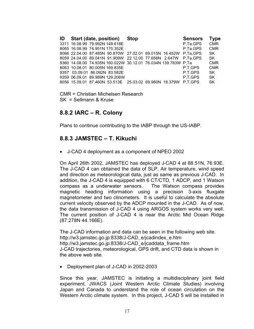
ID Start (date, position) Stop Sensors Type3311 16.08.99 79.992N 149.618E P,Ta,GPS CMR8065 16.08.99 74.951N 170.352E P,Ta,GPS CMR8066 22.04.00 87.485N 90.870W 27.02.01 69.015N 16.452W P,Ta,GPS SK8059 24.04.00 89.041N 91.909W 22.12.00 77.656N 2.647W P,Ta,GPS SK9360 14.08.00 74.935N 160.022W 30.12.01 76.034N 139.783W P,Ta CMR8063 10.08.01 80.005N 169.835E P,T,GPS CMR9357 03.09.01 86.092N 83.582E P,T,GPS SK9359 06.09.01 89.989N 129.206W P,T,GPS SK8056 15.09.01 87.460N 53.513E 25.03.02 69.980N 18.379W P,T,GPS SKCMR = Christian Michelsen ResearchSK = Sellmann & Kruse8.8.2 IARC – R. ColonyPlans to continue contributing to the <strong>IABP</strong> through the US-<strong>IABP</strong>.8.8.3 JAMSTEC – T. Kikuchi• J-CAD 4 deployment as a component of NPEO 2002On April 26th 2002, JAMSTEC has deployed J-CAD 4 at 88.51N, 76.93E.The J-CAD 4 can obtained the data of SLP, Air temperature, wind speedand direction as meteorological data, just as same as previous J-CAD. Inaddition, the J-CAD 4 is equipped with 6 CT/CTD, 1 ADCP, and 1 Watsoncompass as a underwater sensors. The Watson compass providesmagnetic heading information using a precision 3-axis fluxgatemagnetometer and two clinometers. It is useful to calculate the absolutecurrent velocity observed by the ADCP mounted in the J-CAD. As of now,the data transmission of J-CAD 4 using ARGOS system works very well.The current position of J-CAD 4 is near the <strong>Arctic</strong> Mid Ocean Ridge(87.278N 44.166E).The J-CAD information and data can be seen in the following web site.http://w3.jamstec.go.jp:8338/J-CAD_e/jcadindex_e.htmhttp://w3.jamstec.go.jp:8338/J-CAD_e/jcaddata_frame.htmJ-CAD trajectories, meteorological, GPS drift, and CTD data is shown inthe above web site.• Deployment plan of J-CAD in 2002-2003Since this year, JAMSTEC is initiating a multidisciplinary joint fieldexperiment, JWACS (Joint Western <strong>Arctic</strong> Climate Studies) involvingJapan and Canada to understand the role of ocean circulation on theWestern <strong>Arctic</strong> climate system. In this project, J-CAD 5 will be installed in17