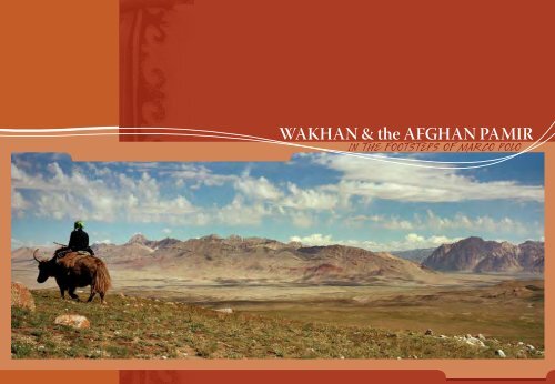
WAKHAN & the AFGHAN PAMIR - Aga Khan Development Network
WAKHAN & the AFGHAN PAMIR - Aga Khan Development Network
WAKHAN & the AFGHAN PAMIR - Aga Khan Development Network

You also want an ePaper? Increase the reach of your titles
YUMPU automatically turns print PDFs into web optimized ePapers that Google loves.
<strong>WAKHAN</strong> & <strong>the</strong> <strong>AFGHAN</strong> <strong>PAMIR</strong>IN THE FOOTSTEPS OF MARCO POLO
68ºE 70ºE 72ºE 74ºE38ºNWakhan & <strong>the</strong> Afghan PamirU Z B E K I S T A NDushanbe<strong>WAKHAN</strong> FACTSHIGHLIGHTS36ºNSnowcapped 7000mHindukush peaks beckontrue mountain loversKyrgyz nomads in <strong>the</strong> heartof <strong>the</strong> Afghan Pamir preservea vanishing way of lifeRare and spectacularwildlife roam isolated highelevation valleysSparkling mountain lakes ofZorkol and Chaqmaqtin feedCentral Asia’s mighty Oxus RiverAncient Silk Road caravanhistory inscribed in petroglyphsshowcases <strong>the</strong> archeologyKunduzT A J I K I S T A NTaluqanFaizabadIshkashimU KKhorogQazidehU S<strong>Khan</strong>dudNoshaq7492mHChitralQila-e PanjaSarhad-e BroghilP A K I S T A NGilgitsee route mapCountryAfghanistanProvinceBadakhshanDistrictWakhanNearest InTERNATIONAL AirportKabulNearest Domestic AirportFaizabadGateway TownIshkashimIRANTURKMENISTANUZBEKISTANSTANKAZAKHSTANKYRGYZSTANTAJIKISISTANCHINADistrict headquarters<strong>Khan</strong>dudMain VillagesQazideh, Qila-e Panja,Goz Khun, Sarhad-e Broghil34ºNN01000 20 40 60 80100200Kabul300 Kilometres200 MilesJalalabadKHYBERPASSPeshawarPAKISTANIslamabadINDIANEPALPopulationapproximately 12,000in 1500 householdsLanguagesPersian, Wakhi and Kyrgyz“We were glad to seek shelter from<strong>the</strong> keen air of <strong>the</strong>se breezyaltitudes in <strong>the</strong> felt tents of <strong>the</strong>Kyrgyz of <strong>the</strong> Afghan Pamir.”Sir Aurel Stein© 2006 Mareile Paley
DISCOVERING <strong>WAKHAN</strong><strong>WAKHAN</strong> IS A LAND SO REMOTE THAT FEW OUTSIDERS HAVE EVER VENTURED THERE. YET THROUGH <strong>WAKHAN</strong>FLOWED A VITAL BRANCH OF THE GRAND TRANS-ASIAN ARTERY KNOWN AS THE SILK ROAD, LINKING EAST TO WEST.PETROGLYPHS DEPICTING WARRIORS, HUNTING SCENES, CARAVANS AND BUDDHIST HISTORY, ALONG WITH THEOCCASIONAL RABOT OR TRAVELLERS’ SHELTER, BEAR SILENT WITNESS TO THE TRACKS OF TRADITION, AND OFFERTHE VISITOR A GLIMPSE INTO THE RICH HERITAGE OF PILGRIMS, CARAVANS AND ARMIES THAT ONCE TRAVERSEDTHIS CLASSIC ROUTE.“In <strong>the</strong> middle of <strong>the</strong> Pamir valley isa great dragon lake, clean and pure as amirror; <strong>the</strong> colour of <strong>the</strong> lake isdark blue and <strong>the</strong> taste of<strong>the</strong> water sweet and soft.”Hsuan TsangThe great explorers who visited Wakhan are still asource of inspiration and wonder for today’s intrepidtravellers – Hsuan Tsang, <strong>the</strong> 7th century Chinese monkwho went in search of Buddhist teachings; Marco Polo,who in <strong>the</strong> 13th century journeyed overland to China;Mirza Muhammad Haidar, who chronicled <strong>the</strong> MoghulEmpire in <strong>the</strong> 16th century; Lieutenant John Wood andLord Curzon, Englishmen who searched for <strong>the</strong> source of<strong>the</strong> Oxus River in <strong>the</strong> 19th century; Sir Aurel Stein, <strong>the</strong>20th century British archeologist who sought to unravel<strong>the</strong> Buddhist history of Innermost Asia; and mountaineerH.W. Tilman who sought unknown routes across <strong>the</strong>mountain ranges.Snowcapped peaks soar majestically above villagesand glaciers descend precipitously to feed raging riversin this land of immense scale, beauty and contrast. On<strong>the</strong> Afghan Pamir, <strong>the</strong> unimaginably wide open spacesseem to extend forever. Here you’re more likely to bumpinto a big-horned sheep or a brown bear than ano<strong>the</strong>rhuman being.Yet Wakhan is also home to hardy mountain people– Wakhi farmers and herders, who greet guests withunmatched hospitality – a warm smile, a cup of tea and abowl of yogurt – and <strong>the</strong> last remaining Kyrgyz nomads,whose welcoming yurts dot <strong>the</strong> fertile grasslands of <strong>the</strong>Afghan Pamir.THE <strong>AFGHAN</strong> <strong>PAMIR</strong>Pamir are unique U-shaped, high-elevation mountainvalleys distinctive to Central Asia, where <strong>the</strong>re are morethan half a dozen named pamir. Renowned as summergrazing grounds for <strong>the</strong>ir abundant grass and water,<strong>the</strong>se vast plateaus are covered by snow six monthsof <strong>the</strong> year.The Afghan Pamir include two such grasslands at <strong>the</strong>eastern end of Wakhan – <strong>the</strong> Big Pamir and <strong>the</strong> LittlePamir, which are better known by <strong>the</strong>ir Persian names.The Big Pamir or Great Pamir is called Pamir Kalanand Pamir-e-Buzurg (kalan and buzurg both mean‘great’ or ‘large’). The Little Pamir is called Pamir Khurdand Pamir-e-Kochak (khurd and kochak both mean‘little’ or ‘small’).The 60km long Big Pamir nestles between <strong>the</strong> Sou<strong>the</strong>rnAlichur Range to <strong>the</strong> north and <strong>the</strong> Wakhan Range to<strong>the</strong> south. The Little Pamir, at 100km long and 10kmwide, is actually larger in area than <strong>the</strong> Big Pamir, yet<strong>the</strong> more rugged Big Pamir has a higher elevation andso earns its name. The proper name ‘Pamirs’ typicallyrefers to <strong>the</strong> Central Asian mountain range that extendsfrom Tajikistan into Afghanistan and China.THE LANDAfghanistan’s Wakhan District is a narrow strip of landseparating Tajikistan and Pakistan that juts eastward some350km to meet <strong>the</strong> China border. Wakhan District has twodistinct parts – <strong>the</strong> Wakhan Corridor and <strong>the</strong> Afghan Pamir.All of Wakhan lies at elevations higher than 2000m and <strong>the</strong>Afghan Pamir lies above 3500m.The Wakhan Corridor is a deep valley formed by <strong>the</strong> Panj Riverthat courses between <strong>the</strong> 7000m peaks of <strong>the</strong> Hindukush to<strong>the</strong> south and <strong>the</strong> lofty mountains of Tajikistan to <strong>the</strong> north.Along <strong>the</strong> south bank of <strong>the</strong> Panj River and its upper tributary,<strong>the</strong> Wakhan River, are numerous Wakhi villages. The villagesbetween Ishkashim and Qila-e Panja are termed LowerWakhan. More than 5000m of vertical relief commands <strong>the</strong>sou<strong>the</strong>rn horizon of Lower Wakhan, where <strong>the</strong> valley is asbroad as 2km. The villages in Upper Wakhan between Qila-ePanja and Sarhad-e Broghil lie along <strong>the</strong> more narrow banksof <strong>the</strong> Wakhan River, which opens to a dramatic river basin3km wide at Sarhad-e Broghil. Streams fed by precipitousHindukush glaciers cut across <strong>the</strong> Wakhan Corridor and flowinto <strong>the</strong> main river.Three mountain ranges – <strong>the</strong> Hindukush, Karakoram andPamir – converge in Wakhan to form what is called <strong>the</strong>Pamir Knot. The Hindukush Range, which forms <strong>the</strong> borderwith Pakistan, has 38 summits higher than 7000m, includingAfghanistan’s highest peak Noshaq (7492m). Permanentsnow blankets Wakhan’s highest peaks. The high, open valleysbetween <strong>the</strong>se three mountain ranges form <strong>the</strong> Afghan Pamir,known in Persian as <strong>the</strong> Bam-e Dunya, or <strong>the</strong> “roof of <strong>the</strong>world,” which is home to Kyrgyz nomads.High passes called kotal transect <strong>the</strong> mountain ranges andwere used by armies and ancient trade caravans. In <strong>the</strong>Afghan Pamir, passes, although at high elevation, are relativelyeasy for people to cross. The passes across <strong>the</strong> more ruggedHindukush are more difficult. The key Hindukush passes are:Broghil Pass (3882m) and Darwaza Pass (4288m) to Chitral;Khodarg Werth (or Khora Bort Pass) to Ishkoman; and IrshadUween (4979m) and Dilisang Pass (5290m) to Gojal.All of Wakhan is a semi-arid zone. In <strong>the</strong> Wakhan Corridor,agriculture is only possible through irrigation, fed bymeltwater in <strong>the</strong> streams descending from <strong>the</strong> mountains.Apart from occasional clusters of shrubs or willow, birch ando<strong>the</strong>r small trees, <strong>the</strong> landscape is largely barren of vegetation.Above 3500m, <strong>the</strong> valleys widen onto <strong>the</strong> expansive AfghanPamir with its lush seasonal meadows, peaty soil, and vividblue lakes.THE MOTHER RIVERThe Amu Darya or “Mo<strong>the</strong>r River” is <strong>the</strong> Persian namefor <strong>the</strong> river that classical Greek geographers called <strong>the</strong>Oxus. It forms much of Afghanistan’s nor<strong>the</strong>rn borderwith Tajikistan and Uzbekistan and courses more than2400km across Central Asia to <strong>the</strong> Aral Sea. The AmuDarya, one of Afghanistan’s four major river systems,has its source in <strong>the</strong> icy heights of <strong>the</strong> Pamir Mountainsat <strong>the</strong> head of Wakhan’s Wakhjir Valley. Joined by <strong>the</strong>stream coming from Chaqmaqtin Lake south of BozaiGumbaz, it becomes <strong>the</strong> Wakhan River, which is metat Qila-e Panja by <strong>the</strong> Pamir River flowing from Zorkol.Downstream of Qila-e Panja, <strong>the</strong> river is called <strong>the</strong>Ab-e Panja (Panj River) and flows through a deep gorgeforming <strong>the</strong> border between Afghanistan’s BadakhshanProvince and Tajikistan. Finally, east of Kunduz, it’s joinedby Tajikistan’s Vaksh River and becomes <strong>the</strong> Amu Daryafor <strong>the</strong> remainder of its course across Central Asia.The Oxus is a river whose headwaters,“tell of forgotten peoples and secrets ofunknown lands, and are believed to haverocked <strong>the</strong> cradle of our race.”Lord Curzonwww.wakhan.org
<strong>WAKHAN</strong> ACTIVITIESA JOURNEY THROUGH <strong>WAKHAN</strong> IS THE VERY ESSENCE OF ADVENTURE TRAVEL. AROUND EVERY TURN IN THE ROADOR TRAIL ARE TANTALIZING MOUNTAINS, UNKNOWN WILDERNESS, AND FASCINATING VILLAGES AND NOMADCAMPS. WITH EVERY STEP DEEPER INTO THE MOUNTAINS, YOU DISCOVER A WHOLE NEW WORLD OF ADVENTURE.WALK ALONG THE ROAD, WANDER THROUGH VILLAGES, EXPLORE THE INVITING MOUNTAIN PASSES. TRAVEL WITHTHE GRACIOUS AND HOSPITABLE PEOPLE WHO LIVE HERE, SHARING THEIR HARDIHOOD. EXPERIENCING THESEMOUNTAINS FIRST-HAND IS INCOMPARABLE AND UNFORGETTABLE.Trekking, by far <strong>the</strong> most popular activity in Wakhan,is traditionally a multi-day overland journey on foot involving<strong>the</strong> support of a trek crew who transport your personalbelongings and gear such as tents, food and cookingequipment. Today’s trekking styles vary from backpackingwhere you carry everything yourself, trekking with porterswho transport your gear using pack animals (yak, donkey,camel or horse), buying an animal and leading it yourself(usually a donkey, hence <strong>the</strong> name donkey trekking), orhiring a tour operator who organises your trek.Distances in <strong>the</strong> Afghan Pamir are so great that youmay want to hop a ride during part of your trek (calledyak trekking). Yaks, strong shaggy beasts, are regularlyused by local people to transport gear, but are also funto ride and useful for crossing rivers ra<strong>the</strong>r than fording<strong>the</strong>m. In winter when rivers are frozen solid, it’s possiblefor intrepid travellers to move on <strong>the</strong>se icy pathways intraditional caravans of double-humped Bactrian camels.It’s more common, especially with Kyrgyz, to travelon horseback. Horse trekking, where your horse is yourtransportation vehicle and your travelling companion,allows you to move faster than on foot, relieves you ofhaving to transport gear separately, and also facilitatesnavigating river crossings and steep slopes. You can gohorse trekking even if you have little experience withhorses by hiring a horse trekking tour operator.The unique attractions for mountaineering inWakhan are several easily accessible 7000m peaks of <strong>the</strong>Hindukush, including Afghanistan’s highest peak Noshaq(7492m), and numerous peaks higher than 6000m awaitingfirst ascents. The glaciated side valleys in <strong>the</strong> Big Pamiroffer a host of virgin peaks. Extreme adventurers will find aplayground for climbing and ski mountaineering.The isolation and remoteness of Wakhan, its naturalbeauty, and its cultural diversity are ideal for culturaltouring in 4WD vehicles. Exploring <strong>the</strong> cultural heritage,meeting people on village walks, day hiking and untrammelledcamping each night combine to please <strong>the</strong> mostventuresome visitors.Unlimited opportunities for photography and discovering<strong>the</strong> rich natural history abound. Birdwatching,easily combined with o<strong>the</strong>r activities in Wakhan, is superb.Some of <strong>the</strong> best is along <strong>the</strong> Panj River and Wakhan Riveras you drive between Ishkashim and Sarhad-e Broghil. Theupland rivers and lakes are nesting grounds for geese,ducks and ibises, as well as spring and fall stopovers formigratory waterfowl and raptors. Marshy flats and oxbowlakes provide year-round habitat for many wading birds.The pristine natural environment boasts ideal wildlifeviewing where charismatic species such as Marco Polosheep (Ovis ammon polii), snow leopard (Uncia uncia), andbrown bear (Ursus arctos) make <strong>the</strong>ir home, particularly in<strong>the</strong> Wakhjir Valley and in <strong>the</strong> numerous side valleys of <strong>the</strong>Big Pamir. The whistling alarm call of ubiquitous long-tailedmarmots (Marmota caudata) alerts you to <strong>the</strong>ir presencebefore <strong>the</strong>y dive into <strong>the</strong>ir burrows. (Inadvertently steppinginto a marmot burrow may be <strong>the</strong> greatest physicaldanger for anyone trekking in <strong>the</strong> Afghan Pamir!) Greywolf, red fox, Afghan urial (Ovis orientalis), ibex (Capraibex), and o<strong>the</strong>r wild cats also thrive in this high and wildterrain. E<strong>the</strong>real and wonderfully unique butterflies gracesummer wildflowers.A few ambitious cyclists have already made <strong>the</strong>irway to Wakhan. The road through <strong>the</strong> Wakhan Corridoris <strong>the</strong>re for mountain biking, but you’d better be a goodbike mechanic and have an ample supply of spare partsand tires.Wakhan is an undiscovered, uncrowded gem notyet on <strong>the</strong> tourist map of <strong>the</strong> world. Cultivate a spirit ofadventure and open heartedness, and add to it self reliance,sound judgment and good planning and you have<strong>the</strong> recipe for an unforgettable trip to one of <strong>the</strong> earth’smost exotic landscapes.THE WEATHERWakhan is at its best during <strong>the</strong> short summer, whichlasts from late June to mid-September. It is followed by along winter from late September to early June with coldtemperatures and severe, snowy conditions characteristicof this subarctic mountain climate. Wakhan receivesfewer than 10cm of annual rainfall, much of it coming in<strong>the</strong> form of snowfall. Infamously fierce winds known asbad-e Wakhan blow throughout <strong>the</strong> year, fueling summerdust storms and winter blizzards. Unpredictable andchangeable wea<strong>the</strong>r is a given in <strong>the</strong> mountains, and it cansnow any month of <strong>the</strong> year in <strong>the</strong> Afghan Pamir.WHEN TO GOThe tourist season in Wakhan is relatively short, starting inMay or June and lasting until September or early October.From April to early June, melting snow swells rivers andhigh water blocks road access to many areas, making somerivers crossings impassable by foot, animal or vehicle.Many areas only become accessible as of early July. Thelater in summer you travel, <strong>the</strong> easier it is to cross streamsand rivers, and <strong>the</strong> greater <strong>the</strong> likelihood of being able todrive as far as Sarhad-e Broghil. August to mid-Septemberis <strong>the</strong> optimal travel time. By early September, however,snow can close trails and roads for <strong>the</strong> season.CULTURAL CONSIDERATIONSTHE RESPECTFUL TOURIST:behaves conservatively as a show of respect for <strong>the</strong> local cultureis humble and grateful when accepting offers of local food whilenot taking advantage of generous hospitality, and pays for foodand accommodationwears loose, long-sleeved, unrevealing shirts, and full-lengthpants that cover <strong>the</strong> ankleswearing a hat or scarf is optional for women travelling throughWakhi and Kyrgyz areas, but is advisable elsewhere in Badakhshandoesn’t drink alcohol in public viewrefrains from all public displays of affectioncontributes to <strong>the</strong> local economy by patronizing local businesses,hiring porters and buying local products, which encourages localpeople to conserve <strong>the</strong>ir natural resource baseasks permission before photographing people or sacred placesmakes donations through established organizations orrespected community leaders, and doesn’t give handouts tobeggars or childrenENVIRONMENTAL CONSIDERATIONSTHE RESPECTFUL TOURIST:lessens <strong>the</strong> negative impact on <strong>the</strong> environmenttravels in a small party to minimise overall impact, but avoidstravelling alonecooks on a kerosene stove avoiding wood or dung fires since<strong>the</strong>se fuels are a scarce resource that belong to <strong>the</strong> local peoplebrings adequate warm clothing to avoid relying on campfiresfor warmthba<strong>the</strong>s, washes dishes and clo<strong>the</strong>s with a basin and discardssoapy water at least 50m from water sourcesrelieves one’s self at least 50m from open water sources orcampsites since toilets don’t existburns rubbish that can be burnt and packs out o<strong>the</strong>r rubbishleaves campsites <strong>the</strong> same way <strong>the</strong>y were on arrival; doesn’tclear vegetation, cut trees, limbs or branches, and doesn’t moverocks from walls or canalsdoesn’t write names or mark graffiti on rocksdoesn’t hunt or trade in endangered speciesrefrains from harassing or feeding wildlife or eating wild gamepatronises tour operators who commit to environmentallyresponsible tourismTHE RESPECTFUL TOURIST:is law abiding and obtains necessary permission(s) for <strong>the</strong> routerespects <strong>the</strong> sovereignty of international borders and obtains allrequired permission for cross-border routestakes responsibility for one’s actions and avoids foolhardy decisionsRECOMMENDED ITINERARIESfrom IshkashimWITH ONE WEEKDrive to Sarhad-e Broghil enjoying beautiful scenery, village walks,diverse cultural exchanges, and visits to intriguing roadside tombs,shrines and petroglyphs.A shorter road trip as far as Qila-e Panja allows for a side tripto <strong>the</strong> confluence of <strong>the</strong> Pamir and Wakhan Rivers and a visitto Avgarch village.The spectacular route to Noshaq Base Camp offers world-classtrekking just an hour’s drive from Ishkashim.WITH TWO WEEKSTry one longer route to picturesque Zorkol in <strong>the</strong> Big Pamir,or to <strong>the</strong> nearest Kyrgyz camps in <strong>the</strong> Little Pamir.Combine two routes by traversing <strong>the</strong> Big Pamir starting fromGoz Khun to Zorkol, and <strong>the</strong>n to Sarhad-e Broghil in Upper Wakhan.Attempt a cross-border route from Sarhad-e Broghil in UpperWakhan to Pakistan’s Nor<strong>the</strong>rn Areas.WITH THREE WEEKSVisit Chaqmaqtin Lake in <strong>the</strong> Little Pamir and outlyingKyrgyz settlements.Enjoy wildlife viewing in <strong>the</strong> Little Pamir’s Wakhjir Valley.Combine routes by visiting <strong>the</strong> Big Pamir and more remoteareas of <strong>the</strong> Little Pamir.www.wakhan.org
<strong>WAKHAN</strong> & THE <strong>AFGHAN</strong> <strong>PAMIR</strong> ROUTESLOWER <strong>WAKHAN</strong>BIG <strong>PAMIR</strong>LITTLE <strong>PAMIR</strong>CROSS-BORDERNOSHAQ BASE CAMPDURATION 5-6 days round tripSTANDARD moderateSTART/FINISH Qazidehvisit base camp (4450m) of Noshaq (7492m), Afghanistan’shighest summit and second highest peak in <strong>the</strong> Hindukushsuperb close-up views of four 7000m peaksWakhan’s best short trektrailhead less than one hour’s drive from IshkashimUPPER <strong>WAKHAN</strong>QILA-E PANJA TO SARHAD-E BROGHIL (seeDURATION 3-4 days one waySTANDARD easySTART Qila-e PanjaFINISH Sarhad-e Broghilwalk along road visiting friendly Wakhi villagesalternative when road to Sarhad-e Broghilis blocked by landslides or floodsgood views of Baba Tungi (6513m)ideal for donkey trekkinghot spring in Sarhad-e Broghilon route map)BROGHIL PASS (see on route map)DURATION 1 daySTANDARD easySTART/FINISH Nirsbroad, grassy (3882m) pass on Afghanistan-Pakistan borderperfect for horseback ridinghistoric pass, lowest pass across Hindukush Rangeside trips to ancient forts above villages en routeWarning: Crossing <strong>the</strong> Broghil Pass into Pakistan is not permitted.www.wakhan.orgZORKOL RIVER ROUTE (see on route map)DURATION 8 days round tripSTANDARD moderateSTART/FINISH Goz KhunZorkol, largest lake in <strong>the</strong> Afghan Pamir (20km by 2-5km)stunning scenery along Pamir River with no passes to crosseasier and shorter route than Zorkol High Routeside trips possible to several side valleys linking to Zorkol High RouteZORKOL HIGH ROUTE (see on route map)DURATION 10 days round tripSTANDARD demandingSTART/FINISH Sargez or Wuzedchallenging route crosses three passes (4300m-4500m) each waywildlife watchingtrekking peak possibilitiesWakhi summer settlements and Kyrgyz campsROUTE DIFFICULTYEASY: trails below 3500m, 3-4 days500m daily elevation changeno pass crossings, no glacier travelMODERATE: trails below 4500m, less than 1 week1000m daily elevation changecross a pass below 4500mDEMANDING: trails below 5000m, 1 week or more1500m daily elevation changecross a pass below 5000mless than one day nontechnical glacier travelVERY DEMANDING: rugged trails below 5000m, 1 week or more2000m daily elevation changecross a glaciated pass above 5000mone day technical glacier travelKOTAL-E SHAUR (see on route map)DURATION 10 days round tripSTANDARD demandingSTART/FINISH Sarhad-e Broghillinks Upper Wakhan with Zorkoloption to link Big Pamir with Little Pamir routescross three passes each way: Daliz (4267m),Kotal-e Qarabel (4820m) and glaciated Kotal-e Shaur (4890m)impressive high mountain scenery from Kotal-e Shaur“There is nothing in my experience morefascinating than finding and crossing anunknown pass across a mountain range.The more important <strong>the</strong> watershed,geographically speaking, <strong>the</strong> moresatisfying <strong>the</strong> achievement.” Eric ShiptonKASHCH GOZ HIGH ROUTE (see on route map)DURATION 9-10 days round tripSTANDARD demandingSTART/FINISH Sarhad-e Broghilcross three passes each way: grassy Daliz (4267m),snow-covered Uween-e-Sar (4887m) andflower-carpeted Aqbelis (4595m)petroglyphs at Sang NevishtaWakhi summer settlements and Kyrgyz campsaccessible during summer when Kashch Goz River Routeis blocked by high waterKASHCH GOZ RIVER ROUTE (see on route map)DURATION 6-7 days round tripSTANDARD moderateSTART/FINISH Sarhad-e Broghilcross one pass each way: Daliz Pass (4267m)one day shorter than Kashch Goz High RouteWakhi winter settlements at Langar, and Kyrgyz campsroute along Wakhan River used only when low water and in winterCHAQMAQTIN LAKE (see on route map)DURATION 9-11 days round tripSTANDARD demandingSTART/FINISH Sarhad-e Broghilrenowned lake, source of Murghab River or Aksusecond largest lake (9km by 2km) in <strong>the</strong> Afghan Pamirfollow Kashch Goz High Route or River Route to Kashch Gozallow at least 1 day each way between Kashch Goz and lakeKyrgyz tombs at Bozai Gumbazseveral Kyrgyz camps along routehot springside trip to Tegermansu (3-4 days one way from ChaqmaqtinLake) and Kotal-e Tegermansu (4872m) on Afghanistan-Chinaborder, easternmost area of Little PamirWarning: All passes leading into Tajikistan and Chinaare strictly off-limits to foreigners.WAKHJIR VALLEY (see on route map)DURATION 14-16 days round tripSTANDARD demandingSTART/FINISH Sarhad-e Broghilsuperb wildlife viewing in upper Wakhjir Valleyremote wilderness of breathtaking beautyprimary source of <strong>the</strong> Oxus Riverfollow Kashch Goz High Route or River Route to Kashch GozWarning: The Wakhjir Pass (4927m) on <strong>the</strong> Afghanistan-Chinaborder is strictly off-limits to foreigners.“At Sarhad, <strong>the</strong> Oxus bursts from <strong>the</strong>gorge and, rejoicing in its freedom,spreads in meandering streams overa wide flat stony valley.” H.W. TilmanAnyone in search of real adventure will relish <strong>the</strong>world-class mountain travel opportunity of across-border route.Special permission for cross-border routes from<strong>the</strong> Little Pamir to Pakistan’s Nor<strong>the</strong>rn Areas isrequired from <strong>the</strong> governments of both Afghanistanand Pakistan in addition to obtaining visasfor both countries (see <strong>the</strong> Wakhan Travellers'Information insert for fur<strong>the</strong>r information).IRSHAD UWEEN (see on route map)DURATION 8-9 days one waySTANDARD demandingSTART Sarhad-e BroghilFINISH Chapursan Valley, Nor<strong>the</strong>rn Areas, Pakistanhistoric trading route from Little Pamir’s Bai Qara Valleyto Chapursan Valleycross one 4979m snow-covered, but nonglaciated passchallenging river crossingsmulti-coloured rock formationsallow 4 days between Kashch Goz and Baba GhundiDILISANG PASS (see on route map)DURATION 11-12 days one waySTANDARD very demandingSTART Sarhad-e BroghilFINISH Misgar, Nor<strong>the</strong>rn Areas, PakistanLittle Pamir’s Wakhjir Valley to Misgarcross one or three passes en route to Wakhjir Valleycross one 5290m glaciated pass on Afghanistan-Pakistan borderspectacular high mountain experienceside trip to head of Wakhjir Valley (2-3 days)
THE PEOPLETHE WAKHIFor more than 2500 years <strong>the</strong> Wakhan Corridor has been<strong>the</strong> homeland of Wakhi people, who refer to <strong>the</strong>mselvesas Wakhik or Khik. Today about 10,000 Wakhi live inAfghanistan’s Wakhan District, with ano<strong>the</strong>r 40,000 living inadjacent areas of Tajikistan, Pakistan and China. Wakhi live inyear-round villages extending from Qazideh (2800m) at <strong>the</strong>western end of Lower Wakhan to Sarhad-e Broghil (3300m) at<strong>the</strong> eastern end of Upper Wakhan. Wakhi people are farmers,who cultivate wheat, barley, peas, potatoes and a few apricottrees at <strong>the</strong> upper limits of agriculture, where production israrely sufficient. Chinir, a festival celebrating <strong>the</strong> start of <strong>the</strong>barley harvest, occurs around <strong>the</strong> first week of August. Wakhidepend on livestock to supplement <strong>the</strong>ir agriculture, andalmost all households have some animals. Wealthier familieshave many sheep, goats and yaks along with a few camels,horses and donkeys. Every summer, Wakhi people take <strong>the</strong>irlivestock to summer pastures as high as 4500m, where <strong>the</strong>animals grow fat on abundant grass. Wakhi people speakWakhi, which <strong>the</strong>y call Khikwor. It belongs to <strong>the</strong> Pamir groupof Iranian languages and is spoken throughout Wakhan. Mostmen also speak Persian, which is used as a link language tocommunicate with people from o<strong>the</strong>r parts of Afghanistan.Wakhi people are Isma’ili Muslims, whose spiritual leader is<strong>the</strong> <strong>Aga</strong> <strong>Khan</strong>.Here could go a captionTrek to Tegermansu Valley.KUCHThe annual seasonal migration, or kuch, of Wakhi people and<strong>the</strong>ir livestock to and from summer pastures is a colorful sight.Yaks piled high with cauldrons, bedding and household goodsmove along <strong>the</strong> trail, while large mastiff-like dogs trot beside<strong>the</strong>m. Wakhi women, swa<strong>the</strong>d in red scarves and shawls, rideon yaks and camels with young children clinging behind <strong>the</strong>irmo<strong>the</strong>rs. Infants ride in cloth-draped cradles perched on <strong>the</strong>backs of yaks and <strong>the</strong> men walk alongside, leading <strong>the</strong> yaks, orride on horses.The spring migration usually departs from <strong>the</strong> villages in<strong>the</strong> first week of June. During <strong>the</strong> summer, <strong>the</strong> kuch movesprogressively upvalley to higher grazing areas, and in autumn<strong>the</strong>y retrace <strong>the</strong>ir routes downvalley. The joyous returnmigration arrives in <strong>the</strong> villages in <strong>the</strong> second or third weekof October. Travellers may encounter <strong>the</strong>se caravans in <strong>the</strong>Afghan Pamir, especially on trails leading to and from <strong>the</strong>Little Pamir.© 2004 John MockTHE KYRGYZCentral Asia’s Altai mountains along <strong>the</strong> western border ofMongolia are <strong>the</strong> traditional home of <strong>the</strong> Kyrgyz, a Turkicpastoral nomadic group. Each summer, small bands ofKyrgyz would migrate from lower valleys in Central Asia to<strong>the</strong> Afghan Pamir, but following <strong>the</strong> 1917 Soviet revolution,several thousand Kyrgyz settled permanently in <strong>the</strong> Big Pamirand Little Pamir. Their once wide-ranging migration becamea series of short, seasonal movements within <strong>the</strong> closedfrontiers of <strong>the</strong> high-altitude Afghan Pamir. Kyrgyz live in feltyurts or oey, which <strong>the</strong>y move seasonally according to availablepasture, sunlight and shelter from wind. Their settlements liebetween elevations of 4000m and 4500m. The Kyrgyz tendherds of fat-tailed sheep, goats, yaks and Bactrian camels,and trade with Wakhi neighbors or travelling merchants forall <strong>the</strong>ir needs not supplied by <strong>the</strong>ir livestock. Following <strong>the</strong>Soviet-backed 1978 coup in Afghanistan, some 1300 Kyrgyz,led by Haji Rahman Qul, left <strong>the</strong> Afghan Pamir for Pakistan.In 1982 this group of Kyrgyz was resettled in <strong>the</strong> mountainsof eastern Turkey. Today, about 1400 Kyrgyz remain in <strong>the</strong>Afghan Pamir. Their language is also called Kyrgyz, which isfrom <strong>the</strong> Kipchak group of northwestern Turkic languages.Most Kyrgyz men also speak Wakhi. Like all Turkic people,Kyrgyz are Sunni Muslims.www.wakhan.org8“It was a delightfully cosy yurt, carpetedwith bright felt rugs. Plenty of embroideredcushions and o<strong>the</strong>r fineries attested <strong>the</strong>owner’s wealth and comfort.”Sir Aurel Stein
<strong>WAKHAN</strong> ACROSS THE CENTURIESTHE UPPER AMU DARYA REGION HAS BEEN POPULATED FOR MORE THAN 2500 YEARS, AND <strong>WAKHAN</strong> HAS RECEIVEDVISITORS FOR NEARLY AS LONG. THE SILK ROAD, WHICH LINKED ANCIENT CHINA WITH THE MEDITERRANEAN,PASSED THROUGH <strong>WAKHAN</strong> AND WAS IN CONTINUAL USE FROM 100 B.C. UNTIL THE 8TH CENTURY A.D.Both Chinese and Tibetan records mention Wakhanas a kingdom, and both powers contested <strong>the</strong> regionand its rich trade during <strong>the</strong> 7th and 8th centuries. Tradebrought <strong>the</strong> first known European traveller to <strong>the</strong> areain <strong>the</strong> 13th century, <strong>the</strong> Italian voyager Marco Polo whofirst mentioned <strong>the</strong> big-horned sheep that bear his name.Mirza Muhammad Haidar, a member of <strong>the</strong> Moghuldynasty that controlled Kashgar and India, completed hisTarikh-i-Rashidi in 1545, in which he described his travelsthrough Wakhan, which he knew as a part of Badakhshan.Benedict de Goës, a Jesuit, apparently travelled throughWakhan on his way from India to China in 1603, althoughhe did not specifically mention Wakhan.British accounts of <strong>the</strong> early 19th century mentionWakhan as a remote and little known mountain state whoseruler was a vassal of <strong>the</strong> Mir of Badakhshan. LieutenantJohn Wood of <strong>the</strong> British Navy was sent to survey <strong>the</strong>upper Amu Darya, seeking <strong>the</strong> source of <strong>the</strong> Oxus River,and reached Wakhan in January 1838. Wood found <strong>the</strong>ruler impoverished from taxes imposed by Badakhshan,<strong>the</strong> land insufficient in grain production with livestock <strong>the</strong>only wealth, and reached Zorkol, which he identified as<strong>the</strong> source of <strong>the</strong> Oxus. The British sent a series of nativeexplorers or ‘pandits’ through Wakhan between 1860 and1870, and in 1873, a British mission visited Wakhan andmet Mir Fateh Ali Shah and his son, Ali Murdan Shah.The mission noted Wakhan’s relations through marriagewith neighboring princely states of Shugnan and Kanjut(Hunza). At that time Wakhan encompassed both banksof <strong>the</strong> Panj River and its two upper tributaries, <strong>the</strong> PamirRiver and Wakhan River.www.wakhan.orgThe geopolitical rivalry between Great Britainand Russia, known as “The Great Game,” led to <strong>the</strong>dissolution of <strong>the</strong> principality of Wakhan at <strong>the</strong> end of <strong>the</strong>19th century and <strong>the</strong> formation of new borders. Wakhanbecame in effect a buffer zone separating <strong>the</strong> British andRussian empires. Subsequent geopolitical events of <strong>the</strong>20th century resulted in closed borders with <strong>the</strong> SovietUnion and China, leaving Wakhan District cut off andisolated. The Soviet occupation of Afghanistan and <strong>the</strong>subsequent civil war and Taliban rule kept Wakhan closedto travellers from 1979 until <strong>the</strong> establishment of <strong>the</strong>Karzai government in 2002.The people of Wakhan welcome travellers and arelooking to tourism to spur <strong>the</strong>ir economic growth andprosperity in <strong>the</strong> 21st century.Numerous rock carvings bear silentwitness to <strong>the</strong> tracks of traditionthat traverse Wakhan.“In <strong>the</strong> middle of <strong>the</strong> Pamir valley isa great dragon lake, clean and pure as amirror; <strong>the</strong> colour of <strong>the</strong> lake isdark blue and <strong>the</strong> taste ofPristine alpine <strong>the</strong> water landscapes sweet and are soft.” home toWakhan’s emblematic wildlife.Hsuan Tsang© 2004 John Mock<strong>WAKHAN</strong> TRAVELLERS’ INFORMATIONWakhan is a destination for <strong>the</strong> truly intrepid traveller. This planninginformation will help you begin your trip of a lifetime. To travel in Wakhan,you need good planning, sound judgment, and self-reliance. Recognise <strong>the</strong>limits of your own abilities and how best to integrate your knowledge andexperience to make sound decisions. Most of all, travelling in Wakhan callsPublished by <strong>the</strong> <strong>Aga</strong> <strong>Khan</strong> Foundation-Afghanistan, an agency of <strong>the</strong> <strong>Aga</strong> <strong>Khan</strong><strong>Development</strong> <strong>Network</strong>, www.akdn.orgAll rights reserved. No part of this publication may be copied, used, reprinted or soldwithout <strong>the</strong> written permission of <strong>the</strong> publisher.TEXT by John Mock & Kimberley O’Neil, www.mockandoneil.comDESIGN & LAYOUT by Kactus Design Ltd., www.kactusdesign.comPRINTING by Colorline, www.colorline.com.pkText © 2005 John Mock & Kimberley O’NeilMaps © 2006 Mareile Paley, info@paleyphoto.comIllustrations © 2006 Kactus Design Ltd.Photography © 2005 Matthieu Paley, www.paleyphoto.com, except where notedVisit www.wakhan.org for updated Wakhan travellers’ information.ENGLISHHow are you (doing)?I’m fineHow are you?I’m wellWhere are you going?What is your name?My name is ...What is that?I’m tiredSit downDrink teaEat foodGo!for a spirit of adventure and an open-hearted sense of humour.Everything is changing quickly in Afghanistan and Wakhan, so pleasedo your own research by checking directly with embassies, airlines,tourist offices and tour operators for <strong>the</strong> most current informationand costs. Costs are particularly vulnerable to change, so use <strong>the</strong> costshere as a guideline for budgeting purposes only.GREETINGShello (peace be with you)and with yougoodbye (God be with you)WAKHIchiz hol he?bidurt emtut sīyeta?wuzem sīyetkumeret takh?tī nunge chīst?zhu nunge ...yāoī chīz?washk vitknezditachoī pevshapīk yāochowVISASA visa stamped in your passport permits you to enter and travel inAfghanistan for a specific period of time. You can apply for a tourist visa atany Afghanistan embassy or consulate. A single-entry tourist visa is typicallyvalid for one month from <strong>the</strong> date of arrival in Afghanistan. Visa requirementsand fees vary according to length of stay and nationality and can changewithout notice, so first check with any Afghan embassy or consulate, visaservice or reputable travel agency.asalaam alekumwa alekum salaamkhuda hafizKYRGYZabalëngëz qanday?jaqshëözüungüz qandaysëz?jaman emeskayda barasëz?atëngëz kim?menim atim ...Bul emne?men ajëzolturunguzich chayjhe tamaqket<strong>WAKHAN</strong> PERMISSIONSpecial permission is required for travel anywhere in Wakhan District– essentially anywhere beyond (east of) Ishkashim. This permission is notrequired for travel elsewhere in Badakhshan Province outside WakhanDistrict. No separate trekking permit is required.The “Wakhan permission” takes <strong>the</strong> form of a handwritten letter in Persianfrom <strong>the</strong> commandant in Ishkashim, currently Wahid <strong>Khan</strong>. The letter muststate you have permission to visit Wakhan and <strong>the</strong> Afghan Pamir if you intendto visit ei<strong>the</strong>r <strong>the</strong> Big Pamir or Little Pamir. You may be asked by authorities toshow this letter at various places, but most certainly at <strong>the</strong> checkpost in Qila-eENGLISHyes/noWhere is ... available?I need ...how?how much/many?what?when?where?who?day/nightmorning/eveningyesterday/today/tomorrowbeautifulfirehouse (yurt)mountainPanja and in Sarhad-e Broghil (authorities find you in <strong>the</strong> village). If you don’thave a letter, you will be sent back to Ishkashim.To request permission, contact <strong>the</strong> Afghan Tourism Organization (ATO)who will coordinate with government ministries as needed and issue a typewrittenletter that you must <strong>the</strong>n take to Wahid <strong>Khan</strong>’s office when you arrivein Ishkashim. ATO’s main office (telephone 0093-020-2300-338, mobile0093-0-70673560) is near Kabul International Airport on <strong>the</strong> right-hand siderockstream (glacial/clear)WAKHIyan/net... esh kumer goten?mārey ... dirkortse sokht?tsumar?chīz?tsogdar?kumar?kui?ror/naghdsahār/purzyezī/wothg/pīgākhushruirakhnīghkhunkohof <strong>the</strong> road 100m before <strong>the</strong> roundabout when coming from <strong>the</strong> city. ATO alsostaffs a desk at <strong>the</strong> airport in <strong>the</strong> waiting hall just after customs clearance.Please keep in mind that tourism in Afghanistan is in its initial stages. Whiletourism policy evolves and ATO and <strong>the</strong> ministries develop <strong>the</strong>ir capabilitiesfur<strong>the</strong>r, <strong>the</strong> <strong>Aga</strong> <strong>Khan</strong> Foundation-Afghanistan (tel 873-763-631-488) House43, Street 13, Wazir Akbar <strong>Khan</strong>, Kabul) is willing to facilitate requests.gardur/zheravCROSS-BORDER PERMISSIONA visa for a country does not constitute “permission” to cross anKYRGYZoshondoy/joq... di qayerden?magha ... kerekqancha pul/turat?bul emne?qachan?qachan?qayerde?kit?kun/tunerteng menen/kechkechee/bügün/ertengsupuotoeytoointernational border where <strong>the</strong>re is no legal border crossing or immigrationcheckpost. Foreigners must request special permission from <strong>the</strong> governmentsof both countries for such an international border crossing. The “specialpermission” constitutes permission to exit one country at a given location,and permission to enter ano<strong>the</strong>r country at a given location with notation ofwhere foreigners will handle immigration formalities.too tekdarëyaIn Afghanistan, contact ATO. In Pakistan, contact <strong>the</strong> Government ofPakistan, Ministry of Tourism (email secretary@tourism.gov.pk, telephone 92-51-9213642, fax 92-51-9215912), Green Tower Trust, 11th floor, Blue Area,Islamabad, Pakistan.ENGLISHtrailwatergood/badleft/rightcold/hotrain/sunsnow1234567891050100Warning: Foreigners who attempt a cross-border route without explicitpermission for that route are subject to being shot at, taken into custody byauthorities, and accused of spying or smuggling. Such foolhardy decisions cannot only create an international incident, but also run <strong>the</strong> risk that authoritiesmay fur<strong>the</strong>r restrict access to <strong>the</strong>se border areas for everyone.WAKHIvidekhyupkbaf/shakchap/rostsur/thinmor/yīrzemGETTING THERE – TO <strong>AFGHAN</strong>ISTANBy AirAfghanistan’s capital Kabul has regional air links with its neighbouringcountries of Iran (Tehran), Tajikistan (Dushanbe), China (Urumqi) and Pakistan(Islamabad, Quetta), but lacks air links with Turkmenistan and Uzbekistan.yīubuītroītsaburpānzshāthhubhāthnaothasbuwista thasyīsadInternational flights to Kabul also operate from India (Delhi, Amritsar),United Arab Emirates (Dubai, Sharjah), Saudi Arabia (Jeddah, Riyadh), Kuwait(Kuwait City), Turkey (Istanbul, Ankara), Russia (Moscow) and Germany(Munich, Frankfurt).KYRGYZjolusujhakshi/jhamansolgo/ongghoötösuuq/isikjamghër/kunqarBy RoadForeigners can enter Afghanistan by road from Iran (Mashad to Herat),Pakistan (Peshawar to Kabul via <strong>the</strong> Khyber Pass), and Tajikistan’s GornoBadakhshan Autonomous Oblast (at Ishkashim). The Ishkashim bordercheckpost is a two-hour drive from Khorog, which has air links with Dushanbe,or a two-day road trip from Dushanbe.birekiüchtörtbeshaltëjetisegiztoghuzonelüübir jüzTurkmenistan, Uzbekistan (<strong>the</strong> road Hairatin to Mazar-e Sharif is only opento “official” traffic), and China do not have any road links open to foreigners.The Afghanistan-China frontier is a military zone, which is strictly off-limits.
The Norwegian Ministry of ForeignAffairs and GTZ support <strong>the</strong> Wakhantourism development program, whichis being implemented by <strong>the</strong> <strong>Aga</strong><strong>Khan</strong> Foundation - Afghanistan.German Technical CooperationThe <strong>Aga</strong> <strong>Khan</strong> <strong>Development</strong> <strong>Network</strong> (AKDN) is a groupof development agencies working in health, education,culture and rural and economic development, primarilyin Asia and Africa. It is dedicated to improving livingconditions and opportunities for <strong>the</strong> poor, withoutregard to <strong>the</strong>ir faith, origin or gender.AKDN has been active in Afghanistan since 1996 andis now undertaking a range of development initiativesaddressing issues of food security, infrastructurerehabilitation, upgrading and support for healthcareand educational institutions, water and sanitation,revitalization of cultural assets and urban development.<strong>Network</strong> activities are also responding to <strong>the</strong> need forinvestment in priority sectors of <strong>the</strong> economy such asmicrofinance, telecommunications and tourism.Through <strong>the</strong> integrated efforts of its agencies,institutions, and affiliates – and in cooperation with awide range of international and local partners – AKDNhas made significant achievements in its long-termcommitment to <strong>the</strong> reconstruction and developmentof Afghanistan.www.wakhan.orgKyrgyz womanwith newborn.