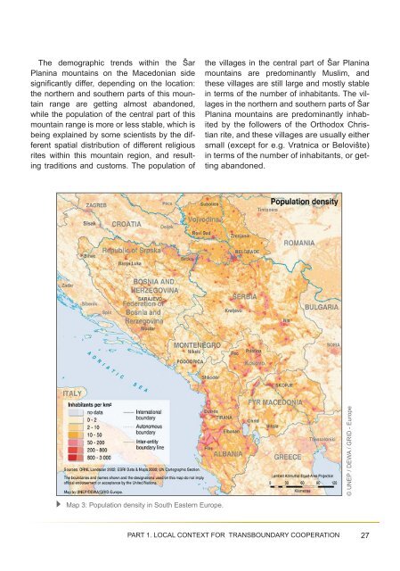
The demographic trends within the ŠarPlanina mountains on the Macedonian sidesignifi cantly differ, depending on the location:the northern and southern parts of this mountainrange are getting almost abandoned,while the population of the central part of thismountain range is more or less stable, which isbeing explained by some scientists by the differentspatial distribution of different religiousrites within this mountain region, and resultingtraditions and customs. The population ofthe villages in the central part of Šar Planinamountains are predominantly Muslim, andthese villages are still large and mostly stablein terms of the number of inhabitants. The villagesin the northern and southern parts of ŠarPlanina mountains are predominantly inhabitedby the followers of the Orthodox Christianrite, and these villages are usually eithersmall (except for e.g. Vratnica or Belovište)in terms of the number of inhabitants, or gettingabandoned.© <strong>UNEP</strong> / DEWA / GRID - EuropeMap 3: Population density in South Eastern Europe.PART 1. LOCAL CONTEXT FOR TRANSBOUNDARY COOPERATION 27
The above disparities in the spatial distributionof the population among differentparts are well illustrated by the demographicdata and trends concerning the villages insidethe area proposed for the planned ŠarPlanina National Park. According to the previousproposal for the national park designationits territory was expected to encompassthe territories of seven municipalities,however all six still inhabited mountain settlementsin this area belonged to only threemunicipalities. These were the four relativelybig villages of Vejce (381 inhabitants), Bozovce(1 012), Brodec (553) and Vesala (1045) in the municipality Tetovo (thus locatedin the central part of Šar Planina mountains),only one village of Gorno Jelovce (only 2 inhabitantsin 1 household, while remaining 15houses were abandoned) in the municipalityof Gostivar (in the southern part of ŠarPlanina mountains), and one village of Duf(55 inhabitants in 11 households, while 64remaining houses were abandoned) in themunicipality of Mavrovo-Rostuše (again inthe southern part of Šar Planina mountains).In total the population of these six mountainvillages proposed for inclusion intothe planned Šar Planina National Park accountedfor 3 048 in 438 households (whileas many as 98 houses were abandoned).Over 98.1 per cent of the population inhabitingthis area concentrated in the centralpart of the Šar Planina mountains (in Tetovomunicipality), while the population belongingto the municipalities of Mavrovo-Rostušeand Gostivar located in the southern part ofthis mountain range accounted for only 1.8percent and some 0.06 per cent of the totalpopulation. The remaining four Macedonianmunicipalities (Jegunovce, Tearce, Bogovinjeand Vrapchište) were expected to contributeto the proposed national park solely withtheir uninhabited mountain areas.In the Korab - Dešat region the situationis different. During the second half of the20-th century almost all villages in the northernpart of Korab - Dešat region were eitherabandoned or not growing in size (thesevillages were geographically and culturallyconnected to the southernmost part of ŠarPlanina, therefore the demographic trendswere similar). At the same time the villagespredominantly inhabited by the MacedonianMuslims, who settled in the central part of theKorab mountain massif and in the southernpart of this region (Dešat mountains) wereinitially growing in size. However, during thelast two decades these villages experiencedthe same fate as in the case of their northernneighbours <strong>–</strong> the rapid exodus of the mountainrural population, and migration in searchfor employment, e.g. to Italy.It should be mentioned that the territory ofthis southernmost part of the proposed transboundaryprotected area in Mavrovo NationalPark is inhabited by a true mixture of peopleof different ethnic groups and religions: MacedonianMuslims, Albanian Muslims, MacedonianChristians and Albanian Christians.To summarise - in general, the demographicsituation of the local populationson each side of the state borders is similar,characterised by its low size and density ofpopulation, negative demographic trends,population ageing, migration to towns pairedby rural depopulation.28Feasibility Study: SHARR/ ŠAR PLANINA - KORAB - DESHAT/DEŠAT
- Page 1 and 2: FEASIBILITY STUDYON ESTABLISHING A
- Page 3 and 4: Table of ContentsEXECUTIVE SUMMARY
- Page 5 and 6: EXECUTIVE SUMMARYThe region of the
- Page 7 and 8: But this will only be possible unde
- Page 9 and 10: Map 1: Mountains in the Dinaric Arc
- Page 11 and 12: and the associated North Atlantic T
- Page 13 and 14: © UNEP / DEWA / GRID - EuropeMap 2
- Page 15 and 16: © Pier Carlo Sandei2nd sub-regiona
- Page 17 and 18: The interior of the older church in
- Page 19 and 20: The authorities responsible for bor
- Page 21 and 22: itants and stronger surveillance of
- Page 23 and 24: oundary cooperation in Sharr/Šar P
- Page 25 and 26: ineffective control on the use of n
- Page 27: 1.2.2. Local demographic contextThe
- Page 31 and 32: © Google EarthSatellite view 1: Cu
- Page 33 and 34: The holiday resorts of the region a
- Page 35 and 36: The territory of Mavrovo National P
- Page 37 and 38: © Ljupco MelovskiBogovinsko Ezero
- Page 39 and 40: © Ljupco MelovskiBurning of junipe
- Page 41 and 42: e excused by e.g. important subsist
- Page 43 and 44: “Uncontrolled hunting” is in fa
- Page 45 and 46: of traditional land use practices,
- Page 47 and 48: Satelite view 5: the region of plan
- Page 49 and 50: © Dr. Slavsho Hristovski (Institut
- Page 51 and 52: © Ljupco Melovski© Ljupco Melovsk
- Page 53 and 54: ssp. integer, Hypericum umbellatum,
- Page 55 and 56: View from Bistra (Karbula) over De
- Page 57 and 58: © Border delineation: Google Earth
- Page 59 and 60: 2.2. Legal and administrative frame
- Page 61 and 62: The legal powers and duties delegat
- Page 63 and 64: (Kosovo - UN administered territory
- Page 65 and 66: landscape protection, and conservat
- Page 67 and 68: The spatial planning documentation
- Page 69 and 70: 2.3. Comparison of protected area n
- Page 71 and 72: © Ministry of Environment and Phys
- Page 73 and 74: Council resolution 1244/99). Unfort
- Page 75 and 76: © Ministry of Environment and Spat
- Page 77 and 78: © Mavrovo National Park websiteMap
- Page 79 and 80:
the state border, at the boundary o
- Page 81 and 82:
2.5.2. Planned new protected areasi
- Page 83 and 84:
© Ministry of Environment, Forests
- Page 85 and 86:
© Ljupčo MelovskiView from Kobili
- Page 87 and 88:
© Ljupčo MelovskiTitov Vrv (2747
- Page 89 and 90:
partial/active protection, buffer a
- Page 91 and 92:
© BFSD - Balkan Foundation for Sus
- Page 93 and 94:
transboundary cooperation between a
- Page 95 and 96:
Brushtla - peat bogs below the Kepi
- Page 97 and 98:
It should be noted here that none o
- Page 99 and 100:
• Rhododendro-Pinetum peucis,•
- Page 101 and 102:
stronghold for several threatened f
- Page 103 and 104:
Table 2. Tentative list of proposed
- Page 105 and 106:
Therefore, the presence of habitats
- Page 107 and 108:
- Stiftung Europäisches Naturerbe
- Page 109 and 110:
tected area belong to the less deve
- Page 111 and 112:
and sustainable development of thei
- Page 113 and 114:
• Common management planning, inc
- Page 115 and 116:
Developing the harmonised and compa
- Page 117 and 118:
It should be noted with concern tha
- Page 119 and 120:
ongoing cooperation to e.g. the Gov
- Page 121 and 122:
and sewage management, increased tr
- Page 123 and 124:
MAIN SOURCES OF INFORMATION1. Agenc
- Page 125 and 126:
43. Stevanovic, V., Jovanovic, S.,
- Page 127 and 128:
ACRONYMS AND ABBREVIATIONSADA Austr
- Page 129 and 130:
ACKNOWLEDGEMENTSThis study was prep
- Page 131 and 132:
DISCLAIMER:The contents of this vol