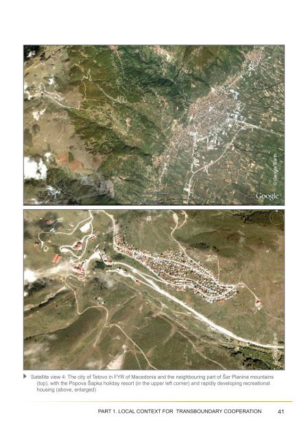
© Google Earth© Google EarthSatellite view 4: The city of Tetovo in FYR of Macedonia and the neighbouring part of Šar Planina mountains(top), with the Popova Šapka holiday resort (in the upper left corner) and rapidly developing recreationalhousing (above, enlarged)PART 1. LOCAL CONTEXT FOR TRANSBOUNDARY COOPERATION 41
“Uncontrolled hunting” is in fact illegal, andvery close to poaching, while poaching itselfis a crime, in all European countries. Furthermore,poaching on animals like the brown bear(Ursus arctos, listed as a “priority” species underHD Annex II), or wolf (Canis lupus, listed asa “priority” species under HD Annex II), or lynx(Lynx lynx, listed under HD Annex II), or therare Balkan subspecies of chamois (Rupicaprarupicapra balcanica, listed under HD Annex II) isin fact a crime against the common Europeanand global biodiversity conservation priorities.Therefore, proclaiming the legal protectionof new areas in the Sharr/Šar Planina,Korab, and Dešat/Deshat mountains pairedby increased operational capacities of theforestry and park rangers could possiblyprevent or mitigate further damages to thebiological diversity of the region, caused byhuman activities such as illegal forest fellingand timber harvesting, inducing forest fi res,dumping trash, overusing the resources ofmedicinal and aromatic plant species, or killingthe animal and bird species of the commonEuropean conservation importance.As for today, the tourist pressure on theSharr/Šar Planina, Korab and Dešat/Deshatmountains is for many reasons negligible. Firstly,the accommodation capacity of the very fewmountain resorts is limited, compared to thesize of the region. Additionally, the vast majorityof mountaineering huts in Sharr/Šar Planinamountains were destroyed in the times of therecent armed ethnic confl ict, while some previouslyinhabited mountain settlements and villagesremain abandoned until today. The commonfear of “criminal gangs and landmines” inthe border areas after the confl ict of 2001 considerablylimited the mountaineering activitiesand the number of both national and internationalvisitors to the most popular holiday resortsof the region (this is e.g. why the cable carto Popova Šapka skiing resort is out of operation,and many tourist accommodations havemainly the vacant rooms).Another potential threat to the environmentand biodiversity of the Sharr/Šar Planina - Korab- Dešat/Deshat region is the uncontrolledland development, either in the vicinity of thepresent settlements, or in the mountain locationsmost attractive for tourism and recreation.These illegal activities are to a large extentfacilitated in some areas of the region by theabsence of valid land development plans. Theuncontrolled land development in mountain areasof the region for the purposes of either residentialor recreational housing, or large touristinfrastructure projects would even acceleratethe current management problems and threatsto environment resulting from e.g. the adverseeffects of insuffi cient sewage treatment andsolid waste management, the limited capacitiesof the water supply systems, possible costsand negative effects of extracting even morewater from the mountain streams, underdevelopedroad network in the mountains, or thesoil erosion near the construction sites and onthe ski slopes.The pressure on uncontrolled land developmentis the highest in the vicinity of theexisting mountain holiday resorts, where thelocal inhabitants or external investors tryto develop either new overnight accommodationfacilities for tourists, or recreationalhouses for their own pleasure. Thus, thispressure is in general limited to the few locationsin areas already developed for tourismand recreation, namely the winter and summersports resort Brezovica-Shtrpce in Kosovo- UN administered territory under UNSecurity Council resolution 1244/99, PopovaShapka near Tetovo and Mavrovo in theFYR of Macedonia.42Feasibility Study: SHARR/ ŠAR PLANINA - KORAB - DESHAT/DEŠAT
- Page 1 and 2: FEASIBILITY STUDYON ESTABLISHING A
- Page 3 and 4: Table of ContentsEXECUTIVE SUMMARY
- Page 5 and 6: EXECUTIVE SUMMARYThe region of the
- Page 7 and 8: But this will only be possible unde
- Page 9 and 10: Map 1: Mountains in the Dinaric Arc
- Page 11 and 12: and the associated North Atlantic T
- Page 13 and 14: © UNEP / DEWA / GRID - EuropeMap 2
- Page 15 and 16: © Pier Carlo Sandei2nd sub-regiona
- Page 17 and 18: The interior of the older church in
- Page 19 and 20: The authorities responsible for bor
- Page 21 and 22: itants and stronger surveillance of
- Page 23 and 24: oundary cooperation in Sharr/Šar P
- Page 25 and 26: ineffective control on the use of n
- Page 27 and 28: 1.2.2. Local demographic contextThe
- Page 29 and 30: The above disparities in the spatia
- Page 31 and 32: © Google EarthSatellite view 1: Cu
- Page 33 and 34: The holiday resorts of the region a
- Page 35 and 36: The territory of Mavrovo National P
- Page 37 and 38: © Ljupco MelovskiBogovinsko Ezero
- Page 39 and 40: © Ljupco MelovskiBurning of junipe
- Page 41: e excused by e.g. important subsist
- Page 45 and 46: of traditional land use practices,
- Page 47 and 48: Satelite view 5: the region of plan
- Page 49 and 50: © Dr. Slavsho Hristovski (Institut
- Page 51 and 52: © Ljupco Melovski© Ljupco Melovsk
- Page 53 and 54: ssp. integer, Hypericum umbellatum,
- Page 55 and 56: View from Bistra (Karbula) over De
- Page 57 and 58: © Border delineation: Google Earth
- Page 59 and 60: 2.2. Legal and administrative frame
- Page 61 and 62: The legal powers and duties delegat
- Page 63 and 64: (Kosovo - UN administered territory
- Page 65 and 66: landscape protection, and conservat
- Page 67 and 68: The spatial planning documentation
- Page 69 and 70: 2.3. Comparison of protected area n
- Page 71 and 72: © Ministry of Environment and Phys
- Page 73 and 74: Council resolution 1244/99). Unfort
- Page 75 and 76: © Ministry of Environment and Spat
- Page 77 and 78: © Mavrovo National Park websiteMap
- Page 79 and 80: the state border, at the boundary o
- Page 81 and 82: 2.5.2. Planned new protected areasi
- Page 83 and 84: © Ministry of Environment, Forests
- Page 85 and 86: © Ljupčo MelovskiView from Kobili
- Page 87 and 88: © Ljupčo MelovskiTitov Vrv (2747
- Page 89 and 90: partial/active protection, buffer a
- Page 91 and 92: © BFSD - Balkan Foundation for Sus
- Page 93 and 94:
transboundary cooperation between a
- Page 95 and 96:
Brushtla - peat bogs below the Kepi
- Page 97 and 98:
It should be noted here that none o
- Page 99 and 100:
• Rhododendro-Pinetum peucis,•
- Page 101 and 102:
stronghold for several threatened f
- Page 103 and 104:
Table 2. Tentative list of proposed
- Page 105 and 106:
Therefore, the presence of habitats
- Page 107 and 108:
- Stiftung Europäisches Naturerbe
- Page 109 and 110:
tected area belong to the less deve
- Page 111 and 112:
and sustainable development of thei
- Page 113 and 114:
• Common management planning, inc
- Page 115 and 116:
Developing the harmonised and compa
- Page 117 and 118:
It should be noted with concern tha
- Page 119 and 120:
ongoing cooperation to e.g. the Gov
- Page 121 and 122:
and sewage management, increased tr
- Page 123 and 124:
MAIN SOURCES OF INFORMATION1. Agenc
- Page 125 and 126:
43. Stevanovic, V., Jovanovic, S.,
- Page 127 and 128:
ACRONYMS AND ABBREVIATIONSADA Austr
- Page 129 and 130:
ACKNOWLEDGEMENTSThis study was prep
- Page 131 and 132:
DISCLAIMER:The contents of this vol