Special Issue on RISAT-1, Current Science, 25 March 2013 - Space ...
Special Issue on RISAT-1, Current Science, 25 March 2013 - Space ...
Special Issue on RISAT-1, Current Science, 25 March 2013 - Space ...
- No tags were found...

Create successful ePaper yourself
Turn your PDF publications into a flip-book with our unique Google optimized e-Paper software.
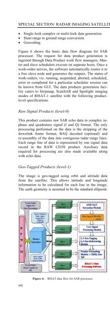
SPECIAL SECTION: RADAR IMAGING SATELLITE-1• Single-look complex or multi-look data generati<strong>on</strong>.• Slant range to ground range c<strong>on</strong>versi<strong>on</strong>.• Geocoding.Figure 6 shows the basic data flow diagram for SARprocessor. The request for data product generati<strong>on</strong> isingested through Data Product work flow managers. Masterand slave schedulers execute <strong>on</strong> separate hosts. Once awork-order arrives, the software automatically routes it toa free slave node and generates the outputs. The status ofwork-orders, viz. running, suspended, aborted, scheduled,error or completed for a particular scheduler sessi<strong>on</strong> canbe known from GUI. The data products generati<strong>on</strong> facilitycaters to Stripmap, ScanSAR and Spotlight imagingmodes of <strong>RISAT</strong>-1 satellite with the following productlevelspecificati<strong>on</strong>s.Raw Signal Products (level-0)This product c<strong>on</strong>tains raw SAR echo data in complex inphaseand quadrature signal (I and Q) format. The <strong>on</strong>lyprocessing performed <strong>on</strong> the data is the stripping of thedownlink frame format, BAQ decoded (opti<strong>on</strong>al) andre-assembly of the data into c<strong>on</strong>tiguous radar range lines.Each range line of data is represented by <strong>on</strong>e signal datarecord in the RAW CEOS product. Auxiliary datarequired for processing are also made available al<strong>on</strong>gwith echo data.Geo-Tagged Products (level-1)The image is geo-tagged using orbit and attitude datafrom the satellite. This allows latitude and l<strong>on</strong>gitudeinformati<strong>on</strong> to be calculated for each line in the image.The earth geometry is assumed to be the standard ellipsoid.Each image line c<strong>on</strong>tains auxiliary informati<strong>on</strong> whichincludes the latitude and l<strong>on</strong>gitude of the first, mid andlast pixels of the line. The raw radar signal data are processedto provide SAR image data pixels. The image pixeldata are represented by a series of CEOS processed datarecords, each record c<strong>on</strong>taining <strong>on</strong>e complete line ofpixels lying in the range dimensi<strong>on</strong> of the image. Theproduct can be obtained as slant range data (16 bit I and16 bit Q) or ground range (16 bit) amplitude data. Additi<strong>on</strong>ally,an auxiliary file c<strong>on</strong>taining a dense grid of geolocati<strong>on</strong>sis associated al<strong>on</strong>g with the data file.Terrain-corrected Geocoded Products (level-2)This product c<strong>on</strong>tains terrain-corrected and geocodeddata. Provisi<strong>on</strong>s exist for UTM (default for systematicpojecti<strong>on</strong>) and polyc<strong>on</strong>ic map projecti<strong>on</strong>. The pixel spacingin the product will depend <strong>on</strong> SAR operating mode,number of looks and look angle. The opti<strong>on</strong>s for productformats are CEOS and GEOTIFF.Figure 7 shows typical <strong>RISAT</strong>-I SAR data products forvarious SAR operating modes.Hardware quick look and near real-time SARprocessorsC<strong>on</strong>sidering the growing user demand and inevitable necessityof real or near-real time SAR DP, the design anddevelopment of a HWQLP/NRTP was pursued as <strong>on</strong>e ofthe missi<strong>on</strong> goals of <strong>RISAT</strong>-1 ground segment. TheHWQLP/NRTP has been built, to the extent possible,using <strong>on</strong>ly Commercial-Off-The-Shelf (COTS) DigitalSignal Processor (DSP) and other hardware plug-in modules<strong>on</strong> a Compact PCI (cPCI) platform. Thus, the majorthrust for the HWQLP has been <strong>on</strong> working out multi-DSP architecture and algorithm development and optimizati<strong>on</strong>.The HWQLP is currently installed at NRSCShadnagar, ground receive stati<strong>on</strong> with system c<strong>on</strong>figurati<strong>on</strong>as shown in Figure 5, and is mainly used for dataFigure 6. <strong>RISAT</strong> data flow for SAR processor.Figure 7.<strong>RISAT</strong>-I data products for various SAR modes of operati<strong>on</strong>.486CURRENT SCIENCE, VOL. 104, NO. 4, <strong>25</strong> FEBRUARY <strong>2013</strong>