1065 - OGP Surveying and Positioning Committee
1065 - OGP Surveying and Positioning Committee
1065 - OGP Surveying and Positioning Committee

You also want an ePaper? Increase the reach of your titles
YUMPU automatically turns print PDFs into web optimized ePapers that Google loves.
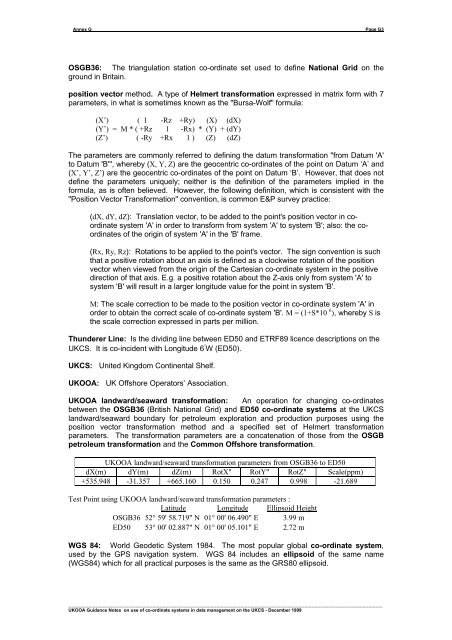
Annex G____________________________________________________________________________________________________________Page G3OSGB36: The triangulation station co-ordinate set used to define National Grid on theground in Britain.position vector method. A type of Helmert transformation expressed in matrix form with 7parameters, in what is sometimes known as the "Bursa-Wolf" formula:(X’) ( 1 -Rz +Ry) (X) (dX)(Y’) = M * ( +Rz 1 -Rx) * (Y) + (dY)(Z’) ( -Ry +Rx 1 ) (Z) (dZ)The parameters are commonly referred to defining the datum transformation "from Datum 'A'to Datum 'B'", whereby (X, Y, Z) are the geocentric co-ordinates of the point on Datum ‘A’ <strong>and</strong>(X’, Y’, Z’) are the geocentric co-ordinates of the point on Datum ‘B’. However, that does notdefine the parameters uniquely; neither is the definition of the parameters implied in theformula, as is often believed. However, the following definition, which is consistent with the"Position Vector Transformation" convention, is common E&P survey practice:(dX, dY, dZ): Translation vector, to be added to the point's position vector in coordinatesystem 'A' in order to transform from system 'A' to system 'B'; also: the coordinatesof the origin of system 'A' in the 'B' frame.(Rx, Ry, Rz): Rotations to be applied to the point's vector. The sign convention is suchthat a positive rotation about an axis is defined as a clockwise rotation of the positionvector when viewed from the origin of the Cartesian co-ordinate system in the positivedirection of that axis. E.g. a positive rotation about the Z-axis only from system 'A' tosystem 'B' will result in a larger longitude value for the point in system 'B'.M: The scale correction to be made to the position vector in co-ordinate system 'A' inorder to obtain the correct scale of co-ordinate system 'B'. M = (1+S*10 6 ), whereby S isthe scale correction expressed in parts per million.Thunderer Line: Is the dividing line between ED50 <strong>and</strong> ETRF89 licence descriptions on theUKCS. It is co-incident with Longitude 6 ° W (ED50).UKCS: United Kingdom Continental Shelf.UKOOA: UK Offshore Operators’ Association.UKOOA l<strong>and</strong>ward/seaward transformation: An operation for changing co-ordinatesbetween the OSGB36 (British National Grid) <strong>and</strong> ED50 co-ordinate systems at the UKCSl<strong>and</strong>ward/seaward boundary for petroleum exploration <strong>and</strong> production purposes using theposition vector transformation method <strong>and</strong> a specified set of Helmert transformationparameters. The transformation parameters are a concatenation of those from the OSGBpetroleum transformation <strong>and</strong> the Common Offshore transformation.UKOOA l<strong>and</strong>ward/seaward transformation parameters from OSGB36 to ED50dX(m) dY(m) dZ(m) RotX" RotY" RotZ" Scale(ppm)+535.948 -31.357 +665.160 0.150 0.247 0.998 -21.689Test Point using UKOOA l<strong>and</strong>ward/seaward transformation parameters :Latitude Longitude Ellipsoid HeightOSGB36 52° 59' 58.719" N 01° 00' 06.490" E 3.99 mED50 53° 00' 02.887" N 01° 00' 05.101" E 2.72 mWGS 84: World Geodetic System 1984. The most popular global co-ordinate system,used by the GPS navigation system. WGS 84 includes an ellipsoid of the same name(WGS84) which for all practical purposes is the same as the GRS80 ellipsoid._____________________________________________________________________________________________UKOOA Guidance Notes on use of co-ordinate systems in data management on the UKCS - December 1999