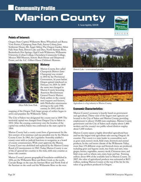
Community ProfileMarion CountyK. Susan Appleby, <strong>SEDCOR</strong>Points of Interest:Oregon State Capi<strong>to</strong>l, Willamette River, Wheatland and BuenaVista Ferries, Champoeg State Park, Aurora Colony, JesseSettlemier House, Mt. Angel Abbey, The Oregon Garden, SilverFalls State Park, Detroit Lake and Dam, North Santiam River,Breitenbush Hot Springs, Opal Creek Wilderness, WillametteUniversity, Corban College, Chemeketa Community College,Mission Mill Museum, his<strong>to</strong>ric Bush House and DeepwoodEstate, and the A.C. Gilbert House Children’s Museum.His<strong>to</strong>ry:Marion County, first calledChampoick District (laterChampoeg) was createdin 1843 by the ProvisionalGovernment, 16 years beforeOregon gained statehood onFebruary 14, 1859. In 1849the name was changed <strong>to</strong>Marion County honoringAmerican RevolutionaryGeneral Francis Marion.Early settlers <strong>to</strong> the countywere trappers and farmers,with Methodist missionariesSilver Falls State Park. arriving in the early 19thcentury. In 1843, with themapping of the Oregon Trail, larger groups of settlers began <strong>to</strong>arrive and populate the Willamette Valley.The City of Salem was designated the county seat in 1849. Theterri<strong>to</strong>rial capital was changed from Oregon City <strong>to</strong> Salem in1852. After the ensuing controversy over the location of thecapital was settled, Salem was confirmed as the state capital in1864.Marion County had a county court form of government for thefirst century of its existence and was presided over by the MarionCounty Court. In 1961, the Legislative Assembly enabled acounty court with no judicial functions <strong>to</strong> reorganize as a boardof county commissioners. With court approval, the MarionCounty Court was abolished and replaced by the Marion CountyBoard of Commissioners in 1963. Today, Marion County is oneof the 27 general law counties in the state, with nine counties ashome rule counties.Marion County’s present geographical boundaries established in1856, are the Willamette River and Butte Creek on the north,Cascade Range on the east, the Santiam River and North Fork ofthe Santiam on the south and the Willamette River on the west.Detroit Lake – a recreational paradise.Agriculture is a big industry in Marion County.Economic Characteristics:Marion County’s economy is heavily based on governmentand agriculture. Thirty-nine of the largest state agencies arelocated in the City of Salem and Marion County, providingemployment <strong>to</strong> almost 19,000 state employees. Marion Countygovernment and the City of Salem each employ about 1,400workers and the county’s ten public school districts employabout 5,400 workers.Marion County enjoys a highly diversified agricultural baseand has the largest <strong>to</strong>tal agriculture sales among Oregon’s 36counties. The county is a state leader in commodities suchas grass seed, nursery s<strong>to</strong>ck, field crops, lives<strong>to</strong>ck and animalproducts. In the cool moist climate of the Willamette Valley,more than 170 different crops and lives<strong>to</strong>ck items are produced,including grass and legume seeds, tree fruits and nuts, winegrapes, berries, vegetables, nursery s<strong>to</strong>ck, Christmas trees, andfield crops such as wheat, oats, mint, hops and hay. Farmingutilizes about 40% of the available land in Marion County. In2007, the value of agricultural products was estimated at $615million, ranking Marion County at the <strong>to</strong>p of the list for thevalue of ag-products produced in Oregon.Page 20<strong>SEDCOR</strong> Enterprise Magazine
Oregon 150SesquicentennialMarion County150 Miles for 150 YearsMarion County is pleased <strong>to</strong> join in withcommunities across the state and take part inhonoring Oregon’s 150th birthday. There willbe passports with his<strong>to</strong>ric clues for each of the20 cities, relays, geocaching, and plenty of eventsthroughout the year in all the communitiesaround the county.Sunflowers outside Silver<strong>to</strong>nPho<strong>to</strong> by Bill EnosMarion County Population GrowthPamela Ferrara, Workforce AnalystWorksource Oregon Employment DepartmentPamela.A.Ferrara@state.or.usMarion County’s population changes haveinfluenced the size and composition of itslabor force. Let’s take a look at some of thosechanges in the county over the decades.Marion County Oregon 150 Passport eventis providing a map of Marion County withsuggested destinations in each city. These siteshave his<strong>to</strong>ric value and are destinations withevents important <strong>to</strong> the community. The passportwill be available in locations throughout MarionCounty and will allow visi<strong>to</strong>rs <strong>to</strong> document theirvisits. The Marion County Commissioners plan <strong>to</strong>recognize those who visit the most destinations ata public celebration later this year.It is hoped that this passport will bring people<strong>to</strong> the communities <strong>to</strong> visit, promote economicdevelopment, as well as enhance <strong>to</strong>urism andawareness of each city and its special, his<strong>to</strong>ricalplaces <strong>to</strong> visit.The 150-mile route starts in Idanha and linkseach incorporated city before it ends in Salem.Participants may choose <strong>to</strong> start their <strong>to</strong>ur at anypoint on the map - and it can be done in oneday or several days as desired. This route offersvisi<strong>to</strong>rs a chance <strong>to</strong> learn about the his<strong>to</strong>ricalsignificance and contribution of the cities <strong>to</strong>Oregon’s statehood. The <strong>to</strong>ur through MarionCounty cities will foster a better understanding ofeach city’s contribution <strong>to</strong> the past and challengesfor the future.150 Miles for 150 Years RelayThe relay event will <strong>to</strong>ur each of Marion County’stwenty cities and many of the county’s thirtysevenunincorporated communities. There willbe festivities at each s<strong>to</strong>p along the relay. The150-mile relay will take place over five weekends,starting Saturday, June 13 and concluding onJuly 11. The 150-mile trek will begin at MarionCounty’s easternmost boundary near Idanha;continue through the Santiam Canyon <strong>to</strong> thecounty’s southern boundary at Jefferson; thentravel north through Salem <strong>to</strong> Keizer and St. Paul;then eastward <strong>to</strong> Aurora and south <strong>to</strong> Silver<strong>to</strong>n.The trek will end in Salem at the Oregon StateFairgrounds during the 2009 Marion CountyFair.For complete information visitGlockenspiel in Mount AngelA scenic Cascade Mountain viewQuick Facts:County Seat: SalemArea: 1,194 Square MilesEstablished: July 5, 1843Population (2008): 314,865Cities: 20 incorporated,37 unincorporatedElevation: 154 feet atSalem & 1,595 feet atDetroit LakePrincipal Industries:Agriculture, government,food processing, lumber,manufacturing, educationand <strong>to</strong>urismMarion County had 314,865 residents in2008, according <strong>to</strong> the Population ResearchCenter at Portland State University. Seventythree percent of the county’s population livedin 20 incorporated cities and <strong>to</strong>wns. Four ofthose have part of their population living inother counties (Idanha, Gates and Mill Cityare part in Linn County, and West Salem, ispart of Polk County). Nearly half the county’spopulation lives in the state’s capi<strong>to</strong>l, Salem– its population in 2008 was 154,510.His<strong>to</strong>rically Marion County’s populationgrowth has generally grown about in tandemwith the state’s population, but with larger andsmaller differences over the decades (Graph1). More recently, the county grew 12 percentfrom 1980 <strong>to</strong> 1990, and 25 percent from 1990<strong>to</strong> 2000. The states growth rates were8 percent and 20 percent respectively.From 2000 <strong>to</strong> 2008 the county’s populationgrew by 10 percent, about the same as the stateas a whole. Marion County will have slightlyslower population growth from 2010 <strong>to</strong> 2040than the state as a whole, according <strong>to</strong> thestate Department of Administrative Servicespopulation projections.The Hispanic population in the countyhas doubled each decade from 1980, andHispanics made up nearly 22 percent of theMarion county population in 2007. Thecounty had a higher percentage of residentsage 17 and under than the state as a whole.Eighty one percent of the population age 25and older had at least a high school diplomain 2007 compared <strong>to</strong> 87 percent for the state.Twenty one percent in Marion County had aleast a bachelor’s degree, compared <strong>to</strong> nearly28 percent in the state as a whole.www.sedcor.comPage 21