Muckanagh_mini_report_2009 - Inland Fisheries Ireland
Muckanagh_mini_report_2009 - Inland Fisheries Ireland
Muckanagh_mini_report_2009 - Inland Fisheries Ireland
- No tags were found...

Create successful ePaper yourself
Turn your PDF publications into a flip-book with our unique Google optimized e-Paper software.
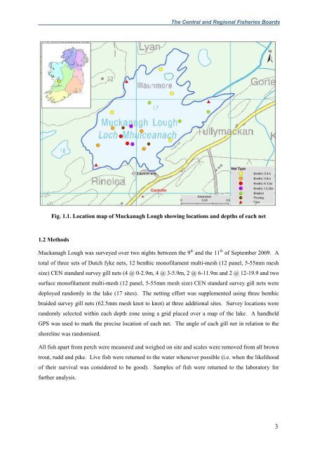
The Central and Regional <strong>Fisheries</strong> BoardsFig. 1.1. Location map of <strong>Muckanagh</strong> Lough showing locations and depths of each net1.2 Methods<strong>Muckanagh</strong> Lough was surveyed over two nights between the 9 th and the 11 th of September <strong>2009</strong>. Atotal of three sets of Dutch fyke nets, 12 benthic monofilament multi-mesh (12 panel, 5-55mm meshsize) CEN standard survey gill nets (4 @ 0-2.9m, 4 @ 3-5.9m, 2 @ 6-11.9m and 2 @ 12-19.9 and twosurface monofilament multi-mesh (12 panel, 5-55mm mesh size) CEN standard survey gill nets weredeployed randomly in the lake (17 sites). The netting effort was supplemented using three benthicbraided survey gill nets (62.5mm mesh knot to knot) at three additional sites. Survey locations wererandomly selected within each depth zone using a grid placed over a map of the lake. A handheldGPS was used to mark the precise location of each net. The angle of each gill net in relation to theshoreline was randomised.All fish apart from perch were measured and weighed on site and scales were removed from all browntrout, rudd and pike. Live fish were returned to the water whenever possible (i.e. when the likelihoodof their survival was considered to be good). Samples of fish were returned to the laboratory forfurther analysis.3