12 STEPS TO DRAFTING A BUILDING PLAT - News Room, DC
12 STEPS TO DRAFTING A BUILDING PLAT - News Room, DC
12 STEPS TO DRAFTING A BUILDING PLAT - News Room, DC
- No tags were found...

Create successful ePaper yourself
Turn your PDF publications into a flip-book with our unique Google optimized e-Paper software.
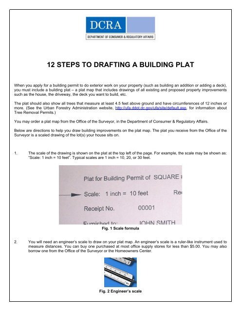
<strong>12</strong> <strong>STEPS</strong> <strong>TO</strong> <strong>DRAFTING</strong> A <strong>BUILDING</strong> <strong>PLAT</strong>When you apply for a building permit to do exterior work on your property (such as building an addition or adding a deck),you must include a building plat – a plat map that includes drawings of all existing and proposed property improvementssuch as the house, the driveway, the deck you want to build, etc.The plat should also show all trees that measure at least 4.5 feet above ground and have circumferences of <strong>12</strong> inches ormore. (See the Urban Forestry Administration website, http://ufa.ddot.dc.gov/ufa/site/default.asp, for information aboutTree Removal Permits.)You may order a plat map from the Office of the Surveyor, in the Department of Consumer & Regulatory Affairs.Below are directions to help you draw building improvements on the plat map. The plat you receive from the Office of theSurveyor is a scaled drawing of the lot(s) your house sits on.1. The scale of the drawing is shown on the plat at the top left of the page. For example, the scale may be shown as:“Scale: 1 inch = 10 feet”. Typical scales are 1 inch = 10, 20, or 30 feet.Fig. 1 Scale formula2. You will need an engineer’s scale to draw on your plat map. An engineer’s scale is a ruler-like instrument used tomeasure distances. You can buy one purchased at most office supply stores for less than $5.00. You may alsoborrow one from the Office of the Surveyor or the Homeowners Center.Fig. 2 Engineer’s scale
3. You may be able to get a copy of the dimensions of your existing property from:• Your Mortgage Survey – Most homebuyers receive mortgage surveys of their properties showing thehouse and improvements such as decks, sheds, and fences. These scaled drawings show thedimensions of the structures and the distances they are from your property line.• Office of the Surveyor – The Office of the Surveyor may have the dimensions of your house when itwas built, in Survey Jackets or Wall Reports that the builder filed.4. If the Office of the Surveyor doesn’t have your house’s dimensions and you have no survey of your property, youmay want to hire a private <strong>DC</strong> licensed surveyor. The licensed surveyor can give you professional, scaleddrawings of your house and its improvements.5. Once you have the correct dimensions of the structures on your property and their distances from the propertyline, you can draw the house and improvements on the plat map.6. To draw the house and improvements on the plat, first identify the scale of the drawing and rotate the engineer’sscale to the same scale. Each mark or tic on the scale would be equal to 1 foot.For example, if your survey shows that your house is 10 feet from the left property line, lay the engineer’s scalewith the 0 end on the front line of the plat and count 10 tics. Then place a small mark on the plat using a pencil.Fig. 3 Measuring 10 feet from property line7. If the survey shows your house is 8 feet from the front property line, place the scale along the side property lineand count back 8 tics.Fig. 4 Measuring 8 feet from property line
8. Using the scale as a straight edge, connect the dots with light pencil lines. This will show the left front corner ofyour house.Fig. 5 Drawing the left front corner of your house9. Based on the survey information, place the 0 end of the scale next to the mark you made. Measure along thepencil line the distance shown on the survey (for example, 20 feet). You now have the front line of your house.Fig. 6 Drawing the front of your house
10. From this line you can draw the rest of the house, using the distances shown on the survey.Fig. 7 Drawing the rest of your house11. Pencil the lines lightly first so that any mistakes can be easily erased. Darken with a pen after you’ve finished thedrawing. Show existing house lines as \\\\\\\\; new construction as solid lines; and fences as ----x----x---. Theexample below shows a new back yard fence and a new deck.Fig. 8 Completed plat map<strong>12</strong>. You need three copies of the completed plat map for most permits. You may want to draw on one plat and makecopies. (A copy machine in the Office of the Surveyor prints paper sizes up to 11” X 17” for $1.00 per copy.)Revised <strong>12</strong>-10-06