Student Materials - Mission Geography
Student Materials - Mission Geography
Student Materials - Mission Geography
- No tags were found...
You also want an ePaper? Increase the reach of your titles
YUMPU automatically turns print PDFs into web optimized ePapers that Google loves.
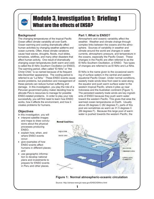
Module 3, Investigation 1: Briefing 1What are the effects of ENSO?BackgroundThe changing temperatures of the tropical PacificOcean affect climate variability all over Earth.Ocean warming and cooling dramatically affecthuman activities by changing weather patterns andocean currents. Often, these climate variationscause heat waves, droughts, floods, mud slides,tornadoes, wildfires, and many other disasters thataffect human activity. One result of dramaticallychanging ocean temperatures (both warm and cold)is called the El Niño Southern Oscillation (or ENSO).The warming period, often called “El Niño” or “theChrist Child,” is so named because of its frequentlate-December appearance. The cooling period isreferred to as “La Niña.” These ENSO events causesevere problems, but prediction and management ofthese periods can reduce human suffering anddamage. In this investigation, you play the role of aPeruvian government policy maker deciding how toallocate Peru’s resources to manage for possibleENSO-related problems. In order to play your rolesuccessfully, you will first need to learn how ENSOworks, how it affects the environment, and how itcreates problems for humans.ObjectivesIn this investigation, you will• interpret satellite imagesand maps to draw conclusionsabout the physicalprocesses producingENSO;• explain how, when, andwhere ENSO eventsoccur;• give examples of howENSO events affecthumans in different places;and• use geographic informationto develop nationalplans and investments toprepare for ENSO eventsin Peru and other places.Part 1. What is ENSO?Atmospheric and oceanic variability affect theweather. Weather and climate change throughcomplex links between the oceans and the atmosphere.Sources of variability in weather andclimate around the world are changes in watercurrents, atmospheric pressure, and temperature inthe oceans, especially the Pacific Ocean. Thesechanges in the Pacific are often referred to as theEl Niño Southern Oscillation, or ENSO. Two typesof changes are referred to as El Niño and La Niña.El Niño is the name given to the occasional warmingof surface waters in the central and easternequatorial Pacific Ocean. Under normal conditions,easterly trade winds blow from east to west alongthe equator and push warm surface water to thewestern tropical Pacific, where it piles up nearIndonesia and the Australian continent (Figure 1).The persistent easterly trade winds are key ingredientsof ENSO because they push warm watertoward the western Pacific. This gives that area thewarmest ocean temperatures on Earth. Usuallyabove 28 degrees C (82 degrees F), parts of thispool are sometimes as warm as 31.5 degrees C(89 degrees F). Because this large pool of warmwater is pushed towards the western Pacific, theFigure 1: Normal atmospheric-oceanic circulationSource: http://airsea-www.jpl.nasa.gov/ENSO/ElNino.html18
Module 3, Investigation 1: Briefing 1What are the effects of ENSO?atmosphere above the oceanis heated, causing favorableconditions for convection andprecipitation. In fact, thepersistent oceanic heatsurrounding Indonesia andother western Pacific islandsleads to frequent thunderstormsand some of theheaviest rainfall on Earth.As the easterly trade windspush warm surface wateragainst the western boundaryof the Pacific Ocean, colder,nutrient-rich water comes upfrom below along the coast ofSouth America to replace it.This is called upwelling.Upwelling helps fish andother animals thrive. Inaddition, as the warm surface water moves westward,the layer dividing the warm surface waterand deep cold water, known as the thermocline, israised. Because warm water contains morevolume than colder water, and because trade windspush the water westward, the sea level is higher onthe western side of the Pacific. In fact, the sealevel in the Philippines is normally about 60 centimeters(23 inches) higher than the sea level on thesouthern coast of Panama.In the upper levels of the atmosphere, the windsblow from west to east, completing a large-scaleatmospheric circulation known as the WalkerCirculation, named after Sir Gilbert Walker whostudied variations in the tropical Pacific atmosphereduring the 1920s.In an El Niño year (Figure 2), which typically occursevery three to seven years, the normal trade windsdiminish and the warm pool of water in the westernPacific is free to move back along the equatortoward the east and the South American continent.The sea level drops in the west and rises in theeast as warm surface water surges along theequator in the form of a pulse, or a Kelvin Wave. Inaddition, the upwelling of cold water along theSouth American coast decreases, reducing thesupply of nutrients to fish and other animals.Figure 2: El Niño circulationSource: http://airsea-www.jpl.nasa.gov/ENSO/ElNino.html29This displacement of the warm water affects theatmosphere. The convection and precipitation thatpreviously occurred in the western Pacific shifts withthe warm pool to the central and eastern Pacific andusually results in heavier than normal rains overareas such as northern Peru, Ecuador, and otherareas in tropical South America. In the westernPacific, the mechanism for precipitation is shut off,and Indonesia and Australia will often experiencedrought conditions while an El Niño persists.In a La Niña year, unusually cold ocean temperaturesoccur in the equatorial Pacific, which is theopposite of an El Niño. Generally, during a LaNiña, the easterly trade winds increase in intensity,more upwelling occurs, and the water temperaturesalong the equator are reduced. This usually resultsin less cloudiness and rainfall for South Americaand more rainfall over Indonesia, Malaysia, andnorthern Australia.Throughout this investigation, you should answerthe questions on the Log at the end of this briefing.Here are the first three questions:1. Why are easterly trade winds key ingredients inENSO?2. What is the thermocline?3. What are the indicators of a La Niña?
Module 3, Investigation 1: Briefing 1What are the effects of ENSO?Part 2. How is ENSO measured?In order to both understand how ENSO works morefully and predict its effects, better measurements ofocean conditions and climate change are needed.Scientists have begun a number of different measurementprojects to identify El Niño and La Niña.For example, space-borne sensors are helping tomonitor variations of surface wind, sea level, andsea surface temperature along the equator and thewest coasts of the American continents.Sea level measurements. NASA satellites canmeasure sea level for the entire Pacific Ocean within5 centimeters (2 inches) (Figure 3). Images fromthese satellites can tell us where the warm water islocated in the Pacific Ocean because it takes upmore volume, thus raising the level of the ocean.Upwelling measurements. Another way ofmeasuring ENSO using satellites is by examiningupwelling. Upwelling currents carry nutrients withthem, which leads to phytoplankton growth andchlorophyll blooms. Satellites can detect thepigments of the phytoplankton from space. Figure4 illustrates what satellite images ofphytoplankton look like.Figure 3: Topex-Poseiden satelliteSource: http://topex-www.jpl.nasa.gov/discover/image-gallery/gifs/tp-jpl-oh99-disp1.jpgFigure 4: Upwelling alongSouth American coastSources: http://seawifs.gsfc.nasa.gov/SEAWIFS.htmlhttp://seawifs.gsfc.nasa.gov/SEAWIFS/CZCS_DATA/south_america.html310
Module 3, Investigation 1: Briefing 1What are the effects of ENSO?Ocean-based measurements.Anothermethod of identifyingwhen an ENSO eventis starting is throughmeasurements takenin the water of thePacific Ocean.Scientists havecreated an extensivesystem of floating andmoored buoys, tidegage stations, andship-based observationsystems throughoutthe Pacific Ocean(Figure 5).Answer Question 4 onthe Log.Figure 5: Ocean monitoring systemSource: http://www.pmel.noaa.gov/toga-tao/pmel-graphics/gif/enso-obs-sys.gifPart 3. How do El Niño and La Niñaaffect the weather?The large oceanic and atmospheric changescaused by El Niño and La Niña have a profoundeffect on Earth’s weather. This is because ENSOoccurrences have strong teleconnections to otherweather patterns. Teleconnections are atmosphericinteractions between widely separatedregions. One way of thinking of teleconnections isthat changes in the ocean and atmosphere in thePacific can have a ripple effect on climatic conditionsin other parts of Earth. This worldwide messageis conveyed by shifts in tropical rainfall andwind patterns over much of the globe. Imagine arushing stream flowing over and around a series oflarge boulders. The boulders create a train ofwaves that extend downstream, with crests andtroughs that show up in fixed positions. If one of theboulders were to shift, the shape of the wave trainwould also change and the crests and troughswould occur in different places.Scientists are studying the relationships betweenENSO events and weather around the globe todetermine whether links exist. Understanding theseteleconnections can help in forecasting droughts,floods, tropical storms, and hurricanes. Based onENSO patterns and on measurements of thegeneral circulation of the atmosphere and oceans,scientists are predicting abnormally wet, dry, warm,or cold conditions for different regions at differenttimes. Figures 6 and 7 illustrate the global weatherpatterns during an El Niño and a La Niña.Answer Question 5 on the Log.411
Module 3, Investigation 1: Briefing 1What are the effects of ENSO?EL NIÑO RELATIONSHIPSDECEMBER - FEBRUARYFigure 6: El Niño global weather effectsSource: http://www.cpc.ncep.noaa.gov/products/analysis_monitoring/impacts/warm.gifLA NIÑA RELATIONSHIPSDECEMBER - FEBRUARYFigure 7: La Niña global weather effectsSource: http://www.cpc.ncep.noaa.gov/products/analysis_monitoring/impacts/cold.gif512
Module 3, Investigation 1: Briefing 1What are the effects of ENSO?Figure 8: Temperature changeduring El Niño in the UnitedStatesSource: http://nsipp.gsfc.nasa.gov/enso/primer/englishprimer5.htmlFigure 9: El Niño precipitationin the United StatesSource: http://nsipp.gsfc.nasa.gov/enso/primer/englishprimer6.htmlHow does ENSO affect weather patterns in NorthAmerica? During an El Niño, there is a tendencyfor higher than normal temperatures in westernCanada and the upper plains of the United States.This is because the low-pressure system in thePacific draws up warm air into Canada, some ofwhich filters into the northern United States (Figure8). Another low-pressure system draws cold moistair into the southern United States, bringing lowerthan normal temperatures.The same low-pressure system in the southernUnited States is also responsible for increases inprecipitation during an El Niño, especially in thoseareas close to the Gulf of Mexico (Figure 9).Answer Question 6 on the Log.613
Module 3, Investigation 1: Briefing 1What are the effects of ENSO?Part 4. How are human activities affectedby ENSO?ENSO has many effects on human activities. Theeconomic impacts of the 1982-1983 El Niño,perhaps the strongest event in recorded history,are conservatively estimated to have exceeded$8 billion worldwide from droughts, fires, flooding,and hurricanes (Table 1). Virtually every continentwas affected by this strong event. An estimated1,000 to 2,000 deaths were blamed on El Niño andthe disasters that accompanied it. In addition, theextreme drought in the Midwest Corn Belt of theUnited States during 1988 has been tentativelylinked to the “cold event,” or La Niña, of 1988 thatfollowed the ENSO event of 1986-1987.The effects of El Niño and La Niña vary according tothe strength of the episodes and the geographicdistribution of weather changes. Some areasexperience heat waves and droughts, while othershave torrential rains and flooding. These specificweather events occur within wet, dry, warm, andcool zones associated with the episodes (Figure 10).Table 1: The costs of the 1982-83 ElNiñoEvent/RegionFloodingBoliviaEquador,Northern PeruCubaU.S. Gulf StatesHurricanesTahitiHawaiiDrought/FiresSouthern AfricaSouthern India,Sri LankaPhilippinesIndonesiaAustraliaSouthern Peru,Western BoliviaMexico, CentralAmericaCost$ 300,000,000650,000,000170,000,0001,270,000,000$ 50,000.000230,000,000$1,000,000,000150,000,000450,000.000500,000,0002,500,000,000240,000,000600,000,000Total$8,110,000,000Generalized Effects of El NiñoSource: http://nsipp.gsfc.nasa.gov/enso/primerFigure 10: Generalized effects of El NiñoSource: http://globe.gsfc.nasa.gov/cgi-bin/show.cgi?l=en&b=g&rg=n&page=gallery-elnino-background.ht714
Module 3, Investigation 1: Log 1What are the effects of ENSO?1. Why are the easterly trade winds key ingredients in ENSO?2. What is the thermocline?3. What are the indicators of a La Niña?4. Why do you think ocean-based measurements are important?5. Describe the different effects of El Niño and La Niña on each of the following regions:North AmericaSouth AmericaAfricaAsiaSoutheast Asia6. What are the El Niño temperature and precipitation predictions for your hometown?815
Module 3, Investigation 1: Briefing 2The ENSO game: Predicting and managing for El Niño and La NiñaPart 5. The ENSO gameHow can prediction help avoid ENSO’s tragichuman consequences? Scientists from around theworld are involved in forecasting, with computermodels and sophisticated measurements, howENSO affects various countries. These scientistsare increasingly being asked by policy makers andpolitical leaders to help them plan and manage forthe effects of ENSO. In the ENSO game, you playthe role of a policy maker in Peru. You mustdetermine, based on information given to you byclimate specialists, what sort of ENSO variation isoccurring. Then you must decide how to allocatePeru’s resources to manage for possible weatherrelatedproblems.Background for the ENSO gameLong ago, Peruvians observed that the usually coolwater along the Pacific coast of their country becamewarmer in some years. Because this happenedaround Christmas time, they called it El Niño,which means “Christ Child.” Frequently, thesewarming spells were associated with increasedrainfall and flooding within the country. Many timesthe flooding was disastrous. In fact, El Niño-relatedweather disasters in 1997-1998 led to massiveflooding in the region, causing large negativeeconomic effects and the loss of human life.Peru provides a prime example of how even shorttermEl Niño forecasts can be valuable. There, asin most developing countries in the tropics, theeconomy (and food production in particular) ishighly sensitive to climate fluctuations. Warm (ElNiño) years tend to be unfavorable for fishing, andsome of them have been marked by damagingfloods along the coastal plain and in the westernAndean foothills in the northern part of the country.Cold years are welcomed by fishermen, but not byfarmers, because these years have frequently beenmarked by drought and crop failures. Peruvianshave reason to be concerned, not only about ElNiño events, but about both extremes of the ElNiño cycle.Peruvian planners have three primary concerns:agriculture, fishing, and disaster preparedness.Agriculture—Since 1983, forecasts of the upcomingrainy season have been issued each Novemberbased on observations of water temperatures and916upwelling in the tropical Pacific region. Once theforecast is issued, policy makers meet to decide onthe best combination of crops to plant in order toget the best overall yield. Rice and cotton, two ofthe primary crops grown in northern Peru, arehighly sensitive to the quantities and timing ofrainfall. Rice thrives on wet conditions during thegrowing season. Cotton, with its deeper rootsystem, can tolerate drier weather but cannottolerate wet weather during the harvest season.Hence, a forecast of El Niño weather might inducefarmers to plant more rice and less cotton than in ayear without El Niño.Fishing—Policy makers and fishermen also meetto decide how to manage for El Niño’s effects onthe fishing industry. El Niño is usually detrimentalto Peru’s coastal fisheries. Declines in coastalupwelling reduce the fish population. In addition,coastal flooding increases the amount of sedimentin the water so that the fish either leave or die fromunendurable water conditions. During El Niñoyears, the Peruvian fishing industry either reducesfishing or moves its fleets to the north or south tocatch migrating fish as upwelling patterns shiftaway from the Peruvian coast.Disaster preparedness—Policy makers meet withdisaster preparedness teams to determine whatweather-related problems associated with El Niñomay occur. Usually, El Niño periods lead to intenserainfall and disastrous flooding and destruction ofcritical property such as roads, bridges, dams, andpower lines—things referred to as infrastructure.Disaster teams need to prepare the country for thiseventuality or the effects of flooding will createserious economic and social problems.Data for the ENSO gameClimate specialists have submitted three keypieces of data to you in your role as a Peruvianplanner and policy maker (Figures 11, 12, and 13).By interpreting these data correctly, you candetermine whether an El Niño or a La Niña event isdeveloping off the coast of Peru.Is an El Niño or a La Niña forming? Support youranswer by referring to Figures 11, 12, and 13.Write your answer to this question on the ENSOGame Log.
Module 3, Investigation 1: Briefing 2The ENSO game: Predicting and managing for El Niño and La NiñaDegrees above averageFigure 11: Average sea surface temperature anomalies (degrees above or belownormal), measured in CelsiusSource: European Centre for Medium-Range Weather Forecasts (ECMWF) http://www.ecmwf.int/services/seasonal/forecast/index.jsp1017
Module 3, Investigation 1: Briefing 2The ENSO game: Predicting and managing for El Niño and La NiñaPercentAboveNormalFigure 12: Precipitation forecast (percent above normal)Source: International Research Institute for Climate Prediction (NOAA), http://iri.ldeo.columbia.edu/climate/forecasts/net_asmt/Previous YearThis YearFigure 13: Upwellinghttp://seawifs.gsfc.nasa.gov/SEAWIFS.html1118
Module 3, Investigation 1: Briefing 2The ENSO game: Predicting and managing for El Niño and La NiñaInvestments for the ENSO GameNow that you have determined whether an El Niñoor a La Niña is occurring, you need to decide how toallocate the resources you have, based on what islikely to happen. You will consider the effects of thisevent on agricultural productivity, the fishing industry,and weather-related damage to infrastructure.The World Bank is lending Peru $200 million toinvest in development efforts this year. The loanwill fund efforts to improve agricultural productivity,the fishing industry, and infrastructure (floodmanagement, highways, bridge supports, first aid,etc.). Based on the likelihood of an El Niño or a LaNiña event, your investments will either contributeto the future prosperity of the country or result indisaster and economic decline. You have threecategories to invest in, which are:Agricultural InvestmentsA. Rice productionB. Cotton productionFishing Industry InvestmentsA. More fishing boats and fishing productionB. Move the fleet north and south for the seasonC. No investments in fishing this yearDisaster Preparedness InvestmentsA. Invest in disaster preparednessB. No investmentsTo check on specific effects of El Niño, you canuse the following Internet resources:IndonesiaResources at this site include forest fires,drought, and warm temperatureshttp://www.ogp.noaa.gov/enso/asia.html#FiresSouthern AfricaResources at these sites include famine anddrought linkshttp://www.ogp.noaa.gov/enso/africa.htmlhttp://enso.unl.edu/ndmc/enigma/elnino.htmhttp://www.info.usaid.gov/fews/imagery/sat_nino.html#El NinoSoutheastern United StatesResources at these sites include flooding,cooler temperatures, and possible links totornadoeshttp://www.ogp.noaa.gov/enso/regional.html#Southeasthttp://www.srh.noaa.gov/ftproot/sjt/HTML/science/elninosjt.htmlCaliforniahttp://twister.sfsu.edu/elnino/elnino.htmlYou should allocate a total of $200 million on anycombination of investments, based on your determinationof whether the upcoming year will have anEl Niño or a La Niña. Investments should berounded up or down to the nearest $10 million.Use the table on The ENSO Game Log to make yourinvestments and then give your reasons for them.1219
Module 3, Investigation 1: Log 2The ENSO game: Predicting and managing for El Niño and La Niña1. Is an El Niño or a La Niña forming? Support your answer by referring to Figures 11, 12, and 13.2. Use this table to allocate a total of $200 million on any combination of investments. Make investmentsin increments of $10 million.Investment CategoryAgricultureRiceCottonAmount$ millionsMultiplierOutcome$ millionsFishingMore boats/productionMove fleet north and southNo investmentDisaster PreparednessInvestNo investmentTotals 2003. Give your reasons for your investment decisions in the spaces provided below.• Agricultural production• Fishing industry• Disaster preparedness infrastructure1320


