

View Chart Catalogue - Indian Naval Hydrographic Department
View Chart Catalogue - Indian Naval Hydrographic Department
View Chart Catalogue - Indian Naval Hydrographic Department
- No tags were found...

Create successful ePaper yourself
Turn your PDF publications into a flip-book with our unique Google optimized e-Paper software.
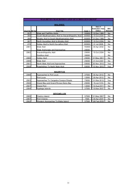
MALDIVES MAURITIUS AND SEYCHELLES GROUPMALDIVES<strong>Chart</strong> No. INT No. <strong>Chart</strong> Title Scale 1:Date ofPublication / NewEditionENCReleased227 Male and Fadiffolu Atolls 150000 15 Dec 1980 No265 South Maalhosmadulu Atoll to Ihavandhippolhu Atoll 300000 15 Oct 2004 No266 Mulaku Atoll to South Maalhosmadulu Atoll 300000 31 Dec 1996 No267 North Huvadhoo Atoll to Mulaku Atoll 300000 15 Oct 2004 No270 Addoo Atoll to North Huv adhoo Atoll 300000 31 Jul 2005 No2061 Male Atoll 150000 30 Apr 2002 NoMale Anchorage and Approaches 25000 No2062 Ihavandhippolhu Atoll 25000 15 Oct 2004 NoGoidhoo Atoll 30000 No2066 Addoo Atoll 25000 31 May 2001 No2099 Male Atoll 25000 31 Oct 2007 No2501 North Male Atoll and Approaches 50000 30 Nov 2012 Yes2508 Kaashidhoo To North Male Atoll 50000 15 Nov 2012 YesMAURITIUS2086 Approaches to Port Louis 37500 30 Apr 2012 NoPort Louis 12500 30 Apr 2012 No2503 Approaches To Cargados Carajos Shoals 75000 31 Mar 2012 Yes2506 Grand Bay and Grand Riviere Noire Bay 25000 15-Jul-1010 No2507 Grand Port 12500 14 Aug 2011 No2084 Agalega Islands 37500 15 Mar 2007 NoSEYCHELLES2085 Coetivy Island 37500 31 May 2007 No2087 Port Victoria 7500 30 Apr 2007 No2502 Western Approaches To Mahe Island 37500 28 Feb 2009 No14


