

View Chart Catalogue - Indian Naval Hydrographic Department
View Chart Catalogue - Indian Naval Hydrographic Department
View Chart Catalogue - Indian Naval Hydrographic Department
- No tags were found...

You also want an ePaper? Increase the reach of your titles
YUMPU automatically turns print PDFs into web optimized ePapers that Google loves.
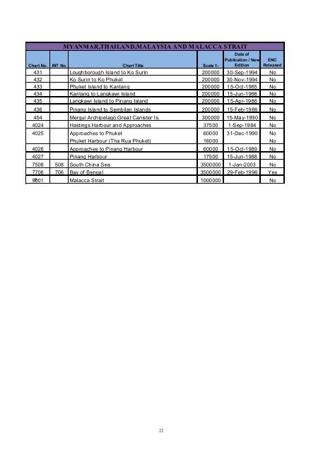
MYANMAR,THAILAND,MALAYSIA AND MALACCA STRAIT<strong>Chart</strong> No. INT No. <strong>Chart</strong> Title Scale 1:Date ofPublication / NewEditionENCReleased431 Loughborough Island to Ko Surin 200000 30-Sep-1994 No432 Ko Surin to Ko Phuket 200000 30-Nov-1994 No433 Phuket Island to Kantang 200000 15-Oct-1985 No434 Kantang to Langkawi Island 200000 15-Jun-1986 No435 Langkawi Island to Pinang Island 200000 15-Apr-1986 No436 Pinang Island to Sembilan Islands 200000 15-Feb-1986 No454 Mergui Archipelago;Great Canister Is. 300000 15-May-1990 No4024 Hastings Harbour and Approaches 37500 1-Sep-1984 No4025 Approaches to Phuket 60000 31-Dec-1990 NoPhuket Harbour (Tha Rua Phuket) 16000 No4026 Approaches to Pinang Harbour 60000 15-Oct-1989 No4027 Pinang Harbour 17500 15-Jun-1988 No7508 508 South China Sea 3500000 1-Jan-2003 No7706 706 Bay of Bengal 3500000 29-Feb-1996 Yes9001 ? Malacca Strait 1000000No22


