Tullos Hill - A Guide - Aberdeen City Council
Tullos Hill - A Guide - Aberdeen City Council
Tullos Hill - A Guide - Aberdeen City Council
- No tags were found...
Create successful ePaper yourself
Turn your PDF publications into a flip-book with our unique Google optimized e-Paper software.
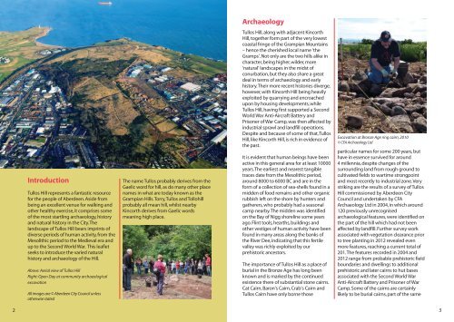
ArchaeologyIntroduction<strong>Tullos</strong> <strong>Hill</strong> represents a fantastic resourcefor the people of <strong>Aberdeen</strong>. Aside frombeing an excellent venue for walking andother healthy exercise, it comprises someof the most startling archaeology, historyand natural history in the <strong>City</strong>. Thelandscape of <strong>Tullos</strong> <strong>Hill</strong> bears imprints ofdiverse periods of human activity, from theMesolithic period to the Medieval era andup to the Second World War. This leafletseeks to introduce the varied naturalhistory and archaeology of the <strong>Hill</strong>.Above: Aerial view of <strong>Tullos</strong> <strong>Hill</strong>Right: Open Day at community archaeologicalexcavationAll images are © <strong>Aberdeen</strong> <strong>City</strong> <strong>Council</strong> unlessotherwise statedThe name <strong>Tullos</strong> probably derives from theGaelic word for hill, as do many other placenames in what are today known as theGrampian <strong>Hill</strong>s. Torry, <strong>Tullos</strong> and Tollohillprobably all mean hill, whilst nearbyKincorth derives from Gaelic wordsmeaning high place.<strong>Tullos</strong> <strong>Hill</strong>, along with adjacent Kincorth<strong>Hill</strong>, together form part of the very lowestcoastal fringe of the Grampian Mountains– hence the cherished local name ‘theGramps’. Not only are the two hills alike incharacter, being higher, wilder, more‘natural’ landscapes in the midst ofconurbation, but they also share a greatdeal in terms of archaeology and earlyhistory. Their more recent histories diverge,however, with Kincorth <strong>Hill</strong> being heavilyexploited by quarrying and encroachedupon by housing developments, while<strong>Tullos</strong> <strong>Hill</strong>, having first supported a SecondWorld War Anti-Aircraft Battery andPrisoner of War Camp, was then affected byindustrial sprawl and landfill operations.Despite and because of some of that, <strong>Tullos</strong><strong>Hill</strong>, like Kincorth <strong>Hill</strong>, is rich in evidence ofthe past.It is evident that human beings have beenactive in this general area for at least 10000years. The earliest and nearest tangibletraces date from the Mesolithic period,around 8000 to 6000 BC and are in theform of a collection of sea-shells found in amidden of food remains and other organicrubbish left on the shore by hunters andgatherers, who probably had a seasonalcamp nearby. The midden was identifiedon the Bay of Nigg shoreline some yearsago. Flint tools, hearths, buildings andother vestiges of human activity have beenfound in many areas along the banks ofthe River Dee, indicating that this fertilevalley was richly exploited by ourprehistoric ancestors.The importance of <strong>Tullos</strong> <strong>Hill</strong> as a place ofburial in the Bronze Age has long beenknown and is marked by the continuedexistence there of substantial stone cairns.Cat Cairn, Baron’s Cairn, Crab’s Cairn and<strong>Tullos</strong> Cairn have only borne thoseExcavation at Bronze Age ring cairn, 2010© CFA Archaeology Ltdparticular names for some 200 years, buthave in essence survived for around4 millennia, despite changes of thesurrounding land from rough ground tocultivated fields to wartime strongpointand most recently to industrial zone. Verystriking are the results of a survey of <strong>Tullos</strong><strong>Hill</strong> commissioned by <strong>Aberdeen</strong> <strong>City</strong><strong>Council</strong> and undertaken by CFAArchaeology Ltd in 2004, in which around120 previously unrecognisedarchaeological features, were identified onthe part of the hill which had not beenaffected by landfill. Further survey workassociated with vegetation clearance priorto tree planting in 2012 revealed evenmore features, reaching a current total of201. The features recorded in 2004 and2012 range from probable prehistoric fieldboundaries and dwellings to additionalprehistoric and later cairns to hut basesassociated with the Second World WarAnti-Aircraft Battery and Prisoner of WarCamp. Some of the cairns are certainlylikely to be burial cairns, part of the same23


