Tullos Hill - A Guide - Aberdeen City Council
Tullos Hill - A Guide - Aberdeen City Council
Tullos Hill - A Guide - Aberdeen City Council
- No tags were found...

You also want an ePaper? Increase the reach of your titles
YUMPU automatically turns print PDFs into web optimized ePapers that Google loves.
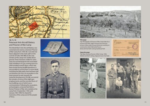
At any rate it was clear that this system wasuntenable and could not continueindefinitely. Ultimately an Act of Parliamentwas necessary to solve the conundrum. Bythe terms of the Act the proprietors couldappeal to a third party who, by arbitrationand independent consultation, wouldmore logically divide the lands. Thisresulted in a number of highly detailedplans and maps of the area being drawnup. One of the best of those is stillpreserved in the <strong>City</strong> Archives and is byGeorge Brown, dated 1777. It is thoroughlyinvaluable for any history of the area whichmight be undertaken. Then in 1785, afterdue deliberation, the lands were divided.The town got all the lands to the east withMenzies getting what was on the west.In 1786 the town council feued out theirshare of these lands in nine lots. Three ofthese feus were secured by David Morrice,an advocate in <strong>Aberdeen</strong>. Two plots werecalled Middleton and Altens and the lastbeing <strong>Tullos</strong>. In total Morrice paid a feuSurvey of area by George Brown, 1777duty of £42 8s and 46 bolls of oatmeal forall three plots. This feu contained what wasestimated to be only 100 acres of arableland compared to some 250 acres of hilland moor land, which in itself bears out thesuggestions that the land was largelyuninhabitable in the Medieval period.Morrice was, however, a seminal figure inthe development of <strong>Tullos</strong> <strong>Hill</strong> as we see ittoday. He planted trees and employedmodern farming techniques to createfarmed fields on the <strong>Hill</strong>. The consumptiondykes relate to this process whilst thedescendants of his trees are still to be seentoday. Whilst there had been a modestamount of farming on the hill in Medievaltimes, the agricultural revolution allowedmore land to be cultivated and so farmingbegan on a wider scale on the <strong>Hill</strong>.Peterseat and Ness Farms, which survivedinto the 20th century, owe their origins tothis process.Above: Detail of <strong>Tullos</strong> <strong>Hill</strong> fromGeorge Brown’s Survey of 1777Right: Ness Farm prior to demolition,courtesy of Ethel StewartThe 20th century broughtfurther considerable changesto <strong>Tullos</strong> <strong>Hill</strong>. An industrialestate on the seaward side ofthe <strong>Hill</strong> was developed in thelast decades of the 20thcentury whilst earlier on theSecond World War hadchanged the landscape of the<strong>Hill</strong>. Some of the land of one ofthe 19th century farms,Peterseat, was adapted tobecome an Anti-AircraftBattery, and subsequently aPrisoner of War Camp. In themiddle decades of the 20thcentury the <strong>Hill</strong> became hometo a landfill site.67