Tullos Hill - A Guide - Aberdeen City Council
Tullos Hill - A Guide - Aberdeen City Council
Tullos Hill - A Guide - Aberdeen City Council
- No tags were found...

Create successful ePaper yourself
Turn your PDF publications into a flip-book with our unique Google optimized e-Paper software.
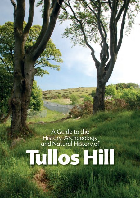
A <strong>Guide</strong> to theHistory, Archaeologyand Natural History of<strong>Tullos</strong> <strong>Hill</strong>
ArchaeologyIntroduction<strong>Tullos</strong> <strong>Hill</strong> represents a fantastic resourcefor the people of <strong>Aberdeen</strong>. Aside frombeing an excellent venue for walking andother healthy exercise, it comprises someof the most startling archaeology, historyand natural history in the <strong>City</strong>. Thelandscape of <strong>Tullos</strong> <strong>Hill</strong> bears imprints ofdiverse periods of human activity, from theMesolithic period to the Medieval era andup to the Second World War. This leafletseeks to introduce the varied naturalhistory and archaeology of the <strong>Hill</strong>.Above: Aerial view of <strong>Tullos</strong> <strong>Hill</strong>Right: Open Day at community archaeologicalexcavationAll images are © <strong>Aberdeen</strong> <strong>City</strong> <strong>Council</strong> unlessotherwise statedThe name <strong>Tullos</strong> probably derives from theGaelic word for hill, as do many other placenames in what are today known as theGrampian <strong>Hill</strong>s. Torry, <strong>Tullos</strong> and Tollohillprobably all mean hill, whilst nearbyKincorth derives from Gaelic wordsmeaning high place.<strong>Tullos</strong> <strong>Hill</strong>, along with adjacent Kincorth<strong>Hill</strong>, together form part of the very lowestcoastal fringe of the Grampian Mountains– hence the cherished local name ‘theGramps’. Not only are the two hills alike incharacter, being higher, wilder, more‘natural’ landscapes in the midst ofconurbation, but they also share a greatdeal in terms of archaeology and earlyhistory. Their more recent histories diverge,however, with Kincorth <strong>Hill</strong> being heavilyexploited by quarrying and encroachedupon by housing developments, while<strong>Tullos</strong> <strong>Hill</strong>, having first supported a SecondWorld War Anti-Aircraft Battery andPrisoner of War Camp, was then affected byindustrial sprawl and landfill operations.Despite and because of some of that, <strong>Tullos</strong><strong>Hill</strong>, like Kincorth <strong>Hill</strong>, is rich in evidence ofthe past.It is evident that human beings have beenactive in this general area for at least 10000years. The earliest and nearest tangibletraces date from the Mesolithic period,around 8000 to 6000 BC and are in theform of a collection of sea-shells found in amidden of food remains and other organicrubbish left on the shore by hunters andgatherers, who probably had a seasonalcamp nearby. The midden was identifiedon the Bay of Nigg shoreline some yearsago. Flint tools, hearths, buildings andother vestiges of human activity have beenfound in many areas along the banks ofthe River Dee, indicating that this fertilevalley was richly exploited by ourprehistoric ancestors.The importance of <strong>Tullos</strong> <strong>Hill</strong> as a place ofburial in the Bronze Age has long beenknown and is marked by the continuedexistence there of substantial stone cairns.Cat Cairn, Baron’s Cairn, Crab’s Cairn and<strong>Tullos</strong> Cairn have only borne thoseExcavation at Bronze Age ring cairn, 2010© CFA Archaeology Ltdparticular names for some 200 years, buthave in essence survived for around4 millennia, despite changes of thesurrounding land from rough ground tocultivated fields to wartime strongpointand most recently to industrial zone. Verystriking are the results of a survey of <strong>Tullos</strong><strong>Hill</strong> commissioned by <strong>Aberdeen</strong> <strong>City</strong><strong>Council</strong> and undertaken by CFAArchaeology Ltd in 2004, in which around120 previously unrecognisedarchaeological features, were identified onthe part of the hill which had not beenaffected by landfill. Further survey workassociated with vegetation clearance priorto tree planting in 2012 revealed evenmore features, reaching a current total of201. The features recorded in 2004 and2012 range from probable prehistoric fieldboundaries and dwellings to additionalprehistoric and later cairns to hut basesassociated with the Second World WarAnti-Aircraft Battery and Prisoner of WarCamp. Some of the cairns are certainlylikely to be burial cairns, part of the same23
Above: Excavation of gun emplacement site Below: Aerial photograph of gun emplacements from south, 1946Bronze Age cemeteryas the more wellknowncairnsmentioned above,while others relate toclearance of groundfor cultivation inprehistoric or laterperiods.Two short seasons ofexcavation directedby CFA Archaeology,in 2010 and 2012,and involving largenumbers of localvolunteers, focusedon two of therecently discoveredfeatures, both ofwhich were found to be of prehistoric,probably Bronze Age date. One was a hutcircle, the foundation of a substantial stoneand wooden building or roundhouse inwhich the first residents of <strong>Tullos</strong> <strong>Hill</strong> wouldhave lived while farming the surroundingland. The other was afurther burial cairn,which may havecontained crematedbone from a funeralpyre at that spot.At present there islittle evidence ofhuman activity inthe area underdiscussion betweenlater prehistory andthe 12th century AD.There is oneexception in theform of part of asolid silver chain,often described as‘Pictish’ and datingfrom about the 7th century, which wasfound in the 18th century by a farmer inthe nearby Bay of Nigg. Containing 95%silver this was obviously a high statusobject and hints at a continuity of humanactivity in the wider area.HistoryThe historical evidence for <strong>Tullos</strong> <strong>Hill</strong>begins in the later 12th century. In theclosing years of that century the church inthe Bay of Nigg (the now ruined St Fittick’s)and the lands from the mouth of the RiverDee down to Cove, so including <strong>Tullos</strong> <strong>Hill</strong>,were given by King William the Lion to theAbbot of the Abbey of Arbroath. The Abbotremained the feudal superior of theselands until the Reformation in 1560.From the 12th century onwards we cantrace the development of life in this area.The main settlements developed closer tothe mouth of the Dee in the form of thevillages of Upper and Lower Torry. <strong>Tullos</strong><strong>Hill</strong> does not seem to have been settledduring the Medieval period. Althoughsome limited farming was undertaken onparts of the <strong>Hill</strong>, much of the land was notamenable to agricultural development. Adocument dated 1281 mentions theextensive moor, marsh and rocky barrensoils of the lands.Following the Reformation of 1560, controlof <strong>Tullos</strong> <strong>Hill</strong> passed out of the hands of thechurch. Eventually, following a number ofchanges, all of the lands from the mouth ofthe Dee down to Cove became splitbetween the town of <strong>Aberdeen</strong> and theMenzies family, the Lairds of Pitfodels. Anumber of disputes arose between thesetwo parties due to the archaic system ofland holding that was in operation at thetime: run rig. This meant that each of thetwo main land owners did not hold theirlands in anything like one or two large andfairly self contained parcels of land, butrather one owned one field and the otherthe next, resulting in a large amount oflitigation between the two parties.Bay of Nigg from <strong>Tullos</strong> <strong>Hill</strong> with St Fittick’s Church right of centre45
At any rate it was clear that this system wasuntenable and could not continueindefinitely. Ultimately an Act of Parliamentwas necessary to solve the conundrum. Bythe terms of the Act the proprietors couldappeal to a third party who, by arbitrationand independent consultation, wouldmore logically divide the lands. Thisresulted in a number of highly detailedplans and maps of the area being drawnup. One of the best of those is stillpreserved in the <strong>City</strong> Archives and is byGeorge Brown, dated 1777. It is thoroughlyinvaluable for any history of the area whichmight be undertaken. Then in 1785, afterdue deliberation, the lands were divided.The town got all the lands to the east withMenzies getting what was on the west.In 1786 the town council feued out theirshare of these lands in nine lots. Three ofthese feus were secured by David Morrice,an advocate in <strong>Aberdeen</strong>. Two plots werecalled Middleton and Altens and the lastbeing <strong>Tullos</strong>. In total Morrice paid a feuSurvey of area by George Brown, 1777duty of £42 8s and 46 bolls of oatmeal forall three plots. This feu contained what wasestimated to be only 100 acres of arableland compared to some 250 acres of hilland moor land, which in itself bears out thesuggestions that the land was largelyuninhabitable in the Medieval period.Morrice was, however, a seminal figure inthe development of <strong>Tullos</strong> <strong>Hill</strong> as we see ittoday. He planted trees and employedmodern farming techniques to createfarmed fields on the <strong>Hill</strong>. The consumptiondykes relate to this process whilst thedescendants of his trees are still to be seentoday. Whilst there had been a modestamount of farming on the hill in Medievaltimes, the agricultural revolution allowedmore land to be cultivated and so farmingbegan on a wider scale on the <strong>Hill</strong>.Peterseat and Ness Farms, which survivedinto the 20th century, owe their origins tothis process.Above: Detail of <strong>Tullos</strong> <strong>Hill</strong> fromGeorge Brown’s Survey of 1777Right: Ness Farm prior to demolition,courtesy of Ethel StewartThe 20th century broughtfurther considerable changesto <strong>Tullos</strong> <strong>Hill</strong>. An industrialestate on the seaward side ofthe <strong>Hill</strong> was developed in thelast decades of the 20thcentury whilst earlier on theSecond World War hadchanged the landscape of the<strong>Hill</strong>. Some of the land of one ofthe 19th century farms,Peterseat, was adapted tobecome an Anti-AircraftBattery, and subsequently aPrisoner of War Camp. In themiddle decades of the 20thcentury the <strong>Hill</strong> became hometo a landfill site.67
6<strong>Tullos</strong> CairnAround 200 historic andarchaeological features have beenidentified on <strong>Tullos</strong> <strong>Hill</strong>. Listed hereand shown on Map 1 is a selection ofmore visible features and groups.1Crab’s CairnThis is the least visible and robust of thelong-identified group of Bronze Age burialcairns on <strong>Tullos</strong> <strong>Hill</strong>, which also includes<strong>Tullos</strong> Cairn, Cat Cairn and Baron’s Cairn. Itis said to have been damaged during theSecond World War and again throughsome of the landfill work in the area. Whatit does retain to some extent is its strikingposition, with clear visibility between itand both Cat Cairn and Baron’s Cairn – aplacing in the landscape which wasobviously important to its original builderssome 3500 or so years ago.2, 4, 5, 7, 17, 23<strong>Tullos</strong> <strong>Hill</strong> Field Clearance CairnsThe field survey of <strong>Tullos</strong> <strong>Hill</strong> in 2004revealed several areas where small heapsof stone, sometimes turf-covered, may beevidence of early attempts at clearingBronze Age ring cairn cleared for excavation, 2010© CFA Archaeology Ltdrough ground to make it suitable forcultivation. Without archaeologicalexcavation, it is not possible to determinethe period when this activity took place,but it may date from prehistoric toMedieval times. Fire damage on the <strong>Hill</strong>during 2005 made many of these featuresmore visible, and also demonstrated justhow stone-laden this ground is, without itscovering of vegetation.3, 8, 14, 18<strong>Tullos</strong> <strong>Hill</strong> Burial CairnsIn addition to the well-known andrelatively obvious cairns on <strong>Tullos</strong> <strong>Hill</strong>, anumber of other possible prehistoric burialcairns have been noticed on the <strong>Hill</strong> overthe years, most recently during thearchaeological survey in 2004. Among themore striking and visible of these is 8.Measuring about 13 x 11 metres and some2 metres in height, it is distinguishablefrom other natural mounds nearbybecause of the stones which protrude fromits cover of vegetation.In some ways the most impressive of theprehistoric burial cairns on <strong>Tullos</strong> <strong>Hill</strong>, being20 metres in diameter and 2.5 metres high,it is unusual in being not on the skyline, butin a slightly terraced area on the northwestfacing slope of the hill. There are anumber of small field clearance cairnsnearby, which may relate to prehistoric orlater attempts at agriculture on thisrelatively protected side of the hill, where itis likely that the cairn builders may alsohave farmed and lived. The shape of thecairn has been altered at various times inthe recent and more distant past.9Baron’s CairnThis is one of the most noticeable of theBronze age burial cairns on <strong>Tullos</strong> <strong>Hill</strong>: itselevated position demonstrates theimportance of these features as landmarksthroughout the ages. It is part of a readilyvisible surviving group, which also includesCrab’s Cairn, Cat Cairn and <strong>Tullos</strong> Cairn, allof which probably date from around the<strong>Tullos</strong> Cairn © George Wilson2nd millenium BC. There has never beenany archaeological excavation of this cairn,but it may originally have covered theburial place of a prominent member ofsociety. Its shape has been altered over theages, most recently when it was used as alook-out post during the Second WorldWar – remnants of brick and concretestructures can be seen on and near thecairn.Baron’s Cairn89
10, 11, 12Peterseat Anti-Aircraft Batteryand Prisoner of War CampThis World War II Anti-Aircraft Battery wasconverted and used as a German Prisonerof War Camp from 1945-48. Concrete hutbases adjacent to the main path on thesummit of <strong>Tullos</strong> <strong>Hill</strong> (10) are the onlyremains of the camp now visible aboveground. Three had been visible for someyears, but archaeological work associatedwith installation of a gas venting trench in2009 revealed several others, which hadbeen buried during landfill operations. Itwas possible to record them in some detail,including the little paths that had been laidout between the huts. An excavation in thelower ground to east, towards theindustrial development (11,12), uncoveredthe remains of some of the eight gunemplacements, and the concrete floors oftwo buildings, one of which was acommand post. Following the excavation,archaeologists contacted Karl Roth, aformer Prisoner of War who resided at thecamp from 4 September 1945 untilJanuary 10th 1948. He shared hismemories of the camp and of the peopleof Torry.This page:Top: Photograph of Prisoner of War Camp taken by aprisoner, Karl Roth Right: Postcard sent home byprisoner Below right: Group of prisoners working onconstruction of pre-fabricated housesBelow left: Karl Roth visiting Hazlehead ParkOpposite page:Top: Map showing Prisoner of War Camp, 1940sMiddle: Karl Roth’s kitbag Opposite lower: Karl Roth1011
© Crown copyright. All rights reserved.<strong>Aberdeen</strong> <strong>City</strong> <strong>Council</strong> – 100023401 – 20131213
13, 15, 19, 20, 21, 22Consumption Dykes14Cairn excavated 2010 and 2012These distinctive drystone field boundariesare very characteristic of the landscape ofNorth-East Scotland, although similarfeatures are known from other areas,including New England. There are over 100recorded in <strong>Aberdeen</strong> alone, of whichseveral fine examples survive on <strong>Tullos</strong> <strong>Hill</strong>.They are in essence simply walls whichhave been built excessively large in heightor width, to ‘consume’ stones which havebeen cleared out of the fields to make theground suitable for agriculture. In manycases, great care has been taken to makethem aesthetically pleasing as well aspractical. The examples on <strong>Tullos</strong> <strong>Hill</strong> arerelated to land improvements by DavidMorrice, owner of <strong>Tullos</strong> House in the early19th century.The dyke marked 13 on Map 1 alsocontains part of what has been identifiedas another Bronze Age burial cairn, which isa scheduled ancient monument.Consumption dykeThis was recorded during the 2004 surveyas a broadly circular patch of stones largelyconcealed by bracken and other vegetationand it was excavated in 2010 and 2012, toconfirm the initial identification as a burialplace or ring cairn. It was found to containsome cremated human bone, for whichradiocarbon analysis suggests a date withinthe 2nd millenium BC. An interestingdiscovery within the upper levels of stonewas a German 5 Pfennig piece of the 1930s,which may derive from the Prisoner of WarCamp period.16Cat CairnLike several of the other well-preservedburial cairns on <strong>Tullos</strong> <strong>Hill</strong> this exampleboasts a wide-ranging view over the Valeof <strong>Tullos</strong> and maintains the intervisibilitywith Baron’s Cairn and Crab’s Cairn whichwould have been important to itsprehistoric builders. It has probablyCat Cairnbecome rather flatter in shape over time,as is hardly surprising considering itsproximity to a highly populated area. Apossible platform survives on its north andsouth sides. Construction of round cairnssuch as these probably dates to aroundthe beginning of the 2nd millennium BC.They marked the location of burials,sometimes in elaborately made stonelinedgraves or ‘cists’.24Field BoundariesThe archaeological surveys of this area westof the landfill revealed an extremely intenseand sometimes intercutting pattern ofhistoric features, ranging in date fromprehistory to more recent times. Theyinclude boundaries and banks of varioustypes, trackways and field clearance cairns,the earliest of which may relate to theperiods of Bronze Age farming representedby the burial cairns and hut circles.25, 26Hut CirclesThese two sub-circular ‘shapes’ were firstrecorded during the archaeological surveyin 2004 as possible remnants offoundations of timber dwellings, orroundhouses of prehistoric date. Theopportunity to check that identificationcame with the excavations of 2010 and2012, in which number 26 was one of thesites targeted. Excavation revealed that itwas indeed a hut circle, with the stoneybank on which the walls would have beenfounded quite well preserved, along withsome internal features. A quite largequantity of associated pottery, as well asradiocarbon analysis, dated the feature tothe Bronze Age. A structure such as thiscould have had more than one floor andaccommodated an extended familyaround 3000-4000 years ago. Number 25,which has not been subject to excavation,measures about 13x12 metres in diameter.Numerous stones are embedded in thebank, which is less obvious towards thesouth east, where it is possible that theentrance lay.1415
© Crown copyright. All rights reserved. <strong>Aberdeen</strong> <strong>City</strong> <strong>Council</strong> – 100023401 – 201327<strong>Tullos</strong> House<strong>Tullos</strong> House, courtesy ofMrs MansonDavid Morrice, successful advocate of<strong>Aberdeen</strong>, who had built up a largefortune, in part by representing bodiessuch as the town council, acquired severallots of <strong>Tullos</strong> <strong>Hill</strong> and the surrounding areain 1786. He had <strong>Tullos</strong> House built forhimself, probably completing it before1810. It was demolished in the periodfollowing the Second World War, to makeway for industrial developmentThere were no trees on the feu whenMorrice took possession of it: however heembarked on a policy of planting on <strong>Tullos</strong><strong>Hill</strong>. He planted Scots pine, larch, oak, alder,birch, mountain ash and elm. Theplantation failed on the seaward side aswell as on the summit. In an article writtenfor the <strong>Aberdeen</strong> Journal in 1896 it was saidthat this plantation was largely still there,and was described as ‘luxuriant’. Howeveras to the extent of the growth and thepaths, it was also written that they were‘somewhat tortuous and scarcelyperceptible footpaths – faint trails theymight be called, which one would almostrequire to have the training of an Indiantracker to follow…’Wildlife of <strong>Tullos</strong> <strong>Hill</strong>There is a variety of habitats on <strong>Tullos</strong> <strong>Hill</strong>.This means there is a rich and variedwildlife living on the site.These habitats includerough grassland,heathland, scrub andwoodland.Rough GrasslandThe rough grassland areasof <strong>Tullos</strong> <strong>Hill</strong> have a limitedrange of plant speciesgrowing in them. Therough grassland isdominated by vigorous,tall growing grasses,which outcompete otherspecies for water, light andnutrients. A few butterfliesdo feed on these grasses; on a sunnysummer day look out for meadow brownbutterflies. In some areas, dame’s violet, thepinky/white flowered garden escapemanages to grow. Mice and voles createnetworks of tunnels at thebase of the grasses. Thisin turn attracts birds ofprey such as kestrels andtawny owls. Kestrels areeasy to spot as they hoverover the site looking fortheir food. Tawny owls areoccasionally seen. Thebest time to see them isearly evening and arounddawn. Buzzards are alsocommon flying over thesite looking for insectsand small animals tofeed on.Above: Thistle1617
Scrub and woodlandIn the springtime, the scrub and woodlandcome alive with small birds singing as theyclaim their nesting territories. Look out forchiffchaffs, blackcaps and willow warblers.The chiffchaff says its own name when itcalls and the male blackcap has a blackcap to its head. These nest in the bushesand in long grass. These birds visit the UKto breed; they spend the winter in Africa.Resident birds such as robins, blackbirdssong thrushes, great tits and blue tits nestScrub and woodlandin the woodland areas. If you are lucky,you may hear a great spotted woodpeckerdrumming on one of the mature beechtrees.Gorse is widespread across <strong>Tullos</strong> <strong>Hill</strong> andis unusual in that it flowers in almost everymonth of the year. It flowers most in thespringtime, when the scent of coconutfrom the flowers can fill the air.Above: <strong>Guide</strong>d walk on <strong>Tullos</strong> <strong>Hill</strong>Right: Northern Marsh OrchidNew woodlandIn 2012 about 30 hectares of<strong>Tullos</strong> <strong>Hill</strong> was planted with amix of broad-leaved andconiferous woodland. Thetrees were planted in areasthat were either rough grass orgorse scrub. As this newwoodland develops, it willbecome a haven for wildlife asmost of the trees planted arenative to Scotland or are goodfor our native wildlife. The mixof trees includes Scots pine,Norway spruce, larch,sycamore, wild cherry, hazel,wych elm, ash, oak, blackthornand hawthorn. The mix oftrees will make a good feedingand breeding habitat for redsquirrels, bats, many woodlandbirds and larger animals suchas roe deer.This new woodland is one ofthe 60 Diamond Woodlandsplanted across the UK in HerMajesty The Queen’s DiamondJubilee year and promoted bythe Woodland Trust.20Willow Warbler Hawthorn flower <strong>Aberdeen</strong> from <strong>Tullos</strong> <strong>Hill</strong>21
River DonKing StreetLang StrachtUnion StBay ofNiggNorth DeesideRiverRoadDeeMap 2Map 1A90Wellington RdCove© Crown copyright. All rights reserved. <strong>Aberdeen</strong> <strong>City</strong> <strong>Council</strong> – 100023401 – 2013A <strong>Guide</strong> to the History, Archaeology and Natural History of <strong>Tullos</strong> <strong>Hill</strong>is one of a series of themed trails being developed around the <strong>City</strong>.Further details about these trails can be found at:www.aberdeencity.gov.uk/trails& at www.aagm.co.ukFor further information contactChris Croly (Historian)on 01224 337706or visit www.aberdeencity.gov.ukRanger Service01224 897400 or lochinch@aberdeencity.gov.ukwww.aberdeencity.gov.uk/rangerservice<strong>Aberdeen</strong> Visitor Information Centre01224 288828www.aberdeen-grampian.comFor public transport information contact Travel Lineon 0871 200 22 33or visit www.travelinescotland.comFor a large text version visit01224 337706