Dr. Ronny Schroder - CUNY
Dr. Ronny Schroder - CUNY
Dr. Ronny Schroder - CUNY
Create successful ePaper yourself
Turn your PDF publications into a flip-book with our unique Google optimized e-Paper software.
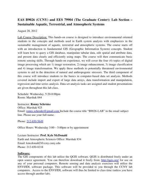
EAS B9026 (CCNY) and EES 79904 (The Graduate Center): Lab Section –Sustainable Aquatic, Terrestrial, and Atmospheric SystemsAugust 28, 2012Lab Course Description: This hands-on course is designed to introduce environmental orientedstudents to the concepts and methods used in Earth system analysis with emphasizes in thesustainable management of aquatic, terrestrial and atmospheric systems. The course starts offwith an introduction to fundamental GIS (Geographic Information System) concepts. Studentwill learn how to query a GIS database, manipulate tabular data, edit spatial and attribute data,and present data clearly and efficiently using maps. The course will then communicate basicremote sensing skills. Through hands-on experience, we will cover the four (4) topics of digitalimage processing which are 1) image restoration, 2) image enhancement, 3) image classificationand 4) image transformation. We apply these methods to potentially threatened environmentalsystems to aid in the detection of natural and anthropogenic stressors. The third component ofthis course will introduce students to the basics in computer-based data set analysis. Methodscovered include import and export of large data arrays, data transformation and manipulation,regression and time-series analysis. Data set analysis tasks are assigned and student presentationsare given throughout this lab class.Schedule: Wednesday, 5:20-8:00pmRoom: Marshak 044Instructor: <strong>Ronny</strong> SchröderOffice: Marshak 925Email: ronny.schroder@gmail.com Include the course title “B9026-LAB” in the email subjectline. Please use your full name.Phone: 212-650-5649Office Hours: Wednesday 3:00 – 5:00pm or by appointmentLecture Instructor: Prof. Kyle McDonaldEarth and Atmospheric Sciences Office: Marshak 834Email: kmcdonald2@ccny.cuny.eduPhone: 212-650-8218Software:The GIS components of this lab utilize the QGIS software. QGIS is distributed freely under anopen source agreement. You can therefore download it freely from: http://qgis.org/ for use onany of your personal computers. Remote sensing and data analysis exercises will utilize theENVI/IDL software package. This software will be provided to you through the CCNY labcomputers. Access to the ENVI/IDL software will thus be limited to class time (unless you haveaccess through another lab).
Data Sets:Some large data sets will be provided to you. Others are available on the web. You should utilizetime outside of class to download large datasets that you may be interested in. Do not count onlarge dataset downloading quickly and easily during lab time, as this may not always be reliable.Blackboard: All students are expected to use Blackboard. It is assumed that you will checkblackboard for all assignments and announcements. Blackboard includes a feature that sendsannouncements via email. I will communicate to you using these tools. If you do not check yourCCNY email regularly, please login to your CCNY account to forward your email to an accountthat you use. Blackboard may also be used to ask questions and provide feedback related tocarrying out the assignments. Be sure you have access to Blackboard!Course Requirements:Active participation; consistent and timely attendance.Timely completion of all required work. Late assignments will be reduced by one letter grade.Because of the participatory nature of the class, timely and consistent attendance is mandatory.You are allowed one absence or three late arrivals with no questions asked. Beyond that, wereserve the right to lower your semester grade, if appropriate.Etiquette:Silence cellular phones off during classPersonal laptops may be used for lab exercises.Please, no consumption of food during class.<strong>CUNY</strong> Policy on Academic Integrity:This will be posted on Blackboard.Be familiar with this!Lab Course Grading:1) Participation and Attendance- 10%2) Assignments 1-3, including presentations: 90%I. GIS-Analysis and Map Presentation due 9/25 (20%)II. RS-Analysis due 10/30 (30%)III. Multiple Data Set Analysis due 12/04 (40%)Note that due dates are on Tuesdays by 6:00pm!Assignments should be emailed to both instructors.
Note: Topic and assignment specifics are subject to modification during the semesterDate Topic Notes/Exercises08/29 Map Projections andCommon GIS Layers09/05 Tabular Data Import andGIS Queries09/12 Digitizing and Spatial DataExtractionRaster and vector data sets andtheir propertiesTabular data import and databasequeriesCommon GIS tasksAssignment I: GIS-Analysisand Map Presentation09/19 Map Elements andPresentation09/26 No Class - Yom KippurInstructions will be handed outGeneration of easily interpretedmaps, Assignment I: Questions10/03 Student Presentations Assignment I: Presentations (10minutes per student)10/10 No Class – Monday Schedule10/17 Remote Sensing Imageryand RestorationRemote sensing data sets,Radiometric and geometricrestoration techniques10/24 Image Enhancement Contrast Stretching, Compositesand Digital Filters10/31 Image Classification;Supervised and UnsupervisedClassificationAssignment II: RS-AnalysisInstructions will be given11/07 Image Transformation NDVI and Tasseled Cap,Assignment II: Questions11/14 Student Presentations Assignment II: Presentations (10minutes per student)11/21 No Class – ThanksgivingEve11/28 Introduction to ILD: DataImport and Export,Assignment III: Data setanalysisImport/Export of ASCII and Flat-Binary Files in IDLInstructions will be given12/05 Regression Analysis Explore correlations amongenvironmental variables,Causes or hints?Assignment III: Questions12/12 Final Student Presentation Assignment III: Presentations (10minutes per student)


