A New Tropospheric Propagation Delay Mapping Function for ...
A New Tropospheric Propagation Delay Mapping Function for ...
A New Tropospheric Propagation Delay Mapping Function for ...
- No tags were found...

You also want an ePaper? Increase the reach of your titles
YUMPU automatically turns print PDFs into web optimized ePapers that Google loves.
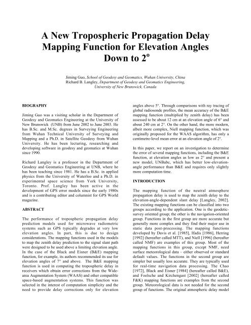
(a)(b)(c)
(d)(e)(f)Fig. 4. Mean biases of mapping functions (multiplied by vertical delay) at 10 radiosonde stations <strong>for</strong> elevation angles of (a)2°, (b) 4°, (c) 7°, (d) 10°, (e) 30°, and (f) 60°.
Fig. 5. Mean biases of mapping functions (multiplied by zenith delay) at 10 radiosonde sites during 1992.Fig. 6. r.m.s. errors of mapping functions (multiplied by zenith delay) at 10 radiosonde sites during 1992.From Figures 2 to 6, we draw the following conclusions:1) The rank by computing time is (fastest to slowest):B&E and F&K; Chao; UNBabc and UNBab; NMF. Theratios are approximately 1:1.5:3:13. Both UNBabc andUNBab take only about 3 times as long to compute values<strong>for</strong> both the hydrostatic and non-hydrostatic functions asthe B&E function and are more than four times faster thanNMF.2) The rank by accuracy (bias – smallest to largest) is:NMF; UNBabc; UNBab, F&K, B&E, and Chao (thedifferences among these four are small). In this lattergroup of four mapping functions, the individual functionsseem to have smallest biases at particular elevationangles: UNBab is best at 2-3°, B&E is good at 4°, whileF&K is the best above 6°.3) At very low elevation angles (2° and 3°), due to theneglect of ray bending and water vapor influence, theB&E and F&K functions have large biases. The curves ofChao, B&E, F&K diverge from those of NMF andUNBabc at the low elevation angles.4) The Niell mapping function is the best in accuracy, butit takes 13 times longer to compute than B&E.CONCLUSIONFrom its overall per<strong>for</strong>mance, we conclude that UNBabcis the best candidate <strong>for</strong> a GNSS receiver built-inmapping function. It takes much less time to computethan NMF does and has much better accuracy than B&E.The per<strong>for</strong>mance of UNBab (and Chao) shows that the 2-term continued fraction <strong>for</strong>m is not flexible enough <strong>for</strong> amapping function to cover the whole elevation anglerange down to 2°.
ACKNOWLEDGMENTSThe ray tracing software used in our work is a modifiedversion of the software developed by J.L. Davis, T.A.Herring, and A.E. Niell. The modifications wereper<strong>for</strong>med by J.P. Collins and V.B. Mendes. We also usedRAOBSCAN, a software module written by Collins. Wethank Niell, Mendes, and Collins <strong>for</strong> providing thesoftware and <strong>for</strong> their helpful advice. The support ofNavCanada and Chinese Scholarship Committee isgratefully acknowledged.REFERENCESBlack, H.D and A. Eisner (1984). “Correcting satelliteDoppler data <strong>for</strong> tropospheric effects”. Journal ofGeophysical Research, Vol. 89, No. D2, pp. 2616-2626.Chao, C.C. (1972). A Model <strong>for</strong> <strong>Tropospheric</strong> Calibrationfrom Daily Surface and Radiosonde BalloonMeasurement. Technical Memorandum 391-350, JetPropulsion Laboratory, Pasadena, CA.Collins, J.P. (1999). Assessment and Development of a<strong>Tropospheric</strong> <strong>Delay</strong> Model <strong>for</strong> Aircraft Users of theGlobal Positioning System. M.Sc.E. thesis, Departmentof Geodesy and Geomatics Engineering TechnicalReport No. 203, University of <strong>New</strong> Brunswick,Fredericton, N.B., Canada, 174 pp.Davis, J.L., T.A. Herring, I.I. Shapiro, A.E.E. Rogers, andG. Elgered (1985). “Geodesy by radio interferometry:Effects of atmospheric modeling errors on estimates ofbaseline length”. Radio Science, Vol. 20, pp. 1593-1607.Fleming, E.L., S. Chandra, M.R. Schoeberl and J.J.Barnet (1988). Monthly Mean Global Climatology ofTemperature, Wind, Geopotential Height and Pressure<strong>for</strong> 0-120km. NASA TM-100697, Goddard Space FlightCentre, Greenbelt, MD.Foelsche, U. and G. Kirchengast (2002). “A simple‘geometric’ mapping function <strong>for</strong> the hydrostatic delayat radio frequencies and assessment of itsper<strong>for</strong>mance”. Geophysical Research Letters, Vol.29,No.10, pp. 1111-1114.Herring, T.A. (1992). “Modeling atmospheric delays inthe analysis of space geodetic data”. Proceedings of theSymposium on Refraction of Transatmospheric Signalsin Geodesy, Eds. J.C. De Munck and T.A.Th. Spoelstra,Netherlands Geodetic Commission, Publications onGeodesy, No. 36, pp.157-164.Ifadis, I.M. (1986). The Atmospheric <strong>Delay</strong> of RadioWaves: Modeling the Elevation Dependence on aGlobal Scale. Technical Report 38L, ChalmersUniversity of Technology, Gothenborg, Sweden.Langley, R.B. (2002). Monitoring the Ionosphere andNeutral Atmosphere with GPS. Viewgraphs of invitedpresentation to the Canadian Association of PhysicistsDivision of Atmospheric and Space Physics Workshop,Fredericton, N.B., 21-23 February 2002.Marini, J.W. (1972). “Correction of satellite tracking data<strong>for</strong> an arbitrary tropospheric profile”. Radio Science,Vol. 7, No. 2, pp. 223-231.Mendes, V.B. (1999). Modeling the Neutral-atmosphere<strong>Propagation</strong> <strong>Delay</strong> in Radiometric Space Techniques.Ph.D. dissertation, Department of Geodesy andGeomatics Engineering Technical Report No. 199,University of <strong>New</strong> Brunswick, Fredericton, N.B.,Canada.Niell, A.E. (1996). “Global mapping functions <strong>for</strong> theatmosphere delay at radio wavelengths”. Journal ofGeophysical Research, Vol. 101, No. B2, pp. 3227-3246.RTCA SC-159, (1999). Minimum OperationalPer<strong>for</strong>mance Standards <strong>for</strong> Global PositioningSystem/Wide Area Augmentation System AirborneEquipment, RTCA/DO-229B, RTCA Inc., Washington,D.C.