Effectiveness of horizontal drains in improving slope stability: a case ...
Effectiveness of horizontal drains in improving slope stability: a case ...
Effectiveness of horizontal drains in improving slope stability: a case ...

Create successful ePaper yourself
Turn your PDF publications into a flip-book with our unique Google optimized e-Paper software.
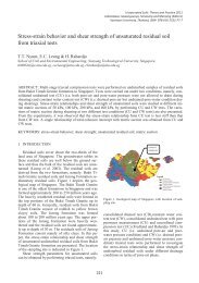
2 FIELD STUDY2.1 Background <strong>of</strong> PutrajayaPutrajaya is a planned city, located 25 km south <strong>of</strong>Kuala Lumpur and 20 km north <strong>of</strong> the KualaLumpur International Airport (KLIA) that serves asthe federal adm<strong>in</strong>istrative centre <strong>of</strong> Malaysia. Thecity sits on 4,931 hectares <strong>of</strong> land with<strong>in</strong> theMultimedia Super Corridor. Its development started<strong>in</strong> 1995 and is targeted to complete by 2015. Oncefully developed, it is estimated to have a population<strong>of</strong> around 320,000 with 64,000 hous<strong>in</strong>g units.2.2 The Putrajaya landslideA landslide occurred at a <strong>slope</strong> adjacent to 3 blocksconta<strong>in</strong><strong>in</strong>g 334 government quarters at Prec<strong>in</strong>ct 9,Putrajaya, at around 4:30am on the 22 nd March2007. The panaromic view <strong>of</strong> the landslide <strong>in</strong> Figure1, reproduced from the report that appeared <strong>in</strong>the New Straits Times on 23 rd March 2001, providesgraphic illustration <strong>of</strong> the landslide, the location <strong>of</strong>the site and an <strong>in</strong>dication <strong>of</strong> the distance from the<strong>slope</strong> to the adjacent apartment build<strong>in</strong>gs.Figure 1. Panaromic view <strong>of</strong> the <strong>slope</strong> failure, (New StraitsTimes, 23 rd March 2007).There was no <strong>in</strong>jury or fatality, but 27 cars were totallyor partially buried by the debris material. Allresidents <strong>of</strong> the 3 blocks, i.e. about 1,200 people,were immediately evacuated. It was therefore crucialto stabilize the affected <strong>slope</strong> prior to allow<strong>in</strong>gthe residents to reoccupy the build<strong>in</strong>gFigure 2. Digital Terra<strong>in</strong> Model (DTM) <strong>of</strong> the landslide area.2.4 Geology <strong>of</strong> the siteFrom the field surface mapp<strong>in</strong>g, the study area isunderla<strong>in</strong> by graphitic quartz mica schist from KajangFormation (see Figure 3). The outcrops whichcould be noted along the cut <strong>slope</strong>s <strong>in</strong> the study areahave experienced <strong>in</strong>tense weather<strong>in</strong>g processes withweather<strong>in</strong>g grade range from Grade III to VI. HoweverGrade II material could still be noted at certa<strong>in</strong>areas. Foliation planes were clearly formed andcould be seen on the cut <strong>slope</strong>s. The orientation isquite consistent, i.e. strik<strong>in</strong>g approximately N-S anddipp<strong>in</strong>g towards W-EW with average dips <strong>of</strong> 35 o to40 o .Study Area2.3 Site description <strong>of</strong> landslide areaThe site is best described by the Digital Terra<strong>in</strong>Model <strong>in</strong> Figure 2. The landslide is located on thewestern face <strong>of</strong> a ridge that has its crest close to theupper edge <strong>of</strong> the slide scarp. A road lead<strong>in</strong>g to a 36million litre water tank lies on this crest. The watertank is partially buried on a part <strong>of</strong> the hill that hasbeen cut to prepare a flat site for it. The distance <strong>of</strong>the tank to the edge <strong>of</strong> the ridge where the slide occurredis about 25m.Kenny HillFormationKajangFormationFigure 3. Geology map <strong>of</strong> study area754