KPB Surveyor - Kenai Peninsula Borough
KPB Surveyor - Kenai Peninsula Borough
KPB Surveyor - Kenai Peninsula Borough
- No tags were found...

You also want an ePaper? Increase the reach of your titles
YUMPU automatically turns print PDFs into web optimized ePapers that Google loves.
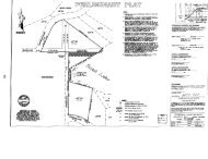
35186 Spur Hwy Soldotna, AK 99669 (907)26':" 06/14/02 Rainwater Ranch 2<strong>KPB</strong> 2002-112MEMORANDUMSoil Report original for Max Best14 June 2002 00090To:Max Best<strong>KPB</strong> <strong>Surveyor</strong>Ken HuntEd MauriceAbility SurveysMike TauriainenSubject:Voznesenka Village Community Water SystemRainwater Ranch, Lot 1 Subdivision, Soils Investigation1 page + AttachmentsThis report is being submitted for the subdivision of Lot 1, Rainwater Ranch, containing 131.914acres into Rainwater Ranch 2, containing two lots. Lot 1-8 is a 4.0 acre lot to accommodate awater storage tank, a water treatment building, wells and related improvements; Lot 1-Acontains 127.9 acres and includes a residence and related improvements.We performed a foundation soils investigation on 27 March 02 for the proposed water storagetank site for the Village of Voznesenka (report attached). The treatment building will include atoilet and lav discharging less than 50 gpd to an onsite septic system. Soils in the probablestrata for on-site wastewater systems are considered suitable.The subdivision is bounded by unsubdivided property and by East End Road to the south andRainwater Lane to the east. Lot 1-B is within the NEY4 NEY4 S27, T4S, R11W, S.M, in the<strong>Kenai</strong> <strong>Peninsula</strong> <strong>Borough</strong> near Voznesenka, Alaska. The lot is undeveloped except for twoClass A wells; Well 6A is within 30' of Well 6B; the other improvements shown on the site areproposed. No other development is within 200' of the site. See attached Working Map.Based on our site investigation, the lot has more than 20,000 sf suitable for on-site wastewatersystems and other development. We recommend a shallow trench or bed soil absorptionsystem placed in the sandy soils below about nine feet. Wastewater treatment and disposalsystems must be located at least 200' from the Class A wells. The water supply andwastewater treatment and disposal system are being designed and will be reviewed by ADEC.Please call if you have any questions.END OF MEMO TEXTF :\W'IPROJ ECT S\ VOZN ESN K\ VOZ2BWOZ 4 7 KP Bsoils wpd
DATE:IIvI/APPROX TEXT HOLE LOCATIONAPPROX 4.0ACRES~ D !k
VOZNESENKA,ALASKACOMMUNITY WATER SYSTEMWATER STORAGE TANK SITEGEOTECHNICAL INVESTIGATIONPrepared for:Voznesenka Community CouncilandVillage Safe WaterPrepared byMike Tauriainen, P.E.Consulting Engineers, Inc.35186 Spur HighwaySoldotna, AK 99669May, 20022000090
Mike I aurlalnen, JJ.E., Consulting Engineers, Inc.35186 Spur Hwy Soldotna, AK 99669 (907)262-4624 FAX 262-5777(MEMORANDUMDate: 30 May 02To:Ken Hunt, VSWNazary Basargin, VCC00090Subject:Ed MauriceMike TauriainenVoznesenka Water SystemStorage Tank Site Geotechnical1 page + AttachmentsReportEnclosed is the geotechnical report for the Voznesenka Water System tank site and relatedfacilities. The work was performed in general accordance with our standard geotechnicalinvestigation procedures. Soils encountered were generally stiff to hard silts, reasonably wellsuited for use as foundation subgrade.The recommendations contained herein reflect our understanding of the project and ourinterpretation of available data. We recommend that a qualified geotechnical engineer beretained during construction to observe excavation, backfill and compaction operations and totest, as necessary, the backfill prior to placement of reinforcing steel in footings, and allexcavation and fill below the storage tank.Please call if you have any questions or require additional information.END OF MEMO TEXTF :\v..?\PROJECT S\ VaIN ESN K\ VOZ2BW oz SoilR pt wpd
VOZNESENKA WATER SYSTEMWA TER STORAGE TANKGEOTECHNICAL INVESTIGATIONTABLE OF CONTENTS1 INTRODUCTION.1.1 Background1.2 Scope. ...1112 SITE TOPOGRAPHIC, GEOMORPHIC AND GEOLOGIC CONDITIONS 13 FIELD INVESTIGATION AND FIELD AND LABORATORY TESTING.. l.24 SUBSURFACE SOil, SURFACE- AND GROUND-WATER CONDITIONS. ...~ 35SITE IMPROVEMENT RECOMMENDATIONS AND CONCLUSIONS. , 35.1 Site Improvements , 35.2 Bearing Capacity ~ 35.3 Settlement 45.4 Fill & Backfill 45.5 Footings & Slabs. 55.5.1 ShallowFootingAltemate 55.5.2 Isolated Footings. 55. 6 Drainage and Embankments. t 55. 7 FrostAction ; 65. 8 Construction 66 CLOSURE7APPENDICES:Appendix A: Test Hole Location MapAppendix B: Test Hole LogsAppendix C: Lab Results
excavation to competent soils will be necessary followed with suitable compacted backfill. Werecommend that a qualified geotechnical engineer be retained to observe the excavation,backfill and compaction operation and to observe and test, as necessary, the backfill prior toplacement of reinforcing steel in footings, and all excavation and fill below the storage tank.Footings& SlabsPerimeter footings should be placed at least 42" below the finish grade. All footings should beplaced on sandy gravel backfill compacted to 95% relative compaction as specified in ASTM 0-15570 with a rock correction factor according to Alaska Test Method T -11 if appropriate.Siabs-on-grade95% relative compaction.can be supported on a minimum of 12'1 of NFS backfill compacted to at leastAll structural fill should be placed over a geotextile fabric to separate it from the underlying silts5.5.1 Shallow Footing AlternateAn alternate shallow, insulated, footing system may be considered for heated buildingsconsisting of a footing monolithic with the floor slab, or a short stem wall. This footing shouldbe set to a minimum depth of 18 inches below finish grade in accordance with 5.5 above. Twoinches of extruded polystyrene insulation should be placed vertically against the outside of thefoundation, then extended outward a sufficient distance (approximately three feet in the Homerarea) to avoid frost penetration beneath the footing.Isolated FootingsIsolated, unheated footings should be placed a minimum of five feet below finish grade andinsulated with rigid insulation placed at least two feet below finish grade and extending at leastthree feet beyond the outside edges of the footing. Interior column footings should be placed atleast two feet below finish floor elevation.5.6 Drainage and EmbankmentsThe site is gently sloping and final site grading should provide for positive drainage away fromstructures and parking areas. Site development may require special consideration to handle upslope drainage to prevent future drainage problems, particularly with regard to the tankfoundation soils. Concentrated roof drainage should be directed away from structures asshould drainage from parking areas. A finish floor elevation at least twelve inches abovesurrounding grade is desirable. Minimum slopes of 5% should be provided to 10 feet away
from structures to promote drainage in unsurfaced areas.Unpaved drives and parking areas should have minimum slopes of 2% to promote drainage.The subbase should consist of at least 18" of classified gravel meeting the gradationrecommended under Fill & Backfil~ placed over a geotextile separation fabric.5.7 Frost ActionThe depth of frost penetration on site depends on several factors, the most important being soilconditions, exposure, and weather. For the silty soils encountered, with a surface kept clear ofsnow, normal depths of freeze can be expected to approach six feet. The frost will penetratedeeper where silts have been replaced with granular soils. The actual frost penetrationadjacent to properly designed footings of heated buildings will be much less.We recommend use of water-resistant, rigid polystyrene insulation placed against the outside ofexterior foundation walls and extending approximately 3% feet below grade (18" with shallowfooting alternate) to provide a thermal barrier and bond break against frost action. Theinsulation should be protected against mechanical and UV damage where it extends abovegrade. Precautions should be taken to prevent heaving of footings, slabs, and relatedconstruction, particularly at entries. We recommend that all surface silty soils be removed andreplaced with NFS backfill beneath exterior slabs, entries, or stairs and that positive drainageaway from these areas be provided. Rigid polystyrene insulation may be utilized in lieu of, or inaddition to NFS material.Exterior concrete slabs should not be connected to footings to reduce effects of differentialmovement due to frost action. Adequate control joints should be placed to control cracking. Allexterior slabs and pavements may be separated from the building structure by weather-sealedjoints to control stress concentration and crack development. Exterior slab grades should beheld at least 3/4 inch below finished floor grade at all entrances to the building to allow for slightdifferential movement unless required otherwise for handicapped access.5.8 ConstructionSome of the softer site soils may be unstable and trench walls may slough without warning.Special attention should be given to maintaining the existing soils in a relatively unsaturatedstate due to significant workability problems and loss of bearing capacity when wet.Construction activities may render the soils temporarily unworkable, even at normal moisturelevels. Surface runoff could impact the site and some dewatering of excavations or diversion ofup slope runoff may be necessary.
Compaction of backfill and frost susceptibility of soils should be carefully monitored duringconstruction. The existing soils at the bottom of any excavation should be maintained in theirnatural conditions, or compacted if necessary.All subgrades supporting slabs or structures should be proof rolled with a loaded dump truckprior to placement of fabric. Any soft areas should be excavated and backfilled as described in5.4 Fill and Backfill.6 CLOSUREThis investigation was conducted according to MTPE procedures to evaluate site geote(:hnicalconditions. This report was prepared solely for Voznesenka Village Council and Village SafeWater to present the findings of our investigation regarding suitability for site development andbuilding construction for the proposed four-acre tract near Voznesenka, Alaska. Informationsupplied by others, and used in this report, are from sources believed to be reliable, but noresponsibility is assumed for accuracy.This report is based on information collected during our investigation, our understanding of theproposed structure and performance criteria, and upon the application of scientific principlesand professional judgement to certain facts with resultant subjective interpretations. Due to thevariable nature of site soils and geology, and the limited investigation, subsurface conditionsmay vary from the information in this report. Professional judgements expressed herein arebased on facts currently available within the limits of existing data, scope of work, budget andschedule.Our conclusions and recommendations are intended as guidance and not necessarily a firmcourse of action, unless explicitly stated; other techniques and options may also be desirable.more definitive conclusions are desired than are warranted by currently available facts,additional investigation is recommended. Deviations from the information provided could alterour recommendations. We would appreciate the opportunity to review and evaluate anysignificant foundation-related changes. We recommend the site grading and foundationpreparation work be inspected by a qualified engineer during construction to verify thatconditions are as anticipated in the design. If conditions are found to differ significantly fromthose described in this report, please contact us immediately.IfWe are available to discuss this report to examine options and respond to designer's questionsas they arise. MTPE makes no warranties as to merchantability or fitness for a particularpurpose. Any use of this report, or conclusions drawn, by third parties is at their own risk.
APPENDIXATEST HOLE LOCATION MAP
~ n Ik @F~'a1~1ru~ ~ 0 I:§ 0CONSULTING ENGINEERS. INC.35186 SPUR HWY.SOLDOTNA, ALASKA 99669(907) 262-4624FAX 262-5777DATE:JUNE 2002DRAWN:CHECKED: R SYKESSCALE:PROJECT NOM TAURIAINEN1~ = 80'2000-090VOZNESENKA TANK SITE WATER!YSTEMPLANTEST HOLE LOCATIO SSHEETOF1
APPENDIX BTEST HOLE LOGS
,3.5'TEST HOLE LOGSTH 1 27 Mar 020 -1.7'1.7 -3.3'3.3 -5.0'5.0 -9.5'9.5 -12.0'Organics and SILT, brown, moist (ML)Frozen, 0 -12"SILT wI tr Sand & stones, red brown to olive, moist, soft-firm (ML)Pocket Penetrometer readings: 0.5 -1.0 tsfSILT wI tr Sand & sm stones, olive, mottled, moist, hard (ML)Pocket Penetrometer readings: 4.5 tsfSILT wI occ Cobbles, tan-gray, moist, stiff (ML)Soil smears; Pocket Penetrometer readings: 3.5 -4.5 tsfSandy SILT fine, tan, grading to Silty SAND fine, gray, moist, mod dense(ML. 8M)Occasional boulders below 3'TO 12.0', No ground water table encounteredTH 2 27 Mar 020 -1.3'1.3 -3.5 - 5.5'5.5 - 7.0'7.0 - 8.0'8.0 -8.5'Organics and SILT, brown, moist (ML)Frozen, 0 -12"SILT wI tr Sand & stones, red brown to olive, moist, 50ft-firmSILT wI tr Sand & sm stones, tan, moist, hard (ML)SILT wI tr Sand & sm stones, gray, moist, hard (ML)SILT wI occ Cobbles, tan-gray, moist, hard (ML)SILT wI occ Cobbles, tan, moist, hard (ML)(ML)Occasional boulders below 3'TO 8.5', No ground water table encounteredNotes:Approximately 4' snow cover entire areaHoles dug with Case 880C backhoeApproximate site elevation: 1340' MSL
APPENDIXCLAB RESULTS
--Name: Mike Tauriainen, P.E., Consulting Engineers, Inc.Address: 35186 <strong>Kenai</strong> Spur HwyCity: Soldotna, AK 99669Attention:Date:Project:Project No.:Fax To:April 2, 2002Voznesenka Tank Site20000908
1 INTRODUCTION1.1 BackgroundThe Village of Voznesenka proposes to build a water storage tank and water treatment buildingto serve the Voznesenka Water System. The site is part of a 132-acre tract owned by Chrisand Mike Rainwater in Sections 26 and 27, Town 4 South, Range 11 West, Seward Meridiannorth of Voznesenka and east of Homer, Alaska, near the intersection of East End Road andRainwater Lane. The site of interest consists of approximately 4 acres and has noimprovements. The site has been previously logged and is shown on the test hole location map(Appendix A).Snow, wind, and seismic loads for the proposed terminal are considered typical of the Homerbench/Caribou Hills area. Recommended design snow and wind loads are 80 psf and 130 mph(3 second gust) Exposure C, respectively. Voznesenka is in UBC Seismic Zone 4.Mike Tauriainen, P.E. Consulting Engineers, Inc. (MTPE) performed a foundation soils;investigation on 27 March 02 for the proposed water storage tank site. A partial topographicsurvey of the site with two-foot contour intervals was performed by Ability Surveys. Additionaltopo information will be collected by Ability.1.2 ScopeWe have conducted a subsurface soils investigation, laboratory testing and analysis of the datasufficient to prepare this report of soil and groundwater conditions encountered, foundation soilcharacteristics, static bearing, static settlement and general site preparation and foundationrecommendations for the proposed improvements.The proposed improvements include a 320,OOO-gallon water storage tank, a single-story watertreatment building with spread footings and a slab-on-grade floor, access drive andunderground water main. Foundation and floor loads are expected to be relatively light tomoderate. Normal traffic loads are expected to be autos and light trucks.2 SITE TOPOGRAPHIC, GEOMORPHIC AND GEOLOGIC CONDITIONSThe site is gently to moderately sloping to the south and east. Total site relief is about twentyfivefeet. Site elevation is approximately 1330 -1350 feet above mean sea level. The site hasbeen previously logged and is vegetated with a few small trees and native grasses.
The site is bordered to the south by the East End Road, and to the east by the Rainwater Laneright-ot-way.Voznesenka is located on the Southern <strong>Kenai</strong> Lowland and according to the USGS IProfessional Paper 443, Quaternary Geoloav of the <strong>Kenai</strong> lowland and Glacial History of theCook Inlet Reaion. Alaska, the soils in the area are part of the Caribou Hills Upland and relatedto "moraines of Naptowne glaciation, prominent and little modified. ..limit of Skilak advance. ..mantled by loess, generally 2-6 ft thick"The USDA Soil Survey of Homer-Ninilchik Alaska indicates that the soils are Kachemak siltloam, gently sloping.. These are "well-drained, shallow to moderately deep soils that occur onuplands and are nearly level to steep. These soils formed in volcanic ash mixed with silt blownfrom ~cently exposed glacial drift. Below the volcanic ash are layers of moderatelyconsolidated shale and sandstone. III..cThe soil strata encountered in the test holes are similar and tend to support these generalizedinterpretations of the soils and geology; however, little evidence of volcanic ash was noted.Available geological mapping of the area is at a small scale and matching map geological andsoils boundaries with actual field locations is difficult.3 FIELD INVESTIGATION AND FIELD AND LABORATORY TESTINGA field investigation was performed 27 Mar 2002 utilizing a Case 880C track-mounted backhoeTwo test pits (TH 1 and 2) were dug to depths of 12.0 and 8.5 feet. Test pits were field loggedby Mike Tauriainen. Approximate test hole locations are shown on the test hole location map.Test hole logs are presented in Appendix B.IPenetrometer tests were performed (using SoilTest Pocket Penetrometer CL-700) in selectedsidewall locations in TH 1 to provide an indication of unconfined compressive strength.Readings of about 0.5 -1.0 tsf at a depth of 2 -3' indicate soft to firm soils; readings of 3.5 tomore than 4.5 tsf at a depth of 3.5 -8' indicate stiff to hard soils. The soils in TH 2 were similar.Representative grab samples were obtained from undisturbed material in selected sidewalllocations. Each sample was visually characterized in the field. Laboratory gradations wereperformed to verify soil classifications and are presented in Appendix C.Mike Taunalnen, PE,Vaznesenka Water SystemConsulting Engineers, Inc 2 Tank Site Geotechnical ReportSoldotna Alaska May 2002
4SUBSURFACE SOIL, SURFACE- AND GROUND-WATER CONDITIONSSoils consisted predominantly of stiff to hard silts below about 3.5'. Sandy silt grading to siltysand was encounteredbelow about 9' in TH 1. Soils in both test pits were relatively uniform.Snow cover at the time of investigation was about four feet. Frost was encountered in both testpits from the surface to one foot. No surface water was observed on site at the time of theinvestigation, however, during a later visit (May 2) a small drainage and culvert under East EndRoad were noted. No ground water was encountered to the depths of exploration. I.J5SITE IMPROVEMENT RECOMMENDATIONS AND CONCLUSIONSA soil-supported tank with ring wall foundation, and a single-story building with conventionalslab on grade and spread footings are proposed for this facility. Site soil conditions are suitablefor this type of construction. All surface soils containing organic material, organic silt, frozensoil, or trash should be removed from areas to receive structural improvements such asfootings, slabs, pavements, or structural fill.The opinions and recommendations expressed with respect to bearing characteristics in~ludequalitative considerations of probable dynamic bearing characteristics of the foundation soils. Itis our opinion based on this data that ground response will be that associated with moderatelydense glacial deposits resulting in strong ground motion. A seismic evaluation is not within thescope of this investigation. .ISite ImprovementsOur recommendationsare based on the following proposed site improvements and our currentunderstanding of the project.1. Construction of a 24'-high water storage tank. j'f2. Construction of a one-story, wood-frame building with continuous footing~.3. Construction of gravel parking and driveway access.4. Installation of buried utilities: water, sewer. electric, and telephone service.Bearing CapacityA maximum allowable bearing capacity of 2500 psf is recommended for the stiff to hard siltsbelow three feet provided any loose soils are adequately compacted or removed. Any soilsthat do not respond to compactive efforts should be replaced. The allowable bearing capacityshould be proportionately reduced for footings less than 18" wide, to 2000 psf for 12" widefootings.
Long-term loads such as the water storage tank should be reduced to 2000 pst.Continuous strip footings used to support exterior and interior bearing walls should be at least18 inches wide. Other footings should be a minimum of one foot wide. Isolated footings shouldbe a minimum of two feet wide. Allowable bearing capacity may be increased 33% for wind andseismic loads.5.3 SettlementSome minor uniform and differential settlement can be expected. The expected magnittJde oftotal settlement is estimated to be between 0.5 and 1.0 inches. Differential settlement could beup to 3/4 of the total under design loading conditions, provided the recommendations of thisreport are followed. In order to minimize the effects of settlement, foundation elements shouldbe continuous where possible and slabs should be isolated from column footings.5.4 Fill & BackfillImported fill/backfill under footings, slabs and tanks should be reasonably-well-graded, nonfrost-susceptible(NFS) soils able to be compacted to a firm, unyielding surface, placed inmaximum loose lifts of 9 -12 inches. For local material meeting the following gradation andcompacted to at least 95% of the maximum density, an allowable bearing capacity of up to3000 psf may be used at the upper surface of the backfill provided the loading of the in-situsoils does not exceed the allowable noted under Bearing Capacity. Soils not meeting thisgradation should be evaluated on an individual basis. I 1SIEVEPERCENT PASSING4" 1001" 70-100#4 35-75#200 2-10Backfill should extend from the bottom edge of footings to undisturbed soil at a maximum of1 :2. horizontal to vertical. The upper six inches of backfill below footings or slabs should have amaximum size limit of two inches.The on site silts are probably marginal for backfill material when disturbed and should not beused as structural backfill. r 1Should unsuitable subgrade soils be encountered or identified during excavation, additionalMike Taunalnen, PE. Vazne~nka Water SystemConsulting Engineers, Inc. 4 Tank Site Geotechnical ReportSoldatna, Alaska May 2002